A brief reprieve from the intense cold in southern Alberta heading into 2022
UPDATE: I have precious little to add for updates. The link to the Weather Summaries page has fallen off, now. Check this link here, or see below for the December 27 new low temperature records.
All I've really had to do is tighten in the forecast - a single degree up or down, in most cases.
The Environment Canada forecast out to Saturday shows a little more optimistically than I do at this time - we're all blameless, though calling me out as a pessimist is fair! We'll wait to see what happens when it gets closer.
With our temperatures improving, somewhat (I use the word "improving" loosely), we can expect to see some of these Extreme Cold Warnings fall away by tomorrow. It'll still be unpleasant, but not "large-scale frostbite risk" unpleasant.
We’ve been calling it ripe in our household. Would love to hear your preferred term for it on Twitter, just to mix the language up a bit.
Regardless, after record-breaking cold temperatures pressed into the province over the weekend (and I mean it – here’s the Weather Summaries page, copied as plain text at the bottom, in case this disappears to roll into the next wave.
Today, we take a minor reprieve (?) from the cold stuff, if briefly; westerly wind above us will be responsible for that, but breaking through the layer of downright frigid temperatures will take a whole lot more than one short-wave. Periods of snow should be expected today – the kind requiring a snow-brush, and perhaps not the shovel.
Once that heads on, we’re back to northerly wind. If there’s reprieve from the extreme cold warnings that, as 7 a.m. Tuesday, continue blanketing much of the province, we’ll just go on ahead and hop back into those by this evening.
Because wind chill values will likely creep back toward -40 overnight, Calgary may remain under the warning for a while longer.
How much longer?
I’ve peeked out to the middle of next week at our upper air pattern. Model confidence is pretty darned high that the jet stream will remain through or near the central U.S. for that time.
A brief respite will arrive this weekend, through New Year’s Day; it’s a product of a Pacific low opening us to potential chinook conditions.
Again to model confidence, this is a middling approach; that is to say, there’s a shot at seeing temps near-seasonal for a day or two just beyond our five-day forecast — but since it’s beyond our five-day forecast, I’m not shoving my chips in on that just yet.
Thanks as always to the great and powerful Rolf for compiling this sort of data.
Your five-day forecast:
Tonight
Flurries, low -30 C
Wednesday
Sunny
Daytime high: -20 C
Evening: some cloud, low -24 C
Thursday
Partly cloudy
Daytime high: -17 C
Evening: clear, low -27 C
Friday
New Year's Eve - Mainly sunny
Daytime high: -18 C
Evening: mainly clear, low -20 C
Saturday
New Year's Day - Partly cloudy
Daytime high: -7 C
Evening: some cloud, flurries, low -8 C
Sunday
Mainly sunny
Daytime high: -3 C
Evening: some cloud, low -11 C
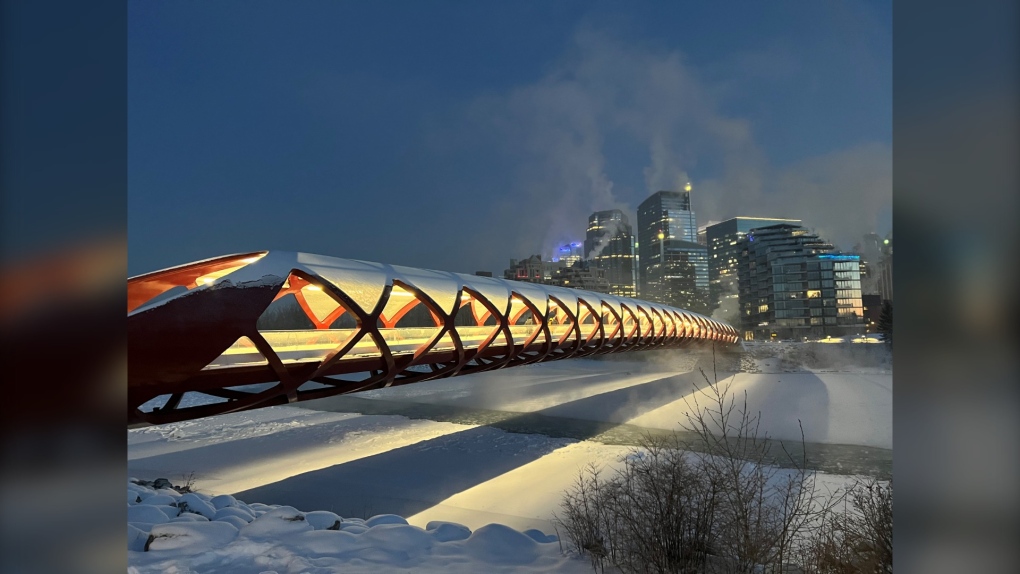
In weather pics today, thanks to Matthew for braving a chilly evening – great shot!
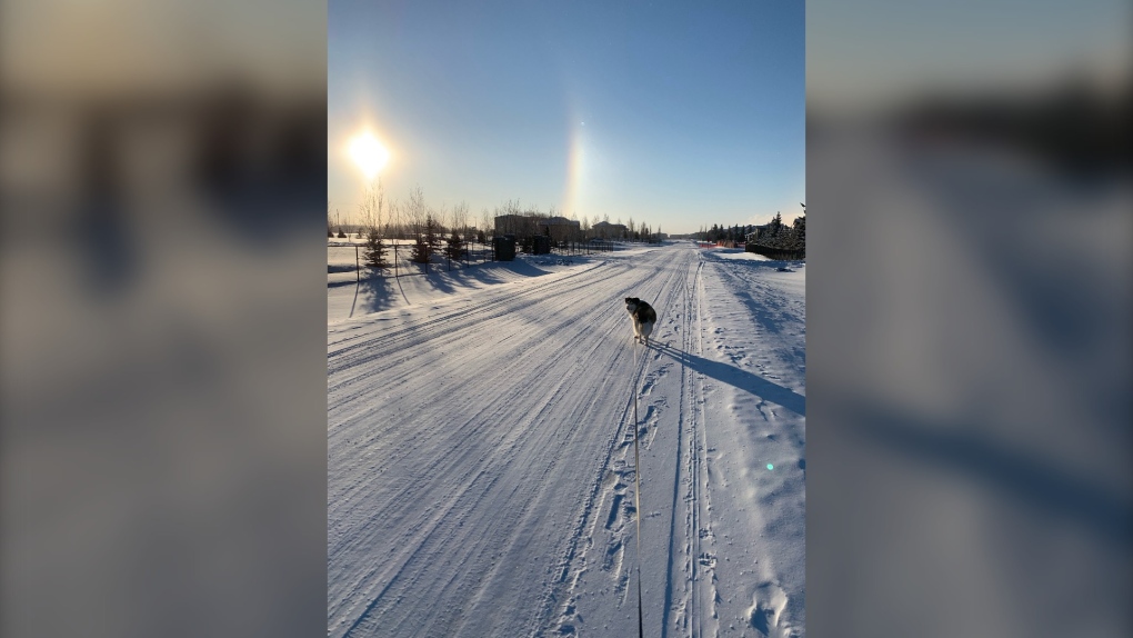
And a couple of sun dogs here from Paul in Conrich:
You can submit your photos here, email me here, or tweet them over!
And as promised, the records info:
Weather summary
for Alberta
issued by Environment Canada
at 11:38 a.m. MST Monday 27 December 2021.
Discussion.
A cold, arctic airmass has settled into the province setting several
temperature records on Boxing day and December 27. Temperatures will
remain below normal through the week.
The following areas set a daily minimum temperature record on
December 27, 2021.
Airdrie Area
New record of -40.6
Old record of -36.1 set in 1968
Records in this area have been kept since 1881
Banff Area
New record of -37.2
Old record of -34.4 set in 1934
Records in this area have been kept since 1881
Bow Valley (Provincial Park) Area
New record of -40.4
Old record of -35.6 set in 1968
Records in this area have been kept since 1928
Cardston Area
New record of -36.4
Old record of -31.1 set in 1934
Records in this area have been kept since 1918
Claresholm Area
New record of -36.8
Old record of -31.1 set in 1968
Records in this area have been kept since 1951
Coronation Area
New record of -36.4
Old record of -36.1 set in 1968
Records in this area have been kept since 1912
Drumheller Area
New record of -37.8
Old record of -35.0 set in 1996
Records in this area have been kept since 1923
Edmonton International Airport
New record of -41.6
Old record of -38.0 set in 1992
Records in this area have been kept since 1959
Elk Island (National Park) Area
New record of -40.0
Old record of -35.5 set in 1996
Records in this area have been kept since 1966
Grande Prairie Area
New record of -44.4
Old record of -43.1 set in 1984
Records in this area have been kept since 1922
Jasper Area
New record of -39.5
Old record of -36.7 set in 1996
Records in this area have been kept since 1916
Nordegg Area
New record of -40.7
Old record of -39.4 set in 1968
Records in this area have been kept since 1915
Pincher Creek Area
New record of -35.9
Old record of -33.9 set in 1968
Records in this area have been kept since 1893
Sundre Area
New record of 40.9
Old record of -36.2 set in 1996
Records in this area have been kept since 1993
Waterton Park Area
New record of -37.2
Old record of -27.1 set in 1996
Records in this area have been kept since 1976
Note: The day has not ended and some values could still be exceeded
before the end of the day.
The following areas set a daily minimum temperature record on
December 26, 2021
Bow Valley (Provincial Park) Area
New record of -38.5
Record of -33.7 set in 2017
Records in this area have been kept since 1928
Hendrickson Creek Area
New record of -42.5
Old record of -35.8 set in 2017
Records in this area have been kept since 1995
High River Area
New record of -33.7
Old record of -33.4 set in 2017
Records in this area have been kept since 1913
Highvale Area
New record of -32.6
Old record of -31.2 set in 2017
Records in this area have been kept since 1977
Red Earth Creek Area
New record of -37.5
Old record of -36.9 set in 2017
Records in this area have been kept since 1994
Waterton Park Area
New record of -34.2
Old record of -33.2 set in 2017
Records in this area have been kept since 1976
Note: the temperature records reported here have been derived from a
selection of historical stations in each geographic area that were
active during the period of record.
Please note that this summary may contain preliminary or unofficial
information and does not constitute a complete or final report.
End/PASPC


CTVNews.ca Top Stories

Quebec nurse had to clean up after husband's death in Montreal hospital
On a night she should have been mourning, a nurse from Quebec's Laurentians region says she was forced to clean up her husband after he died at a hospital in Montreal.
Cuban government apologizes to Montreal-area family after delivering wrong body
Cuba's foreign affairs minister has apologized to a Montreal-area family after they were sent the wrong body following the death of a loved one.
What is changing about Canada's capital gains tax and how does it impact me?
The federal government's proposed change to capital gains taxation is expected to increase taxes on investments and mainly affect wealthy Canadians and businesses. Here's what you need to know about the move.
'Anything to win': Trudeau says as Poilievre defends meeting protesters
Prime Minister Justin Trudeau is accusing Conservative Leader Pierre Poilievre of welcoming 'the support of conspiracy theorists and extremists,' after the Conservative leader was photographed meeting with protesters, which his office has defended.
Northern Ont. lawyer who abandoned clients in child protection cases disbarred
A North Bay, Ont., lawyer who abandoned 15 clients – many of them child protection cases – has lost his licence to practise law.
'One of the single most terrifying things ever': Ontario couple among passengers on sinking tour boat in Dominican Republic
A Toronto couple are speaking out about their 'extremely dangerous' experience on board a sinking tour boat in the Dominican Republic last week.
Boeing's financial woes continue, while families of crash victims urge U.S. to prosecute the company
Boeing said Wednesday that it lost US$355 million on falling revenue in the first quarter, another sign of the crisis gripping the aircraft manufacturer as it faces increasing scrutiny over the safety of its planes and accusations of shoddy work from a growing number of whistleblowers.
Bank of Canada officials split on when to start cutting interest rates
Members of the Bank of Canada's governing council were split on how long the central bank should wait before it starts cutting interest rates when they met earlier this month.
Fair in Ontario, flurries in Labrador: Weather systems make for an erratic spring
It's no secret that spring can be a tumultuous time for Canadian weather, and as an unseasonably mild El Nino winter gives way to summer, there's bound to be a few swings in temperature that seem out of the ordinary. From Ontario to the Atlantic, though, this week is about to feel a little erratic.
Shopping Trends
The Shopping Trends team is independent of the journalists at CTV News. We may earn a commission when you use our links to shop. Read about us.


Edmonton
-

Nurse practitioners to make 80% as much as family doctors for publicly-funded primary care
The Alberta government says it will pay nurse practitioners 80 per cent of what family doctors are paid – if they want to practice comprehensive primary care.
-
Measles case in Edmonton prompts exposure warning
Alberta Health Services issued a measles alert in Edmonton Wednesday after confirming a case.
-
7 surveillance videos linked to extortions of South Asian home builders in Edmonton released
The Edmonton Police Service has released a number of surveillance videos related to a series of extortion cases in the city now dubbed 'Project Gaslight.'
Lethbridge
-
Fire risk for southern Alberta high: Natural Resources Canada
It’s not even May 1 and the fire risk for southern Alberta is already alarming.
-
Lethbridge’s Whoop-Up Days accepting applications to be in 2024 parade
Whoop-Up Days is still four months away, but applications to be in this year’s parade are now open.
-
Lethbridge added 28 physicians over the past year, AHS continues search for more
Lethbridge has added 28 physicians over the past year, according to a quarterly report published by the College of Physicians and Surgeons of Alberta.
Vancouver
-

'Enjoy the run' but don’t expect major economic boost from Canucks playoffs: expert
A Canadian sports economist is encouraging Canucks fans to enjoy the team’s playoff run, but cautioning against having big expectations around economic spinoffs.
-
Woman who killed Reena Virk calls new TV series disrespectful to victim
The B.C. woman convicted of killing Reena Virk described the TV series dramatizing the notorious 1997 murder as disrespectful to the victim and her family.
-
'It was instant karma': Viral video captures failed theft attempt in Nanaimo, B.C.
Mounties in Nanaimo, B.C., say two late-night revellers are lucky their allegedly drunken antics weren't reported to police after security cameras captured the men trying to steal a heavy sign from a downtown business.
Vancouver Island
-

'It was instant karma': Viral video captures failed theft attempt in Nanaimo, B.C.
Mounties in Nanaimo, B.C., say two late-night revellers are lucky their allegedly drunken antics weren't reported to police after security cameras captured the men trying to steal a heavy sign from a downtown business.
-
Woman who killed Reena Virk calls new TV series disrespectful to victim
The B.C. woman convicted of killing Reena Virk described the TV series dramatizing the notorious 1997 murder as disrespectful to the victim and her family.
-
RCMP officers 'refused' to provide evidence to Crown to assist drug, firearms prosecution: report
Crown counsel was unable to approve "significant" drug and weapons charges stemming from an arrest in Quesnel, B.C., last year because the officers involved "refused to provide any evidence," according to a report from the province’s police watchdog.
Saskatoon
-

This Saskatchewan woman is helping fill bellies and hearts with a free grocery store
Darlene Hartshorn is a mother and grandmother from Warman who is making a difference by helping those who need a hand up.
-
Sask. woman fights to find out who had her apprehended for a psych. assessment
A Saskatchewan woman who was taken for an involuntary mental health assessment is entitled to find out who had her committed, a provincial court judge has ruled.
-
Boeing invests $17 million in Sask. aviation program
International aircraft giant Boeing has made a multi-million dollar commitment to the Saskatchewan Indian Institute of Technology (SIIT) to help address shortages in the aviation industry.
Regina
-

Revitalization of Regina's Dewdney Avenue to begin next week
Beginning April 29, Dewdney Avenue between Albert Street and Broad Street will see a number of construction sites.
-
'Learn to walk again': Sask. doctor tells story of miracle recovery from deadly heart condition
It was a powerful morning at Regina's Conexus Arts Centre Wednesday, where the Lieutenant Governor hosted the annual Saskatchewan Prayer Breakfast and a provincial doctor told his story of survival from a deadly heart condition.
-
Throwing star, crossbow found during Sask. RCMP searches at George Gordon FN, Punnichy
A throwing star and crossbow were among the seizures by police as part of a drug trafficking investigation on George Gordon First Nation and in Punnichy, Sask. last week.
Toronto
-

Delivery truck driver dead after collision at industrial complex in Mississauga
A delivery truck driver is dead after a collision in an industrial complex in Mississauga Wednesday afternoon.
-
Toronto police release videos of suspect who allegedly bumped into stranger, stabbed them
Toronto police have released videos of a suspect who allegedly stabbed a stranger he bumped into in the city’s Mount Dennis neighbourhood earlier this week.
-
Maple Leafs forward William Nylander sits out 3rd straight game to open the playoffs
Toronto Maple Leafs forward William Nylander sat out his third straight game to open the playoffs Wednesday night because of an undisclosed injury.
Montreal
-
Quebec nurse had to clean up after husband's death in Montreal hospital
On a night she should have been mourning, a nurse from Quebec's Laurentians region says she was forced to clean up her husband after he died at a hospital in Montreal.
-
REM delayed: Stations in West Island, North Shore now opening in 2025
Officials for Montreal's REM line confirmed that the lines to the West Island and the North Shore are being delayed and won't open until 2025.
-
Cuban government apologizes to Montreal-area family after delivering wrong body
Cuba's foreign affairs minister has apologized to a Montreal-area family after they were sent the wrong body following the death of a loved one.
Atlantic
-

A community in mourning: 16-year-old killed at Halifax parkade remembered
Community members gathered at a mosque for Ahmad Al Marrach — a 16-year-old murder victim — for his funeral on Wednesday.
-
N.S. man wins $1.5M through Atlantic Lottery
A Cape Breton man won $1.5 million after buying $200-worth of Atlantic Lottery Scratch’N Win tickets.
-
'Life was not fair to him': Daughter of N.B. man exonerated of murder remembers him as a kind soul
The daughter of a New Brunswick man recently exonerated from murder, is remembering her father as somebody who, despite a wrongful conviction, never became bitter or angry.
Winnipeg
-
'We are not here for tree preservation': Development company appealing latest decision with Lemay Forest
A new fight is gearing up at city hall over Lemay Forest.
-
'I just wanted to stand out': Winnipeg Jets fan goes viral for wearing salmon shirt at Whiteout
A Winnipeg Jets fan found a unique way to stand out amid the Winnipeg Whiteout; he wore a salmon-coloured shirt.
-
Eradication of Manitoba's wild pigs 'just not realistic' expert warns, but new funding will help
A Canadian expert warns eradicating an ever-increasing population of wild pigs in Manitoba likely won't be possible, but new money from the provincial and federal governments will help in the fight to get the invasive species under control.
Ottawa
-

NCC buys golf course near Gatineau Park for $3.9 million
The National Capital Commission has purchased the old Dunnderosa Golf Course in Chelsea, Que., as part of its plan to acquire private properties in Gatineau Park.
-
Can cars and bikes fit on the Queen Elizabeth Driveway and Colonel By Drive?
There are questions about how the National Capital Commission might fit bike lanes on the Queen Elizabeth Driveway and Colonel By Drive.
-
Eastern Ont. knitters make 80 peacekeeper 'Izzy Dolls' for D-Day anniversary
Volunteers in Perth, Ont. have knit small peacekeeper "Izzy Dolls" that will be sent to France in commemoration of the 80th anniversary of D-Day and the Battle of Normandy.
Northern Ontario
-

Northern Ont. lawyer who abandoned clients in child protection cases disbarred
A North Bay, Ont., lawyer who abandoned 15 clients – many of them child protection cases – has lost his licence to practise law.
-
Garden River chief meets with disgruntled band members over payout concerns
Some members of the Garden River First Nation are demanding answers regarding the disbursement of the Robinson-Huron Treaty settlement funds.
-
'My stomach dropped': Winnipeg man speaks out after being criminally harassed following single online date
A Winnipeg man said a single date gone wrong led to years of criminal harassment, false arrests, stress and depression.
Barrie
-

OPP confirm remains found are missing Thornbury man
OPP have confirmed that human remains found in Georgian Bay Township belong to 60-year-old Eric Spencer, who went missing in 2018.
-
U.S. Marshals join search for Wasaga Beach kidnapping suspect
U.S. Marshals joins search for Deshawn Davis, one of Canada’s most wanted, accused of the kidnapping of Elnaz Hajtamiri in Wasaga Beach January 2022 and the suspect in a nightclub shooting that took place in May of last year.
-
Failure to remain at a collision leads to stolen property charges: OPP
Failing to remain at a collision resulted in stolen property and impaired driving charges for one Innisfil resident.
Kitchener
-

Ont. teacher says she's being forced to switch pharmacies to maintain medication coverage
A Waterloo, Ont. teacher says she’s frustrated after learning the arthritis medication she depends on is no longer covered under her benefits plan and she'll have to switch pharmacies to avoid paying out of pocket.
-
Film crew transforms Cambridge pizza shop
A Cambridge pizza restaurant got a temporary makeover this week, turning into a fictitious donut shop as part of a film production.
-
Pedestrian seriously hurt after crash in Kitchener
A pedestrian had to be taken to an out-of-region hospital following a crash in Kitchener.
London
-

'You made me look for money while he bled on the floor': Man sentenced in manslaughter case nearly a decade after botched robbery
Nine years after a London, Ont. man was shot to death in a botched robbery at his home, the man responsible for the shooting was given a prison sentence on Wednesday.
-
Protest at shuttered auto parts maker over unpaid severance
Frustrated employees of Wescast’s shuttered auto parts manufacturer in Wingham, Ont. will be sending a message to their former ownership on Thursday.
-
'I think 110 is fast enough': Speed limit to increase on some sections of 400 series highways
The speed you travel on sections of 400 series highways in our region is increasing. The province says it will raise the speed limit to 110 km/h on multiple sections, including some in the London region.
Windsor
-

Convicted killer can ask for parole now: Windsor, Ont. jury accepts 'faint hope' application
A Windsor man convicted in a violent murder 20 years ago was successful in his ‘faint hope’ bid for an early chance at freedom after a jury agreed he should be given the chance to apply for early parole eligibility.
-
Dandelions for daffodil month: Windsor-Essex craft brewers raise funds for Cancer Awareness Month
A Kingsville, Ont. brewer is dedicating sales of a special beer this month in honour of his late mother.
-
Essex concert series needs to pay its performers, say local musicians
If musicians are the sole focus of a commercial event, those performers should be paid for their efforts. That's according to a local musician who set up an online petition after the Town of Essex issued a call for artists to perform at their annual summer concert series for free.


