A chance for showers this weekend in Calgary; more rain possible Monday
AFTERNOON UPDATE: Today has maintained a warm path - as of 2:30 p.m., we have not yet surpassed yesterday's high of 22.2 C, but we're on our way! It's 21.8 C.
The remainder of our forecast details shake down much as they did this morning; a weak chance for showers or thundershowers persists Saturday, with another chance for rain Sunday, and rain expected Monday.
It's that Monday total that'll continue being a head-scratcher. I've drawn it out:
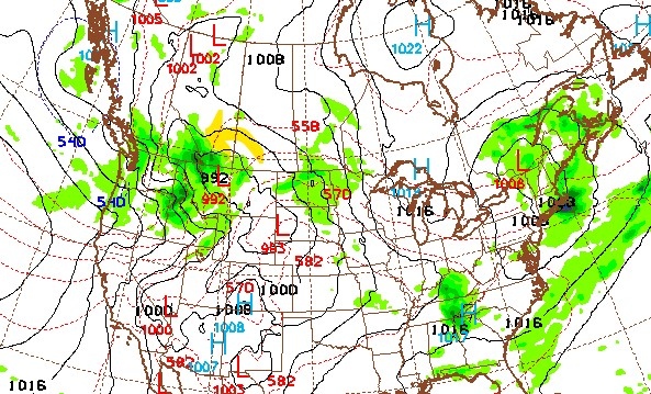
The weather charting here is the forecast valid Monday 6 a.m. MST. Apologies for the shoddily-drawn yellow arrow, but that band of moisture would be curling back over parts of southern Alberta. There are still a number of variables to this: when lows cross the Rockies, where do they drop in? How fast will it move, and how much precipitation will be embedded? These factors mean you'll see models suggesting Calgary could see 95.3 millimetres (no, really, that's what the 4-6 day GDPS says!) while others say six millimetres. It's tough to build a reliable, long-range precipitation model against the Rockies. We'll have a better idea this weekend. If I have to lean somewhere, it's 15-20 millimetres. Parts of Alberta will likely receive heavy showers.
MORNING EDITION: A slight chance for rain remains on Saturday in the afternoon, but if we can use the past to predict the future, it's a small enough chance that it'll be gone 48 hours from now.
I digress.
This has been a very, very strange week weather-wise, if only for what has, and has not happened yet. First, we had Sunday. That was the wettest day of the year. 10.9 millimetres. Then, Monday, we achieved a new wettest day of the year, with 24.2 millimetres of rain.
Yesterday, Calgary Weather Records made this note:
Today, the tilt from the upper jet will push in gusty conditions, with 30-40 km/h gusts locally. The projected high is 24 C, thus breaking the 2022 warmest day record.
So in the span of five days, we'll have achieved the two wettest consecutive days of the year, followed by the two warmest consecutive days of the year.
You go, Calgary.
Showers Saturday would be a sprinkle, if they happened. There's also a chance for a later-afternoon thundershower, but we can likely put that to bed by tomorrow, all patterns playing out as they usually do. Sunday evening may herald the start of some rainshowers locally.
Monday (and Tuesday) remain rainy, with a large lee low expected to cross through Montana. Depending on where exactly this takes place, another large quantity of rainfall could be on the way for parts of southern Alberta.
YOUR FIVE-DAY CALGARY FORECAST:
Thursday
- Evening: some cloud, low 12 C
Friday
- Mainly sunny
- Daytime high: 25 C
- Evening: mainly cloudy, low 13 C
Saturday
- Partly cloudy, chance of afternoon showers, isolated thundershowers
- Daytime high: 23 C
- Evening: mostly clear, low 8 C
Sunday
- Partly cloudy, scattered afternoon showers
- Daytime high: 18 C
- Evening: cloudy, chance of showers low 8 C
Monday
- Rain - 20+mm possible
- Daytime high: 15 C
- Evening: cloudy, showers, low 8 C
Tuesday
- Cloudy, showers
- Daytime high: 16 C
- Evening: cloudy, chance of showers, low 8 C
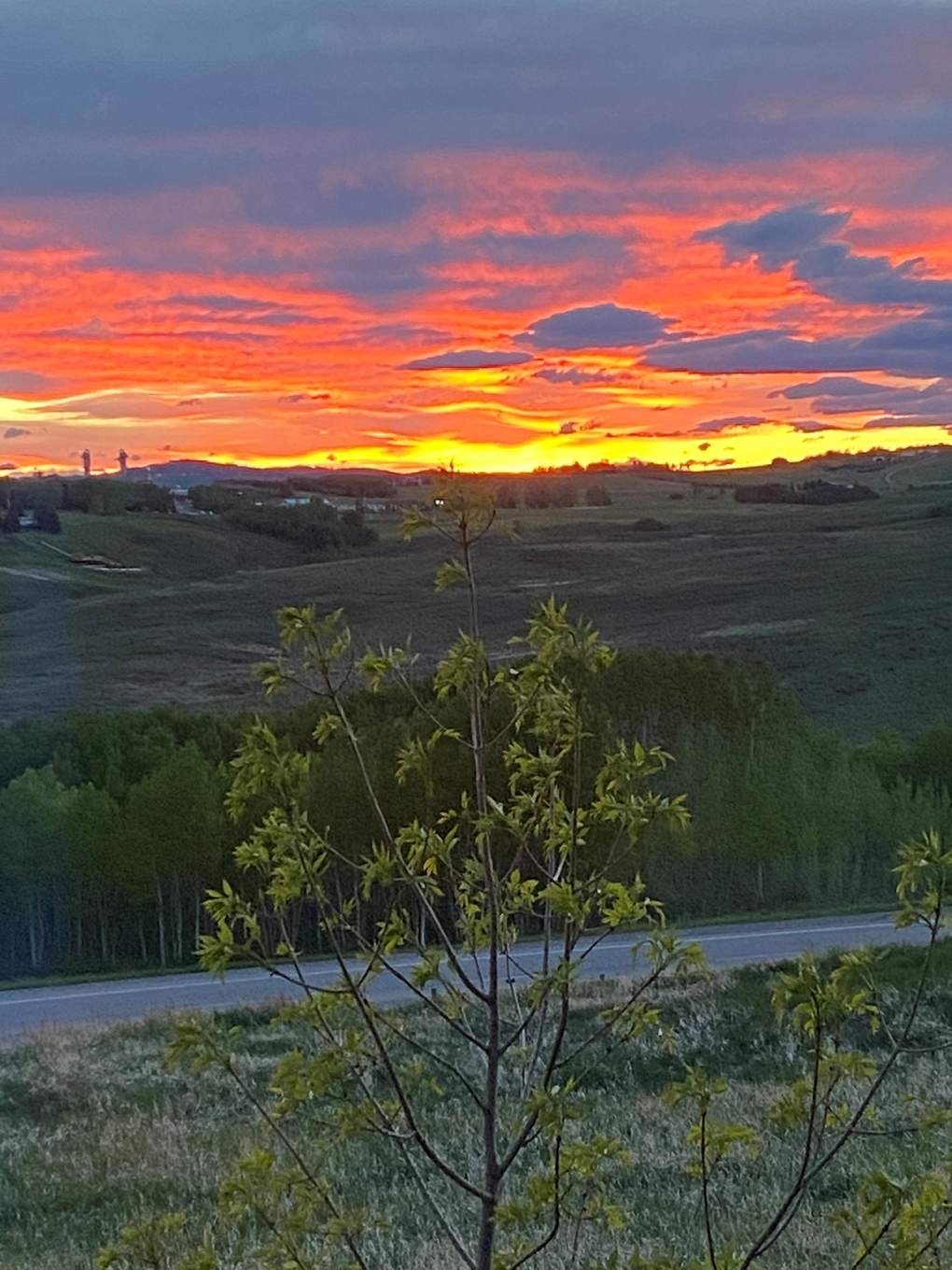
Today's pic was sent by Jeff of the magnificent sunset yesterday from his vantage in Cochrane.
Submit your weather photos here to see them featured in our article, and perhaps even as the pic of the day during our News at Six! You can also share my way on Twitter, or to our Instagram at @CTVCalgaryWeather.


CTVNews.ca Top Stories
How quietly promised law changes in the 2024 federal budget could impact your day-to-day life
The 2024 federal budget released last week includes numerous big spending promises that have garnered headlines. But, tucked into the 416-page document are also series of smaller items, such as promising to amend the law regarding infant formula and to force banks to label government rebates, that you may have missed.
Which foods have the most plastics? You may be surprised
'How much plastic will you have for dinner, sir? And you, ma'am?' While that may seem like a line from a satirical skit on Saturday Night Live, research is showing it's much too close to reality.
opinion
opinion I've been a criminal attorney for decades. Here's what I think about the case against Trump
Joey Jackson, a criminal defence attorney and a legal analyst for CNN, outlines what he thinks about the criminal case against Donald Trump in the 'hush money trial.'
$3.8M home in B.C.'s Okanagan has steel shell for extra wildfire protection
A home in B.C.'s Okanagan that features a weathering steel shell designed to provide some protection against wildfires has been listed for sale at $3.8 million.
Diver pinned under water by an alligator figured he had choice. Lose his arm or lose his life
An alligator attacked a diver on April 15 as he surfaced from his dive, nearly out of air. His tank emptied with the gator's jaws crushing the arm he put up in defence.
Psychologist becomes first person in Peru to die by euthanasia after fighting in court for years
A Peruvian psychologist who suffered from an incurable disease that weakened her muscles and had her confined to her bed for several years, died by euthanasia, her lawyer said Monday, becoming the first person in the country to obtain the right to die with medical assistance.
Mystery surrounds giant custom Canucks jerseys worn by Lions Gate Bridge statues
The giant stone statues guarding the Lions Gate Bridge have been dressed in custom Vancouver Canucks jerseys as the NHL playoffs get underway.
Celebrity designer sentenced to 18 months in prison for smuggling crocodile handbags
A leading fashion designer whose accessories were used by celebrities from Britney Spears to the cast of the 'Sex and the City' TV series was sentenced Monday to 18 months in prison after pleading guilty in Miami federal court on charges of smuggling crocodile handbags from her native Colombia.
Wildfire leads to evacuation order issued for northeast Alberta community
An evacuation order was issued on Monday afternoon for homes in the area of Cold Lake First Nation.
Shopping Trends
The Shopping Trends team is independent of the journalists at CTV News. We may earn a commission when you use our links to shop. Read about us.


Edmonton
-
Fire engulfs old Edmonton municipal airport hangar
A historical hangar at the former Edmonton municipal airport beside the NAIT main campus was on fire Monday night.
-
Wildfire leads to evacuation order issued for northeast Alberta community
An evacuation order was issued on Monday afternoon for homes in the area of Cold Lake First Nation.
-
Province announces changes to lower utility bills in Calgary, but no relief for Edmonton customers
The Alberta government is changing existing legislation to lower utility bills in Calgary.
Lethbridge
-
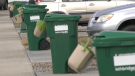
Lethbridge green cart program a success one year in, city says
The City of Lethbridge is calling the first year of its curbside organics waste collection program a success.
-
Coaldale RCMP seek information on hit-and-run
Coaldale RCMP are looking for the public's help to locate a suspect in a hit-and-run in a McDonald's parking lot earlier this month.
-
Deal to protect ranch from development means family can keep raising cattle there
An agreement to protect a sprawling ranch in southern Alberta from development is the largest of its kind in the country, the Nature Conservancy of Canada says, and will allow the family that owns it to continue raising cattle there.
Vancouver
-

More than firefighters: B.C. chief urges home preparation for wildfire season
As the wildfire season ramps up and a pair of evacuation alerts are now in place, one of British Columbia’s top fire officials is making a personal appeal to the public to take some simple steps that could safeguard their homes.
-
Mystery surrounds giant custom Canucks jerseys worn by Lions Gate Bridge statues
The giant stone statues guarding the Lions Gate Bridge have been dressed in custom Vancouver Canucks jerseys as the NHL playoffs get underway.
-
Calls grow louder for changes to decriminalization in B.C.
Backlash to decriminalization dominated question period Monday in the B.C. legislature, with the Official Opposition BC United and BC Conservatives calling for the province to end the three-year pilot project.
Vancouver Island
-
Police release details about suspect vehicle after fatal B.C. hit-and-run crash
Mounties searching for a driver who struck and killed a woman on Vancouver Island last week released new details about the suspect vehicle Monday.
-
Search for missing kayakers off Vancouver Island expands into U.S.
Authorities on both sides of the Canada-U.S. border resumed search efforts Monday to find two men who went missing while kayaking off Vancouver Island over the weekend.
-
'Historic' law recognizing Haida Aboriginal title introduced in B.C. legislature
The B.C. government says legislation formally recognizing the Haida Nation's Aboriginal title over Haida Gwaii was introduced in the legislature Monday.
Saskatoon
-

Sask. broker says halal mortgages are not a new concept in Canada
A Saskatoon mortgage broker says the federal government’s move to help Muslim Canadians get into the housing market by promoting halal mortgages is not such a radical idea — it’s helping families buy their first home without breaking their faith.
-
Sask. driver caught using vice grips in place of steering wheel
A driver caught using vice grips in place of a steering wheel was ticketed Wednesday after being stopped by police on a rural road.
-
Saskatchewan Rush look to 'better mentality next year' as they miss playoffs again
The Saskatchewan Rush are absent from the National Lacrosse League playoffs for a third straight season, a difficult end to an postseason push born out of a rocky start.
Regina
-

Sask. NDP leader combats claims of carbon tax support following Ottawa visit
Members of the Sask. Party claim a recent trip by the leader of the opposition reveals her party's secret support for the federal carbon tax.
-
Sask. NDP call for education minister's firing, premier reconfirms confidence
The Saskatchewan NDP are calling for the resignation or firing of Education Minister Jeremy Cockrill, saying he lied about apologizing for comments he made to a mother whose daughter died.
-
'Living side by side': Governor General Mary Simon makes first official visit to Saskatchewan
Canada’s Governor General made her first official visit to Saskatchewan Monday.
Toronto
-

Matthews scores winner in the third, Maple Leafs down Bruins 3-2 to even series 1-1
Auston Matthews scored the winner in the third period and added two assists as the Toronto Maple Leafs topped the Boston Bruins 3-2 on Monday to even their first-round playoff series 1-1.
-
Toronto police chief asks for OPP review after judge in Umar Zameer trial raised concerns about officer testimony
Toronto’s police chief has ordered a “full internal review of all aspects of plainclothes policing” following an acquittal in the first-degree murder trial of Umar Zameer.
-
Some of gold stolen during airport heist was melted down in basement of GTA jewelry store: police
At least some of the gold bars stolen during the heist at Pearson Airport one year ago was likely melted down in the basement of a Toronto area jewelry store, Peel police tell CP24.com.
Montreal
-

Suspects crash into Montreal police cars three times in one day
A police officer was injured Monday in one of three incidents of drivers crashing their vehicles into a patrol car, Montreal police said.
-
Quebec Health Department reports 28 cases of eye damage linked to solar eclipse
Quebec's Health Department says it has received 28 reports of eye damage related to the April 8 total solar eclipse that passed over southern parts of the province.
-
French-only greetings drop in Montreal as 'bonjour, hi' gains popularity
Most Montreal merchants greet their customers in French only, but that could soon change as "bonjour, hi" becomes more popular.
Atlantic
-

Youth dead after incident near Halifax Shopping Centre: police
A male youth is dead after an incident near the Halifax Shopping Centre on Monday.
-
Woman airlifted to hospital after N.S. car crash
Three people are in hospital with serious injuries after a two-vehicle crash in New Germany, N.S., on Sunday.
-
Posters promoting theft from Loblaws circulate online
Pictures of a poster encouraging people to steal from Loblaw Companies Limited next month on a specific date have been circulating online.
Winnipeg
-
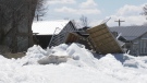
'Never seen this before': Homes in Manitoba community damaged by ice wall
Homeowners in a Manitoba community are cleaning up after being impacted by a natural phenomenon last week.
-
'It's bittersweet': Popular St. Boniface restaurant set to close its doors
Marion Street Eatery is set to close its doors for good after over a decade serving up steaming plates of eggs benedict, grilled cheese and brisket hash.
-
Manitoba could soon end ban of growing recreational cannabis at home
People in Manitoba could soon be able to grow recreational cannabis in their homes.
Ottawa
-
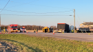
3 children injured after truck and school bus collide in Russell, Ont.
Three children and a driver were taken to hospital after a school bus and a truck collided on Route 400 in Russell, Ont.
-
Ottawa police hate crime unit investigating chants made at pro-Palestinian rally Saturday
The Ottawa Police Service is investigating comments made at a pro-Palestinian rally on Saturday that have received condemnation by federal leaders, including Prime Minister Justin Trudeau.
-
Poker game underway at time of fatal Manor Park shooting: police chief
Kevin Willington, 53, of Ottawa has been identified as the victim of a shooting at a home on Birch Avenue on Friday night. Ottawa police said officers responded to a call for a shooting, and the victim died from his injuries at the scene.
Northern Ontario
-

Man responsible for northern Ont. crash that killed woman days before her wedding fined $5K
It was a sad scene at Tom Davies Square in Sudbury on Monday morning, where a man was being sentenced for a crash that killed a North Bay woman who was driving to her wedding shower.
-
WATCH
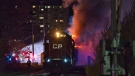
WATCH 'I couldn't believe it': Freight train on fire rolls through downtown London, Ont.
The investigation into how a train moving through the City of London caught fire has been turned over to the CP Rail police. Just before 11 p.m. on Sunday, London fire received multiple 911 calls about an eastbound train on fire, crossing over Oxford Street.
-
Sudbury police say suspect exposed themselves, asked youth for sexual favours on local trail
Police officials in Sudbury say they received a complaint that a youth was approached by an individual asking for sexual favours and exposing himself on a city walking trail.
Barrie
-
Wrong-way driver on highway 11 causes collision with transport truck
Huntsville OPP charged a driver for going the wrong way on Highway 11 and colliding with a transport vehicle.
-
Sexual assault at Barrie hotel under investigation
The Barrie Police Service Human Trafficking Unit were called after a woman was allegedly assaulted by a man she had met through a texting app.
-
Destructive fire engulfs barn in Springwater
A destructive fire broke out in a barn on Monday afternoon at Flos Rd 8 in Springwater.
Kitchener
-

Man knows who has stolen laptop but can't get it back
A Kitchener man who forgot his laptop on a bus in January says he’s now being asked to pay $750 to get it back from whoever has the device.
-
Suspect in Brantford double shooting knocked on stranger’s door to turn himself in
Brantford police say one person remains in critical condition after a shooting in Brantford Sunday night.
-
Flair flight cancellation leaves Guelph traveller stranded, uninformed
Andrew Mackay from Guelph says he was left stranded in Florida last year after his flight with Flair Airlines was cancelled without his knowledge.
London
-
 WATCH
WATCHWATCH 'I couldn't believe it': Freight train on fire rolls through downtown London, Ont.
The investigation into how a train moving through the City of London caught fire has been turned over to the CP Rail police. Just before 11 p.m. on Sunday, London fire received multiple 911 calls about an eastbound train on fire, crossing over Oxford Street.
-
Political push for more consultation with LTC before green lighting free bus pass pilot project for high schoolers
A pair of city councillors want a feasibility study completed before deciding the location and parameters of a pilot project to provide free bus passes to high school students.
-
London man pleads guilty after random stabbing
A man charged with stabbing a driver several times pleaded guilty to the incident Monday in a London, Ont. courtroom.
Windsor
-

New lighting being installed along Windsor’s riverfront
The City of Windsor Parks Department will be working on improvements to a couple of Windsor parks over the next few weeks, including more lights on the riverfront.
-
City of Windsor workers want higher wages and remote work flexibility: Report
City employees are not being compensated fairly and want more flexibility to work from home, according to the head of the union representing more than 1,300 City of Windsor workers.
-
Public feedback wanted for Windsor truck route study
The City of Windsor is moving into the third phase of its truck route study in an ongoing effort to help modernize and update the truck route network to adapt to changing city requirements.


