A chilly start to February in Calgary heralds warmth this weekend
Snowfall warnings continue through the Peace River Valley, along with a new expansion of the extreme cold warned zone to cap off the movement of this large, cold, high-pressure region.
As that dives in today, we’ll watch for a late-morning high, followed by building cold and potential production of light snow; snowfall totals of one to two centimetres have fallen further away (skiff conditions), in the wake of the system's trajectory shifting more eastward and less southward. This won't affect our temperatures, however, which remain quite cool overnight.
In spite of the coming overnight low temperature, Thursday will make for a hasty recovery-day, popping us back toward seasonal in an awful big hurry, before we enter a west-wind setup aloft through the weekend and produce benign, fair-weather conditions that exceed seasonal normal temperatures all over again.
Conditions thereafter look fairly similar; we’re starting February in a comparative vein to the offerings of December and January.
YOUR FIVE-DAY CALGARY FORECAST
Wednesday
- Evening: cloudy, flurries, low -17 C
Thursday
- Partly cloudy, early scattered flurries
- Daytime high: -3 C
- Evening: mainly clear, low -5 C
Friday
- Partly cloudy
- Daytime high: 5 C
- Evening: some cloud, low -7 C
Saturday
- Sunny
- Daytime high: 6 C
- Evening: clear, low -2 C
Sunday
- Partly cloudy
- Daytime high: 5 C
- Evening: mainly clear, low -2 C
Monday
- Mainly sunny
- Daytime high: 5 C
- Evening: mainly clear, low -3 C
RJ Da Roza sent this great pic over that he took on the weekend:
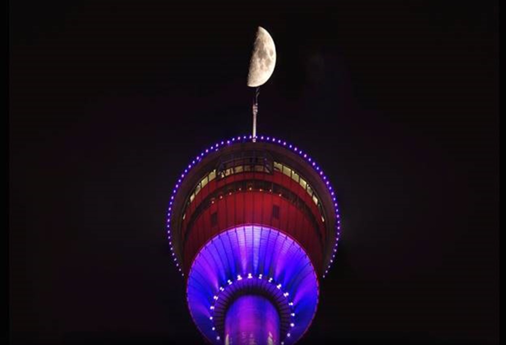 Viewer RJ Da Rozsa captured this shot of the moon and the Calgary Tower.
Submit your weather photos here to see them featured in our article, and perhaps even as the pic of the day during our News at Six! You can also share on Twitter, or to our Instagram at @CTVCalgaryWeather.
CTVNews.ca Top Stories

Nearly half of China's major cities are sinking, researchers say
Nearly half of China's major cities are suffering 'moderate to severe' levels of subsidence, putting millions at risk of flooding especially as sea levels rise.
American millionaire Jonathan Lehrer denied bail after being charged with killing Canadian couple
American millionaire Jonathan Lehrer, one of two men charged in the killings of a Canadian couple in Dominica, has been denied bail.
Prince Harry formally confirms he is now a U.S. resident
Prince Harry, the son of King Charles III and fifth in line to the British throne, has formally confirmed he is now a U.S. resident.
Judge says 'no evidence fully supports' murder case against Umar Zameer as jury starts deliberations
The judge presiding over the trial of a man accused of fatally running over a Toronto police officer is telling jurors the possible verdicts they may reach based on the evidence in the case.
Sports columnist apologizes for 'oafish' comments directed at Caitlin Clark. The controversy isn't over
A male columnist has apologized for a cringeworthy moment during former University of Iowa superstar and college basketball's highest scorer Caitlin Clark's first news conference as an Indiana Fever player.
Health Canada to change sperm donor screening rules for men who have sex with men
Health Canada will change its longstanding policy restricting gay and bisexual men from donating to sperm banks in Canada, CTV News has learned. The federal health agency has adopted a revised directive removing the ban on gay, bisexual and other men who have sex with men, effective May 8.
Colin Jost names one celebrity who is great at hosting 'Saturday Night Live'
Colin Jost, who co-anchors Saturday Night Live's 'Weekend Update,' revealed who he thinks is one of the best hosts on the show.
'Shopaholic' author Sophie Kinsella reveals brain cancer diagnosis
Sophie Kinsella, the best-selling author behind the 'Shopaholic' book series, has revealed that she is receiving treatment for brain cancer.
LeBlanc says he plans to run in next election, under Trudeau's leadership
Cabinet minister Dominic LeBlanc says he plans to run in the next election as a candidate under Prime Minister Justin Trudeau's leadership, amid questions about his rumoured interest in succeeding his longtime friend for the top job.


