Another mild day in Calgary, then things improve…again!
CALGARY -
If you're a regular reader, first off, thank you! Secondly, you might recognize that headline from yesterday's article. That's a by-product of our current conditions. Yesterday's gentle sprinklings have moved along with our upper low, and thus we have only two effects remaining from its passage; wind, and cloud.
Today's wind totals will remain largely stabilized in the 20 km/h range, and today's cloud cover is mixed; we'll still see sunshine. However, these components will keep us from seasonal temperatures once again.
After another brisk start tomorrow, a ridge of high pressure will work through and send us toward the mid-twenties into the Labour Day weekend. The ridge begins to fade Monday, but then experiences a renaissance from the trailing high pressure ridge – that is to say, the longer-range outlook is forecasting highs in the mid-twenties by this time next week.
Here's hoping, for those of you who don't want summer to end!
As a small reminder: Autumn's astronomical start is on the equinox, which is Sept. 22 (equi = equal, nox = night). Autumn's meteorological start begins with the flip of the calendar into September
YOUR FIVE-DAY FORECAST
Today:
- Partly cloudy
- Daytime high: 16 C
- Evening: some cloud, low 6 C
Friday:
- Sunny
- Daytime high: 20 C
- Evening: clear, low 7 C
Saturday:
- Partly cloudy
- Daytime high: 24 C
- Evening: clear, low 11 C
Sunday:
- Mainly sunny
- Daytime high: 25 C
- Evening: clear, low 11 C
Monday:
- Partly cloudy
- Daytime high: 20 C
- Evening: some cloud, low 9 C
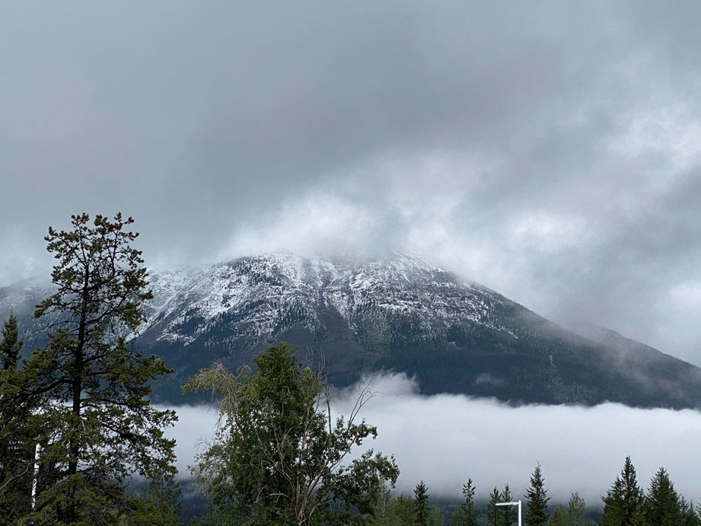
Our photo of the day comes to us from Steve in Jasper. Jasper. Yes, our mountains have some capping, too, but nothing like his!
Also, from CTV’s Teri Fikowski, this amazing shot of the city at sunrise today!
You can submit your photos here, email me directly here, or tweet them over!


CTVNews.ca Top Stories

Young people 'tortured' if stolen vehicle operations fail, Montreal police tell MPs
One day after a Montreal police officer fired gunshots at a suspect in a stolen vehicle, senior officers were telling parliamentarians that organized crime groups are recruiting people as young as 15 in the city to steal cars so that they can be shipped overseas.
'It was joy': Trapped B.C. orca calf eats seal meat, putting rescue on hold
A rescue operation for an orca calf trapped in a remote tidal lagoon off Vancouver Island has been put on hold after it started eating seal meat thrown in the water for what is believed to be the first time.
Man sets self on fire outside New York court where Trump trial underway
A man set himself on fire on Friday outside the New York courthouse where Donald Trump's historic hush-money trial was taking place as jury selection wrapped up, but officials said he did not appear to have been targeting Trump.
Sask. father found guilty of withholding daughter to prevent her from getting COVID-19 vaccine
Michael Gordon Jackson, a Saskatchewan man accused of abducting his daughter to prevent her from getting a COVID-19 vaccine, has been found guilty for contravention of a custody order.
Mandisa, Grammy award-winning 'American Idol' alum, dead at 47
Soulful gospel artist Mandisa, a Grammy-winning singer who got her start as a contestant on 'American Idol' in 2006, has died, according to a statement on her verified social media. She was 47.
She set out to find a husband in a year. Then she matched with a guy on a dating app on the other side of the world
Scottish comedian Samantha Hannah was working on a comedy show about finding a husband when Toby Hunter came into her life. What happened next surprised them both.
B.C. judge orders shared dog custody for exes who both 'clearly love Stella'
In a first-of-its-kind ruling, a B.C. judge has awarded a former couple joint custody of their dog.
Saskatoon police to search landfill for remains of woman missing since 2020
Saskatoon police say they will begin searching the city’s landfill for the remains of Mackenzie Lee Trottier, who has been missing for more than three years.
Shivering for health: The myths and truths of ice baths explained
In a climate of social media-endorsed wellness rituals, plunging into cold water has promised to aid muscle recovery, enhance mental health and support immune system function. But the evidence of such benefits sits on thin ice, according to researchers.
Shopping Trends
The Shopping Trends team is independent of the journalists at CTV News. We may earn a commission when you use our links to shop. Read about us.


Edmonton
-

Spit, punches and bites: School support staff detail rising violence from students
A former educational assistant is calling attention to the rising violence in Alberta's classrooms.
-
Grande Prairie swears in new police chief as questions swirl over need for an Alberta force
The city's transition to governing its own police force comes as Alberta's public safety minister cites concerns with the province's policing contract with the RCMP, which expires in 2032.
-
'My family’s life was shattered': Daughter of Edmonton couple killed by impaired driver speaks at sentencing
Family and friends of an Edmonton couple killed in an impaired driving crash packed into a courtroom for the sentencing hearing Friday.
Lethbridge
-
Lethbridge cutting back on water use as part of provincial water sharing agreement
The province has announced the largest water sharing agreement in Alberta’s history, which will see Lethbridge and Medicine Hat, among other municipalities, cut water use.
-
Medicine Hat woman charged after $60K stolen from Redcliff Legion
Mounties say a 32-year-old Medicine Hat woman has been charged in connection with the theft of $60,000 from the Redcliff Legion.
-
Deterrent sentence possible, expert says, after trio convicted in connection to Coutts border blockade
Three men who helped lead and co-ordinate the 2022 border blockade at Coutts, Alta., have been found guilty of public mischief.
Vancouver
-

B.C. judge orders shared dog custody for exes who both 'clearly love Stella'
In a first-of-its-kind ruling, a B.C. judge has awarded a former couple joint custody of their dog.
-
Vancouver nurse, union say concerns over drug use in hospitals politicized
A Vancouver nurse is speaking out, saying politicians are using recent accounts of concerns related to the safety of health-care workers for political gain.
-
Dead deer, loaded guns, booze: Warrant for 4th man in B.C. poaching case
An advocacy group for hunters is calling for increased funding to the B.C. Conservation Officer Service, as authorities pledge to find a fourth man wanted in connection with a “disgusting” poaching case.
Vancouver Island
-

'It was joy': Trapped B.C. orca calf eats seal meat, putting rescue on hold
A rescue operation for an orca calf trapped in a remote tidal lagoon off Vancouver Island has been put on hold after it started eating seal meat thrown in the water for what is believed to be the first time.
-
B.C. Humanist Association threatens to sue Vancouver Island city over council prayer
The B.C. Humanist Association has announced plans to sue a Vancouver Island city for breaching religious neutrality by including a Christian prayer in council.
-
After breaking world records and training movie stars, B.C. free diver becomes police dispatcher
For as long as Mandy-Rae Krack can recall, the water has inspired wonder.
Saskatoon
-

‘My family are all broken-hearted’: Grandfather of homicide victim speaks out
Saskatoon is grappling with the tragic death of 24-year-old Melissa Duquette, whose body was discovered on April 15. A day later, authorities confirmed her death as a homicide, sparking deep sorrow and calls for action within the community.
-
Saskatoon judge to make ruling on evidence in fatal THC-impaired driving case
A Saskatoon Provincial Court judge will determine whether testimony from a woman, charged with impaired driving causing the death of a child, will be used as evidence in her trial.
-
Sask. Teachers' Federation sending offer to a vote 'tactical move': labour scholar
Teachers have three weeks to consider how they’ll vote on an offer from the provincial bargaining committee. But where does the dispute go next?
Regina
-

Sask. father found guilty of withholding daughter to prevent her from getting COVID-19 vaccine
Michael Gordon Jackson, a Saskatchewan man accused of abducting his daughter to prevent her from getting a COVID-19 vaccine, has been found guilty for contravention of a custody order.
-
Sask. Teachers' Federation sending offer to a vote 'tactical move': labour scholar
Teachers have three weeks to consider how they’ll vote on an offer from the provincial bargaining committee. But where does the dispute go next?
-
Saskatoon police to search landfill for remains of woman missing since 2020
Saskatoon police say they will begin searching the city’s landfill for the remains of Mackenzie Lee Trottier, who has been missing for more than three years.
Toronto
-

Ontario early childhood educators still waiting for promised 2024 wage increases
Ontario Registered Early Childhood Educators (RECEs) are still waiting for their promised 2024 wage increases and advocates say the delay is causing stress for workers.
-
U.S. FAA launches investigation into unauthorized personnel in cockpit of Colorado Rockies flight to Toronto
The U.S.’s Federal Aviation Administration is investigating a video that appears to show unauthorized personnel in the cockpit of a charted Colorado Rockies flight to Toronto.
-
WATCH
WATCH Video shows dramatic police takedown of carjacking suspects chased through parking lot north of Toronto
Police have released video footage of a dramatic takedown of a group of teens wanted in connection with an attempted carjacking in Markham earlier this month.
Montreal
-
Young people 'tortured' if stolen vehicle operations fail, Montreal police tell MPs
One day after a Montreal police officer fired gunshots at a suspect in a stolen vehicle, senior officers were telling parliamentarians that organized crime groups are recruiting people as young as 15 in the city to steal cars so that they can be shipped overseas.
-
Woman stabbed at motel in Montreal's west end
A 39-year-old woman was sent to hospital with serious injuries after police say she was stabbed inside a motel room in Montreal's west end Friday morning.
-
Iconic ninth floor Eaton Centre restaurant set to reopen in May
There was once a beautiful restaurant on the ninth floor of the former Eaton's department store. It closed 25 years ago, but many in Montreal still talk about it. Soon, Le 9ieme will open to diners once again.
Atlantic
-

Nova Scotia justice minister resigns following domestic violence comments
Nova Scotia Justice Minister Brad Johns has resigned, according to a short statement from Premier Tim Houston on Friday evening.
-
Lyrid meteor shower nears peak; viewing opportunities in the Maritimes
CTV Atlantic meteorologist Kalin Mitchell says a large part of the Maritimes should have ideal viewing conditions for the Lyrid meteor shower Sunday overnight into Monday morning.
-
N.B. Environment Minister Gary Crossman resigns, says political beliefs 'no longer align' with Higgs’ government
Gary Crossman, New Brunswick’s minister of environment and climate change, has resigned from Blaine Higgs’ Progressive Conservative cabinet effective immediately.
Winnipeg
-

'Like part of the family': St. Boniface burger staple back after closing down last year
Mrs. Mikes shut down last year after a half-century of serving the community. Now its doors have reopened and Winnipeggers were lined up to get their fill, even as snow fell on them.
-
Winnipeg airport's longest runway is getting a facelift
The Winnipeg Airports Authority is doing an extensive repaving project to its largest runway.
-
Manitoba mom praises quick-thinking fire department for freeing daughter stuck in playground equipment
A Manitoba mother is praising firefighters for their quick work in helping her daughter who got stuck at a playground in Lorette, Man.
Ottawa
-

Tenants fighting proposed redevelopment in Centretown
As the City of Ottawa faces a housing shortage, there is controversy brewing in Centretown over a proposed redevelopment that many tenants say could leave them homeless.
-
Tropical fish stolen from Beachburg, Ont. restaurant found and returned
Ontario Provincial Police have landed a suspect following a fishy theft in Beachburg, Ont.
-
Will parking remain free in Wellington West and Westboro? City studying parking options
Time could soon run out on free on-street parking in Ottawa's Westboro, Wellington West and Hintonburg neighbourhoods.
Northern Ontario
-
Vicious attack on a dog ends with charges for northern Ont. suspect
Police in Sault Ste. Marie charged a 22-year-old man with animal cruelty following an attack on a dog Thursday morning.
-
Man sets self on fire outside New York court where Trump trial underway
A man set himself on fire on Friday outside the New York courthouse where Donald Trump's historic hush-money trial was taking place as jury selection wrapped up, but officials said he did not appear to have been targeting Trump.
-
Flood warning issued for Lake Nipissing shoreline in North Bay
A flood warning was issued Friday for the Lake Nipissing shoreline in North Bay, Callander and the Parks Creek watershed.
Barrie
-
Driver charged after Highway 400 crash sends woman and child to hospital
One person has been charged following a collision on Highway 400 in Barrie Friday morning that sent a vehicle rolling into a ditch.
-
Barrie pharmacy launches 1st provincial pharmacist care walk-in clinic
The first provincial pharmacist care walk-in clinic has opened at the Rexall in the north end of Barrie to provide more immediate care for minor illnesses and chronic care in a more private setting.
-
Break-in leaves Barrie home with considerable water damage
Police are hoping to identify the person(s) who allegedly broke into a Barrie home and caused extensive water damage.
Kitchener
-

NDP leader likens Wilmot farmland grab to Greenbelt scandal
A controversial land acquisition proposed in Wilmot Township is once again in the spotlight, as Ontario NDP leader Marit Stiles hosts a town hall in the community, calling the deal “eerily similar” to the Greenbelt scandal.
-
'I'm still shaking': Emotional victim impact statements shared after impaired double-fatal crash in Cambridge
It was an emotional day in court as close to a dozen people read victim impact statements to the man charged with impaired driving in a double-fatal Cambridge crash.
-
Kitchener golfer recognized as creator of Masters skip-shot tradition
A Canadian Hall of Fame golfer from Kitchener is finally getting recognition for starting the skip-shot tradition at The Masters.
London
-

No more train trauma for Adelaide Street commuters
‘Onto Adelaide and just zip down’: Cars no longer have to deal with trains on Adelaide Street North, near Central Avenue.
-
Witness insists they are telling the truth at sexual abuse trial
A witness at the sexual assault trial involving parents is adamant the children involved in the trial are all telling the truth about what they had to endure during their upbringing.
-
City councillor says encampment response falls short and comes too late
A city councillor said she’s concerned the city is encouraging homeless encampments rather than finding more permanent solutions.
Windsor
-

'My family’s suffering still hasn’t ended': Faint hope hearing evidence concludes with victim impact statements
A Windsor man convicted in a violent murder 20 years ago awaits ruling on bid for early parole.
-
Body recovered from Detroit River
An investigation is underway after a body was pulled from the Detroit River.
-
One driver charged, one sought after crash at apparent 'unsanctioned' rally
Windsor police have charged a 21-year-old man with stunt driving following a collision at a commercial property.


