Blowing snow and blizzard-like conditions Monday morning

A return to wintry weather kicks off the new week. A cold front sweeps southeast across the province Sunday night bringing gusty winds and snow to central Alberta by Monday morning.
Blowing snow is likely to reduce visibility to near zero as northerly winds gust to 70-90 km/h. General snowfall could reach 5-10 cm across central and southern Alberta, while the foothills could see more than 10 cm due to upslope flow.
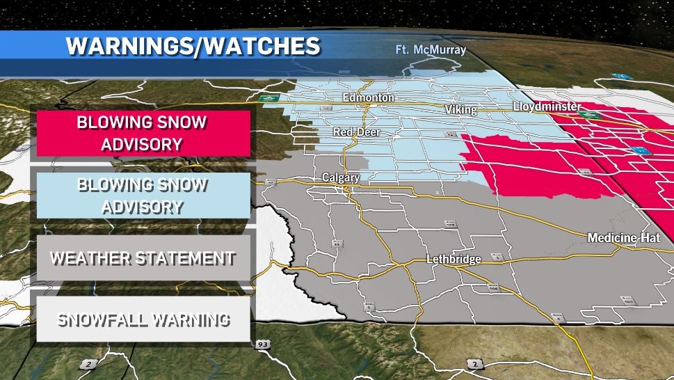
However, accumulation in central and southern regions may be limited thanks to milder weather over the last week keeping ground temperatures warm.
Wind speeds diminish Monday evening as snow tapers off in central Alberta, but lingers over the foothills and swings further east Tuesday morning.

Temperatures steadily fall through the first half of the week and bottoms out by early Wednesday morning in the minus 20s.
Here’s the five day:
Monday:
- Morning flurries, gusty wind at times, N 50g70 km/h
- Daytime high: 0 C, afternoon temperature falls to near -9 C
- Overnight: Chance of flurries, - 13 C
Tuesday:
- Periods of light snow
- Daytime high: -13 C, afternoon temperature falls to -17 C
- Overnight: Clearing, -23 C
Wednesday:
- Sun and cloud mixed
- Daytime high: -15 C
- Overnight: Mostly cloudy, warming up overnight, -17 C
Thursday:
- Partly cloudy
- Daytime high: -1 C
- Overnight: Mostly cloudy, -4 C
Friday:
- Sun and cloud mixed
- Daytime high: 5 C
- Overnight: Partly cloudy, -2 C


CTVNews.ca Top Stories

Doctors say capital gains tax changes will jeopardize their retirement. Is that true?
The Canadian Medical Association asserts the Liberals' proposed changes to capital gains taxation will put doctors' retirement savings in jeopardy, but some financial experts insist incorporated professionals are not as doomed as they say they are.
Something in the water? Canadian family latest to spot elusive 'Loch Ness Monster'
For centuries, people have wondered what, if anything, might be lurking beneath the surface of Loch Ness in Scotland. When Canadian couple Parry Malm and Shannon Wiseman visited the Scottish highlands earlier this month with their two children, they didn’t expect to become part of the mystery.
Fair in Ontario, flurries in Labrador: Weather systems make for an erratic spring
It's no secret that spring can be a tumultuous time for Canadian weather, and as an unseasonably mild El Nino winter gives way to summer, there's bound to be a few swings in temperature that seem out of the ordinary. From Ontario to the Atlantic, though, this week is about to feel a little erratic.
What do weight loss drugs mean for a diet industry built on eating less and exercising more?
Recent injected drugs like Wegovy and its predecessor, the diabetes medication Ozempic, are reshaping the health and fitness industries.
He replaced Mickey Mantle. Now baseball's oldest living major leaguer is turning 100
The oldest living former major leaguer, Art Schallock turns 100 on Thursday and is being celebrated in the Bay Area and beyond as the milestone approaches.
What a urologist wants you to know about male infertility
When opposite sex couples are trying and failing to get pregnant, the attention often focuses on the woman. That’s not always the case.
'It was instant karma': Viral video captures failed theft attempt in Nanaimo, B.C.
Mounties in Nanaimo, B.C., say two late-night revellers are lucky their allegedly drunken antics weren't reported to police after security cameras captured the men trying to steal a heavy sign from a downtown business.
Bank of Canada officials split on when to start cutting interest rates
Members of the Bank of Canada's governing council were split on how long the central bank should wait before it starts cutting interest rates when they met earlier this month.
Quebec nurse had to clean up after husband's death in Montreal hospital
On a night she should have been mourning, a nurse from Quebec's Laurentians region says she was forced to clean up her husband after he died at a hospital in Montreal.
Shopping Trends
The Shopping Trends team is independent of the journalists at CTV News. We may earn a commission when you use our links to shop. Read about us.


Edmonton
-

Nurse practitioners to make 80% as much as family doctors for publicly-funded primary care
The Alberta government says it will pay nurse practitioners 80 per cent of what family doctors are paid – if they want to practice comprehensive primary care.
-
MacTavish on Oilers-Kings Game 2: 'It's going to be a completely different game'
Former Oilers player, coach and general manager Craig MacTavish talks to CTV News Edmonton's Matt Woodman about playoff hockey and Game 2 between Edmonton and Los Angeles.
-
Measles case in Edmonton prompts exposure warning
Alberta Health Services issued a measles alert in Edmonton Wednesday after confirming a case.
Lethbridge
-
Fire risk for southern Alberta high: Natural Resources Canada
It’s not even May 1 and the fire risk for southern Alberta is already alarming.
-
Lethbridge’s Whoop-Up Days accepting applications to be in 2024 parade
Whoop-Up Days is still four months away, but applications to be in this year’s parade are now open.
-
Lethbridge added 28 physicians over the past year, AHS continues search for more
Lethbridge has added 28 physicians over the past year, according to a quarterly report published by the College of Physicians and Surgeons of Alberta.
Vancouver
-

'Enjoy the run' but don’t expect major economic boost from Canucks playoffs: expert
A Canadian sports economist is encouraging Canucks fans to enjoy the team’s playoff run, but cautioning against having big expectations around economic spinoffs.
-
'A bad welcome': B.C. stabbing victim is new to Canada, wife says
The man who was stabbed by a stranger on the White Rock Pier last weekend is new to Canada, according to his wife.
-
'Tactical evacuation' underway near Chetwynd, B.C., due to out-of-control wildfire
Police and firefighters are going door-to-door telling people who live in the vicinity of a wildfire burning out of control near Chetwynd they need to evacuate.
Vancouver Island
-

'It was instant karma': Viral video captures failed theft attempt in Nanaimo, B.C.
Mounties in Nanaimo, B.C., say two late-night revellers are lucky their allegedly drunken antics weren't reported to police after security cameras captured the men trying to steal a heavy sign from a downtown business.
-
Woman who killed Reena Virk calls new TV series disrespectful to victim
The B.C. woman convicted of killing Reena Virk described the TV series dramatizing the notorious 1997 murder as disrespectful to the victim and her family.
-
RCMP officers 'refused' to provide evidence to Crown to assist drug, firearms prosecution: report
Crown counsel was unable to approve "significant" drug and weapons charges stemming from an arrest in Quesnel, B.C., last year because the officers involved "refused to provide any evidence," according to a report from the province’s police watchdog.
Saskatoon
-

This Saskatchewan woman is helping fill bellies and hearts with a free grocery store
Darlene Hartshorn is a mother and grandmother from Warman who is making a difference by helping those who need a hand up.
-
Sask. woman fights to find out who had her apprehended for a psych. assessment
A Saskatchewan woman who was taken for an involuntary mental health assessment is entitled to find out who had her committed, a provincial court judge has ruled.
-
Boeing invests $17 million in Sask. aviation program
International aircraft giant Boeing has made a multi-million dollar commitment to the Saskatchewan Indian Institute of Technology (SIIT) to help address shortages in the aviation industry.
Regina
-

Revitalization of Regina's Dewdney Avenue to begin next week
Beginning April 29, Dewdney Avenue between Albert Street and Broad Street will see a number of construction sites.
-
'Learn to walk again': Sask. doctor tells story of miracle recovery from deadly heart condition
It was a powerful morning at Regina's Conexus Arts Centre Wednesday, where the Lieutenant Governor hosted the annual Saskatchewan Prayer Breakfast and a provincial doctor told his story of survival from a deadly heart condition.
-
Throwing star, crossbow found during Sask. RCMP searches at George Gordon FN, Punnichy
A throwing star and crossbow were among the seizures by police as part of a drug trafficking investigation on George Gordon First Nation and in Punnichy, Sask. last week.
Toronto
-

It could take years to catch-up on child vaccinations in Ontario post pandemic
Ontario is still playing catch up on routine vaccinations that many children missed during the pandemic and public health officials are warning that it could take years to solve the problem.
-
Honda expected to announce Ontario EV battery plant, part of a $15B investment
Prime Minister Justin Trudeau, Ontario Premier Doug Ford and Honda executives are expected to announce today that the Japanese automaker is building an electric vehicle battery plant in Alliston, Ont., part of a $15-billion investment.
-
Striking AGO workers reach tentative deal, union says
A month after workers at the Art Gallery of Ontario (AGO) walked off the job, their union says a tentative deal has been reached with the gallery.
Montreal
-

'There's really no justice': Quebec mother, daughter speak out after man gets house arrest for years of abuse
A mother and daughter are speaking out after a Quebec man was sentenced to house arrest for years of domestic abuse. They were both physically assaulted by the mother's ex-partner and say the offender got off with another light sentence.
-
Ontario is increasing the speed limit to 110 km/h on some highways. Should Quebec?
Speaking to CTV News, some Montreal drivers said they were in favour of the new measure and said they'd like to see Quebec follow suit.
-
Montreal cruises past New York 5-2 to clinch PWHL playoff spot
Kristin O'Neill had a goal and an assist in helping lead Montreal to a 5-2 win over New York and clinch a playoff spot in the Professional Women's Hockey League.
Atlantic
-

A community in mourning: 16-year-old Halifax murder victim remembered
Community members gathered at a mosque for Ahmad Al Marrach — a 16-year-old murder victim — for his funeral on Wednesday.
-
N.S. man wins $1.5M through Atlantic Lottery
A Cape Breton man won $1.5 million after buying $200-worth of Atlantic Lottery Scratch’N Win tickets.
-
Officers seize 3 kilograms of elvers in Digby County, N.S.
Fishery officers seized more than three kilograms of elvers and arrested five people from Maine for Fisheries Act infractions in Digby County, N.S., on Saturday night.
Winnipeg
-
'We are not here for tree preservation': Development company appealing latest decision with Lemay Forest
A new fight is gearing up at city hall over Lemay Forest.
-
'I just wanted to stand out': Winnipeg Jets fan goes viral for wearing salmon shirt at Whiteout
A Winnipeg Jets fan found a unique way to stand out amid the Winnipeg Whiteout; he wore a salmon-coloured shirt.
-
'We feel good about ourselves:' Jets coach Bowness optimistic after Game 2 loss
We feel good about ourselves and we feel we can go in there and win a game," Bowness said.
Ottawa
-
 NEW THIS MORNING
NEW THIS MORNING OCDSB program review aims to keep kids in schools closer to home, director says
The director of education for the Ottawa-Carleton District School Board says making sure elementary school students can attend classes close to home is an important part of making schooling in Ottawa more equitable.
-
NCC buys golf course near Gatineau Park for $3.9 million
The National Capital Commission has purchased the old Dunnderosa Golf Course in Chelsea, Que., as part of its plan to acquire private properties in Gatineau Park.
-
Can cars and bikes fit on the Queen Elizabeth Driveway and Colonel By Drive?
There are questions about how the National Capital Commission might fit bike lanes on the Queen Elizabeth Driveway and Colonel By Drive.
Northern Ontario
-

Northern Ont. lawyer who abandoned clients in child protection cases disbarred
A North Bay, Ont., lawyer who abandoned 15 clients – many of them child protection cases – has lost his licence to practise law.
-
Garden River chief meets with disgruntled band members over payout concerns
Some members of the Garden River First Nation are demanding answers regarding the disbursement of the Robinson-Huron Treaty settlement funds.
-
'My stomach dropped': Winnipeg man speaks out after being criminally harassed following single online date
A Winnipeg man said a single date gone wrong led to years of criminal harassment, false arrests, stress and depression.
Barrie
-

OPP confirm remains found are missing Thornbury man
OPP have confirmed that human remains found in Georgian Bay Township belong to 60-year-old Eric Spencer, who went missing in 2018.
-
Simcoe County Rovers FC make history in Toronto
It was a history-making night on Wednesday for Simcoe County Rovers FC, as the semi-pro team faced off against MLS team, Toronto FC.
-
U.S. Marshals join search for Wasaga Beach kidnapping suspect
U.S. Marshals joins search for Deshawn Davis, one of Canada’s most wanted, accused of the kidnapping of Elnaz Hajtamiri in Wasaga Beach January 2022 and the suspect in a nightclub shooting that took place in May of last year.
Kitchener
-

Ont. teacher says she's being forced to switch pharmacies to maintain medication coverage
A Waterloo, Ont. teacher says she’s frustrated after learning the arthritis medication she depends on is no longer covered under her benefits plan and she'll have to switch pharmacies to avoid paying out of pocket.
-
Film crew transforms Cambridge pizza shop
A Cambridge pizza restaurant got a temporary makeover this week, turning into a fictitious donut shop as part of a film production.
-
Pedestrian seriously hurt after crash in Kitchener
A pedestrian had to be taken to an out-of-region hospital following a crash in Kitchener.
London
-

Asylum claimants occupying 12% of London’s homeless shelter beds
In the midst of a homelessness crisis, an influx of asylum seekers is putting additional pressure on London, Ont.’s limited number of permanent shelter beds.
-
'You made me look for money while he bled on the floor': Man sentenced in manslaughter case nearly a decade after botched robbery
Nine years after a London, Ont. man was shot to death in a botched robbery at his home, the man responsible for the shooting was given a prison sentence on Wednesday.
-
Protest at shuttered auto parts maker over unpaid severance
Frustrated employees of Wescast’s shuttered auto parts manufacturer in Wingham, Ont. will be sending a message to their former ownership on Thursday.
Windsor
-

Convicted killer can ask for parole now: Windsor, Ont. jury accepts 'faint hope' application
A Windsor man convicted in a violent murder 20 years ago was successful in his ‘faint hope’ bid for an early chance at freedom after a jury agreed he should be given the chance to apply for early parole eligibility.
-
Honda expected to announce Ontario EV battery plant, part of a $15B investment
Prime Minister Justin Trudeau, Ontario Premier Doug Ford and Honda executives are expected to announce today that the Japanese automaker is building an electric vehicle battery plant in Alliston, Ont., part of a $15-billion investment.
-
Dandelions for daffodil month: Windsor-Essex craft brewers raise funds for Cancer Awareness Month
A Kingsville, Ont. brewer is dedicating sales of a special beer this month in honour of his late mother.


