Blowing snow and cold through the weekend
CALGARY -
Light snow persists through Saturday night across much of southern and central Alberta, bringing generally 2-5 cm by mid-day Sunday.
Gusty winds developing overnight as well with northwesterly gusts reaching 50 or 60 km/h. These winds could cause blowing snow and reduced visibility on roads especially in areas east of Hwy 2 stretching into Saskatchewan as well as south of Red Deer across to southeastern Alberta.
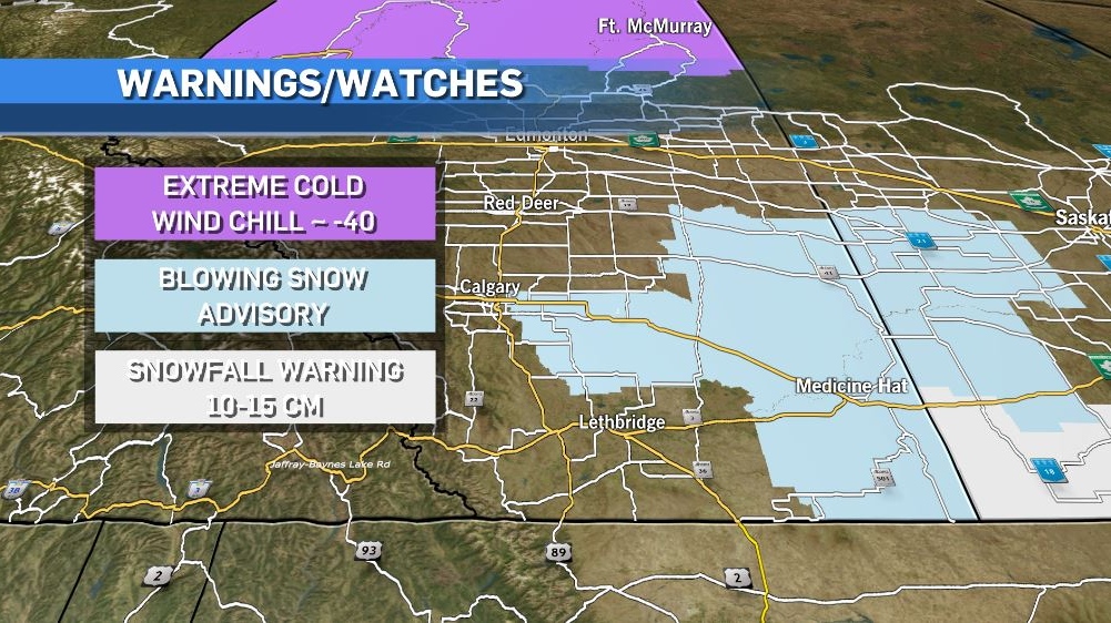
Gusty conditions also bringing cold overnight wind chills near -20 for central and southern Alberta.
Daytime temperatures Sunday not expected to warm up by much, which means wind chills through much of the day remain near -20.
Here’s the five day:
Sunday:
- Chance of morning flurries, mostly cloudy after that, winds gusty at times
- Daytime high: -10 C, wind chill -19
- Overnight: Mostly cloudy, -15 C, wind chill -21
Monday:
- Chance of light snow in the morning, sunny afternoon
- Daytime high: -7 C
- Overnight: Partly cloudy, -12 C
Tuesday:
- Partly cloudy
- Daytime high: 0 C
- Overnight: Mostly cloudy, -4 C
Wednesday:
- Clearing
- Daytime high: 2 C
- Overnight: Mostly cloudy, -6 C
Thursday:
- Partly cloudy
- Daytime high: -2 C
- Overnight: Chance of evening flurries, -12 C


CTVNews.ca Top Stories

LIVE NOW
LIVE NOW Budget 2024 prioritizes housing while taxing highest earners, deficit projected at $39.8B
In an effort to level the playing field for young people, in the 2024 federal budget, the government is targeting Canada's highest earners with new taxes in order to help offset billions in new spending to enhance the country's housing supply and social supports.
BUDGET 2024
BUDGET 2024 Feds cutting 5,000 public service jobs, looking to turn underused buildings into housing
Five thousand public service jobs will be cut over the next four years, while underused federal office buildings, Canada Post properties and the National Defence Medical Centre in Ottawa could be turned into new housing units, as the federal government looks to find billions of dollars in savings and boost the country's housing portfolio.
Some of the winners and losers in the 2024 federal budget
With a variety of fiscal and policy measures announced in the federal budget, winners include small businesses and fintech companies while losers include the tobacco industry and Canadian pension funds.
From housing initiatives to a disability benefit, how the federal budget impacts you
From plans to boost new housing stock, encourage small businesses, and increase taxes on Canada’s top-earners, CTVNews.ca has sifted through the 416-page budget to find out what will make the biggest difference to your pocketbook.
Liberals aim to hit the brakes on car theft with new criminal offences
The Liberals are proposing new charges for the use of violence while stealing a vehicle and for links to organized crime, as well as laundering money for the benefit of a criminal organization.
BUDGET 2024
BUDGET 2024 Ottawa police get $50 million to boost security around Parliamentary Precinct
The Ottawa Police Service will receive $50 million in new federal funding over the next five years to "enhance security" around the Parliamentary Precinct.
Liberals to dole out five years worth of carbon rebates to businesses
Small- and medium-sized business owners are set to receive a long-awaited refund from Ottawa, which was holding onto billions of dollars while it sorted out a way to deliver them their carbon pricing rebates.
Feds offer $5B in Indigenous loan guarantees, fall $420B short on infrastructure asks
The federal government is providing up to $5 billion in loan guarantees to help Indigenous communities invest in natural resource and energy products. But when it comes to a promise to close what advocates say is a sprawling Indigenous infrastructure gap, Ottawa is short more than $420 billion.
Police to announce arrests in Toronto Pearson airport gold heist
Police say that arrests have been made in connection with a $20-million gold heist at Toronto Pearson International Airport one year ago.
Shopping Trends
The Shopping Trends team is independent of the journalists at CTV News. We may earn a commission when you use our links to shop. Read about us.


Edmonton
-

Edmonton Zone health staff sound alarm over capacity for babies in intensive care
Staff caring for frail babies at hospitals in the Edmonton area are asking for help from the province.
-
$440K in stolen property recovered by RCMP during rural crime investigation
Three people have been charged after police recovered nearly half a million dollars worth of stolen property.
-
Pipeline involved in wildland fire, Yellowhead County says
A pipeline was involved in a wildfire in western Alberta on Tuesday, Yellowhead County says.
Lethbridge
-

Phillips calls for funding to be reinstated to Lethbridge Elder Abuse Response Network
Lethbridge West MLA Shannon Phillips is calling on the province to reinstate funding for the Lethbridge Elder Abuse Response Network.
-
Southern Alberta could be alive with the sound of rattlesnakes this weekend: expert
If you’re planning to head to the coulees this weekend to enjoy the nice weather, don’t forget to look down.
-
Lethbridge police team up with campaign to urge drivers to slow down
With the weather starting to feel like spring is really here, more kids will likely be outside enjoying the sunshine and warm temperatures, which organizers of the Slow Your Roll campaign say is a perfect time to re-launch the campaign.
Vancouver
-

B.C. court upholds conviction after man argues crowds, claustrophobia led to fatal Costco encounter
British Columbia's highest court has upheld a manslaughter conviction against a Vancouver man who shoved a senior outside a busy Costco store, rejecting his argument that the trial judge failed to consider how his claustrophobia and fear of crowds led to the fatal altercation.
-
Unifor withdraws Amazon union applications, citing 'suspiciously high' employee data
Unifor says it’s temporarily withdrawing its applications to represent workers at two Vancouver-area Amazon facilities, accusing the e-commerce giant of providing a “suspiciously high” employee count.
-
Developer subsidizing residents' transit use at Vancouver rental building
A Metro Vancouver developer is once again teaming up with TransLink to give users of one of its new buildings free access to transit and study the impact of the subsidy.
Vancouver Island
-

Relocated seal returns to Greater Victoria after 'astonishing' 204-kilometre trek
A moulting seal who was relocated after drawing daily crowds of onlookers in Greater Victoria has made a surprise return, after what officials described as an 'astonishing' six-day journey.
-
B.C. court upholds conviction after man argues crowds, claustrophobia led to fatal Costco encounter
British Columbia's highest court has upheld a manslaughter conviction against a Vancouver man who shoved a senior outside a busy Costco store, rejecting his argument that the trial judge failed to consider how his claustrophobia and fear of crowds led to the fatal altercation.
-
LIVE NOW
LIVE NOW Budget 2024 prioritizes housing while taxing highest earners, deficit projected at $39.8B
In an effort to level the playing field for young people, in the 2024 federal budget, the government is targeting Canada's highest earners with new taxes in order to help offset billions in new spending to enhance the country's housing supply and social supports.
Saskatoon
-

Sask. real estate company that lost investors' millions reaches settlement
The founders of a Saskatoon real estate investment company that left investors with millions of dollars in losses have reached a settlement with Saskatchewan’s financial and consumer watchdog.
-
Guilty pleas entered in beating of mentally ill man on Saskatchewan farm
Two men accused of beating and tying up a mentally ill man on a Saskatchewan farm have pleaded guilty to assault causing bodily harm.
-
Parts of Sask. could see up to 30 centimetres of snow, dangerous driving conditions: ECCC
Winter weather seemed to be in the rear view mirror for Saskatchewan the past couple weeks, but now Environment and Climate Change Canada (ECCC) is forecasting as much as 30 centimetres of snow for some parts of the province.
Regina
-

Parts of Sask. could see up to 30 centimetres of snow, dangerous driving conditions: ECCC
Winter weather seemed to be in the rear view mirror for Saskatchewan the past couple weeks, but now Environment and Climate Change Canada (ECCC) is forecasting as much as 30 centimetres of snow for some parts of the province.
-
HRF, Municipal Hail Insurance teaming up to bring latest technology to Regina General Hospital
Municipal Hail Insurance and the Hospitals of Regina Foundation (HRF) has teamed up to raise money for upgrades to the Mosaic Heart Centre at the Regina General Hospital (RGH).
-
'They want to be at the table': Sask. NDP leader calls for cooperation at SUMA
Saskatchewan NDP Leader Carla Beck highlighted concerns around mental health, addictions and infrastructure as she addressed the Saskatchewan Urban Municipalities Association (SUMA) conference.
Toronto
-

Police to announce arrests in Toronto Pearson airport gold heist
Police say that arrests have been made in connection with a $20-million gold heist at Toronto Pearson International Airport one year ago.
-
WATCH
WATCH Toronto woman has close encounter with coyote near Ontario Place
A Toronto woman is warning others to be on the lookout after a coyote approached her while she was sitting on a park bench near Ontario Place last weekend.
-
LIVE NOW
LIVE NOW Budget 2024 prioritizes housing while taxing highest earners, deficit projected at $39.8B
In an effort to level the playing field for young people, in the 2024 federal budget, the government is targeting Canada's highest earners with new taxes in order to help offset billions in new spending to enhance the country's housing supply and social supports.
Montreal
-

Quebec's refusal to deliver English presentation to parents raises questions about language law
Quebec's education ministry says it is working on clarifying directives on when officials can communicate with the public in a language other than French.
-
Teenagers' screen time has dropped post-pandemic: Montreal Public Health
Teenagers are showing post-pandemic improvements when it comes to screen time, according to a new study published Tuesday by Montreal Public Health.
-
Quebec court approves class action alleging opioid makers misled users about risks
A Quebec Superior Court judge has authorized a class-action lawsuit against 16 pharmaceutical companies that are alleged to have misled consumers about the efficacy and dangers of opioid medications.
Atlantic
-

500 Newfoundlanders wound up on the same cruise and it turned into a rocking kitchen party
A Celebrity Apex cruise to the Caribbean this month turned into a rocking Newfoundland kitchen party when hundreds of people from Canada's easternmost province happened to be booked on the same ship.
-
4 people charged in connection with N.S. man’s 2022 death
The Nova Scotia RCMP says four people have been charged following a man’s homicide two years ago.
-
Halifax Transit bus involved in three-vehicle crash in city’s downtown
A portion of Barrington Street has reopened after a three-vehicle crash Tuesday morning.
Winnipeg
-

Teen hockey players arrested for sexual assault following hazing incident: Manitoba RCMP
Three teenagers were arrested in connection with a pair of alleged hazing incidents on a Manitoba hockey team, police say.
-
LIVE NOW
LIVE NOW Budget 2024 prioritizes housing while taxing highest earners, deficit projected at $39.8B
In an effort to level the playing field for young people, in the 2024 federal budget, the government is targeting Canada's highest earners with new taxes in order to help offset billions in new spending to enhance the country's housing supply and social supports.
-
'It's troubling': Winnipeg sports memorabilia store target of three break-ins
One Winnipeg sports memorabilia shop has been the target of multiple break-ins and is now looking to recover some stolen property.
Ottawa
-
 BUDGET 2024
BUDGET 2024 Feds cutting 5,000 public service jobs, looking to turn underused buildings into housing
Five thousand public service jobs will be cut over the next four years, while underused federal office buildings, Canada Post properties and the National Defence Medical Centre in Ottawa could be turned into new housing units, as the federal government looks to find billions of dollars in savings and boost the country's housing portfolio.
-
LIVE NOW
LIVE NOW Budget 2024 prioritizes housing while taxing highest earners, deficit projected at $39.8B
In an effort to level the playing field for young people, in the 2024 federal budget, the government is targeting Canada's highest earners with new taxes in order to help offset billions in new spending to enhance the country's housing supply and social supports.
-
BUDGET 2024
BUDGET 2024 New funding for NAC, no cash for OC Transpo in federal budget
CTVNewsOttawa.ca looks at four things in the federal budget that will have an impact on the city of Ottawa.
Northern Ontario
-

Northern Ont. driver missing after vehicle pulled into creek
Rescue crews are searching for a man reported missing on the weekend after the vehicle he was driving was pulled into a creek near the Quebec border in northern Ontario.
-
YMCA in the Sault ceasing operations next month
The YMCA of Sault Ste. Marie is selling its building and ceasing operations in May.
-
The zipper is back: Early start to road construction season in Sudbury
City officials in Sudbury say construction season started early this year thanks to the warm weather this spring.
Barrie
-
 BREAKING
BREAKING Glenn Howard, iconic Canadian curler, announces retirement
One of the nation's most beloved and decorated curlers, Glenn Howard, officially announced his retirement on Tuesday.
-
Casino Rama adds new shows to its 2024 performance lineup
Two new shows are coming to Casino Rama's Entertainment Centre for fans of country music and 80s rock.
-
Apartment fire linked to battery-operated vacuum cleaner
Fire officials say a lithium-ion battery inside a vacuum cleaner sparked a fire at an apartment complex Sunday afternoon in Gravenhurst.
Kitchener
-

Grand River Rocks time in new home is limited
Grand River Rocks will have limited time in their new home on Victoria Street North, after Kitchener City Council officially approved the rezoning of the property to allow for a condo development.
-
Cost of policing St. Patrick’s Day in Waterloo estimated at $318,000 this year
Waterloo Regional Police Services has released the estimated total cost for the St. Patrick’s Day weekend in the city of Waterloo.
-
Brantford police looking for pickpocket suspects
Brantford police are investigating a series of personal thefts and are seeking information from the public to identify the people responsible.
London
-
 BREAKING
BREAKING Fatal crash on Highway 401 claims 1 life, eastbound lanes closed
A two-vehicle crash between a pickup truck and a transport truck on Highway 401 south of London, Ont. has resulted in one fatality Tuesday afternoon, with police warning motorists to expect delays in the area.
-
'It’s pretty messed up': Vaping and vandalism continue to impact high school students and staff across the region
It’s an issue affecting local high schools across the Thames Valley District School Board (TVDSB) and the London District Catholic School Board (LDCSB).
-
'Not worth it': London, Ont. driver charged after travelling nearly 200 km/h on Highway 401
A driver from London will have to find alternative transportation after an OPP officer clocked them travelling nearly 200 km/h on Highway 401 over the weekend.
Windsor
-

Landlord group to appeal court decision over residential rental bylaw
A group of landlords contesting the city’s new residential rental licensing bylaw is appealing a recent court decision.
-
LIVE NOW
LIVE NOW Budget 2024 prioritizes housing while taxing highest earners, deficit projected at $39.8B
In an effort to level the playing field for young people, in the 2024 federal budget, the government is targeting Canada's highest earners with new taxes in order to help offset billions in new spending to enhance the country's housing supply and social supports.
-
'He’s done great things': incarcerated Windsorite works to make prison more culturally sensitive for fellow inmates
The ‘faint hope’ hearing of Ali Al-Shammari, 38, continued Tuesday in Superior court.


