Calgary hits the 20s on Friday then drops into scattered flurries for a few days
UPDATE: WELP, g'bye, heat. We had a good run. If you're reading this Friday afternoon and raising an eyebrow, I get it! I do! But the day's decline has indeed already begun. Gusts are fierce out of the west in the 2 o'clock hour, peaking in the mid-50 km/h range, with our airport registering 19.3 C. At noon, we were at 21.1 C.
I would love to tell you it stays warm a little longer. I'd love to tell you that - but I cannot. Our slow descent accelerates out of the double-digits this evening, and we don't pick that back up for a while, still.
Tomorrow's forecast remains the most troublesome for prediction; on one hand, we have showers lined up; on the other, dry as a bone. I'm upgrading it to a chance of scattered showers.
Our temperatures have "improved" into next week, as well. That's not to say we'll rise above freezing... but hey, any improvement helps!
The low developing in B.C. will dredge into northern Alberta later today.
Far into the north, there’s potential for freezing rain among rain and snow.
Closer to home, this system affects us by amplifying wind gusts. Yesterday, a few projections among the foothills placed gusts in the 80s and possibly the low 90 km/h range. Locally, gusts could top out at 65 km/h.
Coupled with the ridge of high pressure and overnight lows that blasted expectations (model projections from 3-5 C, current low as of 4 am 7.6 C), it’s going to be a toasty one. On-air yesterday, I said I wouldn’t be surprised if today rose above the expected 20 C. The feet are planted on that hypothesis. The updated high for today reflects that. The record high for today was set in 1977 at 25 C – it’s unlikely we put a dent there.
With the dewpoint temperature and our relative humidity still crashing low, along with an updated wind gust potential remaining at 40-50 km/h tomorrow from the west, dry weather has slammed potential for showers or flurries Saturday, though it will remain a milder day; Sunday, the westerlies swap to northern wind, and we still run a shot at flurries there.
There is a single forecast model (GFS) with a heavy prediction of showers and snow over southern Alberta tomorrow. I’m going to dig into this for the afternoon update when I’m at the office and can do some additional work with our in-house forecast models – stay tuned, and keep those expectations low.
Tracking beyond the weekend, it remains to be seen if any major pockets of moisture will hit the ground. Scattered flurries are the best hope we have from Sunday straight out to next Thursday, as some forecasts have it – it’s not reliable to try tracking precipitation beyond that point, as lots can change. The temperature trend is only marginally more feasible to follow, with seasonal temperatures not shaking out for at least another ten days.
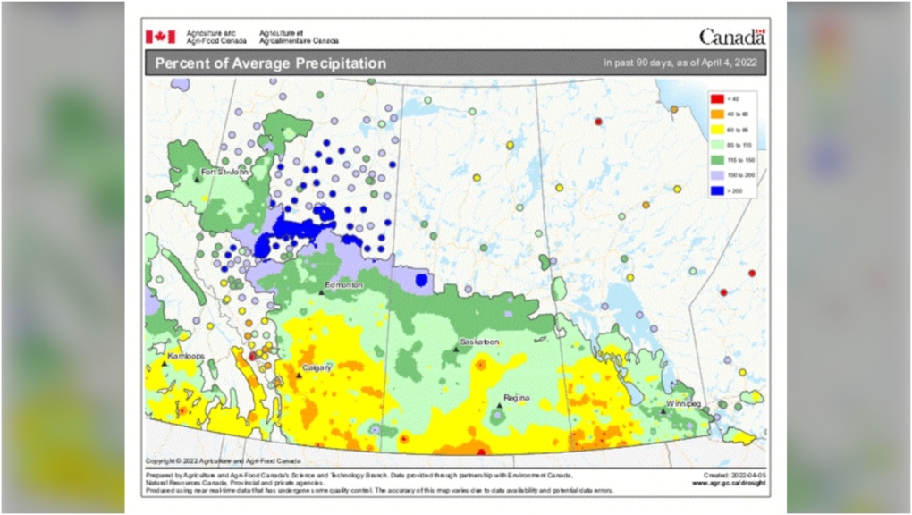
I’ve spoken at length about the desperate need for those rain-showers; the map below is our percent of average precipitation over the last ~90 days, back-tracked to the 4th of April. In isolated spots, it’s only 40-60% of normal. That’s dry earth. No additional fire pit forecast information is available beyond yesterday’s, though some advisories remain in place, including a fire ban for the city of Lethbridge.
More information on our precipitation, by percent of average or numeric departure from normal at this link to Agriculture and Agri-Food Canada. Percent of average precipitation. Your five-day forecast:
Tonight
- Evening: some cloud, low 3 C
Saturday
- Partly cloudy, windy, chance of scattered precipitation
- Daytime high: 9 C
- Evening: flurries, low -1 C
Sunday
- Partly cloudy
- Daytime high: 2 C
- Evening: scattered flurries, low -7 C
Monday
- Partly cloudy
- Daytime high: -3 C
- Evening: scattered flurries, low -10 C
Tuesday
- Mainly cloudy, scattered flurries
- Daytime high: -5 C
- Evening: scattered flurries, low -10 C
Wednesday
- Mainly cloudy, scattered flurries
- Daytime high: 0 C
- Evening: scattered flurries, low -8 C
Today’s pic is from Crystal near McKenzie Lake at sunset the other day:
 Sunrise in Calgary's McKenzie Lake.We love to see your pictures of weather, wildlife, and pets – submit your photos here, email me here, or tweet them over.
CTVNews.ca Top Stories

B.C. carjacking suspect sped across U.S. border before arrest, police say
Authorities have arrested a suspect who allegedly carjacked a pickup truck in B.C.'s Lower Mainland then sped across the U.S. border, triggering a massive police response.
Alberta premier says federal border plan coming Monday
The much-anticipated federal plan to address issues at the Canada-U.S. border will be unveiled on Monday according to Alberta Premier Danielle Smith.
Ottawa has sold its stake in Air Canada: sources
Two senior federal government sources have confirmed to CTV News that the federal government has sold its stake in Air Canada. During the COVID-19 pandemic in 2021, the government purchased a six per cent stake in the airline for $500 million as part of a bailout package.
Premiers disagree on whether Canada should cut off energy supply to U.S. if Trump moves ahead with tariffs
Some of Canada's premiers appeared to disagree with Ontario Premier Doug Ford on his approach to retaliatory measures, less than a day after he threatened to cut off the province's energy supply to the U.S. if president-elect Donald Trump follows through on his threat of punishing tariffs.
'Very concerned': Crews search B.C. ski resort for missing man
Police and rescue crews are searching for a man who was last seen boarding a ski lift at B.C.'s Sun Peaks Resort Tuesday.
Man who set fires inside Calgary's municipal building lost testicle during arrest: ASIRT
Two Calgary police officers have been cleared of any wrongdoing in an incident that saw a suspect lose a testicle after being shot with an anti-riot weapon.
Blizzard warning shuts down large parts of midwestern Ontario
It was a day to stay home, if you could, across much of midwestern Ontario due to weather.
Travis Vader, killer of Lyle and Marie McCann, denied day parole
The man who killed an Alberta couple in 2010 has been denied day parole.
She took a DNA test for fun. Police used it to charge her grandmother with murder in a cold case
According to court documents, detectives reopened the cold case in 2017 and then worked with a forensics company to extract DNA from Baby Garnet's partial femur, before sending the results to Identifinders International.


