More frost advisories possible in central Alberta tonight
AFTERNOON UPDATE: If you read the morning outlook daily, you'll go through this paragraph and think I'm phoning it in. At least, that's how it feels for me, too.
We have an added touch of cloud right now but otherwise our forecast for the day is rock-steady. Central Alberta may indeed crest close to the freezing mark; a few spots dropped into the frost margins this morning, including Nordegg, Priddis, Banff, and Waterton. Calgary had a site report in at 1.4 C for the low marker.
Watch for those frost advisories within the next couple of hours — likely by 4 p.m.
Temperature-wise, the next few days are holding firm near 20 C; there's a longer-range chance of showers, but as our forecast models have already let us down more than once this spring, I'll reserve judgement on that.
MORNING OUTLOOK: Frost advisories in our province ended early Tuesday morning and I don't expect them to return to southern Alberta, though central Alberta may see a couple repopulate once again.
We set in to high pressure and this weak blocking pattern for the next few days. Yesterday, the descriptor was banal. Today, I'm going with benign.
The blocking pattern in question is the result of a pair of flanking lows aloft; neither will concede ground for a while. It's known as an Omega Block, where a high centres between two low pressure regions in the tips of the Omega symbol:
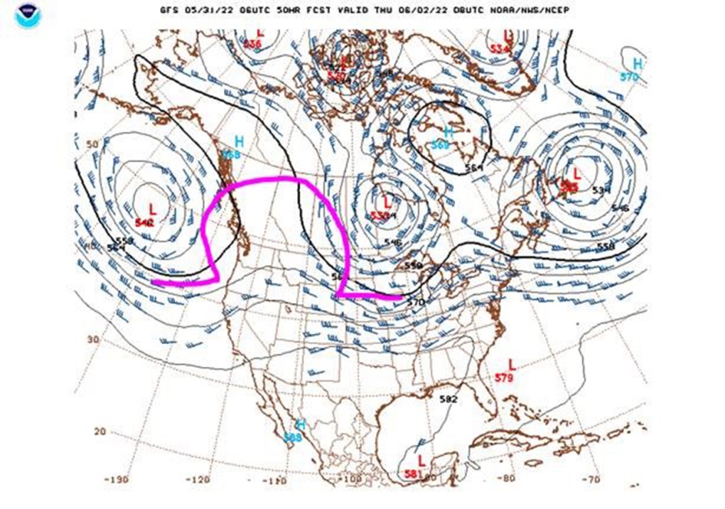
This version is a little rough around the edges when compared to a more classic setup, but it's close. That's the Thursday outlook in the image above. It started yesterday evening, in fairness; the northern wind yesterday was the fault of the eastern low, piling over Manitoba, which has that strong northerly influence on its west flank and cleared our cloud away. The second low is out over the Pacific. I popped this projection further ahead and confirmed that we'll still have this pair of lows present come the weekend, though the high pressure down the middle will fade. This won't change much; we'll just get a little extra cloud on top of being sandwiched in these lows.
To repeat: Extra cloud; not rain. The growing season conditions will worsen before they improve.
YOUR FIVE-DAY CALGARY FORECAST:
Tuesday
- Evening: mainly clear, low 6 C
Wednesday
- Partly cloudy
- Daytime high: 18 C
- Evening: some cloud, low 7 C
Thursday
- Sunny
- Daytime high: 21 C
- Evening: clear, low 8 C
Friday
- Sunny
- Daytime high: 22 C
- Evening: building cloud, low 11 C
Saturday
- Partly cloudy
- Daytime high: 22 C
- Evening: partly cloudy, low 10 C
Sunday
- Mainly cloudy
- Daytime high: 19 C
- Evening: partly cloudy, low 11 C
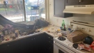
Today's pic is from Rich, who appreciated the cloud formations around midday:

Submit your weather photos here to see them featured in our article, and perhaps even as the pic of the day during our News at Six!


CTVNews.ca Top Stories

BREAKING
BREAKING Israel attacks Iran, Reuters sources say; drones reported over Isfahan
Israel has attacked Iran, three people familiar with the matter told Reuters, as Iranian state media reported early on Friday that its forces had destroyed drones, days after Iran launched a retaliatory drone strike on Israel.
American millionaire Jonathan Lehrer denied bail after being charged with killing Canadian couple
American millionaire Jonathan Lehrer, one of two men charged in the killings of a Canadian couple in Dominica, has been denied bail.
Nearly half of China's major cities are sinking, researchers say
Nearly half of China's major cities are suffering 'moderate to severe' levels of subsidence, putting millions at risk of flooding especially as sea levels rise.
Prince Harry formally confirms he is now a U.S. resident
Prince Harry, the son of King Charles III and fifth in line to the British throne, has formally confirmed he is now a U.S. resident.
Judge says 'no evidence fully supports' murder case against Umar Zameer as jury starts deliberations
The judge presiding over the trial of a man accused of fatally running over a Toronto police officer is telling jurors the possible verdicts they may reach based on the evidence in the case.
Health Canada to change sperm donor screening rules for men who have sex with men
Health Canada will change its longstanding policy restricting gay and bisexual men from donating to sperm banks in Canada, CTV News has learned. The federal health agency has adopted a revised directive removing the ban on gay, bisexual and other men who have sex with men, effective May 8.
Colin Jost names one celebrity who is great at hosting 'Saturday Night Live'
Colin Jost, who co-anchors Saturday Night Live's 'Weekend Update,' revealed who he thinks is one of the best hosts on the show.
Sports columnist apologizes for 'oafish' comments directed at Caitlin Clark. The controversy isn't over
A male columnist has apologized for a cringeworthy moment during former University of Iowa superstar and college basketball's highest scorer Caitlin Clark's first news conference as an Indiana Fever player.
'Shopaholic' author Sophie Kinsella reveals brain cancer diagnosis
Sophie Kinsella, the best-selling author behind the 'Shopaholic' book series, has revealed that she is receiving treatment for brain cancer.
Shopping Trends
The Shopping Trends team is independent of the journalists at CTV News. We may earn a commission when you use our links to shop. Read about us.


Edmonton
-

Alberta introducing legislation to stabilize electricity rates, educate customers about RRO
Alberta is introducing new legislation aimed at preventing spikes in electricity prices.
-
'It hurts': Edmonton man frustrated after false Roll up the Rim win
An Edmonton man is feeling let down after Tim Hortons mistakenly told him he'd won a boat.
-
Worker dies after fall at north Edmonton construction site
Occupational Health and Safety (OHS) is investigating after a worker fell to their death earlier this week.
Lethbridge
-

Deterrent sentence possible, expert says, after trio convicted in connection to Coutts border blockade
Three men who helped lead and co-ordinate the 2022 border blockade at Coutts, Alta., have been found guilty of public mischief.
-
Central Alberta man arrested in connection with grandparent scam
Lethbridge police have arrested a Vermilion, Alta., man in connection with a 'grandparent scam' that took aim at a local senior.
-
Woman, 61, killed in crash north of Coaldale, Alta.: RCMP
An Alberta woman was killed in a multi-vehicle crash on a highway north of Coaldale, Alta., on Wednesday morning.
Vancouver
-

B.C. premier defends drug decriminalization as controversy grows, feds scrutinize program
The premier of British Columbia is continuing to defend the three-year pilot program underway in his province that’s decriminalized personal possession of hard drugs, even as the federal government sends its minister responsible to discuss growing concerns and controversies.
-
UBC football star turning heads in lead up to NFL draft
At 6'8" and 350 pounds, there is nothing typical about UBC offensive lineman Giovanni Manu, who was born in Tonga and went to high school in Pitt Meadows.
-
Delta police seek witnesses to rollover crash
Police in Delta are appealing for witnesses and information after a mid-afternoon rollover crash into the front yard of a home last week.
Vancouver Island
-
B.C. premier defends drug decriminalization as controversy grows, feds scrutinize program
The premier of British Columbia is continuing to defend the three-year pilot program underway in his province that’s decriminalized personal possession of hard drugs, even as the federal government sends its minister responsible to discuss growing concerns and controversies.
-
$60K worth of Indigenous art stolen in Saanich, B.C., police say
A large collection of First Nations art worth more than $60,000 was stolen in Saanich earlier this month, police announced Thursday.
-
B.C.'s short-term rental regulations include $10K daily penalties for Airbnb, other platforms
Short-term rental platforms that violate B.C.'s pending regulations can face administrative penalties of up to $10,000 per day, officials announced Thursday.
Saskatoon
-

Final offer or tentative agreement? Teachers, province differ on what latest deal means
Saskatchewan Teachers' Federation (STF) President Samantha Becotte says two days of "difficult" negotiations has led to a "final offer" with slight improvements to salary and the inclusion of a line in the collective agreement – promising to address classroom complexity issues.
-
Saskatoon police committing three officers to curb crime in Pleasant Hill
The Saskatoon Police Service (SPS) is dedicating three officers to a specialized unit to help curb crime in the Pleasant Hill neighbourhood.
-
Sask. village, contractor fined $42,000 for illegal dumping
A Saskatchewan village and a contractor it hired are facing significant fines after conservation officers discovered they dumped demolition waste at an illegal landfill.
Regina
-

'Poor choice of words': Education Minister apologizes for remarks made to Sask. mother
On Thursday, Education Minister Jeremy Cockrill apologized for remarks he made to a mother who had advocated for better classroom supports earlier this week.
-
Sask. dental providers and seniors raise concerns over federal dental care plan
With the Canadian Dental Care Plan (CDCP) set to roll out on May 1, many dental care providers have concerns and unanswered questions about the plan.
-
'Bad taste in your mouth': Regina man mistakenly told he won $50K boat through Roll up the Rim
Chris Ross was pleasantly surprised when Tim Hortons sent him an email summarizing his "Roll up the Rim" winnings for the season. The email claimed Ross had won a boat valued at over $50,000 – but it was a mistake.
Toronto
-

Grandparent scam suspects had ties to Italian organized crime, police allege
A group of suspects that allegedly defrauded seniors across Ontario and other parts of Canada using a so-called emergency grandparent scam appear to have ties to 'Italian traditional organized crime,' according to an investigator involved in the OPP-led probe.
-
'He left a mark in this world': Thorncliffe Park teen who drowned in Lake Ontario remembered
He was a loving son and brother, a loyal and kind friend, and a dedicated volunteer in Toronto’s east end, say those who knew and loved Mohammad Khasim.
-
Cat found on Toronto Pearson airport runway 3 days after going missing
Kevin the cat has been reunited with his family after enduring a harrowing three-day ordeal while lost at Toronto Pearson International Airport earlier this week.
Montreal
-

Quebec judge suspends parts of Bill 96 that apply to English school boards
The English Montreal School Board (EMSB) is celebrating what it calls a 'significant win' in court after a judge stayed parts of Quebec's language laws that apply to English school boards across the province.
-
Quebec to follow Ottawa's lead on capital gains taxation
Quebec intends to follow Ottawa's lead and increase its capital gains tax rate. The Quebec government announced late on Thursday that its tax system will be adjusted to bring it into line with five measures proposed in the latest federal budget.
-
American millionaire Jonathan Lehrer denied bail after being charged with killing Canadian couple
American millionaire Jonathan Lehrer, one of two men charged in the killings of a Canadian couple in Dominica, has been denied bail.
Atlantic
-

Nova Scotia premier says agreement reached with teachers union, strike averted
Nova Scotia Premier Tim Houston says an agreement in principle has been reached on a new contract for public school teachers.
-
N.S. justice minister apologizes for domestic violence comments
Nova Scotia's opposition parties are calling for the justice minister to resign after he said domestic violence is not an "epidemic."
-
Neighbours left frustrated after years of cows roaming free in N.B. area
Some residents in rural New Brunswick are frustrated with cows that roam into their properties.
Winnipeg
-

'It could be catastrophic': Woman says natural supplement contained hidden pain killer drug
A Manitoba woman thought she found a miracle natural supplement, but said a hidden ingredient wreaked havoc on her health.
-
'This is an eyesore': City charting plan to clean giant debris left for two years on Sherbrook Street
The City of Winnipeg is finally moving ahead with a plan to clear away a large pile of debris on a private lot.
-
'This program has saved lives': New report highlights success of Mobile Overdose Prevention Site during first year of operation
The Mobile Overdose Prevention Site operated by Sunshine House has been in operation since late 2022, and now a report is being released sharing the results of its first year.
Ottawa
-
 NEW THIS MORNING
NEW THIS MORNING What's happening in Ottawa this weekend: April 19-21
CTVNewsOttawa.ca looks at things to do in Ottawa this weekend.
-
1 dead following wrong-way crash on Hwy. 417 in Ottawa's east end
The driver killed in a head-on crash on Hwy. 417 in Ottawa's east end was driving eastbound in the westbound lanes when the vehicle collided with a second vehicle, according to Ontario Provincial Police.
-
Barrhaven's mass killing suspect appears in court Thursday, here's what's new
The suspect accused of murdering six people at a home in Barrhaven made another brief court appearance Thursday afternoon.
Northern Ontario
-

Private Northern Ont. college accused of taking tuition, but not offering courses
A private career college in North Bay is under intense scrutiny from students for taking tuition but not offering courses, and from former teachers who say they haven't been paid.
-
State of emergency still in effect in northern communities
Some communities in northeastern Ontario remain under a state of emergency due to last Friday’s rain.
-
Parry Sound man among those falsely told by Tim Hortons that they won a boat
Tim Hortons says human error is to blame for some customers thinking they had won a boat in a recent digital roll up to win contest.
Barrie
-

Driver suffers life-threatening injuries in Hwy 12 collision
One person suffered life-threatening injuries after a collision with a commercial vehicle on Highway 12 at Forest Avenue in Orillia early Thursday afternoon.
-
Surviving the economic vortex: How restaurants can weather inflation's storm
As inflation tightens its grip on the economy, many people are feeling the pinch, from housing to transportation to retail and services, including restaurants.
-
Discreditable conduct Police Services Act hearing for Barrie police veteran
The hearing for a Barrie police officer charged with discreditable conduct following an OPP investigation continued Thursday morning over teleconference.
Kitchener
-
Landlords reporting increase in tenants refusing to pay rent or leave
A property management company in Fergus is still cleaning up after they say a tenant trashed one of their units and refused to pay rent -- and they say it's not the only similar case they've dealt with recently.
-
Gas price hike blamed on change in seasons, motorists 'shocked'
Gas prices across Ontario have spiked to levels not seen in nearly two years as the switch from winter fuel to a more expensive summer blend pushes the price at the pumps.
-
What are these things doing in Waterloo Park?
Don’t be alarmed if you see some strange new creatures in Waterloo Park.
London
-

'Mistakes happen': Health minister says patients have recourse if charged inappropriately
The provincial government is advising there is recourse for those who believe they've been wrongfully billed for healthcare services.
-
Witness alleges years of severe abuse at the hands of parents
A jury heard some horrific evidence Thursday at the trial of a London, Ont. couple charged with physically and sexually abusing their children.
-
Mourning loss of affordable housing in London
Members of London Acorn chanted slogans and called for urgent action from all levels of government to prevent the loss of affordable housing units.
Windsor
-

'I wasn’t assaulting him but I also was not helping him': convicted Windsorite provides jury with first-person account of murder
Ali Al-Shammari is 20 years into a life sentence for the first-degree murder of Thualfikar Alantiyya, 41, killed on November 19, 2004.
-
'I’m upset': Several Windsorites frustrated after Tim Hortons prize email sent in error
Some Tim Hortons customers in Windsor are feeling dismayed and considering legal action after being told by the company that an email stating they won a boat worth nearly $60,000 was sent in error.
-
'This is a gun-free event': Detroit police chief unveils plans for NFL Draft weekend
Officials in Detroit say prepartions are well in hand as hundreds of thousands of people are expected to come to the Motor City from April 25 to 27 for the NFL Draft.


