Freezing fog creates near-zero visibility and slick roads early Thursday
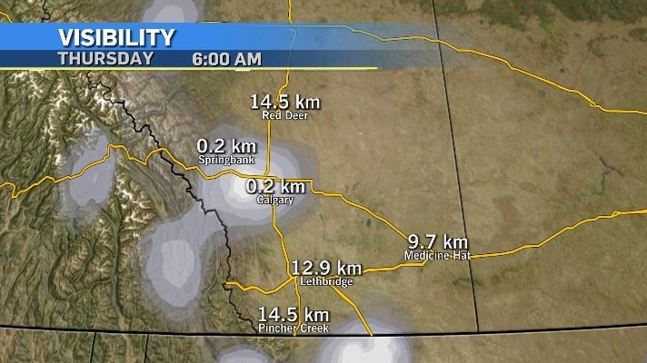
Drivers in Calgary woke up to a thick layer of freezing fog.
Freezing fog can occur when saturated air (fog) forms in temperatures below freezing and, similar to freezing drizzle, deposits a layer of rime or glaze (ice) on surfaces that are also below freezing.
This scenario can be especially dangerous for drivers as it produces icy surfaces in conditions of low visibility.

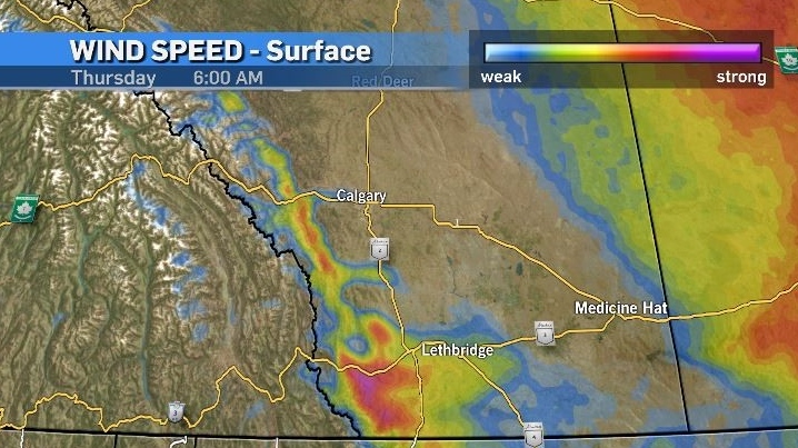
The winds in and around Calgary were minimal early Thursday and, without any mixing of the air closer to the surface, the freezing fog is likely to linger throughout the morning commute.

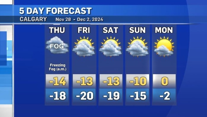
Later in the day Thursday, temperatures will remain cooler across the region with a persistent weather pattern continuing to funnel Arctic air from the northwest to southeast corners of the western Prairies.
Relief is expected at the end of the weekend with a shift in this weather pattern.
Strong winds will likely be the first indication of this change as westerly flow sets up across the Rockies.
Monday will be the warmest day (and the first day above freezing) in over two weeks.
The daytime high on Monday is forecast to reach at least 0 C, or 10 degrees warmer than Sunday’s high.

CTVNews.ca Top Stories

Trudeau talks border, trade in surprise dinner with Trump at Mar-a-Lago
Prime Minister Justin Trudeau discussed border security and trade during a surprise dinner with U.S.-president elect Donald Trump at Mar-a-Lago in West Palm Beach, Fla. on Friday evening, according to senior government sources.
W5 Investigates 'I never took part in beheadings': Canadian ISIS sniper has warning about future of terror group
An admitted Canadian ISIS sniper held in one of northeast Syria’s highest-security prisons has issued a stark warning about the potential resurgence of the terror group.
Man wanted after allegedly hitting vehicle repeatedly with hatchet near Toronto courthouse
Police are searching for a man who allegedly hit a car with a hatchet multiple times while yelling at the driver near a courthouse in downtown Toronto earlier this week.
Trump and Republicans in Congress eye an ambitious 100-day agenda, starting with tax cuts
Republicans are planning an ambitious 100-day agenda with U.S. president-elect Donald Trump in the White House and GOP lawmakers in a congressional majority to accomplish their policy goals.
Are scented candles bad for you? What the science says
Concerns about the safety of candles are rooted in the chemical reactions that occur when you burn them, as well as in the artificial fragrances and colorants that contribute to the various scents you may love.
Montreal researchers make breakthrough discovery in fighting HIV
Researchers in Montreal have made a breakthrough discovery in HIV research by finding a way to expel the virus from its hiding places and destroy it.
'Very alarming:' Online scams spike during the holidays
Shoppers are out looking for the best deals on gifts for their loved ones. However, the RCMP and the Better Business Bureau are warning people that the deals they’re seeing online might be too good to be true.
Man who died trying to help stranded motorist identified as Khalid Farooq, father of 5
The man who lost his life trying to help a stranded motorist Wednesday has been identified as Khalid Farooq.
Postal workers union files unfair labour practice complaint over Canada Post layoffs
The union representing Canada Post workers has filed an unfair labour practice complaint with the Canada Industrial Relations Board over the layoffs of striking employees.


