The Thursday afternoon/evening update: showers? Not nearly as likely
UPDATE: First, thundershower potential has all but quit for your Thursday evening. Rainshowers are a distant possibility.
The Friday forecast still involves that "chance of" a thundershower, with a better risk of rain. Central Alberta is the primary recipient again. Saturday, there's now an incredibly small chance of rain, and that's baked into another wave of showers for, you guessed it, Central Alberta.
Sunday and Monday are the warm spots, but as our forecast tends to do, we're right back into shower potential Tuesday, and it may carry on out to Friday, but since we're talking about eight days from now, we may have to press pause on promising precipitation locally. For now.
Thursday’s forecast for Calgary has undergone some shifts over the last few days — originally we planned on staying high and dry and then a chance of thundershowers advanced on us.
Now, it’s downgraded to a chance for weak showers this evening, as the marginal mid-level instability that governed storm potential earlier in the week has moved north. The front half of the forecast involves a good deal of sunshine, which has been the primary thread running through the week.
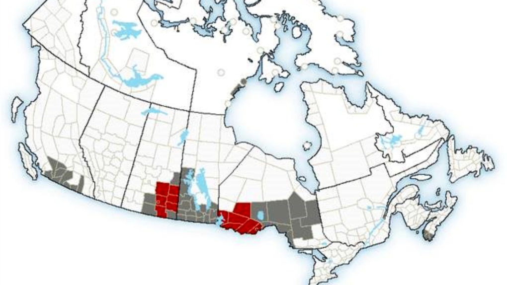
With the large storm barrelling toward the eastern prairies, Calgary has opened a chance for thundershowers Friday evening, as instability will emerge in the storm’s wake. The chance of a storm is minimal; the chance of showers is far better.
Special weather statements (in grey) for this storm call for 20-40 millimetres of rain and in the warning zones, 30-50 mm is expected.
Portions of B.C. are also facing weather statements, as a helping of snow is expected in higher elevations there. Something to consider if you have travel plans.
Beyond, the forecast for Calgary cycles into a warming pattern. Friday offers a slight dip, but the weekend is more than prepared to make up for it. We’ll fall under a ridge of high pressure Sunday, with the outlook still peeking at showers in the midweek forecast ahead of the May long weekend.
Your five-day forecast:
Thursday
- Some cloud, low 1 C
Friday
- Mainly cloudy, windy (50 km/h gusts), chance of showers, small thundershower risk
- Daytime high: 15 C
- Evening: some cloud, low 4 C
Saturday
- Mainly cloudy
- Daytime high: 16 C
- Evening: mainly clear, low 1 C
Sunday
- Mainly sunny
- Daytime high: 20 C
- Evening: some cloud, low 7 C
Monday
- Partly cloudy, P.M. shower risk
- Daytime high: 21 C
- Evening: mainly cloudy, scattered showers, low 8 C
Tuesday
- Cloudy, showers
- Daytime high: 15 C
- Evening: mainly cloudy, low 3 C
Today’s pic is from Niel, who sent it in sideways with the comment "Glenmore Reservoir – upside right or upside down?" Cheeky, sir.

Submit your weather photos here to see them featured in our article, and perhaps even as the pic of the day during our news at six.


CTVNews.ca Top Stories

Quebec nurse had to clean up after husband's death in Montreal hospital
On a night she should have been mourning, a nurse from Quebec's Laurentians region says she was forced to clean up her husband after he died at a hospital in Montreal.
Northern Ont. lawyer who abandoned clients in child protection cases disbarred
A North Bay, Ont., lawyer who abandoned 15 clients – many of them child protection cases – has lost his licence to practise law.
Bank of Canada officials split on when to start cutting interest rates
Members of the Bank of Canada's governing council were split on how long the central bank should wait before it starts cutting interest rates when they met earlier this month.
Maple Leafs fall to Bruins in Game 3, trail series 2-1
Brad Marchand scored twice, including the winner in the third period, and added an assist as the Boston Bruins downed the Toronto Maple Leafs 4-2 to take a 2-1 lead in their first-round playoff series Wednesday
Cuban government apologizes to Montreal-area family after delivering wrong body
Cuba's foreign affairs minister has apologized to a Montreal-area family after they were sent the wrong body following the death of a loved one.
'It was instant karma': Viral video captures failed theft attempt in Nanaimo, B.C.
Mounties in Nanaimo, B.C., say two late-night revellers are lucky their allegedly drunken antics weren't reported to police after security cameras captured the men trying to steal a heavy sign from a downtown business.
What is changing about Canada's capital gains tax and how does it impact me?
The federal government's proposed change to capital gains taxation is expected to increase taxes on investments and mainly affect wealthy Canadians and businesses. Here's what you need to know about the move.
New Indigenous loan guarantee program a 'really big deal,' Freeland says at Toronto conference
Canada's Deputy Prime Minister Chrystia Freeland was among the 1,700 delegates attending the two-day First Nations Major Projects Coalition (FNMPC) conference that concluded Tuesday in Toronto.
'Life was not fair to him': Daughter of N.B. man exonerated of murder remembers him as a kind soul
The daughter of a New Brunswick man recently exonerated from murder, is remembering her father as somebody who, despite a wrongful conviction, never became bitter or angry.
Shopping Trends
The Shopping Trends team is independent of the journalists at CTV News. We may earn a commission when you use our links to shop. Read about us.


Edmonton
-

Nurse practitioners to make 80% as much as family doctors for publicly-funded primary care
The Alberta government says it will pay nurse practitioners 80 per cent of what family doctors are paid – if they want to practice comprehensive primary care.
-
MacTavish on Oilers-Kings Game 2: 'It's going to be a completely different game'
Former Oilers player, coach and general manager Craig MacTavish talks to CTV News Edmonton's Matt Woodman about playoff hockey and Game 2 between Edmonton and Los Angeles.
-
Measles case in Edmonton prompts exposure warning
Alberta Health Services issued a measles alert in Edmonton Wednesday after confirming a case.
Lethbridge
-
Fire risk for southern Alberta high: Natural Resources Canada
It’s not even May 1 and the fire risk for southern Alberta is already alarming.
-
Lethbridge’s Whoop-Up Days accepting applications to be in 2024 parade
Whoop-Up Days is still four months away, but applications to be in this year’s parade are now open.
-
Lethbridge added 28 physicians over the past year, AHS continues search for more
Lethbridge has added 28 physicians over the past year, according to a quarterly report published by the College of Physicians and Surgeons of Alberta.
Vancouver
-

'Enjoy the run' but don’t expect major economic boost from Canucks playoffs: expert
A Canadian sports economist is encouraging Canucks fans to enjoy the team’s playoff run, but cautioning against having big expectations around economic spinoffs.
-
'A bad welcome': B.C. stabbing victim is new to Canada, wife says
The man who was stabbed by a stranger on the White Rock Pier last weekend is new to Canada, according to his wife.
-
'Tactical evacuation' underway near Chetwynd, B.C., due to out-of-control wildfire
Police and firefighters are going door-to-door telling people who live in the vicinity of a wildfire burning out of control near Chetwynd they need to evacuate.
Vancouver Island
-

'It was instant karma': Viral video captures failed theft attempt in Nanaimo, B.C.
Mounties in Nanaimo, B.C., say two late-night revellers are lucky their allegedly drunken antics weren't reported to police after security cameras captured the men trying to steal a heavy sign from a downtown business.
-
Woman who killed Reena Virk calls new TV series disrespectful to victim
The B.C. woman convicted of killing Reena Virk described the TV series dramatizing the notorious 1997 murder as disrespectful to the victim and her family.
-
RCMP officers 'refused' to provide evidence to Crown to assist drug, firearms prosecution: report
Crown counsel was unable to approve "significant" drug and weapons charges stemming from an arrest in Quesnel, B.C., last year because the officers involved "refused to provide any evidence," according to a report from the province’s police watchdog.
Saskatoon
-

This Saskatchewan woman is helping fill bellies and hearts with a free grocery store
Darlene Hartshorn is a mother and grandmother from Warman who is making a difference by helping those who need a hand up.
-
Sask. woman fights to find out who had her apprehended for a psych. assessment
A Saskatchewan woman who was taken for an involuntary mental health assessment is entitled to find out who had her committed, a provincial court judge has ruled.
-
Boeing invests $17 million in Sask. aviation program
International aircraft giant Boeing has made a multi-million dollar commitment to the Saskatchewan Indian Institute of Technology (SIIT) to help address shortages in the aviation industry.
Regina
-

Revitalization of Regina's Dewdney Avenue to begin next week
Beginning April 29, Dewdney Avenue between Albert Street and Broad Street will see a number of construction sites.
-
'Learn to walk again': Sask. doctor tells story of miracle recovery from deadly heart condition
It was a powerful morning at Regina's Conexus Arts Centre Wednesday, where the Lieutenant Governor hosted the annual Saskatchewan Prayer Breakfast and a provincial doctor told his story of survival from a deadly heart condition.
-
Throwing star, crossbow found during Sask. RCMP searches at George Gordon FN, Punnichy
A throwing star and crossbow were among the seizures by police as part of a drug trafficking investigation on George Gordon First Nation and in Punnichy, Sask. last week.
Toronto
-

An Ont. township has been without a full supermarket for nearly a year. Residents just learned it won't reopen
A township east of Toronto has been without its only full supermarket for nearly a year after it was destroyed in a fire. On Tuesday, residents learned it won't reopen.
-
Delivery truck driver dead after collision at industrial complex in Mississauga
A delivery truck driver is dead after a collision in an industrial complex in Mississauga Wednesday afternoon.
-
Maple Leafs fall to Bruins in Game 3, trail series 2-1
Brad Marchand scored twice, including the winner in the third period, and added an assist as the Boston Bruins downed the Toronto Maple Leafs 4-2 to take a 2-1 lead in their first-round playoff series Wednesday
Montreal
-
Quebec nurse had to clean up after husband's death in Montreal hospital
On a night she should have been mourning, a nurse from Quebec's Laurentians region says she was forced to clean up her husband after he died at a hospital in Montreal.
-
Woman, 37, dies after being hit by truck; police say driver could face impaired driving charges
A woman died after she was struck by a truck Wednesday afternoon in Montreal's Rivière-des-Prairies--Pointe-aux-Trembles borough.
-
REM delayed: Stations in West Island, North Shore now opening in 2025
Officials for Montreal's REM line confirmed that the lines to the West Island and the North Shore are being delayed and won't open until 2025.
Atlantic
-

A community in mourning: 16-year-old killed at Halifax parkade remembered
Community members gathered at a mosque for Ahmad Al Marrach — a 16-year-old murder victim — for his funeral on Wednesday.
-
N.S. man wins $1.5M through Atlantic Lottery
A Cape Breton man won $1.5 million after buying $200-worth of Atlantic Lottery Scratch’N Win tickets.
-
'Life was not fair to him': Daughter of N.B. man exonerated of murder remembers him as a kind soul
The daughter of a New Brunswick man recently exonerated from murder, is remembering her father as somebody who, despite a wrongful conviction, never became bitter or angry.
Winnipeg
-
'We are not here for tree preservation': Development company appealing latest decision with Lemay Forest
A new fight is gearing up at city hall over Lemay Forest.
-
'I just wanted to stand out': Winnipeg Jets fan goes viral for wearing salmon shirt at Whiteout
A Winnipeg Jets fan found a unique way to stand out amid the Winnipeg Whiteout; he wore a salmon-coloured shirt.
-
'We feel good about ourselves:' Jets coach Bowness optimistic after Game 2 loss
We feel good about ourselves and we feel we can go in there and win a game," Bowness said.
Ottawa
-

NCC buys golf course near Gatineau Park for $3.9 million
The National Capital Commission has purchased the old Dunnderosa Golf Course in Chelsea, Que., as part of its plan to acquire private properties in Gatineau Park.
-
Can cars and bikes fit on the Queen Elizabeth Driveway and Colonel By Drive?
There are questions about how the National Capital Commission might fit bike lanes on the Queen Elizabeth Driveway and Colonel By Drive.
-
Eastern Ont. knitters make 80 peacekeeper 'Izzy Dolls' for D-Day anniversary
Volunteers in Perth, Ont. have knit small peacekeeper "Izzy Dolls" that will be sent to France in commemoration of the 80th anniversary of D-Day and the Battle of Normandy.
Northern Ontario
-

Northern Ont. lawyer who abandoned clients in child protection cases disbarred
A North Bay, Ont., lawyer who abandoned 15 clients – many of them child protection cases – has lost his licence to practise law.
-
Garden River chief meets with disgruntled band members over payout concerns
Some members of the Garden River First Nation are demanding answers regarding the disbursement of the Robinson-Huron Treaty settlement funds.
-
'My stomach dropped': Winnipeg man speaks out after being criminally harassed following single online date
A Winnipeg man said a single date gone wrong led to years of criminal harassment, false arrests, stress and depression.
Barrie
-

OPP confirm remains found are missing Thornbury man
OPP have confirmed that human remains found in Georgian Bay Township belong to 60-year-old Eric Spencer, who went missing in 2018.
-
Simcoe County Rovers FC make history in Toronto
It was a history-making night on Wednesday for Simcoe County Rovers FC, as the semi-pro team faced off against MLS team, Toronto FC.
-
U.S. Marshals join search for Wasaga Beach kidnapping suspect
U.S. Marshals joins search for Deshawn Davis, one of Canada’s most wanted, accused of the kidnapping of Elnaz Hajtamiri in Wasaga Beach January 2022 and the suspect in a nightclub shooting that took place in May of last year.
Kitchener
-

Ont. teacher says she's being forced to switch pharmacies to maintain medication coverage
A Waterloo, Ont. teacher says she’s frustrated after learning the arthritis medication she depends on is no longer covered under her benefits plan and she'll have to switch pharmacies to avoid paying out of pocket.
-
Film crew transforms Cambridge pizza shop
A Cambridge pizza restaurant got a temporary makeover this week, turning into a fictitious donut shop as part of a film production.
-
Pedestrian seriously hurt after crash in Kitchener
A pedestrian had to be taken to an out-of-region hospital following a crash in Kitchener.
London
-

'You made me look for money while he bled on the floor': Man sentenced in manslaughter case nearly a decade after botched robbery
Nine years after a London, Ont. man was shot to death in a botched robbery at his home, the man responsible for the shooting was given a prison sentence on Wednesday.
-
Protest at shuttered auto parts maker over unpaid severance
Frustrated employees of Wescast’s shuttered auto parts manufacturer in Wingham, Ont. will be sending a message to their former ownership on Thursday.
-
'I think 110 is fast enough': Speed limit to increase on some sections of 400 series highways
The speed you travel on sections of 400 series highways in our region is increasing. The province says it will raise the speed limit to 110 km/h on multiple sections, including some in the London region.
Windsor
-

Convicted killer can ask for parole now: Windsor, Ont. jury accepts 'faint hope' application
A Windsor man convicted in a violent murder 20 years ago was successful in his ‘faint hope’ bid for an early chance at freedom after a jury agreed he should be given the chance to apply for early parole eligibility.
-
Dandelions for daffodil month: Windsor-Essex craft brewers raise funds for Cancer Awareness Month
A Kingsville, Ont. brewer is dedicating sales of a special beer this month in honour of his late mother.
-
Essex concert series needs to pay its performers, say local musicians
If musicians are the sole focus of a commercial event, those performers should be paid for their efforts. That's according to a local musician who set up an online petition after the Town of Essex issued a call for artists to perform at their annual summer concert series for free.


