Storm potential in Calgary overnight
AFTERNOON UPDATE: We're still watching. For now, that's all we've got, is watching. However, events are beginning to unfold:
Locally, Calgary remains out of this web - that's not to say these circumstances will last forever. Hail is possible locally, with potential it reaches dime-sized pieces, and a smaller chance it's larger in isolated areas. The expectation is that a blast of cool air is going to pelt our temperature down, increase our wind, lift the warm, moist air mass near the surface, and generate storms.
The read-outs keep this now from 2-4 p.m.
The rest of the week remains benign - we've got another chance of showers - and a possible thundershower, though the chance at present is remote in this case - Wednesday.
MORNING EDITION: Well that went okay yesterday for farmers! We'll still be running a precipitation deficit for a while, yet, but with 10.9 millimetres of rain recorded at the airport, that was by far the wettest day Calgary has had so far, corroborated with this from around 10:00 a.m. Sunday.
While the Calgary data is quite simple to come across, other locations are not as easy to track – still, here's a look from the Strathmore radar at the 24-hour precipitation accumulation from 6:42 a.m., Sunday to Monday:
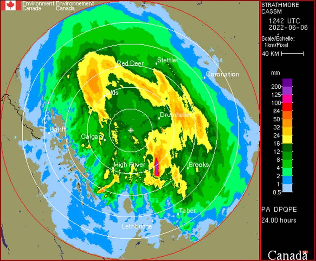
You're seeing that right; to Calgary’s southeast, between Lomond and Armada, Alta., there was well in excess of 100 millimetres of rain, as severe weather parked stationary over the region for at least five hours. This created localized flooding, with the dry ground unable to drink in the moisture fast enough.
More is on the way. In part due to yesterday's rain, some events will be severe thunderstorms.
The risk zone for significant weather runs in a band from Grande Prairie down through Lethbridge and Medicine Hat, parallel to the foothills. This includes a good chance for Calgary. Therein, heavy rain bands will couple with (up to) quarter-sized hail and the possibility of funnel clouds.
Local rain totals will exceed five millimetres, may exceed 10 mm, and could go as high as 15 mm, especially with the trigger of a storm. The major factor for your consideration today: while these storms are still possible in the later afternoon, their best chance of forming is the early afternoon. There is even potential before we've crested past noon.
When thunder roars, head indoors. The afternoon update of this article will come a touch earlier, today.
Showers will persist tomorrow, lighter than the offering expected today. The remainder of the week clears up.
YOUR FIVE-DAY CALGARY FORECAST
Monday
- Evening: showers, low 9 C
Tuesday
- Showers, then afternoon clearing
- Daytime high: 16 C
- Evening: some cloud, low 8 C
Wednesday
- Partly cloudy, chance of afternoon showers
- Daytime high: 18 C
- Evening: clear, low 6 C
Thursday
- Mainly sunny
- Daytime high: 21 C
- Evening: mainly cloudy, low 13 C
Friday
- Mainly cloudy
- Daytime high: 22 C
- Evening: mainly cloudy, low 13 C
Saturday
- Partly cloudy
- Daytime high: 24 C
- Evening: some cloud, low 11 C
In the wake of severe storms, if it's safe to do so, please share those pictures my way on Twitter, or to our Instagram at @CTVCalgaryWeather.
Today's pic was delivered by Don at Yamnuska, and it's a thing of beauty!
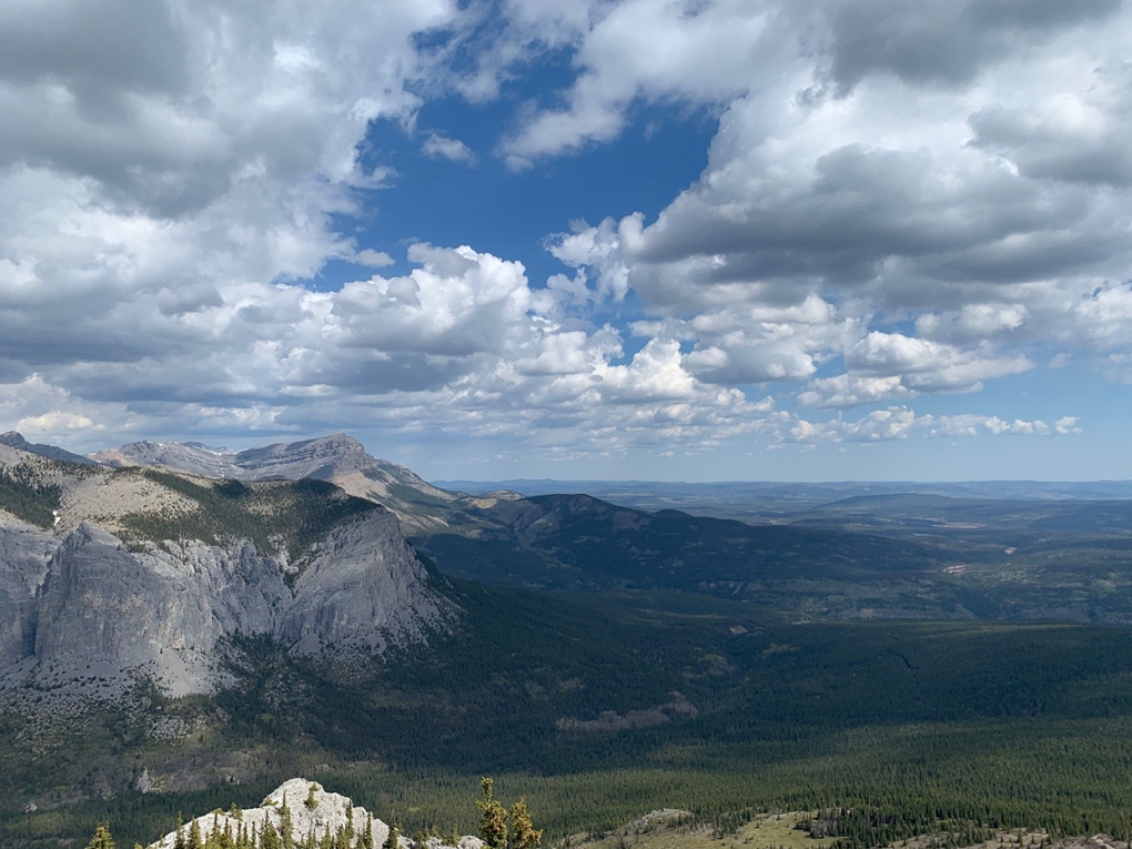 Viewer Don's photo from Yamnuska.
Submit your weather photos here to see them featured in our article, and perhaps even as the pic of the day during our News at Six!


CTVNews.ca Top Stories

Quebec nurse had to clean up after husband's death in Montreal hospital
On a night she should have been mourning, a nurse from Quebec's Laurentians region says she was forced to clean up her husband after he died at a hospital in Montreal.
'Anything to win': Trudeau says as Poilievre defends meeting protesters
Prime Minister Justin Trudeau is accusing Conservative Leader Pierre Poilievre of welcoming 'the support of conspiracy theorists and extremists,' after the Conservative leader was photographed meeting with protesters, which his office has defended.
'My stomach dropped': Winnipeg man speaks out after being criminally harassed following single online date
A Winnipeg man said a single date gone wrong led to years of criminal harassment, false arrests, stress and depression.
What is changing about Canada's capital gains tax and how does it impact me?
The federal government's proposed change to capital gains taxation is expected to increase taxes on investments and mainly affect wealthy Canadians and businesses. Here's what you need to know about the move.
Bank of Canada officials split on when to start cutting interest rates
Members of the Bank of Canada's governing council were split on how long the central bank should wait before it starts cutting interest rates when they met earlier this month.
Pilot reported fire onboard plane carrying fuel, attempted to return to Fairbanks just before crash
One of the two pilots aboard an airplane carrying fuel reported there was a fire on the airplane shortly before it crashed and burned outside Fairbanks, killing both people on board, a federal aviation official said Wednesday.
Police tangle with students in Texas and California as wave of campus protest against Gaza war grows
Police tangled with student demonstrators in Texas and California while new encampments sprouted Wednesday at Harvard and other colleges as school leaders sought ways to defuse a growing wave of pro-Palestinian protests.
'One of the single most terrifying things ever': Ontario couple among passengers on sinking tour boat in Dominican Republic
A Toronto couple are speaking out about their 'extremely dangerous' experience on board a sinking tour boat in the Dominican Republic last week.
7 surveillance videos linked to extortions of South Asian home builders in Edmonton released
The Edmonton Police Service has released a number of surveillance videos related to a series of extortion cases in the city now dubbed 'Project Gaslight.'
Shopping Trends
The Shopping Trends team is independent of the journalists at CTV News. We may earn a commission when you use our links to shop. Read about us.


Edmonton
-

Measles case in Edmonton prompts exposure warning
Alberta Health Services issued a measles alert in Edmonton Wednesday after confirming a case.
-
7 surveillance videos linked to extortions of South Asian home builders in Edmonton released
The Edmonton Police Service has released a number of surveillance videos related to a series of extortion cases in the city now dubbed 'Project Gaslight.'
-
8.9% property tax approved by Edmonton council
Edmonton city council unanimously agreed on an 8.9-per cent property tax increase Tuesday evening.
Lethbridge
-

Alberta, B.C. preparing for early start to wildfire season
Wildfires in Alberta and B.C. appear to be getting off to an early start this year. Both province's wildfire services are doing what they can to prepare for what's expected to be a tough summer.
-
Man sent to hospital with head injury following Lethbridge encampment assault
An assault over property at a Lethbridge encampment ended with a man in hospital suffering from a serious head injury.
-
Southern Alberta woman wins $2M on Western 6-49 lottery
A southern Alberta woman says she began to hyperventilate when she realized she had won $2 million.
Vancouver
-

'It was instant karma': Viral video captures failed theft attempt in Nanaimo, B.C.
Mounties in Nanaimo, B.C., say two late-night revellers are lucky their allegedly drunken antics weren't reported to police after security cameras captured the men trying to steal a heavy sign from a downtown business.
-
RCMP officers 'refused' to provide evidence to Crown to assist drug, firearms prosecution: report
Crown counsel was unable to approve "significant" drug and weapons charges stemming from an arrest in Quesnel, B.C., last year because the officers involved "refused to provide any evidence," according to a report from the province’s police watchdog.
-
B.C. man rescues starving dachshund trapped in carrier: BC SPCA
An emaciated dachshund is now recovering thanks to a Good Samaritan who found the pup near a biking trail in Kelowna, according to the BC SPCA.
Vancouver Island
-
'It was instant karma': Viral video captures failed theft attempt in Nanaimo, B.C.
Mounties in Nanaimo, B.C., say two late-night revellers are lucky their allegedly drunken antics weren't reported to police after security cameras captured the men trying to steal a heavy sign from a downtown business.
-
RCMP officers 'refused' to provide evidence to Crown to assist drug, firearms prosecution: report
Crown counsel was unable to approve "significant" drug and weapons charges stemming from an arrest in Quesnel, B.C., last year because the officers involved "refused to provide any evidence," according to a report from the province’s police watchdog.
-
B.C. man rescues starving dachshund trapped in carrier: BC SPCA
An emaciated dachshund is now recovering thanks to a Good Samaritan who found the pup near a biking trail in Kelowna, according to the BC SPCA.
Saskatoon
-

Sask. woman fights to find out who had her apprehended for a psych. assessment
A Saskatchewan woman who was taken for an involuntary mental health assessment is entitled to find out who had her committed, a provincial court judge has ruled.
-
Sask. judge sets date to decide if evidence in fatal THC-impaired driving case is admissible
A date has been set for a Saskatoon judge to decide whether a woman’s admission to consuming drugs can be used in her trial.
-
Punched, kicked, spat on: Saskatoon Transit workers call for help after violent assaults
The union representing the city’s bus drivers says violence against transit workers is out of control.
Regina
-

'Learn to walk again': Sask. doctor tells story of miracle recovery from deadly heart condition
It was a powerful morning at Regina's Conexus Arts Centre Wednesday, where the Lieutenant Governor hosted the annual Saskatchewan Prayer Breakfast and a provincial doctor told his story of survival from a deadly heart condition.
-
Throwing star, crossbow found during Sask. RCMP searches at George Gordon FN, Punnichy
A throwing star and crossbow were among the seizures by police as part of a drug trafficking investigation on George Gordon First Nation and in Punnichy, Sask. last week.
-
Sask. police caught 454 impaired drivers in March: SGI
Saskatchewan police caught 454 impaired drivers around the province in March. Of those, 142 are facing Criminal Code charges and the other 312 faced licence suspensions, according to a news release from Saskatchewan Government Insurance (SGI).
Toronto
-

Speed limits to increase on some sections of Ontario highways, province says
The Ontario government says it will be raising the speed limit along certain stretches of provincial highways soon, including Highway 401 and Highway 403.
-
New condo sales in the Toronto area hit low not seen since financial crisis
New condo sales in the Toronto region dropped to the lowest quarterly total since the financial crisis in 2009 amid high interest rates and affordability issues, a new report has found.
-
'One of the single most terrifying things ever': Ontario couple among passengers on sinking tour boat in Dominican Republic
A Toronto couple are speaking out about their 'extremely dangerous' experience on board a sinking tour boat in the Dominican Republic last week.
Montreal
-
Quebec nurse had to clean up after husband's death in Montreal hospital
On a night she should have been mourning, a nurse from Quebec's Laurentians region says she was forced to clean up her husband after he died at a hospital in Montreal.
-
REM delayed: Stations in West Island, North Shore now opening in 2025
Officials for Montreal's REM line confirmed that the lines to the West Island and the North Shore are being delayed and won't open until 2025.
-
Quebec grants $40 million for cleanup of Montreal Olympic Stadium after fire
The Quebec government has awarded the organization that manages Montreal's Olympic Stadium up to $40 million to pay for repairs and decontamination after a March 21 fire.
Atlantic
-

Funeral to be held Wednesday for 16-year-old Halifax homicide victim
A funeral will be held Wednesday afternoon in Bedford, N.S., for a 16-year-old boy who died earlier this week following an incident near the Halifax Shopping Centre.
-
N.S. man wins $1.5M through Atlantic Lottery
A Cape Breton man won $1.5 million after buying $200-worth of Atlantic Lottery Scratch’N Win tickets.
-
Police presence at Lower, Middle Sackville, N.S., schools Wednesday afternoon
RCMP officers were seen at three schools in Lower and Middle Sackville, N.S., Wednesday afternoon.
Winnipeg
-

Manitoba government tables bill to end ban on homegrown recreational cannabis
Manitoba is planning to lift its ban on the home growing of recreational cannabis.
-
'I just wanted to stand out': Winnipeg Jets fan goes viral for wearing salmon shirt at Whiteout
A Winnipeg Jets fan found a unique way to stand out amid the Winnipeg Whiteout; he wore a salmon-coloured shirt.
-
Child dies following collision with trailer: Brandon police
A four-year-old child has died following a collision with a trailer in Brandon, Man.
Ottawa
-

NCC buys golf course near Gatineau Park for $3.9 million
The National Capital Commission has purchased the old Dunnderosa Golf Course in Chelsea, Que., as part of its plan to acquire private properties in Gatineau Park.
-
Residents raise concerns about plan for Inuit women's shelter in Ottawa's south end
Residents in Ottawa's Hunt Club neighbourhood are raising concerns about plans to build an Inuit women's shelter in the south end neighbourhood.
-
Eastern Ont. knitters make 80 peacekeeper 'Izzy Dolls' for D-Day anniversary
Volunteers in Perth, Ont. have knit small peacekeeper "Izzy Dolls" that will be sent to France in commemoration of the 80th anniversary of D-Day and the Battle of Normandy.
Northern Ontario
-

Northern Ont. lawyer who abandoned clients in child protection cases disbarred
A North Bay, Ont., lawyer who abandoned 15 clients – many of them child protection cases – has lost his licence to practise law.
-
'My stomach dropped': Winnipeg man speaks out after being criminally harassed following single online date
A Winnipeg man said a single date gone wrong led to years of criminal harassment, false arrests, stress and depression.
-
OPP and Treaty Three police lay murder charge in northwestern Ont.
The Ontario Provincial Police, in partnership with the Treaty Three Police Service, have charged a suspect with murder following a homicide in a remote northwestern Ontario community.
Barrie
-

Suspected remains of missing Thornbury man found six years after disappearance
It was mid-October 2018 when Eric Spencer was last seen in Honey Harbour, a full-scale search by the OPP for the then 60-year-old from Thornbury scaled back when the search came up empty.
-
U.S. Marshals join search for Wasaga Beach kidnapping suspect
U.S. Marshals joins search for Deshawn Davis, one of Canada’s most wanted, accused of the kidnapping of Elnaz Hajtamiri in Wasaga Beach January 2022 and the suspect in a nightclub shooting that took place in May of last year.
-
Video surveillance footage reveals bizarre break-in at local vet hospital
Barrie Police laid charges on a man after video surveillance captured him breaking into a store and smashing the front glass door.
Kitchener
-

Film crews transform Cambridge pizza shop
Expect delays on Queen Street in Cambridge today as film crew shoots in the area.
-
Pedestrian seriously hurt after crash in Kitchener
A pedestrian had to be taken to an out-of-region hospital following a crash in Kitchener.
-
Grand River and St. Mary's hospitals could merge in 2025
Grand River Hospital and St. Mary’s General Hospital are looking to merge into a single new hospital organization by the spring of 2025.
London
-

Nuclear waste referendum date set for October
Residents in the Municipality of South Bruce will decide whether they want to host Canada’s first permanent nuclear waste storage facility this October.
-
How do U.S. decisions about TikTok impact Canada?
U.S. President Joe Biden has signed a bill that will force TikTok to be sold or be banned in his country, but what does it mean for Canada?
-
'I think 110 is fast enough': Speed limit to increase on some sections of 400 series highways
The speed you travel on sections of 400 series highways in our region is increasing. The province says it will raise the speed limit to 110 km/h on multiple sections, including some in the London region.
Windsor
-
 BREAKING
BREAKING Convicted killer can ask for parole now: Windsor, Ont. jury accepts 'faint hope' application
A Windsor man convicted in a violent murder 20 years ago was successful in his ‘faint hope’ bid for an early chance at freedom after a jury agreed he should be given the chance to apply for early parole eligibility.
-
Essex concert series needs to pay its performers, say local musicians
If musicians are the sole focus of a commercial event, those performers should be paid for their efforts. That's according to a local musician who set up an online petition after the Town of Essex issued a call for artists to perform at their annual summer concert series for free.
-
Witnesses sought after Porsche and motorcycle collide
The Windsor Police Collision Reconstruction Unit is looking for witnesses after a collision involving a motorcycle and a Porsche.


