Storm risk for Calgary Wednesday afternoon/evening
AFTERNOON UPDATE: For their part, showers have subsided. What we're left with is trace potential through the mid-afternoon, and a very small chance of showers later this evening. If it's anything, it won't be a heck of a lot. Tomorrow still holds to thundershower potential, with a rather small amount of attached rainfall; these will be pocket storms rolling free of the foothills.
MORNING EDITION: An extremely eventful day yesterday. Let’s start here:
Among a number of funnel clouds, a short-lived, extremely isolated tornado looks to have done some damage. I imagine there's a decent chance that an official agency heads out that way sometime today to investigate this. Until then, there won't be an official update on whether this was a tornado or not.
We had loads of energy yesterday for storms, but we lacked strong wind shear — the vertical force that enhances storm strength. When there's a lot of energy and limited uplift, you achieve two major factors: one, the huge cumulus towers that make up these storms can sometimes lower a brief vortex below the cloud ceiling; AKA, a funnel cloud. Some of these can even touch down. The second effect is hail; hail requires a strong updraft within the storm to grow large, and without it, abundant pea-sized hail is likely. That's what we saw through parts of our city yesterday, resulting in this:
It's a protective instinct to take shelter in a hailstorm, but it's exponentially more dangerous in low visibility to stop on the road in these circumstances. Luckily, this didn’t result in any collisions.
This brings us to the present; Sunday, we had 10.9 millimetres of rain. That was the wettest day of the year. Yesterday, we topped it; 24.2 mm. Overnight, the rain kept going. Here's the last 24 hours:
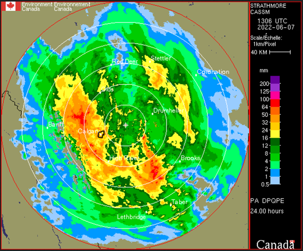
I circled Calgary. Sustained showers to the northwest yesterday afternoon and overnight resulted in over 60 mm coming down. This likely wraps just after the noon hour.
Tomorrow, a brief resurgence of moisture may result in thundershowers. Then, the jet stream tilts a wee bit further to the south, giving us a southwesterly profile, and a much warmer – and drier – lead-up heading into the weekend.
I mentioned in our seven-day trend yesterday that a drop was coming for Sunday, leading into more rain; that's now begun to materialize on Saturday afternoon. There's still a chance it falls back; it's a ways off, yet.
YOUR FIVE-DAY CALGARY FORECAST
Tuesday
- Evening: some cloud, low 7 C
Wednesday
- Partly cloudy, chance of afternoon thundershowers
- Daytime high: 21 C
- Evening: clear, low 7 C
Thursday
- Mainly sunny
- Daytime high: 23 C
- Evening: mainly cloudy, low 13 C
Friday
- Partly cloudy
- Daytime high: 23 C
- Evening: mainly cloudy, low 13 C
Saturday
- Partly cloudy, chance of afternoon showers
- Daytime high: 19 C
- Evening: cloudy, chance of showers low 11 C
Sunday
- Mainly cloudy, showers
- Daytime high: 17 C
- Evening: cloudy, chance of showers low 11 C
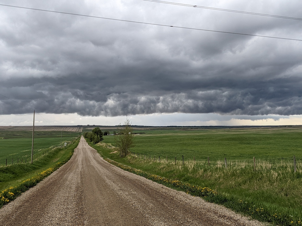
Today's pic was sent by Vince. The initial frontal boundary for yesterday's activity was a stationary front, where the warm and cold air masses hung together; that creates quite the cloud display!
Submit your weather photos here to see them featured in our article, and perhaps even as the pic of the day during our News at Six! You can also share my way on Twitter, or to our Instagram at @CTVCalgaryWeather.


CTVNews.ca Top Stories

'They needed people inside Air Canada:' Police announce arrests in Pearson gold heist
Police say one former and one current employee of Air Canada are among the nine suspects that are facing charges in connection with the gold heist at Pearson International Airport last year.
House admonishes ArriveCan contractor in rare parliamentary show of power
MPs enacted an extraordinary, rarely used parliamentary power on Wednesday, summonsing an ArriveCan contractor to appear before the House of Commons where he was admonished publicly and forced to provide answers to the questions MPs said he'd previously evaded.
Leafs star Auston Matthews finishes season with 69 goals
Auston Matthews won't be joining the NHL's 70-goal club this season.
Trump lawyers say Stormy Daniels refused subpoena outside a Brooklyn bar, papers left 'at her feet'
Donald Trump's legal team says it tried serving Stormy Daniels a subpoena as she arrived for an event at a bar in Brooklyn last month, but the porn actor, who is expected to be a witness at the former president's criminal trial, refused to take it and walked away.
Why drivers in Eastern Canada could see big gas price spikes, and other Canadians won't
Drivers in Eastern Canada face a big increase in gas prices because of various factors, especially the higher cost of the summer blend, industry analysts say.
Doug Ford calls on Ontario Speaker to reverse Queen's Park keffiyeh ban
Ontario Premier Doug Ford is calling on Speaker Ted Arnott to reverse a ban on keffiyehs at Queen's Park, describing the move as “needlessly” divisive.
'A living nightmare': Winnipeg woman sentenced following campaign of harassment against man after online date
A Winnipeg woman was sentenced to house arrest after a single date with a man she met online culminated in her harassing him for years, and spurred false allegations which resulted in the innocent man being arrested three times.
Woman who pressured boyfriend to kill his ex in 2000s granted absences from prison
A woman who pressured her boyfriend into killing his teenage ex more than a decade ago will be allowed to leave prison for weeks at a time.
Customers disappointed after email listing $60K Tim Hortons prize sent in error
Several Tim Horton’s customers are feeling great disappointment after being told by the company that an email stating they won a boat worth nearly $60,000 was sent in error.
Shopping Trends
The Shopping Trends team is independent of the journalists at CTV News. We may earn a commission when you use our links to shop. Read about us.


Edmonton
-
More than 150 people reported crashes in Edmonton Wednesday
More than 150 people have reported vehicle crashes in Edmonton on Wednesday.
-
Oilers a fitting opponent for what could be Coyotes' last game in Arizona
In at least a couple of ways, it's fitting the Edmonton Oilers will be the Arizona Coyotes' final opponent before the Desert Dogs shed their Kachina-styled uniforms for whatever hues and themes may await them in Salt Lake City.
-
Spring snow stalls golfers but moisture welcomed by courses and fire crews
While snow and ice aren't ideal weather for hitting the links, a local golf course said it's happy to see some April precipitation.
Lethbridge
-

Deterrent sentence possible, expert says, after trio convicted in connection to Coutts border blockade
Three men who helped lead and co-ordinate the 2022 border blockade at Coutts, Alta., have been found guilty of public mischief.
-
Central Alberta man arrested in connection with grandparent scam
Lethbridge police have arrested a Vermilion, Alta., man in connection with a 'grandparent scam' that took aim at a local senior.
-
Woman, 61, killed in crash north of Coaldale, Alta.: RCMP
An Alberta woman was killed in a multi-vehicle crash on a highway north of Coaldale, Alta., on Wednesday morning.
Vancouver
-

B.C. child killer's lawyer walks out of review hearing
The lawyer representing child-killer Allan Schoenborn walked out of his client's annual review hearing Wednesday – abruptly ending proceedings marked by tense exchanges and several outbursts.
-
Police investigating daredevil videos of 'urban climber' in Vancouver
A social media daredevil has been doing death-defying stunts in the Vancouver area, prompting safety concerns and at least one police investigation.
-
Truck driver airlifted to hospital after head-on collision with school bus: Mission RCMP
The driver of a pickup truck was airlifted to hospital after a head-on collision with a school bus outside Mission on Wednesday afternoon, according to authorities.
Vancouver Island
-
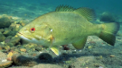
B.C. asks anglers to help eradicate this sport fish common in the rest of Canada
The British Columbia government is encouraging anglers to pack their tackle boxes and head out to a remote lake on Vancouver Island as the province attempts to eradicate an invasive population of sport fish.
-
Parents fighting to save unique Mill Bay school from returning to catchment pool
Evan Jamieson’s nine-year-old son Oliver has thrived at Mill Bay Nature School in Mill Bay, B.C., despite all of his challenges.
-
No connection between police response, man's death near Vancouver Island trail: IIO
B.C.'s police watchdog has finished its investigation into an incident on Vancouver Island, concluding the actions of officers weren't connected to a man's death.
Saskatoon
-

Sask. woman accused of driving while high in fatal crash takes the stand
The woman accused of hitting and killing a child while driving under the influence of THC was called to the stand on Wednesday.
-
Government, STF reach tentative agreement, members to vote
After two days of negotiations, the province has presented the Saskatchewan Teachers’ Federation (STF) a final offer, which will go to members for a vote.
-
Former Sask. massage therapist who sexually assaulted clients has day parole revoked
A former massage therapist who pleaded guilty to a string of sexual assaults has had his day parole revoked.
Regina
-

Government, STF reach tentative agreement, members to vote
After two days of negotiations, the province has presented the Saskatchewan Teachers’ Federation (STF) a final offer, which will go to members for a vote.
-
Regina man says he was wrongfully evicted from seniors' facility and left with nowhere to go
A Regina man who says he was given two hours to vacate the seniors' home he lived in after being evicted should not have been forced to move in the first place.
-
SUMA conference concludes with bear pit session
The Saskatchewan Urban Municipalities Association (SUMA) conference wrapped up on Wednesday with educational sessions in the morning, followed by a bear pit session for delegates to speak directly with the provincial government.
Toronto
-

Doug Ford calls on Ontario Speaker to reverse Queen's Park keffiyeh ban
Ontario Premier Doug Ford is calling on Speaker Ted Arnott to reverse a ban on keffiyehs at Queen's Park, describing the move as “needlessly” divisive.
-
'They needed people inside Air Canada:' Police announce arrests in Pearson gold heist
Police say one former and one current employee of Air Canada are among the nine suspects that are facing charges in connection with the gold heist at Pearson International Airport last year.
-
Leafs star Auston Matthews finishes season with 69 goals
Auston Matthews won't be joining the NHL's 70-goal club this season.
Montreal
-

Legault still doesn't know the price of a 4 1/2 in Montreal
François Legault still doesn't know the price of a 4 1/2 apartment in Montreal, three years after getting bogged down on the issue.
-
Quebec says education ministry presentation for parents could have been in English after all
In the latest example of the confusion surrounding Quebec's new language law, the education ministry has confirmed that a presentation delivered only in French to English-speaking parents last week could have been done in English after all.
-
Montreal police open fire on driver in suspected stolen vehicle intervention
Quebec's police watchdog has opened an investigation into a Montreal police (SPVM) intervention in the Côte-des-Neiges–Notre-Dame-de-Grâce borough that ended with one person seriously injured.
Atlantic
-
N.S. RCMP investigating sudden death in Bass River
The RCMP says it is investigating a sudden death in Nova Scotia’s Colchester County.
-
Why drivers in Eastern Canada could see big gas price spikes, and other Canadians won't
Drivers in Eastern Canada face a big increase in gas prices because of various factors, especially the higher cost of the summer blend, industry analysts say.
-
500 Newfoundlanders wound up on the same cruise and it turned into a rocking kitchen party
A Celebrity Apex cruise to the Caribbean this month turned into a rocking Newfoundland kitchen party when hundreds of people from Canada's easternmost province happened to be booked on the same ship.
Winnipeg
-

'Totally wrong': Winnipeg man says landlord denied life-changing medical equipment
A Winnipeg man is raising a red flag after his landlord said no to health-care equipment that could change his life – a problem he believes is a human rights issue.
-
Attempt to have murder charge quashed against alleged serial killer dismissed by judge
A motion filed by the man accused of killing four Indigenous women in Winnipeg to have one of those murder charges quashed has been dismissed by the judge – weeks before the start of his trial.
-
Missing woman last seen in Brandon
RCMP say they are concerned for the wellbeing of a missing 35-year-old woman.
Ottawa
-
 NEW THIS MORNING
NEW THIS MORNING Sens clean out their lockers as another season ends without a playoff run
This is the seventh season in a row the Senators failed to qualify for the NHL playoffs. The Sens finished the season with a record of 37-41-4, wrapping up the season Tuesday night against the Boston Bruins with one last win.
-
GAS PRICES
GAS PRICES Ottawa gas prices expected to increase 14 cents a litre on Thursday
Ottawa motorists are being warned to expect a big hike in gasoline prices this week, as prices rise to the highest level since August 2022.
-
'We'd like to see it move faster': The push to increase activity in downtown Ottawa
Talk of transitioning federal buildings into housing has been in the works for a couple of years and it's a move that business leaders in Ottawa say can't come soon enough.
Northern Ontario
-

$200M arena decision ‘a big step’ for Sudbury’s future, mayor says
In a lengthy council meeting Tuesday night, city council in Sudbury unanimously voted to build a new arena and events centre downtown.
-
Sudbury murder suspect talked about his role in ‘his girl’ getting hurt, witness testifies
A former girlfriend of a murder suspect in Sudbury testified Wednesday that he talked about his role in the deaths a day after a firebombing that killed three people.
-
Body of missing man found, northern Ontario police say
The body of a missing man has been found after his vehicle was pulled into a northern creek on Saturday morning, Ontario Provincial Police say.
Barrie
-

Death investigation launched after body washes onto Lake Couchiching shore
Provincial police are investigating after a man's body washed up on the shores of Lake Couchiching in Severn Township.
-
Tim Hortons Roll Up The Rim contest faces backlash amid another ‘technical error’
Tim Hortons Roll Up The Rim contest may be in hot water yet again after several customers received emails falsely congratulating them on winning the Tracker boat worth nearly $60,000.
-
Multi-vehicle collision involving a semi-truck halts traffic
A multi-vehicle collision involving a semi-truck snarled traffic in Barrie on Wednesday afternoon.
Kitchener
-

Police services board wants new approach to St. Patrick's Day
The Waterloo Region Police Services Board wants to explore new ways of dealing with an annual unsanctioned St. Patrick’s Day street party in Waterloo’s University District.
-
'They needed people inside Air Canada:' Police announce arrests in Pearson gold heist
Police say one former and one current employee of Air Canada are among the nine suspects that are facing charges in connection with the gold heist at Pearson International Airport last year.
-
KW Titans need more fans to break even
Despite being at the top of the Basketball Super League standings, the KW Titans are struggling to make ends meet.
London
-

'Everyone is devastated': Hockey community mourns loss of young leader
The hockey community in Chatham-Kent and beyond is mourning the sudden death of a player caught in a highway crash this week in London.
-
New smart washroom the talk of Grand Bend
It’s not every day that a new washroom becomes the talk of the town. But in the Lake Huron tourist community of Grand Bend a new so-called smart washroom has many residents and business owners flush with joy.
-
Western named 'academic partner' by Canadian Nuclear Isotope Council
The Canadian Nuclear Isotope Council has named Western University an academic partner.
Windsor
-
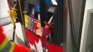
Gas prices set to rise 'dramatically' Thursday
Many made a dash to the pumps because experts say the price of gas is set to rise Thursday.
-
'Everyone is devastated': Hockey community mourns loss of young leader
The hockey community in Chatham-Kent and beyond is mourning the sudden death of a player caught in a highway crash this week in London.
-
Parents advocate for 'certainty' amidst 'stressful' review of special education program
Parents of children with learning disabilities are seeking 'certainty' on the long-term status of a program that provides tailored special education support in language and math within schools.


