Uptrending into the high teens this weekend in Calgary
CALGARY -
I regret to inform you that the next few articles may be shorter. If you subscribe to the idea that "less news is probably good news," you're right!
West wind off of the foothills piles in over the next two days, potentially triggering warning conditions to the southwest – the better shot for this is tomorrow. Those who deal with pressure sensitivities may not be a huge fan of these adjustments.
Beyond, it's sublime warming conditions for the weekend, as a ridge of high pressure jumps in on the westerly setup. While it won't equal to the start of the month – where we popped into the 20s – it will still strike for the high teens.
These calmer conditions will abate Monday, with a pressing wave of cooler, northern air dropping us closer to normal. Beyond the slump to start our next work week, longer-range conditions aim to hold steady near normal.

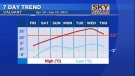
YOUR FIVE-DAY FORECAST
Today:
- Sunny, windy! Gusts W 40 km/h
- Daytime high: 10 C
- Evening: mainly clear, low 0 C
Friday:
- Mainly sunny
- Daytime high: 14 C
- Evening: mainly clear, low 1 C
Saturday:
- Sunny
- Daytime high: 16 C
- Evening: mainly clear, low 5 C
Sunday:
- Sunny
- Daytime high: 18 C
- Evening: mainly clear, low 2 C
Monday:
- Mostly cloudy
- Daytime high: 8 CEvening: mainly cloudy, low -3 C
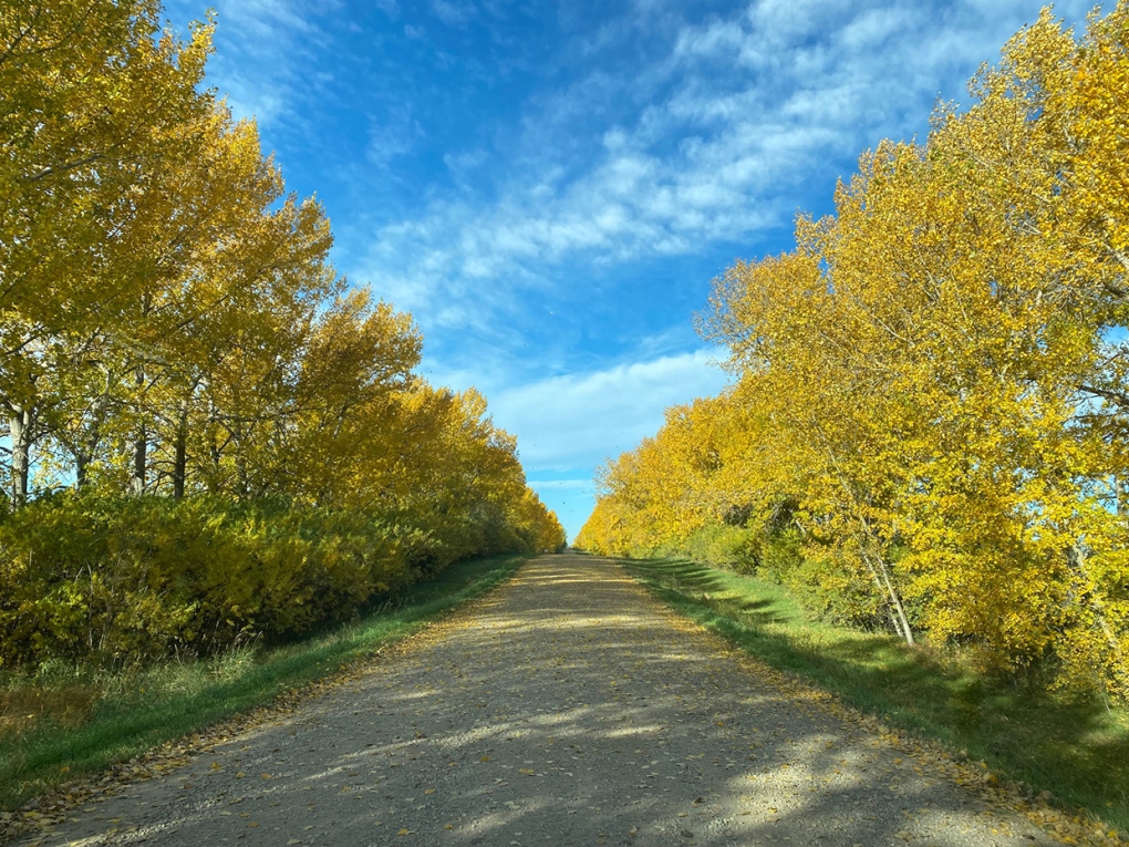
Quentin's photo west of Stettler takes the cake today:
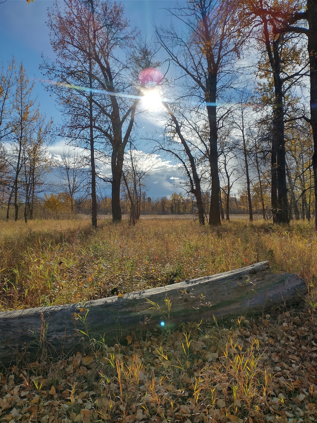
Then, Dave went to Fish Creek Park and earned a spot here, too:
You can submit your photos here, email me directly here, or tweet them over!


CTVNews.ca Top Stories
DEVELOPING
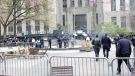
DEVELOPING Person on fire outside Trump's hush money trial rushed away on a stretcher
A person who was on fire in a park outside the New York courthouse where Donald Trump’s hush money trial is taking place has been rushed away on a stretcher.
Mandisa, Grammy award-winning 'American Idol' alum, dead at 47
Soulful gospel artist Mandisa, a Grammy-winning singer who got her start as a contestant on 'American Idol' in 2006, has died, according to a statement on her verified social media. She was 47.
She set out to find a husband in a year. Then she matched with a guy on a dating app on the other side of the world
Scottish comedian Samantha Hannah was working on a comedy show about finding a husband when Toby Hunter came into her life. What happened next surprised them both.
'It could be catastrophic': Woman says natural supplement contained hidden painkiller drug
A Manitoba woman thought she found a miracle natural supplement, but said a hidden ingredient wreaked havoc on her health.
Vicious attack on a dog ends with charges for northern Ont. suspect
Police in Sault Ste. Marie charged a 22-year-old man with animal cruelty following an attack on a dog Thursday morning.
Senators reject field trip to African Lion Safari amid elephant bill study
The Senate legal affairs committee has rejected a motion calling for members to take a $50,000 field trip to the African Lion Safari in southern Ontario to see the zoo's elephant exhibit.
DEVELOPING
DEVELOPING G7 warns of new sanctions against Iran as world reacts to apparent Israeli drone attack
Group of Seven foreign ministers warned of new sanctions against Iran on Friday for its drone and missile attack on Israel, and urged both sides to avoid an escalation of the conflict.
Police in Paris detain a man wearing fake explosives vest at Iran's Consulate
A man wearing a fake explosive vest and making threats was detained Friday outside the Iranian Consulate in Paris after police locked down the area, authorities said. His motive was unclear.
CFIA monitoring for avian flu in Canadian dairy cattle after U.S. discoveries
The Canadian Food Inspection Agency is encouraging veterinarians to keep an eye out for signs of avian influenza in dairy cattle following recent discoveries of cases of the disease in U.S. cow herds.
Shopping Trends
The Shopping Trends team is independent of the journalists at CTV News. We may earn a commission when you use our links to shop. Read about us.


Edmonton
-

Oilers host Los Angeles Kings on Monday in Game 1 of playoffs
The National Hockey League has confirmed the schedule for the first four Edmonton Oilers playoff games.
-
Voluntary water limits put in place in face of possible Alberta drought
More than three dozen of Alberta's largest water users have agreed with a provincial plan to cut back on water usage this year ahead of a severe drought expected this summer.
-
Worker dies after fall at north Edmonton construction site
Occupational Health and Safety (OHS) is investigating after a worker fell to their death earlier this week.
Lethbridge
-

Medicine Hat woman charged after $60K stolen from Redcliff Legion
Mounties say a 32-year-old Medicine Hat woman has been charged in connection with the theft of $60,000 from the Redcliff Legion.
-
Deterrent sentence possible, expert says, after trio convicted in connection to Coutts border blockade
Three men who helped lead and co-ordinate the 2022 border blockade at Coutts, Alta., have been found guilty of public mischief.
-
Central Alberta man arrested in connection with grandparent scam
Lethbridge police have arrested a Vermilion, Alta., man in connection with a 'grandparent scam' that took aim at a local senior.
Vancouver
-
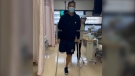
Vancouver firefighter in rehab at home after losing leg to flesh-eating infection overseas
A family trip took a frightening turn for Christopher Won when he was diagnosed with flesh-eating disease while in Hong Kong and now, after weeks of treatment overseas, the Vancouver firefighter is back home recovering.
-
Woman killed, driver sought after hit-and-run crash in Duncan, B.C.
A woman is dead and police are searching for a suspect driver after a hit-and-run crash in Duncan, B.C.
-
Coroner's inquest called into death of man killed in police shootout in Kamloops, B.C.
The British Columbia government has called for a coroner's inquest into the death of a 35-year-old Kamloops man who was killed in a shootout with police nearly six years ago.
Vancouver Island
-

Woman killed, driver sought after hit-and-run crash in Duncan, B.C.
A woman is dead and police are searching for a suspect driver after a hit-and-run crash in Duncan, B.C.
-
Off-duty Mountie cleared of wrongdoing after cyclist seriously injured in Langford, B.C.
British Columbia's police watchdog has cleared an off-duty Mountie of wrongdoing after a cyclist suffered serious injuries in a collision with an unmarked police vehicle last month.
-
Coroner's inquest called into death of man killed in police shootout in Kamloops, B.C.
The British Columbia government has called for a coroner's inquest into the death of a 35-year-old Kamloops man who was killed in a shootout with police nearly six years ago.
Saskatoon
-

Saskatoon library closed after employee assaulted by two teen girls
Carlyle King Library remains closed following an incident on Monday where an employee was assaulted by two teen girls.
-
Saskatoon police committing three officers to curb crime in Pleasant Hill
The Saskatoon Police Service (SPS) is dedicating three officers to a specialized unit to help curb crime in the Pleasant Hill neighbourhood.
-
New Sask. dental hygienist degree program to offer strictly evening classes
A new dental hygienist degree program is launching at the University of Saskatchewan (U of S) in September to help meet a growing demand for oral health specialists.
Regina
-

Jury deliberations underway for Sask. father accused of abducting daughter
Following two full weeks of proceedings, a Regina judge ordered a 12 person jury to deliberate their decision for Michael Gordon Jackson.
-
New crash course focused on getting Sask. youth excited about journalism
Fifteen youth from a variety of backgrounds are taking on the monumental task of creating and performing a live radio broadcast with on seven days to prepare. The goal of the project is to get more youth excited about journalism.
-
SaskPower investing $13.5M in Regina's downtown electrical grid
SaskPower says it will be investing $13.5 million in an effort to improve downtown Regina's electrical grid.
Toronto
-
 WATCH
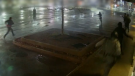
WATCHWATCH Video shows dramatic police takedown of carjacking suspects chased through parking lot north of Toronto
Police have released video footage of a dramatic takedown of a group of teens wanted in connection with an attempted carjacking in Markham earlier this month.
-
TTC service could be disrupted Monday if electrical and trades strike, CEO warns
The head of the TTC is warning of possible impacts to service on Monday if the union representing a group of more than 650 electrical and trades workers moves ahead with a strike.
-
'It was all my savings': Ontario woman loses $15K to fake Walmart job scam
A woman who recently moved to Canada from India was searching for a job when she got caught in an online job scam and lost $15,000.
Montreal
-

Young people 'tortured' if stolen vehicle operations fail, Montreal police tell MPs
One day after a Montreal police officer fired gunshots at a suspect in a stolen vehicle, senior officers were telling parliamentarians that organized crime groups are recruiting people as young as 15 in the city to steal cars so that they can be shipped overseas.
-
Woman stabbed at motel in Montreal's west end
A 39-year-old woman was sent to hospital with serious injuries after police say she was stabbed inside a motel room in Montreal's west end Friday morning.
-
Next leader of Quebec Liberals will be known on June 14, 2025
The next leader of the Quebec Liberal Party will be known on June 14, 2025, according to a news release on the party's website.
Atlantic
-
'Dangerous man' with firearm in Bible Hill in custody: N.S. RCMP
The RCMP says a 'dangerous man' with a firearm in Bible Hill, N.S., is in custody Friday morning.
-
Lyrid meteor shower nears peak; viewing opportunities in the Maritimes
CTV Atlantic meteorologist Kalin Mitchell says a large part of the Maritimes should have ideal viewing conditions for the Lyrid meteor shower Sunday overnight into Monday morning.
-
Privacy breach at Nova Scotia Health impacts more than 2,000 people
A former employee at St. Martha’s Regional Hospital, in Antigonish, N.S., inappropriately accessed the personal health information of 2,690 people, according to a news release from Nova Scotia Health.
Winnipeg
-

'It could be catastrophic': Woman says natural supplement contained hidden painkiller drug
A Manitoba woman thought she found a miracle natural supplement, but said a hidden ingredient wreaked havoc on her health.
-
Winnipeg Jets release Round 1 playoff schedule
The Winnipeg Jets have released its first round playoff schedule.
-
Winnipeg woman in hospital after being hit by tractor-trailer
One woman is in hospital after being hit by a tractor-trailer on Thursday night in North Kildonan.
Ottawa
-

Tropical fish stolen from Beachburg, Ont. restaurant found and returned
Ontario Provincial Police have landed a suspect following a fishy theft in Beachburg, Ont.
-
OPP reminds drone operators it's illegal to operate a drone near emergency sites following Hwy. 417 fatal crash
Ontario Provincial Police are reminding people that it is illegal to fly a drone over traffic collision sites, after drone footage captured over a fatal crash on Hwy. 417 in Ottawa appeared online.
-
Ottawa Humane Society drops senior cat adoption fee
It’s cheaper to adopt a senior cat now, as the Ottawa Humane Society has removed the adoption fee for all cats six years old and up.
Northern Ontario
-
Vicious attack on a dog ends with charges for northern Ont. suspect
Police in Sault Ste. Marie charged a 22-year-old man with animal cruelty following an attack on a dog Thursday morning.
-
DEVELOPING
DEVELOPING Person on fire outside Trump's hush money trial rushed away on a stretcher
A person who was on fire in a park outside the New York courthouse where Donald Trump’s hush money trial is taking place has been rushed away on a stretcher.
-
Driver suffered medical emergency in fatal Highway 17 crash
One person has died as the result of a single-vehicle crash at a northern Ontario business on Highway 17 on Thursday afternoon, police say.
Barrie
-

Serious rollover on Highway 400 sends mother to hospital
Person airlifted to Toronto after a rollover on Highway 400 Friday morning.
-
Court hearing for former NHLer and Barrie police officer facing extortion charges
Barrie police Insp. Valarie Gates testified in the preliminary hearing for suspended Sgt. Bruce Gardiner, who stands charged with extortion and criminal harassment.
-
Break-in leaves Barrie home with considerable water damage
Police are hoping to identify the person(s) who allegedly broke into a Barrie home and caused extensive water damage.
Kitchener
-

KW Glee, music school suspend employee over sexual assault charge
Two Kitchener-Waterloo music organizations have placed an employee on a leave of absence after he was charged in a historical sexual assault investigation.
-
NDP compares proposed Wilmot land acquisition to Green Belt scandal ahead of town hall
Ontario NDP leader Marit Stiles is in Wilmot Township today railing against a plan to turn 770-acres of farmland into an industrial site.
-
Landlords reporting increase in tenants refusing to pay rent or leave
A property management company in Fergus is still cleaning up after they say a tenant trashed one of their units and refused to pay rent -- and they say it's not the only similar case they've dealt with recently.
London
-
$80-million agreement for Central Elgin over annexed land for Volkswagen plant
The $80-million agreement announced Friday is said to include monetary compensation and infrastructure to grow industrial and residential tax bases.
-
Two people arrested in Port Elgin after vehicle theft in Hanover
Police in Hanover and Saugeen Shores have made an arrest after a citizen recognized a stolen vehicle from a social media post.
-
Human trafficking-related charges laid by London police
London police have charged a man from Manitoba with human trafficking-related charges. Police in the 600 block of Wellington Rd. near Wilkins Street when they saw a vehicle with stolen plates in a parking lot.
Windsor
-
Body recovered from Detroit River
An investigation is underway after a body was pulled from the Detroit River.
-
Threat investigated at Walkerville Collegiate
Windsor police are investigating a threat at a Walkerville high school.
-
56 tickets issued in Windsor police traffic blitz
Windsor police handed out 56 tickets during their latest traffic blitz.


