More rain expected in southern Alberta on Tuesday
Intense thunderstorms rolled through southern Alberta on Monday, producing damaging hail and strong winds.
According to Environment and Climate Change Canada (ECCC), baseball-sized hailstones fell in the hamlet of of Queenstown, tennis-ball sized hail fell near Mossleigh, egg-sized hail fell in Calgary and Cochrane, golf ball-size hail in Lyalta and Strathmore, ping pong ball-sized hail fell in Lake Louise, Toonie-sized hail fell in Delacour and nickel-sized hail fell in Okotoks.
Winds were also very strong with ECCC reporting peak gusts of 100 km/h near Tilley, 93 km/h near Mossleigh and 89 km/h in Diamond Valley.
Unusually large rainfall amounts also fell.
Public data on the ECCC forecast page for Calgary shows 52.7 mm of rain fell on Monday (that does not include rainfall accumulations after midnight).
This appears to be a record amount of precipitation for Calgary for Aug. 5, the next highest total for that day was 29 mm in 1962.
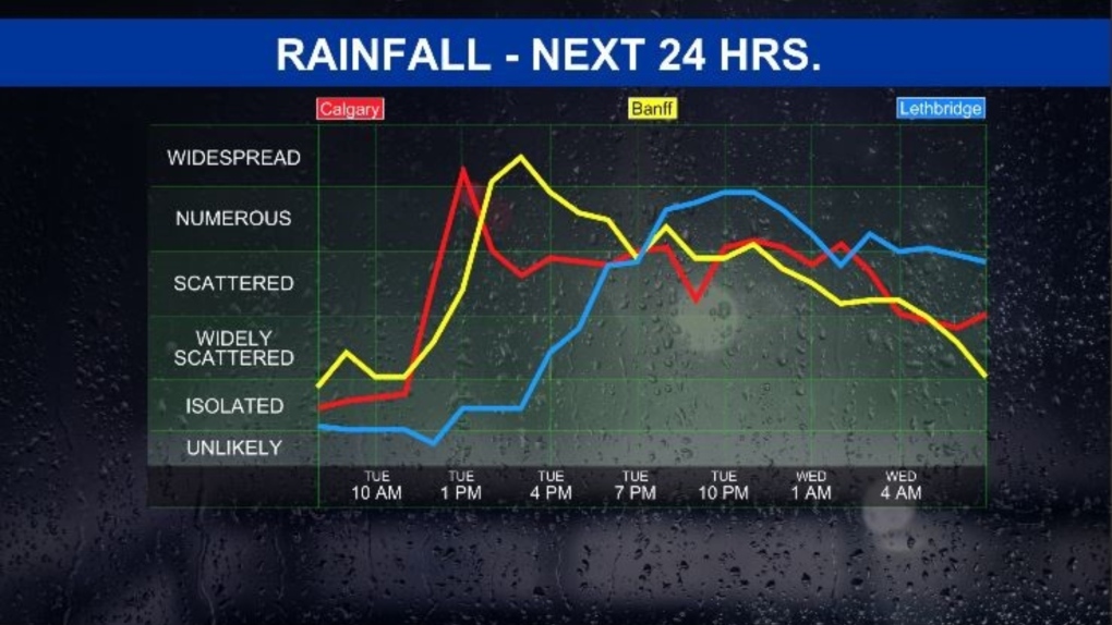
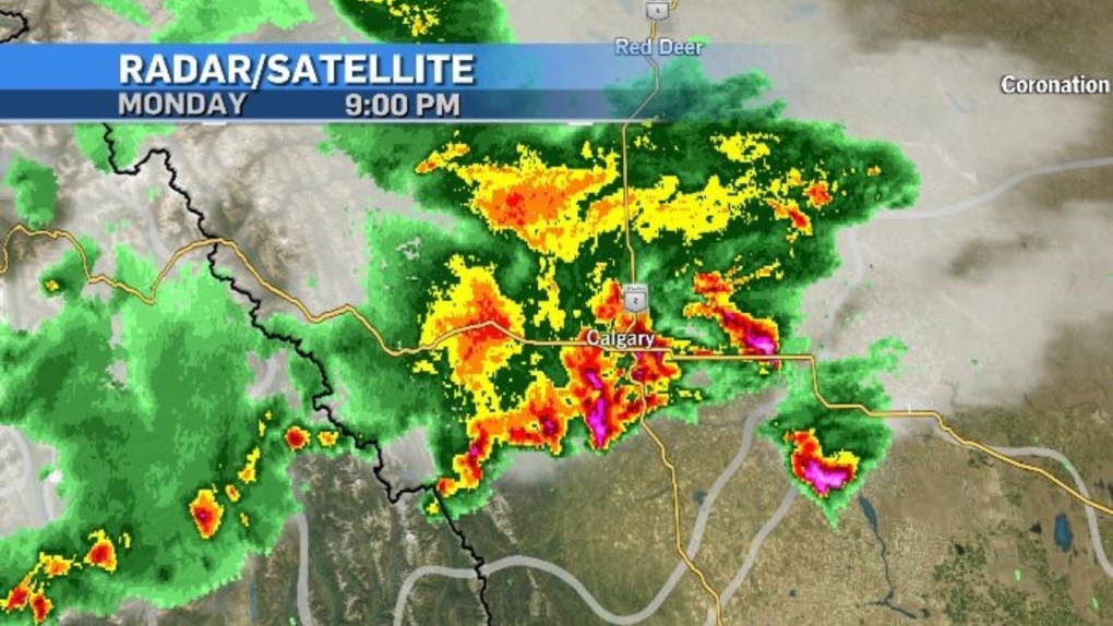 Radar from Monday, Aug. 5, 2024. (Note: the lightning layer has been removed to show the precipitation.) Instability will remain an issue for Tuesday, with scattered showers and thunderstorms forecast for southern Alberta – including in Calgary.
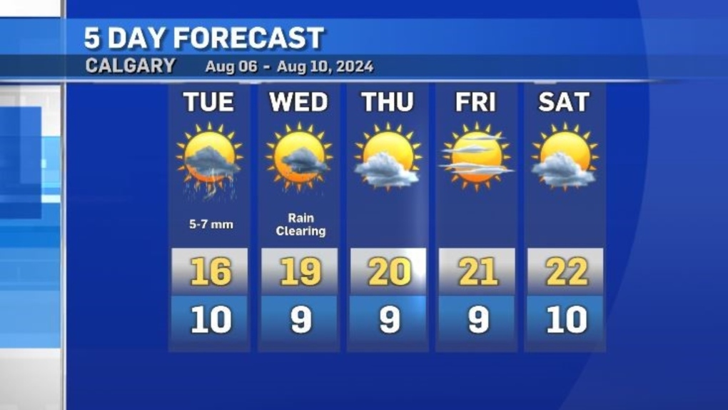
Rainfall totals will be much lower though, around five to seven millimetres for Calgary, with higher totals south of the city.
 As of 7:30 a.m. Tuesday, there were no storm-related watches or warnings for Alberta. However, there is the potential for large storms to develop along the southern border of the province on Tuesday and into Wednesday.
Daytime highs will remain below seasonal to start the week before gradually improving by the end of the week. However, even with the improvement, in Calgary the maximum temperatures will remain below the seasonal average of 24 C.
Shopping Trends
The Shopping Trends team is independent of the journalists at CTV News. We may earn a commission when you use our links to shop. Read about us.


Calgary Top Stories
-
 LIVE UPDATES
LIVE UPDATES Trudeau considering his options as leader after Freeland quits cabinet, sources say
-
-
-
-
-
-
-


CTVNews.ca Top Stories
LIVE UPDATES
LIVE UPDATES Trudeau considering his options as leader after Freeland quits cabinet, sources say
Chrystia Freeland, Canada's finance minister, said in an explosive letter published Monday morning that she will quit cabinet. Follow along for live updates.
BREAKING
BREAKING Feds deliver fall economic statement with $61.9B deficit for 2023-24, amid political turmoil
Amid the news that Chrystia Freeland has resigned from her cabinet position as finance minister, the Department of Finance on Monday unveiled the long-anticipated fall economic statement, which reports a deficit of $61.9-billion for 2023-24.
Finance Minister Chrystia Freeland quits cabinet, Trudeau taps LeBlanc to replace her
In a stunning move, Deputy Prime Minister and Finance Minister Chrystia Freeland announced Monday she's resigning from Justin Trudeau's cabinet, after the prime minister told her he no longer wanted her in the top economic post.
W5 Investigates
W5 Investigates Connecting the dots on a landlord scam: how clues revealed a prolific con artist at work
In part one of a three-part investigation, W5 correspondent Jon Woodward reveals how a convicted con artist bilked dozens of people in a landlord scam.
Teacher and teenage student killed in shooting at private Christian school in Wisconsin
A teenage student opened fire at a private Christian school Monday morning in Wisconsin, killing a teacher and another student in the final week before Christmas break. The shooter also died, police said.
Travel risk: Which countries does Canada recommend avoiding?
Canadians planning to travel abroad over the holidays should take precautionary steps to ensure they're not unintentionally putting themselves in harm's way.
Search continues for missing person in deadly B.C. landslide; local state of emergency declared
The village of Lions Bay has declared a local state of emergency as the search continues for a missing person, after a house was swept away in a landslide on Saturday.
Canada Post operations to resume on Tuesday, company says
Mail is set to begin moving again on Tuesday after a month-long strike by Canada Post employees comes to a close.
Jury delivers guilty verdicts for accused in Montreal-area triple homicide trial
The accused in a triple homicide trial south of Montreal has been found guilty.
Edmonton
-
LIVE UPDATES
LIVE UPDATES Trudeau considering his options as leader after Freeland quits cabinet, sources say
Chrystia Freeland, Canada's finance minister, said in an explosive letter published Monday morning that she will quit cabinet. Follow along for live updates.
-
Body found after suspicious fire south of Edmonton: RCMP
The body of a man was found after a house fire in Wetaskiwin over the weekend.
-
Transgender bill challenger dismayed by Smith's openness to notwithstanding clause
A lawyer challenging a new Alberta law affecting transgender youth says he is dismayed by Premier Danielle Smith's intention to use the notwithstanding clause if required.
Lethbridge
-

Province provides $150K to help fund programs for newcomer youth
Brooks, Alta., officials with the John Ware Youth Empowerment Program are hoping gto help even more young newcomers thanks to a $150,000 grant from the province.
-
Hitmen's Howe, Hurricanes' Yager make Team Canada world junior roster
Team Canada announced its 2025 IIHF World Junior Hockey Championship roster on Friday, including three players on southern Alberta WHL teams. Tanner Howe, of the Calgary Hitmen, Brayden Yager, of the Lethbridge Hurricanes, and Gavin McKenna, of the Medicine Hat Tigers, were among the 14 forwards that will be donning the maple leaf later this month.
-
Lethbridge's small businesses feeling the impact of continued Canada Post strike
It’s been four weeks since Canada Post employees went on strike, and small business owners in Lethbridge say the ongoing dispute makes it hard to keep shelves stocked.
Vancouver
-

Search continues for missing person in deadly B.C. landslide; local state of emergency declared
The village of Lions Bay has declared a local state of emergency as the search continues for a missing person, after a house was swept away in a landslide on Saturday.
-
B.C. Supreme Court dismisses 'natural person' lawsuit against CRA, TD Bank
A British Columbia man who describes himself as a "natural person" who is therefore exempt from paying income taxes has lost his attempt to sue his bank and the federal government for removing the funds from his account.
-
LIVE @ 6 PT
LIVE @ 6 PT How to watch CTV News at Six on Monday
With tonight’s CTV News at Six pre-empted, we are livestreaming a special online edition of our newscast anchored by Mi-Jung Lee.
Vancouver Island
-

B.C. Supreme Court dismisses 'natural person' lawsuit against CRA, TD Bank
A British Columbia man who describes himself as a "natural person" who is therefore exempt from paying income taxes has lost his attempt to sue his bank and the federal government for removing the funds from his account.
-
Suspect arrested after stabbing leaves man in critical condition on Vancouver Island
Mounties say a suspect is in police custody after a weekend stabbing left one man in hospital in critical condition on Vancouver Island.
-
Historic plane's final trip to U.S. interrupted by emergency landing near Victoria
A rare and historic water bomber that was on its final journey from British Columbia to a museum in Arizona was forced to make an emergency landing near Victoria due to mechanical issues.
Saskatoon
-

Sask. teachers begin binding arbitration hearings with province Monday
The Saskatchewan Teachers’ Federation (STF) begins binding arbitration with the province on Monday.
-
Kindersley RCMP searching for missing 89-year-old
Kindersley RCMP are asking the public to be on the lookout for an 89-year-old man who has gone missing.
-
Sask. AIMS system now forecasted to cost $250M, lessons learned report needed, auditor finds
The latest report by Saskatchewan's provincial auditor says the troubled Administrative Information Management System (AIMS) is now set to cost $250 million by the project's end.
Regina
-

Regina man faces negligence charge in connection to August dog attack
The Regina Police Service (RPS) have charged a suspect in connection to a dog attack that seriously injured a woman back in August.
-
Sask. AIMS system now forecasted to cost $250M, lessons learned report needed, auditor finds
The latest report by Saskatchewan's provincial auditor says the troubled Administrative Information Management System (AIMS) is now set to cost $250 million by the project's end.
-
Sask. teachers begin binding arbitration hearings with province Monday
The Saskatchewan Teachers’ Federation (STF) begins binding arbitration with the province on Monday.
Toronto
-
LIVE UPDATES
LIVE UPDATES Trudeau considering his options as leader after Freeland quits cabinet, sources say
Chrystia Freeland, Canada's finance minister, said in an explosive letter published Monday morning that she will quit cabinet. Follow along for live updates.
-
BREAKING
BREAKING Feds deliver fall economic statement with $61.9B deficit for 2023-24, amid political turmoil
Amid the news that Chrystia Freeland has resigned from her cabinet position as finance minister, the Department of Finance on Monday unveiled the long-anticipated fall economic statement, which reports a deficit of $61.9-billion for 2023-24.
-
Suspects at-large following jewelry store robbery, related hit-and-run at Toronto's Fairview Mall: police
Police are searching for four masked suspects after a smash-and-grab style robbery at a jewelry store in Toronto’s Fairview Mall.
Montreal
-

Jury delivers guilty verdicts for accused in Montreal-area triple homicide trial
The accused in a triple homicide trial south of Montreal has been found guilty.
-
Trial for slain Montreal artist moving forward despite accused lacking a lawyer
A Quebec Superior Court judge has decided to send a man accused of killing 24-year-old artist Romane Bonnier to trial in February even though the accused said he has not been able to find a lawyer more than three years after the alleged murder.
-
Quebec launches public registry to crack down on illegal short-term rentals
The Quebec government has launched the last component of Law 25 which aims to fight illegal short-term vacation rentals in the province.
Atlantic
-

Two dead, four in hospital including child after multi-vehicle crash in Moncton: first responders
The New Brunswick RCMP says two people have died and four others are injured following a multi-vehicle crash in Moncton Sunday night.
-
Backhoe used to tear the front off Newfoundland bank, four facing charges: RCMP
Four people in eastern Newfoundland are facing charges after a stolen backhoe was used to tear the front off the RBC bank in Holyrood.
-
Several tents destroyed by fire at Halifax-area homeless encampment
Fire destroyed several tents early in the morning at a Halifax-area encampment for homeless people.
Winnipeg
-

Manitoba deficit sits at $1.3 billion
Manitoba is projecting a higher than anticipated deficit for the year.
-
Weather causing multiple highway closures in Manitoba
Several highways in Manitoba, including one heading to the U.S. border, are closed due to winter weather.
-
Winnipeg man charged after security guard assaulted downtown
A Winnipeg man is in custody after he allegedly assaulted a security guard in downtown Winnipeg on Sunday.
Ottawa
-

Federal government reviving Kettle Island bridge idea with 'commitment' to new interprovincial crossing
The federal government's fall economic statement says the government is announcing its commitment to building a new bridge over the Ottawa River to connect Ottawa and Gatineau, reviving a controversial proposal that faced major public backlash more than 10 years ago.
-
LIVE UPDATES
LIVE UPDATES Trudeau considering his options as leader after Freeland quits cabinet, sources say
Chrystia Freeland, Canada's finance minister, said in an explosive letter published Monday morning that she will quit cabinet. Follow along for live updates.
-
Only money for Ottawa transit in fall economic statement is cash to study 2 km of Gatineau-Ottawa tram
The federal government's fall economic statement includes more than $30 million in funding for public transit in the Ottawa-Gatineau region, but none of it is earmarked for operations.
Northern Ontario
-
 BREAKING
BREAKING Feds deliver fall economic statement with $61.9B deficit for 2023-24, amid political turmoil
Amid the news that Chrystia Freeland has resigned from her cabinet position as finance minister, the Department of Finance on Monday unveiled the long-anticipated fall economic statement, which reports a deficit of $61.9-billion for 2023-24.
-
Two commercial truck drivers dead in Highway 11 crash
Two commercial truck drivers were killed and two passengers were taken to hospital after a crash on Highway 11 west of Hearst on Saturday, Ontario Provincial Police say.
-
Apartment fire in Elliot Lake, Ont., caused $6M in damage
A massive apartment fire in Elliot Lake last week caused $6 million in damage, fire officials said Monday.
Barrie
-

New details emerge in police-involved shooting at Innisfil, Ont. home
New details have emerged following a police-involved shooting at an Innisfil residence in August that left one young man dead and another facing serious charges.
-
Woman escapes house fire with baby in Alliston
A woman escaped her home with her baby after a fire broke out early Monday afternoon in Alliston.
-
Woman arrested after police cars damaged in criminal investigation in Barrie
Residents in Barrie took it to social media after spotting a heavy police presence in different parts of the city’s west end.
Kitchener
-

Finance Minister Chrystia Freeland quits cabinet, Trudeau taps LeBlanc to replace her
In a stunning move, Deputy Prime Minister and Finance Minister Chrystia Freeland announced Monday she's resigning from Justin Trudeau's cabinet, after the prime minister told her he no longer wanted her in the top economic post.
-
LIVE UPDATES
LIVE UPDATES Trudeau considering his options as leader after Freeland quits cabinet, sources say
Chrystia Freeland, Canada's finance minister, said in an explosive letter published Monday morning that she will quit cabinet. Follow along for live updates.
-
Police searching for missing 13-year-old last seen in Uptown Waterloo last week
Waterloo Regional Police are looking for a teen missing since late last week.
London
-

Police release images of vehicle involved in shooting outside London Hospital
London police have released images of the suspect vehicle involved in a shooting outside London Health Sciences Centre Victoria Campus.
-
Collision on Longwoods Road sends one person to hospital with serious injuries
According to police, one person has been taken to hospital with serious injuries as the result of a collision west of Lambeth.
-
'Two points of origin': Fire at boarded-up home in west London deemed suspicious
Crews were called to the scene in the area of Commissioners Road west and Rosecliffe Terrace around 1 p.m.
Windsor
-
LIVE UPDATES
LIVE UPDATES Trudeau considering his options as leader after Freeland quits cabinet, sources say
Chrystia Freeland, Canada's finance minister, said in an explosive letter published Monday morning that she will quit cabinet. Follow along for live updates.
-
$40,000 in cash and drugs seized in downtown Windsor
Windsor police have arrested three people after seizing over $40,000 in cash and drugs in downtown Windsor.
-
Drug trafficking suspects arrested for bail violations
Windsor police officers have arrested two suspects facing drug trafficking charges after police say they violated their bail conditions.


