Stormy start to the weekend but sun returns by Saturday
While Friday was sunny and warm throughout the day, a disruptive low-pressure system triggered a plethora of severe thunderstorm watches and warnings throughout Alberta for the overnight hours.
Calgary reached a high of 26 C for Friday, surpassing the seasonal high of 22 C for this time in August.
But the real big weather story for the city wasn't expected to happen until late Friday evening.
The low began to produce storms in Montana and Idaho Friday afternoon and continued to build in intensity and organization as it progressed north into Western Canada.
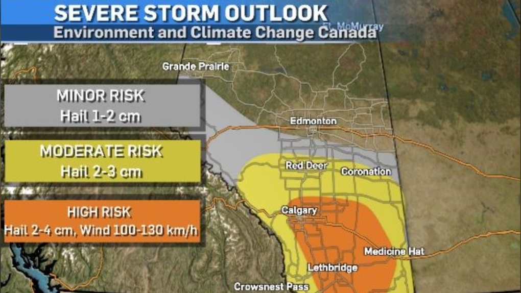
Environment and Climate Change Canada's severe storm outlook suggests the primary hazards for areas in the high-risk zone (in orange) could be hail stones two to four centimetres in diameter and strong winds exceeding 100 km/h.
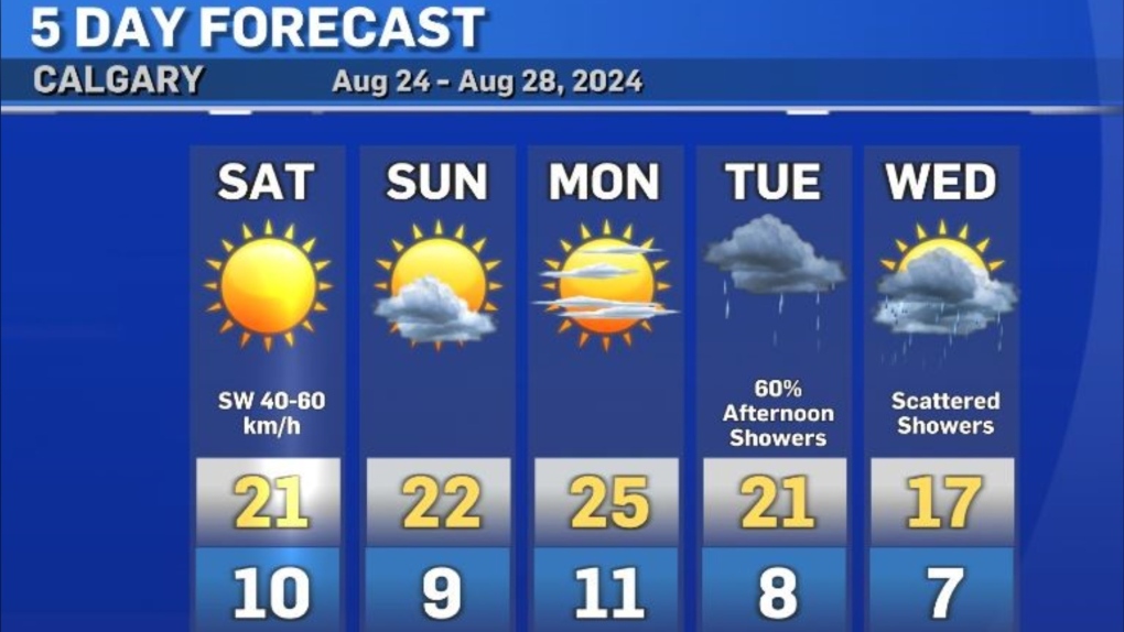
While the worst of the storm was expected to pass over Calgary around 10:30 to 11 p.m., nocturnal thunderstorms could be persistent throughout southern Alberta into the early morning hours of Saturday.
Once this system has passed, the rest of the weekend is looking very sunny and seasonal for southern Alberta, with Calgary getting up to a high of 21 tomorrow with strong southwest winds at 40 to 60 km/h.
There is a slight chance Calgary could experience some overnight showers/non-severe thunderstorms overnight Saturday into Sunday.
Shopping Trends
The Shopping Trends team is independent of the journalists at CTV News. We may earn a commission when you use our links to shop. Read about us.


CTVNews.ca Top Stories

Canada Post says workers to return Tuesday after labour board ruling
Operations at Canada Post will resume at 8 a.m. local time on Tuesday, Dec. 17, the company said, after the Canada Industrial Relations Board ordered a return to work.
W5 Investigates
W5 Investigates Connecting the dots on a landlord scam: how clues revealed a prolific con artist at work
In part one of a three-part investigation, W5 correspondent Jon Woodward reveals how a convicted con artist bilked dozens of people in a landlord scam.
Ottawa to unveil economic update detailing deficit, new border security package
The Liberal government in Ottawa is set to unveil its fall economic update today, its first spending package since Donald Trump won the November presidential election.
France rushes help to Mayotte, where hundreds or even thousands died in Cyclone Chido
France was rushing help by ship and military aircraft to its poor overseas territory of Mayotte in the Indian Ocean on Monday after the island was shattered by its worst storm in nearly a century.
Travel risk: Which countries does Canada recommend avoiding?
Canadians planning to travel abroad over the holidays should take precautionary steps to ensure they're not unintentionally putting themselves in harm's way.
Quebec threatens Montreal surgeon with sanctions, criminal charges for procedure she's done for over a decade
Quebec recently updated its list of approved surgeries and, despite endorsement from the Quebec Orthopedic Association, limb lengthening was not included.
Here's why critics believe hundreds of medically assisted deaths shouldn't have happened
Critics of medical assistance in dying (MAID) say there were more than 600 cases last year where they believe the program shouldn't have been an option at all.
1 dead, 1 unaccounted for after home 'displaced' by B.C. mudslide
A resident of a home impacted by a landslide near Lions Bay, B.C. on Saturday has been found dead, authorities confirmed.
Canada's premiers meet in Toronto to talk tariffs, trade and health care
Canada's premiers are meeting in Toronto today, and cross-border trade is topping the agenda, on the heels of a tariff threat from U.S. president-elect Donald Trump.
Edmonton
-

Premier willing to use the notwithstanding clause on Alberta trans health bill
Alberta Premier Danielle Smith says using the notwithstanding clause to shield her government's transgender health restrictions is on the table as a "last resort."
-
Slain security guard remembered in peace officer-style funeral service
Communities in Edmonton came together Sunday to honour a security guard killed on the job 10 days earlier.
-
Canada Post says workers to return Tuesday after labour board ruling
Operations at Canada Post will resume at 8 a.m. local time on Tuesday, Dec. 17, the company said, after the Canada Industrial Relations Board ordered a return to work.
Lethbridge
-

Province provides $150K to help fund programs for newcomer youth
Brooks, Alta., officials with the John Ware Youth Empowerment Program are hoping gto help even more young newcomers thanks to a $150,000 grant from the province.
-
Hitmen's Howe, Hurricanes' Yager make Team Canada world junior roster
Team Canada announced its 2025 IIHF World Junior Hockey Championship roster on Friday, including three players on southern Alberta WHL teams. Tanner Howe, of the Calgary Hitmen, Brayden Yager, of the Lethbridge Hurricanes, and Gavin McKenna, of the Medicine Hat Tigers, were among the 14 forwards that will be donning the maple leaf later this month.
-
Lethbridge's small businesses feeling the impact of continued Canada Post strike
It’s been four weeks since Canada Post employees went on strike, and small business owners in Lethbridge say the ongoing dispute makes it hard to keep shelves stocked.
Vancouver
-

1 dead, 1 unaccounted for after home 'displaced' by B.C. mudslide
A resident of a home impacted by a landslide near Lions Bay, B.C. on Saturday has been found dead, authorities confirmed.
-
Family, friends and fans gather at memorial for former B.C. premier John Horgan
Thousands of people who respected and loved former British Columbia premier John Horgan gathered for his memorial service in Colwood, B.C., Sunday.
-
Woman killed by falling tree during B.C. windstorm
A woman died after being hit by a falling tree in the driveway of her Metro Vancouver home when a powerful windstorm hit through B.C.’s South Coast Saturday.
Vancouver Island
-

Family, friends and fans gather at memorial for former B.C. premier John Horgan
Thousands of people who respected and loved former British Columbia premier John Horgan gathered for his memorial service in Colwood, B.C., Sunday.
-
Power restored for 99 per cent of customers after B.C. windstorm, utility says
The vast majority of the more than 300,000 BC Hydro customers who lost power during Saturday’s windstorm have the lights back on, the utility says.
-
1 dead, 1 unaccounted for after home 'displaced' by B.C. mudslide
A resident of a home impacted by a landslide near Lions Bay, B.C. on Saturday has been found dead, authorities confirmed.
Saskatoon
-

Have you seen this man? Kindersley RCMP searching for missing 89-year-old
Kindersley RCMP are asking the public to be on the lookout for an 89-year-old man who has gone missing.
-
Christmas film shot in Maple Creek showcased at Regina's IMAX
Regina's Kramer IMAX Theatre hosted a screening of a festive feature with a strong local connection Sunday. A Cowboy Christmas was shot in Maple Creek, which was a point of pride for those involved in the production.
-
Sask. Table Mountain opens for the season
With the amount of snow that Saskatchewan has seen over the past few weeks, ski hills are beginning to open their doors to the public for the season. At Table Mountain, just outside of the Battlefords, this last weekend marked their grand opening.
Regina
-

Christmas film shot in Maple Creek showcased at Regina's IMAX
Regina's Kramer IMAX Theatre hosted a screening of a festive feature with a strong local connection Sunday. A Cowboy Christmas was shot in Maple Creek, which was a point of pride for those involved in the production.
-
Southeast Saskatchewan hit with freezing rain warning
Environment and Climate Change Canada (ECCC) has issued freezing rain warnings Sunday which span most of Saskatchewan’s southeast corner.
-
Have you seen this man? Kindersley RCMP searching for missing 89-year-old
Kindersley RCMP are asking the public to be on the lookout for an 89-year-old man who has gone missing.
Toronto
-

Canada's premiers meet in Toronto to talk tariffs, trade and health care
Canada's premiers are meeting in Toronto today, and cross-border trade is topping the agenda, on the heels of a tariff threat from U.S. president-elect Donald Trump.
-
Canada Post says workers to return Tuesday after labour board ruling
Operations at Canada Post will resume at 8 a.m. local time on Tuesday, Dec. 17, the company said, after the Canada Industrial Relations Board ordered a return to work.
-
Group of Seven murals were considered destroyed after church fire. Here's how they are being brought back to life
Pieces of art and some murals from the St. Anne's Anglican Church have been retrieved and are now undergoing a restoration process by Toronto Art Restoration Inc. (TARI), based in the GTA.
Montreal
-

This Montreal man died of an aneurysm after waiting in the ER for six hours
A 39-year-old Montreal man died of an aneurysm after spending six hours in an emergency room before giving up and going home.
-
Quebec threatens Montreal surgeon with sanctions, criminal charges for procedure she's done for over a decade
Quebec recently updated its list of approved surgeries and, despite endorsement from the Quebec Orthopedic Association, limb lengthening was not included.
-
CAQ, Quebec City to make announcement about tramway
Francois Legault's government and Quebec City officials are slated to make an "important announcement" about the city's tramway project.
Atlantic
-
Canada Post says workers to return Tuesday after labour board ruling
Operations at Canada Post will resume at 8 a.m. local time on Tuesday, Dec. 17, the company said, after the Canada Industrial Relations Board ordered a return to work.
-
Housing Minister Sean Fraser set to leave Trudeau cabinet, as shuffle looms
Federal Housing Minister Sean Fraser is set to announce Monday he won't run in the next federal election, creating another cabinet vacancy in the Liberal government that's expected to be filled in a shuffle as early as this week.
-
N.S. man, 24, dies in single-vehicle crash in N.B.
The RCMP says a Nova Scotia man has died following a single-vehicle collision in New Brunswick.
Winnipeg
-
Canada Post says workers to return Tuesday after labour board ruling
Operations at Canada Post will resume at 8 a.m. local time on Tuesday, Dec. 17, the company said, after the Canada Industrial Relations Board ordered a return to work.
-
Winnipeg Syrians celebrate end of Assad regime with 'freedom' march
One week after the fall of the Assad regime in Syria, Winnipeggers came together to celebrate a new beginning for the country.
-
Winnipeg police chase with stolen car ends in arrest of break and enter suspect
The Winnipeg Police Service (WPS) arrested the suspect in a number of break and enters following a car chase with a stolen vehicle last week.
Ottawa
-
Canada Post says workers to return Tuesday after labour board ruling
Operations at Canada Post will resume at 8 a.m. local time on Tuesday, Dec. 17, the company said, after the Canada Industrial Relations Board ordered a return to work.
-
Police investigating body found near Rideau River in Ottawa
Ottawa police are investigating after a body was discovered near the Rideau River on Sunday afternoon.
-
Ottawa to unveil economic update detailing deficit, new border security package
The Liberal government in Ottawa is set to unveil its fall economic update today, its first spending package since Donald Trump won the November presidential election.
Northern Ontario
-

Two commercial truck drivers dead in Highway 11 crash
Two commercial truck drivers were killed and two passengers were taken to hospital after a crash on Highway 11 west of Hearst on Saturday, Ontario Provincial Police say.
-
Canada Post says workers to return Tuesday after labour board ruling
Operations at Canada Post will resume at 8 a.m. local time on Tuesday, Dec. 17, the company said, after the Canada Industrial Relations Board ordered a return to work.
-
Quebec threatens Montreal surgeon with sanctions, criminal charges for procedure she's done for over a decade
Quebec recently updated its list of approved surgeries and, despite endorsement from the Quebec Orthopedic Association, limb lengthening was not included.
Barrie
-

Police visit to elderly woman turns into act of community service
A routine wellness visit in Tay Township turned into an act of community service when Southern Georgian Bay OPP officers helped an 85-year-old woman.
-
Orillia's parking tickets add holiday cheer for little people
Parking ticket payouts send the gift of Christmas cheer.
-
Police cars damaged in ongoing criminal investigation in Barrie, police say
Residents in Barrie took it to social media after spotting a heavy police presence in different parts of the city’s west end.
Kitchener
-

Fog advisory in effect for Waterloo Region
On Monday, just after 5 a.m., Environment Canada issued a fog advisory for parts of southwestern Ontario, including Waterloo Region.
-
Canada Post says workers to return Tuesday after labour board ruling
Operations at Canada Post will resume at 8 a.m. local time on Tuesday, Dec. 17, the company said, after the Canada Industrial Relations Board ordered a return to work.
-
Travel risk: Which countries does Canada recommend avoiding?
Canadians planning to travel abroad over the holidays should take precautionary steps to ensure they're not unintentionally putting themselves in harm's way.
London
-

Fog advisories in effect, bus cancellations and delays
Heavy fog across the region this morning has led to a fog advisory stretching from Winsdor-Essex through London, Middlesex, Lambton and part of Huron and Perth Counties.
-
Canada Post says workers to return Tuesday after labour board ruling
Operations at Canada Post will resume at 8 a.m. local time on Tuesday, Dec. 17, the company said, after the Canada Industrial Relations Board ordered a return to work.
-
'We called a Code Silver': LHSC goes into lockdown after shooting outside emergency department
The emergency department (ED) doors at LHSC Victoria Campus were being repaired Saturday morning after a person fired a gun into the glass.
Windsor
-

Pedestrian dead following motor vehicle collision in Windsor
A pedestrian has died after a collision with a vehicle on Saturday.
-
Canada Post says workers to return Tuesday after labour board ruling
Operations at Canada Post will resume at 8 a.m. local time on Tuesday, Dec. 17, the company said, after the Canada Industrial Relations Board ordered a return to work.
-
Lions host first official event in Canada
Hundreds of Detroit Lions fans didn’t have to go stateside on Sunday to watch their team take the field. The team held a tailgate party at the Factory House as its first official event in Canada.


