Warm start to Monday with overnight temperatures 14 to 20 degrees above average
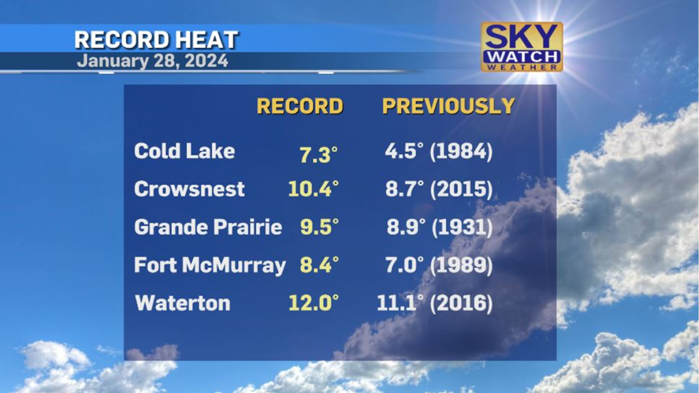
Fifteen communities in Alberta set new record high temperatures on Sunday, according to Environment and Climate Change Canada (ECCC).
The heat was well-distributed with new maximum temperatures recorded in Waterton, Crowsnest Area, Grande Prairie, Fort McMurray and Fort Chipewyan.
These records were exceeded by a range of 0.1 C to more than 2 C, with records dating back to 1883-1977.
Calgary did not break a record but did see a notable amount of melting over the weekend and started Monday with an unseasonably warm temperature.
 Several Alberta weather records were set on Jan. 28, 2024.
There are natural high and low points in a diurnal temperature cycle – largely related to incoming and outgoing radiation.
Throughout the day, the Earth’s surface will absorb heat from the sun and emit some of that energy back out (this outgoing radiation is the primary source for heating the air around us).
During the overnight hours, the only source of radiation is outgoing longwave radiation from the planet, which depletes as the morning approaches sunrise. This typically means the coldest point in the day occurs just before sunrise.
On Monday, the temperature at 7 a.m. at the airport in Calgary hit 6 C, which is 20 degrees warmer than the average overnight low.
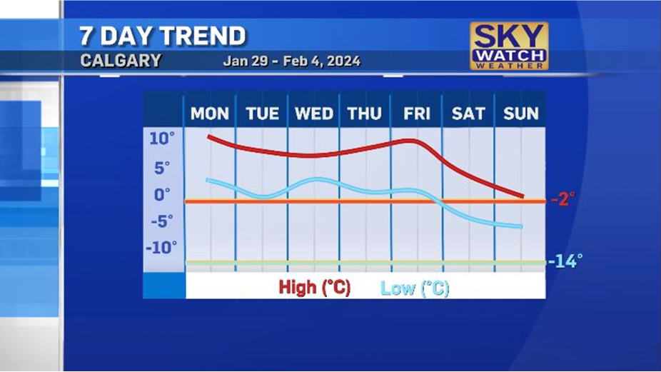
 Calgary's seven-day temperature trend for Jan. 29-Feb. 4, 2024.
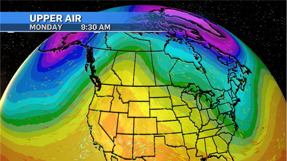
A dominant ridge of high pressure in the upper levels will continue to draw warmer air from the Pacific and move it across British Columbia, Alberta, Saskatchewan and into the southern portions of the Northwest Territories.
More records are expected to be broken, including in Edmonton, but once again Calgary is unlikely to make history.

Soaking rains are expected to impact portions of British Columbia early in the week, with some light and scattered rain possible across Alberta early Tuesday.
Depending on the atmospheric temperature profile and the temperature of the surface, some areas might end up with freezing rain.
Daytime highs this week will remain consistent, between nine to 11 degrees above average. Mostly clear skies will contribute to the melting, so roads, sidewalks and grassy areas will be messy.
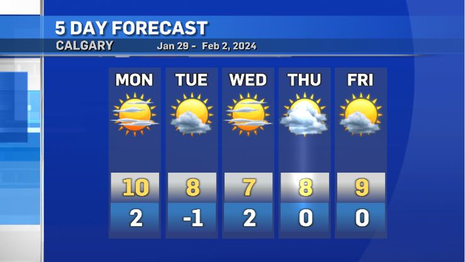
 Calgary five-day forecast for Jan. 29 - Feb. 2.
CTVNews.ca Top Stories

Canada Post says workers to return Tuesday after labour board ruling
Operations at Canada Post will resume at 8 a.m. local time on Tuesday, Dec. 17, the company said, after the Canada Industrial Relations Board ordered a return to work.
Housing Minister Sean Fraser set to leave Trudeau cabinet, as shuffle looms
Federal Housing Minister Sean Fraser is set to announce Monday he won't run in the next federal election, creating another cabinet vacancy in the Liberal government that's expected to be filled in a shuffle as early as this week.
Quebec threatens Montreal surgeon with sanctions, criminal charges for procedure she's done for over a decade
Quebec recently updated its list of approved surgeries and, despite endorsement from the Quebec Orthopedic Association, limb lengthening was not included.
W5 Investigates Connecting the dots on a landlord scam: how clues revealed a prolific con artist at work
In part one of a three-part investigation, W5 correspondent Jon Woodward reveals how a convicted con artist bilked dozens of people in a landlord scam.
Travel advisories: Here's what Canadians should know this holiday season
Canadians planning to travel abroad over the holidays should take precautionary steps to ensure they’re not unintentionally putting themselves in harm’s way.
Here's why critics believe hundreds of medically assisted deaths shouldn't have happened
Critics of medical assistance in dying (MAID) say there were more than 600 cases last year where they believe the program shouldn't have been an option at all.
'Immediately stop using': Health Canada warns balloon-blowing kits could cause 'hallucinations'
Health Canada released a consumer product advisory this week, warning that balloon-blowing kits that were available on Amazon.ca 'pose a chemical hazard.'
Police investigating body found near Rideau River in Ottawa
Ottawa police are investigating after a body was discovered near the Rideau River on Sunday afternoon.
British pubs are worried they'll run out of Guinness
At the Sheephaven Bay pub in London, tucked just behind Camden High Street, Guinness accounts for more than 50 per cent of draft beer sales.


