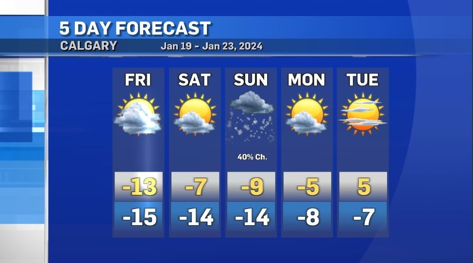
Calgary's daytime highs next week will be the warmest in three weeks
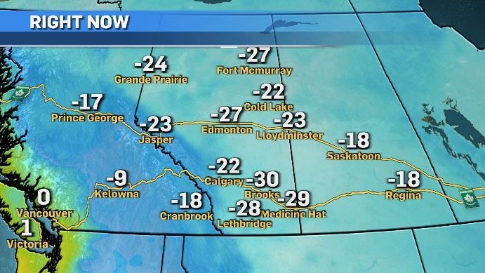
Most of Alberta started Friday under an extreme cold warning as Arctic air continues to funnel back into the Prairies from the polar vortex situated over the Labrador Sea.
Calgary was one of the warmest locations in southern Alberta Friday with a morning temperature of -22 C thanks in part to the adiabatic processes linked to the Rocky Mountains.
As of 8 a.m., warmer air was situated aloft with the Nakiska Ridgetop noted as the hot spot in Alberta at -6.8 C.
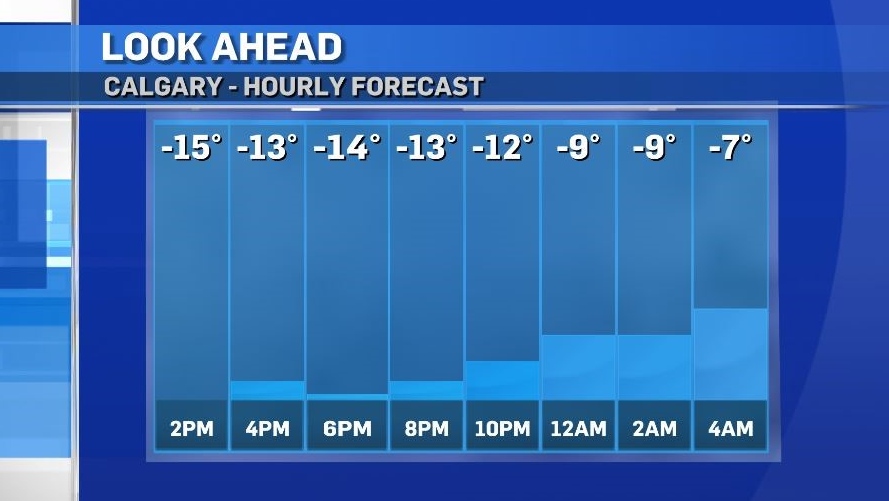
Temperatures in Calgary will gradually warm throughout the day on Friday with the warmest point occurring just before midnight.
Weather patterns are expected to reset by early next week as the polar vortex retreats north, and a large ridge of high pressure from the south creates zonal flow across the Prairies. This will result in the first above seasonal and positive temperature in nearly three weeks.
Overnight lows will play a key role in next weeks warmup, as they are expected to be above seasonal and fall within a narrow diurnal range (the difference between the daily maximum and daily minimum temperature).
In January, the average daytime high for Calgary is -3 C with a low of -15 C, creating a typical diurnal range of 12-degrees.
Over the next few days that diurnal range shrinks to a difference of just two to seven degrees and by the middle of next week the lows could be as warm as -8 C to -3 C.
With eight hours and 35 minutes between sunrise and sunset, a warmer overnight low temperature often assists in producing a warmer daytime high, as there is less energy needed from incoming solar radiation in order to achieve a peak temperature, so excess energy can lead to warmer highs.
Shopping Trends
The Shopping Trends team is independent of the journalists at CTV News. We may earn a commission when you use our links to shop. Read about us.


CTVNews.ca Top Stories

What is flagpoling? A new ban on the practice is starting to take effect
Immigration measures announced as part of Canada's border response to president-elect Donald Trump's 25 per cent tariff threat are starting to be implemented, beginning with a ban on what's known as 'flagpoling.'
Hong Kong police issue arrest warrants and bounties for six activists including two Canadians
Hong Kong police on Tuesday announced a fresh round of arrest warrants for six activists based overseas, with bounties set at $1 million Hong Kong dollars for information leading to their arrests.
Indigenous family faced discrimination in North Bay, Ont., when they were kicked off transit bus
Ontario's Human Rights Tribunal has awarded members of an Indigenous family in North Bay $15,000 each after it ruled they were victims of discrimination.
OPP and Ottawa firefighters help remove vehicle wedged into Highway 417 overpass
Ottawa firefighters and local Ontario Provincial Police officers were called to a bizarre scene Tuesday morning along Highway 417, where a driver managed to wedge his vehicle under an overpass.
Read Trudeau's Christmas message
Prime Minister Justin Trudeau issued his Christmas message on Tuesday. Here is his message in full.
Ontario First Nation challenging selection of underground nuclear waste site in court
A First Nation in northern Ontario is challenging the selection of a nearby region as the site of a deep geological repository that will hold Canada's nuclear waste, arguing in a court filing that it should have had a say in the matter as the site falls "squarely" within its territory.
Dismiss Trump taunts, expert says after 'churlish' social media posts about Canada
U.S. president-elect Donald Trump and those in his corner continue to send out strong messages about Canada.
Two arrested in Egypt after attempting to steal hundreds of ancient artifacts from the bottom of the sea
Egyptian authorities have arrested two men for attempting to steal hundreds of ancient artifacts from the bottom of the sea, the country’s interior ministry said in a Monday statement.
Quebec fugitive gunned down leaving gym in Mexican resort town
RCMP are confirming that a fugitive, Mathieu Belanger, wanted by Quebec provincial police has died in Mexico, in what local media are calling a murder.
Edmonton
-

Edmonton apartment building boarded up after evacuation order from the city
An Edmonton apartment building that was evacuated for safety reasons on Monday now sits boarded up.
-
1 charged after van stolen from Edmonton's Food Bank on Monday
One person has been arrested after a van was stolen from Edmonton's Food Bank on Monday.
-
Homelessness, rising property taxes major matters for Edmonton's mayor in 2024
Amarjeet Sohi looked back on the calendar year that's soon coming to a close with CTV News Edmonton, detailing recent challenges he and city council faced – typical year-end matters such as property taxes and finances – plus ongoing questions and efforts surrounding homelessness.
Lethbridge
-

Motorcyclist killed in Lethbridge crash
A 36-year-old man is dead after the motorcycle he was riding collided with an SUV in Lethbridge on Monday.
-
Lethbridge police arrest 3 people suspected of impaired driving
Hundreds of drivers were stopped during the third week of Lethbridge's Check Stop campaign, an initiative that police say led to dozens of tickets and three arrests.
-
'20 per cent increase': Interfaith Food Bank helps more than 900 households this holiday season
The last food bundles are heading out the door ahead of Christmas Day, as the Interfaith Food Bank nears the threshold of helping 1,000 households this holiday season.
Vancouver
-
Homicide victim identified as 36-year-old man from Langley, B.C.
Homicide investigators are identifying the victim of a suspected murder last year in Langley, B.C.
-
B.C. friends nab 'unbelievable' $1M lotto win just before Christmas
Two friends from B.C's lower mainland are feeling particularly merry this December, after a single lottery ticket purchased from a small kiosk landed them instant millionaire status.
-
Storms to continue rolling through B.C.'s South Coast over Christmas Day
The tempestuous weather that descended on southern B.C. Monday afternoon will linger for the next few days, with a storm forecast for Christmas Day.
Vancouver Island
-
Homicide victim identified as 36-year-old man from Langley, B.C.
Homicide investigators are identifying the victim of a suspected murder last year in Langley, B.C.
-
Year-end interview: B.C. Premier David Eby reflects on nail-biting 2024 election
It was a year that saw David Eby elected B.C. premier for the first time, and lead his party to government for a third consecutive term.
-
B.C. friends nab 'unbelievable' $1M lotto win just before Christmas
Two friends from B.C's lower mainland are feeling particularly merry this December, after a single lottery ticket purchased from a small kiosk landed them instant millionaire status.
Saskatoon
-

'People prop the doors open': Saskatoon resident concerned as people shelter in her stairwell
With the number of homeless people in Saskatoon at an unprecedented high, it’s no surprise people are looking for places to warm up.
-
Saskatoon-born comedian Brendan Flaherty returns to ask, 'what'd I miss?'
As a Saskatoon-born comedian pursuing a career in the Six, Brendan Flaherty says he often hears the same question from friends back home.
-
More drivers opt for personalized plates in Sask. — and behind every one there's a story
You may have noticed a few more vanity plates on Saskatchewan roads in recent years, and every one of them comes with a personal story.
Regina
-

Sask. RCMP still searching for man suspected of small-town break-ins spanning years
A man suspected of breaking into offices and small businesses across Saskatchewan over the past number of years has struck again – according to RCMP.
-
'A nice way to connect': Christmas card exchange between Sask. friends spans 60 years
What started out as a little holiday fun between two Regina friends has turned into a tradition that now spans six decades.
-
Dog lost in Saskatchewan during cross-country trip reunited with family
A family moving from Ontario to Alberta in November had a scare when their family dog got loose during a stop in Dafoe, Sask. and ran away.
Toronto
-

Trudeau could stay or go. Either way, Canadians should brace for a spring election
Canada appears to be barrelling toward a spring election now that the NDP is vowing to vote down the government early next year -- whether Prime Minister Justin Trudeau stays on or not.
-
Premiers urge Trudeau to extend deadline for charitable donations after postal strike
Canada’s premiers are calling on the federal government to extend the deadline for claiming charitable donations on tax returns through to the end of February.
-
Suspect charged after woman sexually assaulted by stranger at Keele Station: Toronto police
Toronto police have arrested a suspect in connection with an alleged sexual assault at a TTC subway station in the city’s west end.
Montreal
-

Snowfall means a white Christmas, but also traffic woes across southern Quebec roads
A heavy snowfall has guaranteed much of Quebec a white Christmas, but it has also sent cars skidding off the province's roads during the busy holiday travel period.
-
As governments try to solve housing crisis, modular homes emerge as potential solution
With all three levels of governments looking to find ways to build more housing and faster, one Quebec builder says it has the solution.
-
Quebec doing better job at retaining immigrants, Atlantic Canada still struggling
Immigrants are increasingly choosing to stay in Quebec, according to a new report from Statistics Canada, but the same isn't true in the Atlantic region, which continues to lose newcomers to the rest of the country.
Atlantic
-

Two deaths in Truro ruled homicides: RCMP
Police in Nova Scotia are investigating after two deaths in Truro, N.S., over the weekend have been ruled homicides.
-
Snow forecast through Christmas Eve for parts of the Maritimes
Parts of the Maritimes that were hit by a weekend snowstorm are in for more of the white stuff this Christmas Eve.
-
'Can I taste it?': Rare $55,000 bottle of spirits for sale in Moncton, N.B.
A rare bottle of Scotch whisky is for sale in downtown Moncton, N.B., with a price tag reading $55,000.
Winnipeg
-

One person dead, another injured following Monday night house fire
One person has died and another is in unstable condition following a house fire Monday evening.
-
Winnipeg police investigating string of packages being stolen
The Winnipeg Police Service is investigating a string of package thefts in the Transcona area.
-
Colleen Bready's forecast: How conditions are shaping up for Santa's flight
Mild conditions across Manitoba and northwestern Ontario should make for a smooth flight for Santa and his reindeer tonight. They will just have to watch out for fog patches overnight across the south.
Ottawa
-

OPP and Ottawa firefighters help remove vehicle wedged into Highway 417 overpass
Ottawa firefighters and local Ontario Provincial Police officers were called to a bizarre scene Tuesday morning along Highway 417, where a driver managed to wedge his vehicle under an overpass.
-
Ottawa driver gets double licence suspension after allegedly going 3 times the speed limit
Ottawa police say a 54-year-old man is facing several charges after allegedly going more than three times the speed limit this weekend.
-
Last minute shoppers in Ottawa wrap up Christmas wish lists
Residents in the capital spent the day at Tanger Outlets in Kanata, looking to put the finishing touches on their holiday shopping, while others were just getting started.
Northern Ontario
-

Indigenous family faced discrimination in North Bay, Ont., when they were kicked off transit bus
Ontario's Human Rights Tribunal has awarded members of an Indigenous family in North Bay $15,000 each after it ruled they were victims of discrimination.
-
Norad crew waiting for Santa to fly over Canada as annual holiday track underway
Departing from the North Pole while we were all sleeping, Santa Claus' journey around the world bringing presents and Christmas cheer for all of the good boys and girls who believe is underway.
-
Dismiss Trump taunts, expert says after 'churlish' social media posts about Canada
U.S. president-elect Donald Trump and those in his corner continue to send out strong messages about Canada.
Barrie
-

Live trackers await Santa Claus and his reindeer crew, special track underway in Simcoe County
The spirit of Christmas is in the air as Santa Claus begins his lasting journey to deliver presents to children around the region.
-
Owen Sound man claims $1M prize
Owen Sound man finally claims winning ticket days before Christmas.
-
No parking on Barrie streets on Christmas Eve
Barrie crews will work tonight to clear the snow from its streets.
Kitchener
-

Why holiday shopping may feel a little different this year
At around 11 a.m. Tuesday at Kitchener’s Fairview Park Mall, there were plenty of parking spots available. It’s a sign that maybe this year, the rush for last minute gifts is no more.
-
What’s open and what’s closed over the holidays
A detailed guide to what’s open and closed between Dec. 24 and New Year's Day.
-
Police investigating after vandalization of Pride crosswalk in Waterloo
Waterloo Regional Police are investigating after a Pride crosswalk was vandalized in Waterloo on Sunday.
London
-

Palace Theatre boarded up over the holidays due to recent damage
A break in, theft, and continued property damage has led to the boarding up of the Palace Theatre over the Christmas holidays.
-
London fire responds to Wellington Road collision, contains fuel leak
London Fire Department was on the scene of a two vehicle collision involving a delivery truck on Tuesday morning.
-
'It’s a surprise': Shoebox Project gives women impacted by homelessness a Christmas gift
For many of the women attending My Sister’s Place (MSP) in London, Ont. the holidays are a difficult time.
Windsor
-
WECHU warning of positive avian influenza cases
The Windsor-Essex County Health Unit (WECHU) is working to alert the public of the dangers of avian influenza after waterfowl in the area tested positive.
-
Been to Detroit lately? Keep an eye out for these scam parking invoices
The City of Detroit has issued a warning to motorists that scam texts are circulating asking for payment for unpaid parking invoices from the city.
-
Chatham police aware of physical incident between two children going viral on social media
The Chatham-Kent Police Service said it is aware of a video going viral on social media, showing a physical incident between two children in the area.


