Cool and wet weather for the long weekend

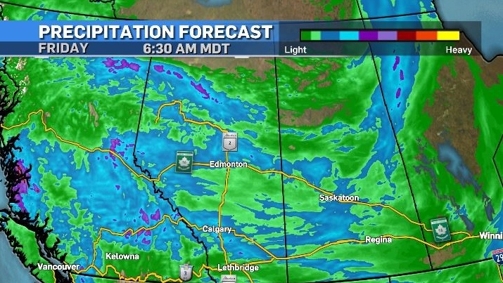
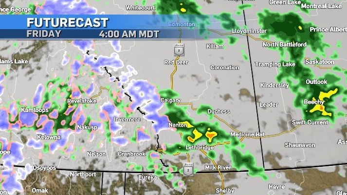
Wednesday will be the warmest day for at least a week. Daytime highs for the May long weekend will be underwhelming and scattered showers and thunderstorms are likely every day until at least Sunday
Instability throughout central and southern Alberta Wednesday will produce showers and non-severe thunderstorms that will continue overnight.
Rain will be more persistent on Thursday and Friday but it will also impact portions of northern Alberta, which should will prove helpful than not.
The fire risk is still a major concern for areas currently dealing with wildfires, including near Grande Prairie and Fort McMurray – where both of Alberta’s wildfires that are rated as “out of control” are burning.
But, at this point, rain would need to be soaking and intense before it could dramatically alter the situation.

As of 7:30 a.m. Wednesday, air quality advisories remain in effect for northern B.C., Alberta, Saskatchewan and Manitoba with zonal flow pulling that smoke from west to east.
There will be a push from the north later Wednesday bringing stronger winds and colder air to central and southern Alberta, but this will be accompanied by rain, so air quality is unlikely to deteriorate significantly as the rain will pull any incoming particulate to the surface.

Overnight lows will be close to freezing in many communities over the weekend and mixed precipitation is possible overnight west of Calgary in higher elevations.

Within the city the urban heat island effect should keep temperatures just above freezing in most communities, but with fresh moisture in the ground this line will be close. Evaporation typically occurs in the early mornings just before sunrise – and with evaporation being a cooling process – some communities may dip below 0 C.
Monday will likely be the warmest day of the long weekend – with more sunshine expected and a forecast high of 13 C.

CTVNews.ca Top Stories

Aviation experts say Russia's air defence fire likely caused Azerbaijan plane crash as nation mourns
Aviation experts said Thursday that Russian air defence fire was likely responsible for the Azerbaijani plane crash the day before that killed 38 people and left all 29 survivors injured.
Police identify victim of Christmas Day homicide in Hintonburg, charge suspect
The Ottawa Police Service says the victim who had been killed on Christmas Day in Hintonburg has been identified.
Teen actor Hudson Meek, who appeared in 'Baby Driver,' dies after falling from moving vehicle
Hudson Meek, the 16-year-old actor who appeared in 'Baby Driver,' died last week after falling from a moving vehicle in Vestavia Hills, Alabama, according to CNN affiliate WVTM.
Boxing Day in Canada: Small retailers fear big shopping day won't make up for tough year
It’s one of the busiest shopping days of the year: Boxing Day sees thousands of people head to malls and big box stores to find great deals. But it's not so simple for smaller shops.
Raised in Sask. after his family fled Hungary, this man spent decades spying on communists for the RCMP
As a Communist Party member in Calgary in the early 1940s, Frank Hadesbeck performed clerical work at the party office, printed leaflets and sold books.
Sinkhole prompts lane closures on Interstate 80 in New Jersey
A sinkhole that opened up Thursday along Interstate 80 in northern New Jersey forced authorities to close the heavily travelled highway's eastbound lanes.
Cat food that caused bird-flu death of Oregon pet was distributed in B.C.: officials
Pet food contaminated with bird flu – which killed a house cat in Oregon – was distributed and sold in British Columbia, according to officials south of the border.
Police in New Brunswick investigating Christmas Eve sudden death
An unconscious individual was found in the 600-block area of Lancaster Avenue early Christmas Eve morning, and was later pronounced dead at a hospital.
Pizza deliverer in Florida charged with stabbing pregnant woman at motel after tip dispute
A pizza deliverer in central Florida has been charged with pushing her way into a motel room with an accomplice and stabbing a pregnant woman after a dispute over a tip, authorities said.


