Flames game day forecast: You may want to bring a red umbrella
UPDATE: The way this system is developing, Calgary's not out of the woods on rainshowers yet.
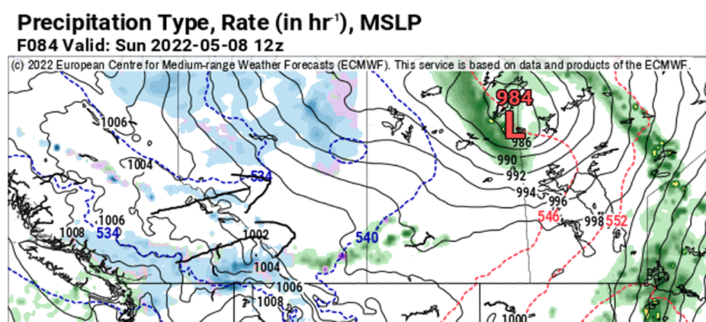
Firstly, there are two images below; the first is what's expected Friday morning, but with that system popping free of the foothills, Calgary gets a chance of showers this evening; light stuff, as we cool off, somewhat. If you're planning on taking in the Flames game somewhere out-of-doors, that's worth considering. Yesterday's modeling had this setup further north; while a chance for 1-3 mm is in the immediate forecast, it's spread out over six plus hours.
For the weekend, there's still a wide spread among forecast models, but I'm comfortable suggesting over 10 millimetres will fall between Saturday afternoon and midnight Sunday. Spotty showers still exist beyond then, as well. Most of this is pulled free of the foothills.
We may also run into periods with mixed precipitation. Low temperature trends have started improving, however, so that chance is presently quite remote.
It's time for the Thursday edition of "How Warm Today, And How Much Rain This Weekend?" The answers to these questions are 22 C, and… less than previously predicted.
Let's break it all down.
A number of forecast models pin today squarely on a high near 20 C, but we're still coping with warm wind. Today it rises from the south instead of yesterday's westerlies, which popped sections of the city to 22-23 C. Still, that's a contributing factor to the high, though it will involve gusts to at least 40 km/h, with a chance we crack 50.
Ditto Friday, but with a directional shift back to westerlies.
So what's changing, again, for precipitation? Here's the early Friday look:

So that low bursts onto the scene tomorrow morning. It'll help create westerlies for us. There's a wildly small chance of showers late Friday from it. But that’s not the low we’re interested in; this is:

The expectation is that this one (which would arrive on the Saskatchewan-Manitoba boundary Sunday morning) would be grabbing moisture off the foothills and throwing it at us. This one was projected this week to form in Montana before swinging to the north-northeast. The previous track took longer – it's moving a lot more rapidly now, which limits the impact in southern Alberta. It's a small change, but it's further proof that forecast models don’t like mountains, much.
The Saturday forecast is not completely dried out, but as we close in and models verify, we're down from "rain" to "chance of showers." Not great.
Sunday still runs a shot, and so does Monday. Now, we're peaking at 15 millimetres, but likely closer to eight mm.
YOUR FIVE-DAY CALGARY FORECAST
Tonight
- Evening: shower risk, some cloud, low 7 C
Friday
- Partly cloudy
- Daytime high: 17 C
- Evening: some cloud, low 6 C
Saturday
- Mainly sunny, chance of p.m. showers
- Daytime high: 13 C
- Evening: chance of showers, low 2 C
Sunday
- Showers
- Daytime high: 10 C
- Evening: mainly cloudy, chance of showers, low 0 C
Monday
- Mainly cloudy, scattered showers
- Daytime high: 10 C
- Evening: clearing, low -1 C
Tuesday
- Partly cloudy
- Daytime high: 12 C
- Evening: clearing, low -1 C
Today's pictures are all the awesome chinook arch honourable mentions that came through on Twitter:
Whether it's wildlife, weather or pets – submit your photos here, email me here, or tweet them over.
CTVNews.ca Top Stories

What is flagpoling? A new ban on the practice is starting to take effect
Immigration measures announced as part of Canada's border response to president-elect Donald Trump's 25 per cent tariff threat are starting to be implemented, beginning with a ban on what's known as 'flagpoling.'
Hong Kong police issue arrest warrants and bounties for six activists including two Canadians
Hong Kong police on Tuesday announced a fresh round of arrest warrants for six activists based overseas, with bounties set at $1 million Hong Kong dollars for information leading to their arrests.
Indigenous family faced discrimination in North Bay, Ont., when they were kicked off transit bus
Ontario's Human Rights Tribunal has awarded members of an Indigenous family in North Bay $15,000 each after it ruled they were victims of discrimination.
Heavy travel day starts with brief grounding of all American Airlines flights
American Airlines briefly grounded flights nationwide Tuesday because of a technical problem just as the Christmas travel season kicked into overdrive and winter weather threatened more potential problems for those planning to fly or drive.
OPP and Ottawa firefighters help remove vehicle wedged into Highway 417 overpass
Ottawa firefighters and local Ontario Provincial Police officers were called to a bizarre scene Tuesday morning along Highway 417, where a driver managed to wedge his vehicle under an overpass.
On Christmas Eve, Pope Francis appeals for courage to better the world
Pope Francis said the story of Jesus' birth as a poor carpenter's son should instill hope that all people can make an impact on the world, as the pontiff on Tuesday led the world's Roman Catholics into Christmas.
Read Trudeau's Christmas message
Prime Minister Justin Trudeau issued his Christmas message on Tuesday. Here is his message in full.
Ontario First Nation challenging selection of underground nuclear waste site in court
A First Nation in northern Ontario is challenging the selection of a nearby region as the site of a deep geological repository that will hold Canada's nuclear waste, arguing in a court filing that it should have had a say in the matter as the site falls "squarely" within its territory.
Dismiss Trump taunts, expert says after 'churlish' social media posts about Canada
U.S. president-elect Donald Trump and those in his corner continue to send out strong messages about Canada.


