Heavy, wet snow continues until the weekend, creating travel and traction issues
As expected, there was a rapid deterioration in weather conditions with persistent precipitation in central and southern Alberta.
Snow started in the Calgary area Tuesday evening and will continue for days.
This long-duration snowfall event prompted Environment and Climate Change Canada (ECCC) to issue and expand snowfall warnings on Tuesday as “10 to 30 cm of snow is expected by Friday morning across southern Alberta.”
The national weather agency explains most areas under the warning will receive between 10 to 15 centimetres of snow, but some regions will see totals much higher than that.
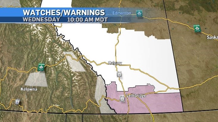 Weather advisories from ECCC on Tuesday, March 19, 2024 include a snowfall warning (white), a special weather statement (pink) and air quality advisories (grey).
Some communities in the Calgary area started Tuesday with slushy and icy conditions as well as snow.
Warmer temperatures closer to the surface, combined with an atmospheric profile containing a large region of dendritic growth (snow growth) allowed precipitation to partially melt before landing on a warmer surface.
Due to a robust source of moisture and the enhancement of upsloping, many roads and highways early in the day were slippery due to a layer of ice under the snow.
- READ MORE: Calgary under snowfall warning, drivers warned to take precautions
Travel is expected to remain challenging Wednesday, with ECCC advising “Surfaces such as highways, roads, walkways and parking lots may become difficult to navigate due to accumulating snow.”
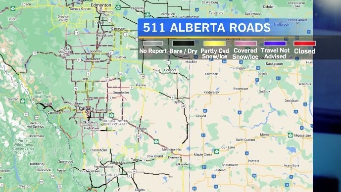
As of 10:30 a.m. Wednesday, 511 Alberta was displaying icy and snow-covered conditions across central and southern Alberta, as well as reporting multiple incidents.
Sidewalks, parking lots and pathways are also likely to offer poor traction and snow removal has the potential to be dangerous. Spring snow is often more heavy and wet, and shovelling that type of snow can be more taxing on the heart.
Colder air will continue to funnel into Alberta over the next two days with the base of the trough situated near the southern border of the western Prairies.
The counter-clockwise circulation associated with that low is creating isentropic lift against the Rockies or more simply – the system is stalling out and producing persistent precipitation on the eastern side of the mountains.

Easterly winds at the surface will hover around 15 to 20 kilometres for most of the day Wednesday, making temperatures feel colder than they are, but also affecting visibility where there is fresh and/or falling snow.
This setup is expected to remain in place until at least Friday – but it will take a little more time before the temperature improves.
Daytime highs in Calgary over the weekend are expected to match the average overnight low of -8 C, and that lack of heat and cloud cover will limit the amount of melting in the short term.

For the latest weather advisories from ECCC click here., and click here for the current Alberta road condition from 511 Alberta. Drive BC highway conditions can be found here.
Shopping Trends
The Shopping Trends team is independent of the journalists at CTV News. We may earn a commission when you use our links to shop. Read about us.


CTVNews.ca Top Stories

Aviation experts say Russia's air defence fire likely caused Azerbaijan plane crash as nation mourns
Aviation experts said Thursday that Russian air defence fire was likely responsible for the Azerbaijani plane crash the day before that killed 38 people and left all 29 survivors injured.
Police identify victim of Christmas Day homicide in Hintonburg, charge suspect
The Ottawa Police Service says the victim who had been killed on Christmas Day in Hintonburg has been identified.
Teen actor Hudson Meek, who appeared in 'Baby Driver,' dies after falling from moving vehicle
Hudson Meek, the 16-year-old actor who appeared in 'Baby Driver,' died last week after falling from a moving vehicle in Vestavia Hills, Alabama, according to CNN affiliate WVTM.
Pizza deliverer in Florida charged with stabbing pregnant woman at motel after tip dispute
A pizza deliverer in central Florida has been charged with pushing her way into a motel room with an accomplice and stabbing a pregnant woman after a dispute over a tip, authorities said.
Raised in Sask. after his family fled Hungary, this man spent decades spying on communists for the RCMP
As a Communist Party member in Calgary in the early 1940s, Frank Hadesbeck performed clerical work at the party office, printed leaflets and sold books.
Cat food that caused bird-flu death of Oregon pet was distributed in B.C.: officials
Pet food contaminated with bird flu – which killed a house cat in Oregon – was distributed and sold in British Columbia, according to officials south of the border.
Unwanted gift card in your stocking? Don't let it go to waste
Gift cards can be a quick and easy present for those who don't know what to buy and offer the recipient a chance to pick out something nice for themselves, but sometimes they can still miss the mark.
India alleges widespread trafficking of international students through Canada to U.S.
Indian law enforcement agencies say they are investigating alleged links between dozens of colleges in Canada and two 'entities' in Mumbai accused of illegally ferrying students across the Canada-United States border.
2 minors, 2 adults critically injured in south Calgary crash; incident was preceded by a robbery
Multiple people were rushed to hospital, including two minors, in the aftermath of a serious vehicle collision on Thursday morning.
Edmonton
-

These are the scams that affected Albertans the most in 2024
CTV News Edmonton looks at the scams that affected Albertans the most in 2024, and how you can protect yourself.
-
Alberta premier hopes for health reform payoff in 2025, regrets deferring tax cut
"It may have been better for Albertans if we'd implemented and then found a way to be able to pay for it."
-
Aviation experts say Russia's air defence fire likely caused Azerbaijan plane crash as nation mourns
Aviation experts said Thursday that Russian air defence fire was likely responsible for the Azerbaijani plane crash the day before that killed 38 people and left all 29 survivors injured.
Lethbridge
-

Lake Louise ice climber takes a scary fall, then carries on climbing ice
The sport of ice climbing is becoming more and more popular, but one man is lucky to be alive after a serious fall in Alberta’s back country.
-
Safety tips for holiday home cooks: Lethbridge Fire and Emergency Services
If you’re planning to cook over the holidays, Lethbridge Fire and Emergency Services is reminding everyone to do it safely.
-
Here’s which bins your Christmas wrapping, ribbons and leftovers should go into
With piles of presents unwrapped Wednesday, Environment Lethbridge is reminding everyone to dispose of all that waste properly.
Vancouver
-

1 airlifted, highway closed after crash in Mission
Lougheed Highway is closed in Mission, B.C., after a car crash Thursday morning that seriously injured at least one person, Mounties say.
-
These were the most-borrowed books from Vancouver libraries in 2024
What have Vancouverites been reading in 2024? The Vancouver Public Library has released its lineup of the books that kept flying off the shelf this year, which can serve as inspiration for bookworms’ 2025 reading lists.
-
Cat food that caused bird-flu death of Oregon pet was distributed in B.C.: officials
Pet food contaminated with bird flu – which killed a house cat in Oregon – was distributed and sold in British Columbia, according to officials south of the border.
Vancouver Island
-

Multiple sailing waits for BC Ferries after further cancellations
BC Ferries cancelled multiple early morning sailings between the Lower Mainland and Vancouver Island Thursday morning, as weather warnings due to wind and heavy rain remain in effect.
-
Avalanche risk 'extreme' for parts of B.C. coast
The avalanche danger rating for mountains on B.C.’s South Coast was “extreme” on Boxing Day, according to Canada’s non-profit forecaster.
-
Cat food that caused bird-flu death of Oregon pet was distributed in B.C.: officials
Pet food contaminated with bird flu – which killed a house cat in Oregon – was distributed and sold in British Columbia, according to officials south of the border.
Saskatoon
-
Raised in Sask. after his family fled Hungary, this man spent decades spying on communists for the RCMP
As a Communist Party member in Calgary in the early 1940s, Frank Hadesbeck performed clerical work at the party office, printed leaflets and sold books.
-
IN PICTURES: CTV Saskatoon viewers send us their holiday photos
A living gallery of viewer-submitted photos from the holiday season. Share your pictures with us at SaskatoonNews@bellmedia.ca
-
Sask. highway closed following serious collision
The Saskatchewan RCMP are investigating a serious collision on Highway 7, approximately 15 kilometres west of Rosetown.
Regina
-

Yorkton RCMP seek tips to locate unlawfully-at-large inmate
Yorkton RCMP is seeking tips from the public to locate an inmate after staff noticed he was not present at the Whitespruce Provincial Training Centre.
-
Pedestrian collision sends man to hospital with life-threatening injuries
One man has been sent to hospital with life-threatening injuries after he was struck by a vehicle in the early hours of Wednesday in Regina.
-
Raised in Sask. after his family fled Hungary, this man spent decades spying on communists for the RCMP
As a Communist Party member in Calgary in the early 1940s, Frank Hadesbeck performed clerical work at the party office, printed leaflets and sold books.
Toronto
-

OPP shut down Hwy. 401 off-ramp clogged with Boxing Day deal-hunters
A Highway 401 off-ramp west of Toronto became so clogged up with Boxing Day deal-hunters Thursday that police had to shut it down.
-
Pedestrian seriously injured after being struck by driver of vehicle in North York
A pedestrian has been seriously injured after being hit by the driver of a vehicle in North York late Thursday afternoon.
-
Man wanted for 2 unprovoked incidents in downtown Toronto on Christmas Eve
Toronto police are searching for a suspect who allegedly choked a female in downtown Toronto then threatened an employee at a business with a hammer.
Montreal
-
 WEATHER
WEATHER Smog warning in effect in Montreal, Laval
Residents of Montreal, Laval and other regions are advised that a smog warning is in effect.
-
Quebec teenager gives his Make-A-Wish donation to his community
When the Make-A-Wish Foundation offered Gerry McAdam anything he wanted he didn't know what to do. The 16-year-old from Hemmingford, Quebec is battling sarcoma, a rare form of tissue cancer.
-
A very different Boxing Day from previous years
In a markedly different economic context than last year, with fiercer and more unfair international competition than ever and less than two weeks after the end of the Canada Post strike, this year’s Boxing Day sales are set to be different from those in previous years, says the Quebec Retail Council (CQCD).
Atlantic
-

Christmas Day fire causes heavy damage to building in Saint John, N.B.
A fire caused a power outage for around 900 residents of Saint John, N.B., Wednesday afternoon.
-
Civil War sword with N.B. ties now on display at Loyalist House
The blade of Dr. John F. Stevenson, who was born in Saint Andrews, N.B., is now part of the New Brunswick Historical Society’s collection after being purchased from a collector for $6,200 dollars.
-
Temporary overnight parking ban for Saint John, N.B.
Saint John, N.B., has declared an overnight parking ban for the South/Central Peninsula beginning 11 p.m. Thursday evening through 7 a.m. Friday morning.
Winnipeg
-

16-year-old boy found with machete: Police
A 16-year-old boy is in custody after police said they found him with a machete.
-
Boxing Day in Canada: Small retailers fear big shopping day won't make up for tough year
It’s one of the busiest shopping days of the year: Boxing Day sees thousands of people head to malls and big box stores to find great deals. But it's not so simple for smaller shops.
-
Have you seen Davis? Winnipeg police search for missing man
Winnipeg police are asking the public to help find a man who went missing last week.
Ottawa
-

Police identify victim of Christmas Day homicide in Hintonburg, charge suspect
The Ottawa Police Service says the victim who had been killed on Christmas Day in Hintonburg has been identified.
-
World Junior Championship to create a buzz in Ottawa this Boxing Day
A Canadian hockey holiday tradition returns to the capital this Boxing Day, as the 2025 World Junior Championship is set to create a buzz in the city.
-
What's open and closed in Ottawa over the holidays
CTVNewsOttawa.ca takes a look at what's open and closed over the Christmas and New Year's holidays this year.
Northern Ontario
-

Drug trade fuelling increase in gun crime in Timmins, police say
Police in Timmins say gun crime is increasing in the city because of the drug trade, especially involving opioids.
-
Freezing drizzle advisory in effect for Greater Sudbury
Environment Canada issued a freezing drizzle advisory Thursday for areas in and around Greater Sudbury.
-
Average home sale prices in the Sault set new record last month
Homes sales edged upward in many markets in northern Ontario last month, including Sault Ste. Marie, where average sale prices set a new record.
Barrie
-
Teen allegedly attempting to avoid R.I.D.E. program leads to police chase, arrest
A teenage driver is facing numerous charges after reportedly attempting to avoid a R.I.D.E. program and flee from police in Essa Township late Christmas night.
-
Christmas Day break and enter under investigation
Police are searching for those who were involved in an alleged break and enter at a Gravenhurst business on Christmas Day.
-
Woman charged after driving in oncoming traffic: OPP
A 78-year-old female driver is facing charges after reportedly driving into oncoming traffic in Wasaga Beach on Christmas Eve.
Kitchener
-

Fire rips through former Peter Hay Knife Company building in Cambridge
Emergency responders were called to a fire in Cambridge on Thursday as flames ripped through the building that formerly belonged to the Peter Hay Knife Company.
-
Sawed-off shotgun and three knives seized during Cambridge arrest
Two people from Thunder Bay are facing drug trafficking and weapons charges after they were arrested in Cambridge.
-
Baden-born player, Guelph Storm forward and former Kitchener Ranger prepare to hit the ice at World Juniors
Waterloo Region and Guelph will be well represented as the International Ice Hockey Federation World Juniors gets underway.
London
-

Palace Theatre boarded up over the holidays due to recent damage
A break in, theft, and continued property damage has led to the boarding up of the Palace Theatre over the Christmas holidays.
-
Knights stars ready to help Canada chase gold at World Juniors
Three London Knights are on the roster, including Easton Cowan, who scored a hat-trick in Canada’s first exhibition game.
-
London fire responds to Wellington Road collision, contains fuel leak
London Fire Department was on the scene of a two vehicle collision involving a delivery truck on Tuesday morning.
Windsor
-

Mother-daughter duo pursuing university dreams at the same time
For one University of Windsor student, what is typically a chance to gain independence from her parents has become a chance to spend more time with her biggest cheerleader — her mom.
-
VIDEO
VIDEO From a repaired stuffed animal to an ATV, shoppers reveal the best gift they have ever received
We asked people of all ages getting in some last-minute Christmas Eve shopping inside Windsor’s Devonshire Mall to talk about the best present they've ever received — and their answers might just warm your heart this holiday season.
-
'We may have to look at other sensible locations': Where will Windsor’s new H4 be located?
The search for a site to house Windsor’s new Homelessness and Housing Help Hub (H4) is back underway after the city scrapped plans at 700 Wellington Avenue on Monday.


