Let the melt begin – daytime highs as warm as 6 C this week
The last half of November was not only cold – it was also snowy.
Since Nov. 18, temperatures in Calgary sat between -3 C to -21 C during a period that usually records temperatures of 2 C to -11 C.
According to data published by Environment and Climate Change Canada (ECCC), over that same period of Nov. 18 to Nov. 30, there was some amount of measurable snow almost every day totalling nearly 35 centimetres at the airport.
This was after a very different start to November where daytime highs were above 4 C on 15 of 17 days, reaching double-digit values seven of 17 days (peaking at 18 C) and the coldest minimum temperature was -8 C.
Some moderation is expected for the start of December with a Pacific ridge acting as the main weather maker in southern Alberta.

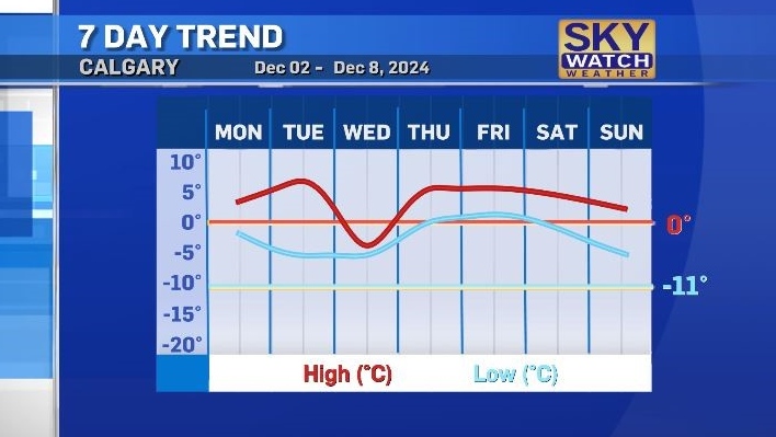
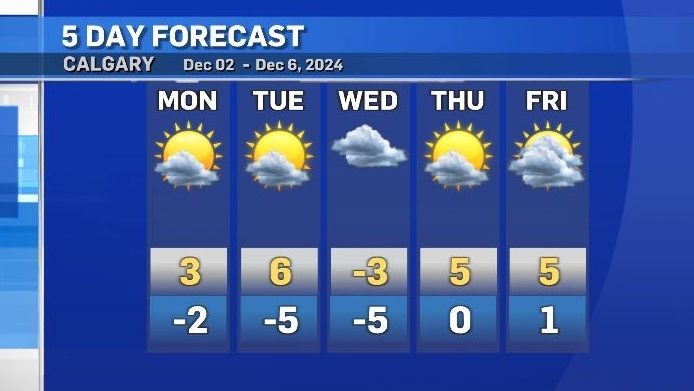
Daytime highs are expected to sit above freezing for six of the next seven days, and overnight lows will range from -5 C to 1 C.
This week is likely to bring a mix of sun and cloud, and that, along with a westerly flow, will help melt some of the remaining snow on the ground.
Areas not under direct exposure to sunshine may experience a more distinct freeze-thaw cycle, leaving a layer of ice (most noticeable in the mornings) on sidewalks, parking lots and stairs.

CTVNews.ca Top Stories

Much of Canada is under an extreme weather alert this weekend: here's what to know
From snow, to high winds, to extreme cold, much of Canada is under a severe weather alert this weekend. Here's what to expect in your region.
'I gave them a call, they didn't pick up': Canadian furniture store appears to have gone out of business
Canadian furniture company Wazo Furniture, which has locations in Toronto and Montreal, appears to have gone out of business. CTV News Toronto has been hearing from customers who were shocked to find out after paying in advance for orders over the past few months.
Fugitive U.S. rioter seeks asylum in Whistler amid warnings of more to come
An American citizen convicted of participating in the Jan. 6, 2021, riot on Capitol Hill and dodging jail time in Whistler may just be the start of an asylum-seeking rush, according to a prominent legal expert.
13-year-old Quebec kart racer has Formula 1 dreams
Quebec racer Alexis Baillargeon, 13, is looking to add to his collection of silverware in 2025, as the teen from L'Épiphanie has Formula 1 in his sights.
Thirty years on, is Quebec headed for another independence referendum?
On the eve of the 30th anniversary of Quebec's second independence referendum -- the first one was in 1980 -- it seems the tide could be turning again. Legault is deeply unpopular after six years in power, and the Parti Quebecois, with a young, charismatic leader, has been ahead in the polls for more than a year.
Soldier who died by suicide in Las Vegas told ex-girlfriend of pain and exhaustion after Afghanistan
The highly decorated Special Forces soldier who died by suicide in a Cybertruck explosion on New Year's Day confided to a former girlfriend who had served as an Army nurse that he faced significant pain and exhaustion that she says were key symptoms of traumatic brain injury.
Man arrested after committing five bank robberies in 10 days: Toronto police
A man accused of robbing five Toronto-area banks in a 10-day period has been arrested by Toronto police.
Four puppies abandoned in northern Ont. rescued, rehomed
On New Year's Day, a pair had gone for a drive on northern Ontario backroads near Markstay-Warren to look at the local wildlife when they came upon four puppies in the middle of the road in the cold.
Calgary woman stranded in Mexico after husband's death during diving trip
A Calgary woman is struggling to return home after her husband died while diving in Mexico, leaving her stranded and facing financial hardship.


