New Year's offers a 'toasty' start in Calgary, but falls quickly
UPDATE: I feel like I jinxed it. Like, there's five minutes left in the third period of a hockey game and a parent shouts out "Wow, she's going to get a shutout!"
You don't say it. You just don't.
And here I am, writing for Calgary this morning: "Environment Canada’s call for this evening’s wind chill is -38. I’m with ‘em… or within a degree of them. So, it’s not an extreme cold warning. But my word, is it ever close."
Yeah. It was. And now we're back under an Extreme Cold Warning.
Quite a few spots experienced a surge in overnight wind chill potential. Calgary, according to the Hourly Forecast from EnvCan, does indeed stay under -40, but now it's by a single degree. So at that point, do you split the difference? Probably not. Environment Canada made the right call. Even if my Twitter is inundated with stuff like this, now:
I understand. Really, was anyone going to say "cool, time to take advantage of that -38 wind chill" anyhow? Probably not. Still, these warnings are another eye-rollingly good reminder to spend some time indoors.
The bright side: I have NO change-ups to the weekend forecast on offer. We'll take that as we can.
A small impulse is driving those near-weightless flakes down Thursday morning – if they end up amounting to a full centimetre, it certainly won’t feel like it on the shovel (or the broom).
Calgary left the warnings for extreme cold behind Wednesday afternoon, but there’s a strong chance to see a resurgence next week.
I’ll dive into that in a second. First, it’s important to note this page here.
For the sake of saving you a click (but it’s a fun reference, if time allows), that’s Environment Canada’s Warning Criteria page. Extreme cold warnings exist in the event of a -40 wind chill. Calgary and portions of the foothills all the way up into central Alberta are no longer at risk of a -40 wind chill. That really is all it means.
Environment Canada’s call for this evening’s wind chill is -38. I’m with ‘em… or within a degree of them. So, it’s not an extreme cold warning. But my word, is it ever close.
The Pacific low setup remains a solid “go” as we get to Saturday; west wind gusts in Calgary are looking to reach the 40 km/h marker, and for the southwest corridor of our province, 80 km/h through this time. We’ll see our province’s “hot spot” hit a positive marker. Even Calgary proper may end up above zero, if briefly. I’m not yet confident in that, for sure, but I’m not dismissive of it, either.
This will make for fair conditions through the weekend, but the jet stream will continue entering North America near Northern California and ripping across the southern U.S. Midwest. That means cold air isn’t far off again. Longer-range forecasts for the Calgary area show signs of improvement by the 9th or 10th of this month. Another week in the chill lies just ahead.
Your five-day forecast:
Tonight
- Clear, low -29 C
Friday
- New Year's Eve - Mainly sunny
- Daytime high: -20 C
- Evening: mainly clear, low -23 C
Saturday
- New Year's Day - Mainly sunny
- Daytime high: -4 C
- Evening: some cloud, low -9 C
Sunday
- Partly cloudy, late-day cold front
- Daytime high: 0 C
- Evening: snow, low -18 C
Monday
- AM flurries, then partly cloudy
- Daytime high: -19 C
- Evening: overnight flurries, low -25 C
Tuesday
- AM flurries, then partly cloudy
- Daytime high: -21 C
- Evening: overnight flurries, low -27 C
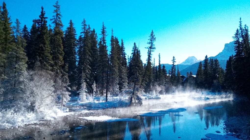
Our pic today is from Mike in Canmore, showing off a rather lovely winter scene, complete with a touch of radiation fog.
You can submit your photos here, email me here, or tweet them over.
Shopping Trends
The Shopping Trends team is independent of the journalists at CTV News. We may earn a commission when you use our links to shop. Read about us.


CTVNews.ca Top Stories

Mark Carney reaches out to dozens of Liberal MPs ahead of potential leadership campaign
Mark Carney, the former Bank of Canada and Bank of England governor, is actively considering running in a potential Liberal party leadership race should Justin Trudeau resign, sources tell CTV News.
'I gave them a call, they didn't pick up': Canadian furniture store appears to have gone out of business
Canadian furniture company Wazo Furniture, which has locations in Toronto and Montreal, appears to have gone out of business. CTV News Toronto has been hearing from customers who were shocked to find out after paying in advance for orders over the past few months.
WATCH
WATCH Woman critically injured in explosive Ottawa crash caught on camera
Dashcam footage sent to CTV News shows a vehicle travelling at a high rate of speed in the wrong direction before striking and damaging a hydro pole.
A year after his son overdosed, a Montreal father feels more prevention work is needed
New data shows opioid-related deaths and hospitalizations are down in Canada, but provincial data paints a different picture. In Quebec, drug related deaths jumped 30 per cent in the first half of 2024, according to the public health institute (INSPQ).
Rideau Canal Skateway opening 'looking very positive'
As the first cold snap of 2025 settles in across Ottawa, there is optimism that the Rideau Canal Skateway will be able to open soon.
Much of Canada is under a weather alert this weekend: here's what to know
From snow, to high winds, to extreme cold, much of Canada is under a severe weather alert this weekend. Here's what to expect in your region.
Jimmy Carter's funeral begins by tracing 100 years from rural Georgia to the world stage
Jimmy Carter 's extended public farewell began Saturday in Georgia, with the 39th U.S. president’s flag-draped casket tracing his long arc from the Depression-era South and family farming business to the pinnacle of American political power and decades as a global humanitarian.
'A really powerful day': Commemorating National Ribbon Skirt Day in Winnipeg
Dozens donned colourful fabrics and patterns Saturday in honour of the third-annual National Ribbon Skirt Day celebrated across the country.
Jeff Baena, writer, director and husband of Aubrey Plaza, dead at 47
Jeff Baena, a writer and director whose credits include 'Life After Beth' and 'The Little Hours,' has died, according to the Los Angeles County Medical Examiner.
Edmonton
-

'Flames were shooting higher than the garage': Block heater cords cause 2 fires in 2 days in Edmonton
Peter Claffey was shocked Thursday morning to find his truck in flames outside his southwest Edmonton home.
-
Health care dominated Alberta lobbying registry in 2024
Health care dominated the lobbying agendas of Alberta’s influencers this year after the provincial government promised to dismantle and decentralize the public health system.
-
Fire breaks out in north Edmonton home
A fire broke out in a north Edmonton home on Saturday afternoon.
Lethbridge
-

Family of hospitalized Lethbridge man in Thailand reach out for support
The family of a Lethbridge man is reaching out to the public for help after he suffered a series of medical emergencies while travelling in Thailand.
-
Checkstop Campaign ends in Lethbridge with 10 impaired drivers removed from the road: police
The Lethbridge Police service concluded its annual Checkstop Campaign over the holiday season, resulting in the removal of 10 impaired drivers from the road.
-
Threat made to Lethbridge casino deemed to be a ‘swatting’ hoax: police
Investigators with Lethbridge police determined that a threat made to a local casino Thursday night was deemed to be a ‘swatting’ hoax.
Vancouver
-

Body found in burned vehicle in Abbotsford park, police say
Homicide investigators have been called in to probe a suspicious death in Sumas Mountain Regional Park outside Abbotsford, police say.
-
Vancouver's Bloedel Conservatory welcomes visitors after months-long closure
After closing for just over two months for upgrades, Vancouver’s Bloedel Conservatory re-opened its doors the public Saturday.
-
Driver dead after collision with construction vehicle in Saanich, B.C.
A driver is dead after colliding with a construction vehicle in Saanich Friday night.
Vancouver Island
-

Driver dead after collision with construction vehicle in Saanich, B.C.
A driver is dead after colliding with a construction vehicle in Saanich Friday night.
-
WestJet denies compensation to Taylor Swift fan after flight cancellation
WestJet has denied compensation to a devout Taylor Swift fan whose cancelled flight triggered a 10-hour drive through the night from Prince George to make the singer's shows in Vancouver last month.
-
B.C. driver who tried to apprehend suspected impaired driver was impaired: RCMP
Mounties on Vancouver Island say a 50-year-old motorist who tried to apprehend a suspected impaired driver on New Year's Eve, was, in fact, impaired and was issued a 90-day driving prohibition by police.
Saskatoon
-

Extreme cold warning remains in effect for parts of Saskatchewan
The frigid weather continues to grip Saskatoon and parts of Saskatchewan as the extreme cold warnings are in effect across the prairies.
-
$20k of equipment stolen from rural Sask. Fire hall. And it's not the only one
Rural firehalls surrounding Saskatoon are having to deal with escalating thefts that could put rescue efforts in jeopardy.
-
Two people charged with murder after suspicious death on Sask. First Nation
A man and a woman have been charged with first degree murder after a 24-year-old man died of injuries on Saulteaux First Nation.
Regina
-

Family of man shot by Hamilton police hold vigil and rally in Regina
The family and community of a man shot by police in Hamilton in November continue to seek answers surrounding the circumstances of his death.
-
Regina woman turns to social media to find donor match for kidney transplant
A Regina woman currently waiting for a kidney transplant is now seeking a donor through a social media post.
-
Much of Canada is under a weather alert this weekend: here's what to know
From snow, to high winds, to extreme cold, much of Canada is under a severe weather alert this weekend. Here's what to expect in your region.
Toronto
-

Police search for suspects after jewelry store robbery at Burlington mall
Police are searching for multiple suspects following a smash-and-grab robbery at a mall jewelry store in Burlington Saturday afternoon.
-
'Ambassadors for their species in the wild': Toronto Zoo loses 2 long-term residents
Toronto Zoo has bid goodbye to two of its long-term residents over the past week.
-
'I gave them a call, they didn't pick up': Canadian furniture store appears to have gone out of business
Canadian furniture company Wazo Furniture, which has locations in Toronto and Montreal, appears to have gone out of business. CTV News Toronto has been hearing from customers who were shocked to find out after paying in advance for orders over the past few months.
Montreal
-

A year after his son overdosed, a Montreal father feels more prevention work is needed
New data shows opioid-related deaths and hospitalizations are down in Canada, but provincial data paints a different picture. In Quebec, drug related deaths jumped 30 per cent in the first half of 2024, according to the public health institute (INSPQ).
-
CTV News Montreal at 6 p.m. for Saturday, Jan. 4, 2025
Watch CTV News Montreal at Six on Saturday, Jan. 4, 2025 with anchor Matt Grillo.
-
Here are the locations of the latest Quebec measles outbreak
Quebec public health confirmed that officials are monitoring a measles outbreak that began in December in Montreal, Laval and the Laurentians.
Atlantic
-

‘We’re at a loss’: Salisbury, N.B., says goodbye to volunteer firefighter
Residents from the Town of Salisbury, N.B., lined Main Street Saturday afternoon to say goodbye to Capt. Tim Dryden of Salisbury Fire and Rescue.
-
Man assaulted in Costco parking lot in Moncton, N.B.
The Codiac Regional RCMP are investigating an assault that took place outside a Costco on Granite Drive in Moncton on Friday.
-
Maritime hockey teams go head-to-head in ‘blood feud’ for good cause
Three teams in the Quebec Maritime Junior Hockey League (QMJHL) are battling for a cause greater than hockey this January in the Battle of the Bridge – an annual blood donation challenge.
Winnipeg
-

'A really powerful day': Commemorating National Ribbon Skirt Day in Winnipeg
Dozens donned colourful fabrics and patterns Saturday in honour of the third-annual National Ribbon Skirt Day celebrated across the country.
-
Vacant apartment building demolished after third fire in 2 years
A vacant three-storey apartment building on Mountain Avenue has been demolished after its third fire since 2023.
-
Manitoba's top baby names for 2024
Manitoba’s top baby names remained mostly unchanged for 2024, though some new contenders made their way into the top 10.
Ottawa
-
 WATCH
WATCHWATCH Woman critically injured in explosive Ottawa crash caught on camera
Dashcam footage sent to CTV News shows a vehicle travelling at a high rate of speed in the wrong direction before striking and damaging a hydro pole.
-
Rideau Canal Skateway opening 'looking very positive'
As the first cold snap of 2025 settles in across Ottawa, there is optimism that the Rideau Canal Skateway will be able to open soon.
-
OTTAWA'S LRT
OTTAWA'S LRT All aboard Ottawa's new LRT line: What you need to know about the new north-south Line 2 and Line 4
Ottawa’s new north-south rail line will open to the public on Monday, Jan. 6, connecting downtown Ottawa and Riverside South with a spur to the Ottawa International Airport.
Northern Ontario
-

Suspect charged in northern Ont. road rage incident that went viral
A 37-year-old suspect has been charged in connection with a road rage incident last week in Temiskaming Shores.
-
Mark Carney reaches out to dozens of Liberal MPs ahead of potential leadership campaign
Mark Carney, the former Bank of Canada and Bank of England governor, is actively considering running in a potential Liberal party leadership race should Justin Trudeau resign, sources tell CTV News.
-
Sault, Ont., man claims Indigenous moose hunting rights without proof, fined $5,500
A hunter from Sault Ste. Marie, Ont., has been fined for moose hunting without a licence or proper documentation. He claimed Indigenous hunting rights but failed to provide any proof.
Barrie
-

Barrie declares significant weather event
The City of Barrie has declared a significant weather event on Saturday in response to the persistent snowfall in the area.
-
OHL game postponed due to weather
With the City of Barrie under a significant weather event declaration, Saturday evening’s Barrie Colts versus Kingston Frontenacs game at Sadlon Arena has been postponed.
-
‘Serious’ snowmobile crash under investigation
Police are investigating what is being deemed as a ‘serious’ snowmobile crash in Tay Township Saturday afternoon.
Kitchener
-

Police urging drivers to stay off the roads in Perth County
The Ontario Provincial Police are asking drivers to think twice before hitting the roads.
-
Three school board trustees call for town hall following director of education's departure
Three Waterloo Region District School Board trustees are joining the call for a town hall after a sudden shake up within the board.
-
Snow squall warnings for southwestern Ontario
Environment Canada says southwestern Ontario could get between 15 and 60 centimetres of snow by Saturday.
London
-

MP Peter Fragiskatos calls on Trudeau to resign
Prime Minister Justin Trudeau has lost the confidence of another prominent Liberal MP.
-
Poor weather postpones OHL Games in Owen Sound and Barrie
Inclement weather and travel conditions have forced the postponement of two games in the Ontario Hockey League Saturday.
-
Buffalo Bills legend Thurman Thomas among celebrities coming to St. Thomas, Ont.
The annual St. Thomas Sports Sports Spectacular presented by Hydro One has landed another superstar for the annual event later this month.
Windsor
-

Windsor fighter Randi Field signs to newly established MMA league
After a fight in March 2023, Windsor MMA fighter Randi Field feared a long list of injuries would derail her career.
-
MP Peter Fragiskatos calls on Trudeau to resign
Prime Minister Justin Trudeau has lost the confidence of another prominent Liberal MP.
-
Windsor Public Library hours changing Sunday
The hours of operation at the Windsor Public Library are changing on Sunday.


