Snowfall warnings issued south and west of Calgary ahead of multi-day snow event
It’s a classic southern Alberta springtime weather story – record heat one day and winter weather the next.
Four communities in Alberta set new maximum temperature records Tuesday, including Red Earth (northern Alberta), Slave Lake (north of Edmonton), Hendrickson Creek (north of Jasper), and Three Hills (northeast of Calgary).
The community of Masinasin in southern Alberta was the provincial hot spot Tuesday with a maximum temperature of 21.5 C.
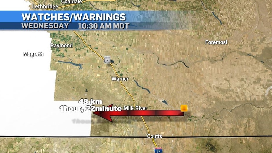
On Wednesday, snowfall warnings were issued 48 kilometres west of Masinasin, extending west to the B.C. border and north along the foothills.
 Hours after the community of Masinasin was the Alberta provincial hot spot on Tuesday (21.5 C), Environment and Climate Change Canada issued snowfall warnings 48 kilometres away.
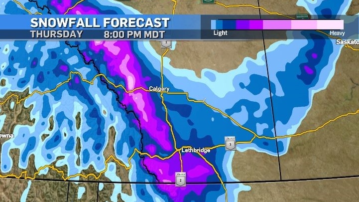
Environment and Climate Change Canada (ECCC) warned as much as 30 centimetres of snow could fall in some locations, but before the snow, rain and mixed precipitation are expected.
According to ECCC, Okotoks, High River and Claresholm could see between 10 and 20 centimetres of snow, and the agency warned, “Visibility may be suddenly reduced at times in heavy snow.”
Atmospheric profiles, surface temperatures, time of day and elevation will all be factors in determining how much snow falls and whether it accumulates.

Initially a frontal system will head toward the southern border of Alberta on Wednesday, with precipitation along the leading edge accompanied by strong north winds.
Overnight and early Thursday a second system will set up bringing the bulk of snow into the warned and surrounding regions.
The impact from this second system is highly dependant on where the system ends up – which is difficult to predict based on topography and corresponding environmental responses.
Upsloping flow is almost certain around the counter-clockwise rotation of the second low in southern Alberta, acting to amplify localized snowfall totals – however confidence in the track of this system is not high.
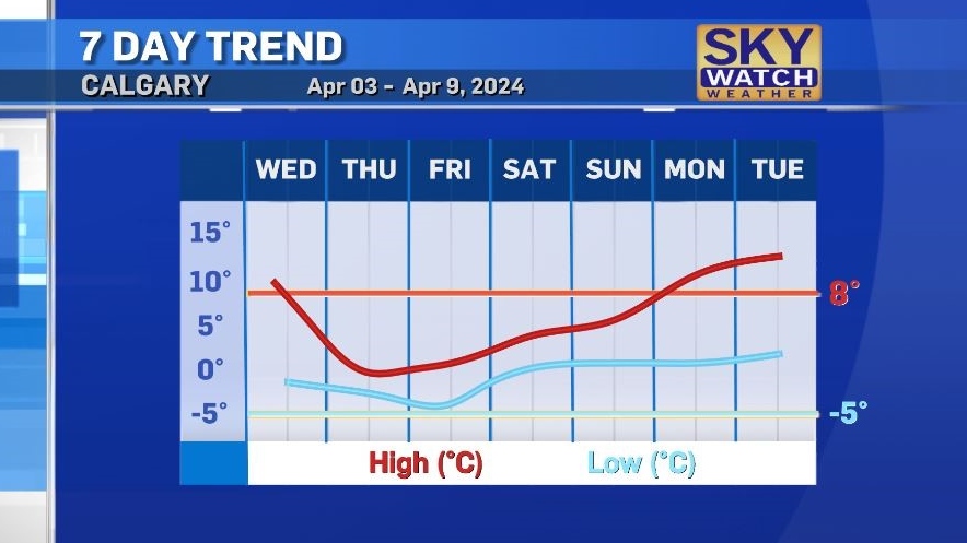
Daytime temperatures will remain below seasonal from Thursday until early next week, with a narrow gap between daily minimum and maximum (highs and low) temperatures.

The trough that is situated along the southern west coast Wednesday will eventually become a closed low as it tracks east over the weekend and by Tuesday a ridge of high pressure will bring temperatures in Calgary back up to the low teens.
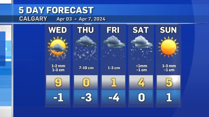
Snow should begin in Calgary by late evening Wednesday, with around 7 to 10 centimetres possible Thursday.
Surface temperatures will aid in road conditions, however areas that have pooling water, ice and/or snow will be vulnerable to icing up.
This is also true of bridge decks and open areas – depending on the duration of northerly flow over the aforementioned surfaced and surface saturation levels.

CTVNews.ca Top Stories

Liberal caucus chairs meeting to talk Trudeau today, PM attends Canada-U.S. cabinet committee
Prime Minister Justin Trudeau is back in Ottawa today, but with him yet to signal he's ready to address the snowballing resignation calls, the Liberal caucus' regional chairs have called a meeting today to discuss next steps.
When do I receive federal benefits this year? Payment dates for 2025
From the Canada Child Benefit to Old Age Security, federal payment dates have been determined for 2025. Find out when you can expect your payments.
Sea and Himalayan salts recalled in Canada: 'Do not use, serve or distribute'
Two brands of sea and Himalayan salt are being recalled in Canada due to pieces of plastic found in the products.
Ontario aiming to send out $200 rebate cheques later this month or early February
Ontarians should receive their $200 rebate cheque from the province by the end of January or early February, a government spokesperson confirmed in an email Friday.
'Mystery volcano' that erupted and cooled Earth in 1831 has finally been identified
An unknown volcano erupted so explosively in 1831 that it cooled Earth's climate. Now, nearly 200 years later, scientists have identified the 'mystery volcano.'
Atlanta hotel evacuated after carbon monoxide leak; 5 people hospitalized
A downtown Atlanta hotel was evacuated Friday after a suspected carbon monoxide leak that sent five people to hospitals to be evaluated, authorities said.
New Orleans inches toward normalcy while mourning victims of deadly New Year's rampage
Street performers and football fans returned to New Orleans streets as the city inched back toward normalcy while mourning victims of the deadly New Year's rampage in which an Army veteran plowed a pickup truck into revellers.
U.S. Speaker Mike Johnson is trying to save his job as a new Congress convenes
First-round balloting is underway at the U.S. Capitol, as the new Congress opened Friday with one major task at hand -- the election of the House speaker.
FORECAST Weather warnings issued for nearly all of Canada's provinces and territories
Nearly every province and territory in Canada is subject to weather advisories heading into the weekend.


