Special weather statement issued for Calgary, 15 to 25 cm of snow expected

Weather conditions in Calgary are expected to deteriorate rapidly starting Tuesday as a shift in the weather pattern brings Arctic air across the western Prairies.
This cold air will meet with a moist, Pacific air mass producing a classic spring scenario with heavy wet snow expected across the region.
Further complicating matters, the base of this trough (counter-clockwise rotation around a low pressure system) will sit along the southern edge of Alberta creating up sloping conditions.
Normally, weather moves from west to east across southern Alberta. During a scenario like the one currently developing in southern Alberta, systems can get anchored – or stall out - as they attempt to move in reverse (from east to west), and encounter the physical barrier of the Rocky Mountains.
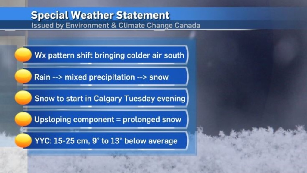
Special weather statement issued for Calgary
A wide-spread special weather statement was issued by Environment and Climate Change Canada (ECCC) Tuesday that includes all of southern Alberta.
A corresponding snowfall warning has been issued north of that statement, and includes Red Deer.
The snowfall warning extends north of Ponoka, east of Stettler, west of Jasper and north of the Yellowhead highway along the Alberta-B.C. corridor.
In the snowfall warning, the national weather agency advises motorists to "prepare for quickly changing and deteriorating travel conditions."
There is a good chance that snowfall warning will be expanded south as more certainty around the precipitation is firmed up.
According to the special weather statement, "Over 48 hours, snowfall totals of 15 to 25 cm are expected for parts of southern Alberta. Higher amounts are possible over the eastern slopes of the Rocky Mountains."
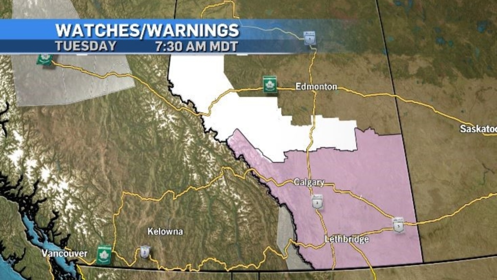 Weather advisories from ECCC on Tuesday, March 19, 2024 include a snowfall warning (white), a special weather statement (pink) and air quality advisories (gray). Unseasonably warm conditions over the weekend have left surface temperatures warm, meaning the snow from the start of this weather event will melt rather than accumulate on roadways and sidewalks. But as daytime highs sink below freezing and settle in a range colder than the average overnight low of -8 C, that snow will start to accumulate.
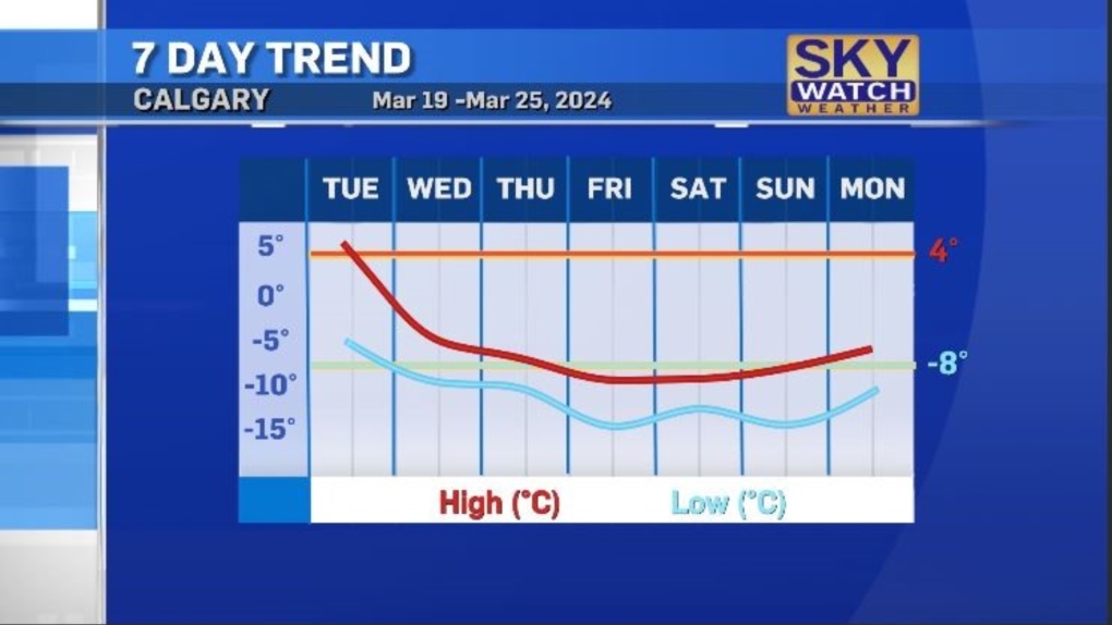 The total snowfall accumulation in Calgary will likely vary across the city, but the general range is expected to fall between 12 and 20 centimetres.
Visibility may be compromised in some communities as the snow is initially falling – due to a stronger wind while the frontal system is entering the region.
Rates of precipitation will dictate whether snowfall warnings are expanded and extended by ECCC. Snowfall warnings are issued in Alberta when 10 centimetres (or more) of snow falls over a period of 12-hours or less.
The bulk of precipitation is Calgary is expected on Wednesday and Thursday, however cloud cover and scattered flurries are likely until Saturday.
For the latest weather advisories from ECCC click here.
CTVNews.ca Top Stories

Montreal man dead after boat explodes in Fort Lauderdale
A Montreal man is dead and several others are injured after a boat exploded in Fort Lauderdale, Florida.
Mother-daughter duo pursuing university dreams at the same time
For one University of Windsor student, what is typically a chance to gain independence from her parents has become a chance to spend more time with her biggest cheerleader — her mom.
Azerbaijani airliner crashes in Kazakhstan, killing 38 with 29 survivors, officials say
An Azerbaijani airliner with 67 people onboard crashed Wednesday near the Kazakhstani city of Aktau, killing 38 people and leaving 29 survivors, a Kazakh official said.
Historical mysteries solved by science in 2024
This year, scientists were able to pull back the curtain on mysteries surrounding figures across history, both known and unknown, to reveal more about their unique stories.
King Charles III focuses Christmas message on healthcare workers in year marked by royal illnesses
King Charles III used his annual Christmas message Wednesday to hail the selflessness of those who have cared for him and the Princess of Wales this year, after both were diagnosed with cancer.
Alberta premier hopes for health reform payoff in 2025, regrets deferring tax cut
"It may have been better for Albertans if we'd implemented and then found a way to be able to pay for it."
NFL's Netflix debut on Christmas Day kicked off without a glitch
Mariah Carey opened Wednesday’s doubleheader with a taped performance of “All I Want for Christmas is You” before Patrick Mahomes, Travis Kelce and the two-time defending Super Bowl champion Kansas City Chiefs faced off against Russell Wilson, T.J. Watt and the Pittsburgh Steelers.
Second storm incoming for Christmas Day in southern B.C.
Environment Canada has issued a new series of weather warnings for British Columbia’s south coast Christmas morning.
Pope urges 'all people of all nations' to silence arms and overcome divisions in Christmas address
Pope Francis in his traditional Christmas message on Wednesday urged 'all people of all nations' to find courage during this Holy Year 'to silence the sounds of arms and overcome divisions' plaguing the world, from the Middle East to Ukraine, Africa to Asia.


