Storm risk for Calgary Wednesday afternoon/evening
AFTERNOON UPDATE: For their part, showers have subsided. What we're left with is trace potential through the mid-afternoon, and a very small chance of showers later this evening. If it's anything, it won't be a heck of a lot. Tomorrow still holds to thundershower potential, with a rather small amount of attached rainfall; these will be pocket storms rolling free of the foothills.
MORNING EDITION: An extremely eventful day yesterday. Let’s start here:
Among a number of funnel clouds, a short-lived, extremely isolated tornado looks to have done some damage. I imagine there's a decent chance that an official agency heads out that way sometime today to investigate this. Until then, there won't be an official update on whether this was a tornado or not.
We had loads of energy yesterday for storms, but we lacked strong wind shear — the vertical force that enhances storm strength. When there's a lot of energy and limited uplift, you achieve two major factors: one, the huge cumulus towers that make up these storms can sometimes lower a brief vortex below the cloud ceiling; AKA, a funnel cloud. Some of these can even touch down. The second effect is hail; hail requires a strong updraft within the storm to grow large, and without it, abundant pea-sized hail is likely. That's what we saw through parts of our city yesterday, resulting in this:
It's a protective instinct to take shelter in a hailstorm, but it's exponentially more dangerous in low visibility to stop on the road in these circumstances. Luckily, this didn’t result in any collisions.
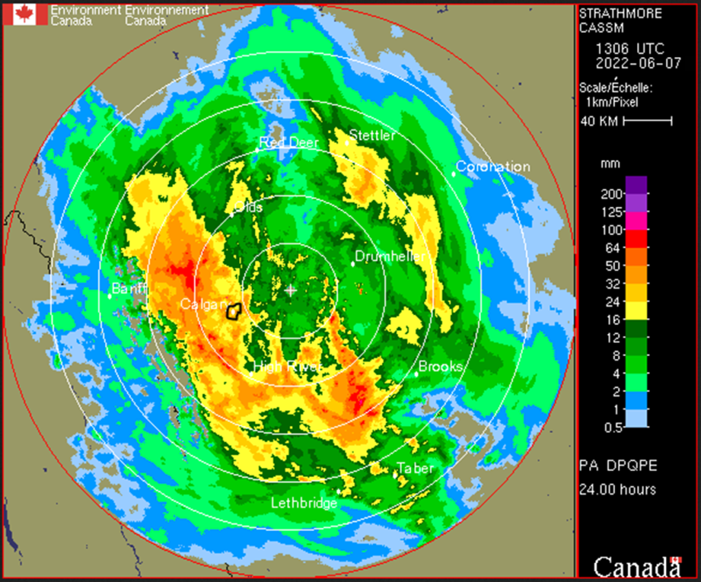
This brings us to the present; Sunday, we had 10.9 millimetres of rain. That was the wettest day of the year. Yesterday, we topped it; 24.2 mm. Overnight, the rain kept going. Here's the last 24 hours:

I circled Calgary. Sustained showers to the northwest yesterday afternoon and overnight resulted in over 60 mm coming down. This likely wraps just after the noon hour.
Tomorrow, a brief resurgence of moisture may result in thundershowers. Then, the jet stream tilts a wee bit further to the south, giving us a southwesterly profile, and a much warmer – and drier – lead-up heading into the weekend.
I mentioned in our seven-day trend yesterday that a drop was coming for Sunday, leading into more rain; that's now begun to materialize on Saturday afternoon. There's still a chance it falls back; it's a ways off, yet.
YOUR FIVE-DAY CALGARY FORECAST
Tuesday
- Evening: some cloud, low 7 C
Wednesday
- Partly cloudy, chance of afternoon thundershowers
- Daytime high: 21 C
- Evening: clear, low 7 C
Thursday
- Mainly sunny
- Daytime high: 23 C
- Evening: mainly cloudy, low 13 C
Friday
- Partly cloudy
- Daytime high: 23 C
- Evening: mainly cloudy, low 13 C
Saturday
- Partly cloudy, chance of afternoon showers
- Daytime high: 19 C
- Evening: cloudy, chance of showers low 11 C
Sunday
- Mainly cloudy, showers
- Daytime high: 17 C
- Evening: cloudy, chance of showers low 11 C
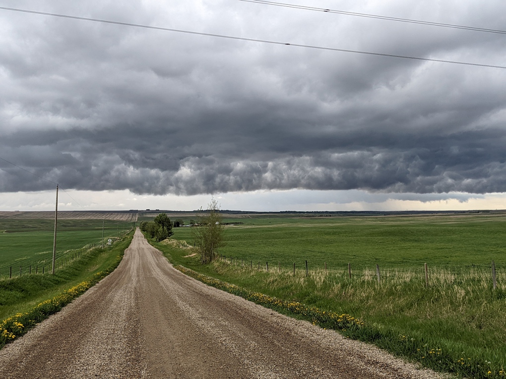
Today's pic was sent by Vince. The initial frontal boundary for yesterday's activity was a stationary front, where the warm and cold air masses hung together; that creates quite the cloud display!

Submit your weather photos here to see them featured in our article, and perhaps even as the pic of the day during our News at Six! You can also share my way on Twitter, or to our Instagram at @CTVCalgaryWeather.
CTVNews.ca Top Stories

UPDATED Anita Anand will not seek Liberal leadership
Transport Minister Anita Anand announced on social media Saturday she will not seek the leadership of the Liberal Party, nor will she run for re-election in the riding of Oakville.
'It's not realistic': Former PM Chretien thinks Trump will back off trade war
Former prime minister Jean Chretien says U.S. president-elect Donald Trump is likely to walk back his threat of punishing tariffs and the resulting trade war with Canada, because the Americans are too reliant on a number of Canadian exports, namely in the energy sector.
This Canadian teen lost her hands and feet to an infection. She's on a mission to share her story
A Canadian teen is reaching audiences around the world with powerful social media videos showing life without hands and feet – the price she paid after developing sepsis.
Heroes in action: Strangers lift car to rescue a woman pinned underneath
A group of good Samaritans teamed up with law enforcement this week to save an elderly woman pinned underneath her car in Lawerence, Mass.
Vancouver strip club's X account suspended over cheeky marquee message
The marquee at The Penthouse strip club in downtown Vancouver is known for its edgy comments on politics and pop culture.
University of Guelph sees positive norovirus test as 190 report feeling ill
An Ontario public health official says they've detected norovirus among a group of 190 people reporting symptoms of gastroenteritis at the University of Guelph over the last week.
'I'll never call him dad again:' Gisele Pelicot’s daughter says she suspects her father also drugged her for sexual abuse
Caroline Darian, the daughter of Gisele Pelicot who sustained years of horrific sexual abuse by her then-husband and other men, has described how she’s certain her father drugged her and strongly suspects she was raped too.
Tough lesson: Thousands of 'unqualified' teachers in Quebec schools
Monique Henry has been teaching English in Quebec for the better part of two decades without official certification. As a so-called "unqualified" teacher, she has had to learn her profession the hard way.
Puppies found freezing on the side of Middlesex road headed for rescue agency
Four puppies abandoned in the freezing cold on the side of a Middlesex County road are headed to a rescue agency this weekend.


