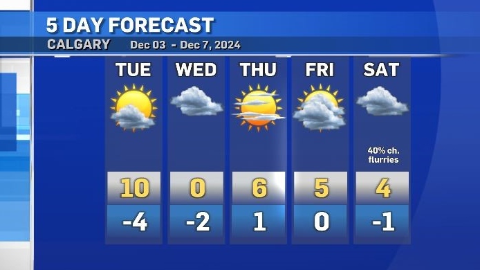
Tuesday morning temps more than 20 degrees warmer than average
Warm westerly winds that started on Monday night continued into Tuesday, elevating morning temperatures in many southern Alberta communities.
As of 6 a.m., it was already 9 C in Calgary, compared to a normal overnight low of -12 C.
Westerly winds are expected to peak around 30 km/h in Calgary Tuesday morning with gusts closer to 50 km/h, but a developing lee trough will interrupt this pattern by the early afternoon.
A lee trough is a low pressure system that forms on the leeward side of a mountain range, or in this case, on the Alberta side of the Rockies.
This low will go on to become a classic “Alberta clipper” - a fast-moving weather system associated with unsettled conditions east and south of Alberta.
Colder air will mix with precipitation overnight Tuesday and the morning commute in southern Alberta on Wednesday may include freezing drizzle and/or fog.
This disturbance will be brief with warmer air returningon Thursday and continuing until Saturday.
With sunshine most days and the enhanced evaporative qualities of a westerly flow, a freeze-thaw cycle will emerge in Calgary, meaning sidewalks and parking lots will likely become icy in the overnight periods.

CTVNews.ca Top Stories

Driver who entered Canada 'without stopping' at B.C. border crossing arrested: police
A man who illegally blew through the Canada-U.S. border crossing in Surrey, B.C., Sunday morning has been arrested, according to authorities.
Man responsible for New Year's truck attack previously visited New Orleans, Ontario, Egypt: FBI
The man responsible for the truck attack in New Orleans on New Year's Day that killed 14 people visited the city twice before and recorded video of the French Quarter with hands-free glasses, an FBI official said Sunday.
'It was just devastating': Southern Manitoba golf course clubhouse burns for second time in 4 years
A golf course clubhouse in Morden, Man. went up in flames Sunday for the second time in less than four years, and mere days after its reopening from the previous fire was celebrated.
Thousands are without power due to winter storm hitting Newfoundland and Labrador
Massive waves slammed Newfoundland and Labrador's coastline on Sunday, as a powerful winter storm left thousands without power.
Pamela Anderson, Ryan Reynolds among Canadians vying for Golden Globes tonight
Tonight’s Golden Globes will feature a strong Canadian presence, with British Columbia actors Pamela Anderson and Gabriel LaBelle among the first-time nominees.
WATCH Woman critically injured in explosive Ottawa crash caught on camera
Dashcam footage sent to CTV News shows a vehicle travelling at a high rate of speed in the wrong direction before striking and damaging a hydro pole.
Maserati driver critically injures one, seriously injures another in Surrey hit-and-run: police
The driver of a Maserati fled the scene of a high-speed crash in Surrey that sent two people to hospital, one in critical condition on Saturday night, according to authorities.
Motocross rider injured after executing jump during North American International Motorcycle Supershow
Christian Martinez, a motocross rider participating in the North American International Motorcycle Supershow in Mississauga, was rushed to the hospital after executing a big jump during the show, a source tells CP24.
Here’s why you should monitor your blood pressure, keep it in check
An Ottawa pharmacist says blood pressure is a good indicator of overall health, noting the importance of keeping it at healthy rates.


