Widespread snowfall warnings issued ahead of 'long duration' snow event
Snowfall warnings were issued across Alberta, B.C. and Saskatchewan ahead of a long duration weather event.
According to Environment and Climate Change Canada, “A long period of snowfall with total amounts of 15 to 25 cm is expected.”
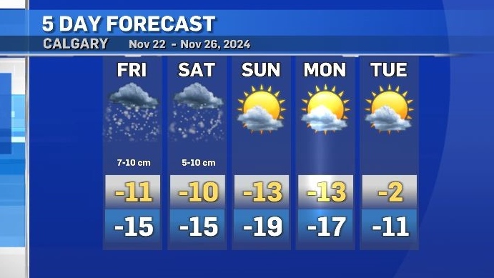
Snow will start in southern Alberta midday Friday and end late Saturday or early Sunday, with the heaviest totals expected on Saturday.
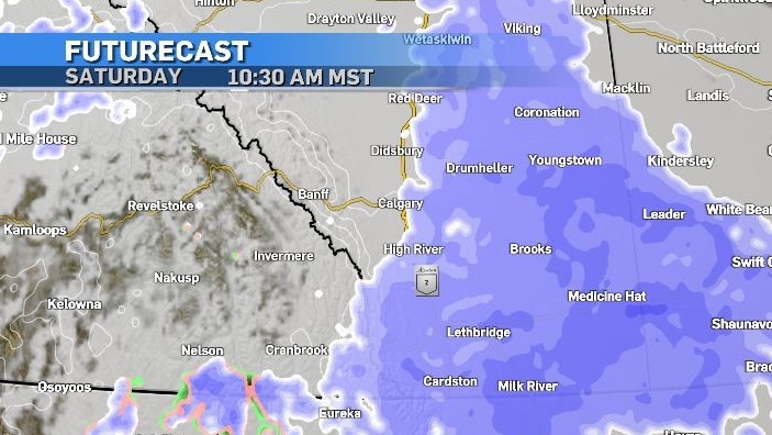
This system is pulling moisture from the south Pacific basin through the southern B.C. border where it will meet up with a colder air mass from the north.
The steering mechanisms include the counterclockwise rotation within this inverted trough meaning snowfall totals in southern Alberta will be highly variable and pinpointing the location of the highest accumulations is very difficult due to the physical barrier of the Rockies.
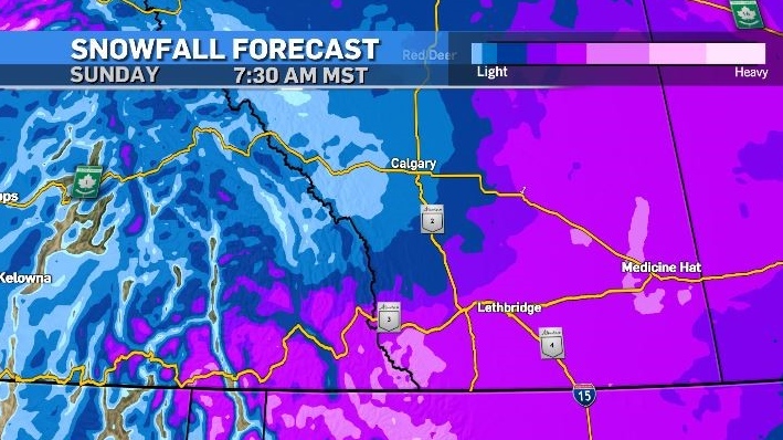
There is a better likelihood that the highest accumulations will be in the southeast corner of Alberta, however Calgary could get caught on the western edge of this.
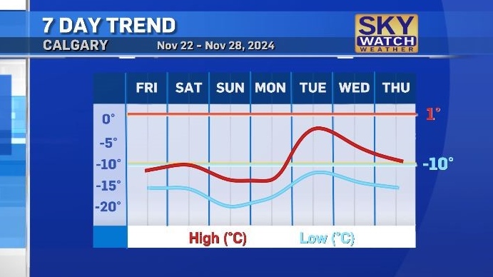
Both daytime highs and overnight lows will remain well below seasonal until at least the middle of next week, with windchil values making it feel close to -20 for most of the weekend.
CTVNews.ca Top Stories

Montreal man dead after boat explodes in Fort Lauderdale
A Montreal man is dead and several others are injured after a boat exploded in Fort Lauderdale, Florida.
Mother-daughter duo pursuing university dreams at the same time
For one University of Windsor student, what is typically a chance to gain independence from her parents has become a chance to spend more time with her biggest cheerleader — her mom.
Azerbaijani airliner crashes in Kazakhstan, killing 38 with 29 survivors, officials say
An Azerbaijani airliner with 67 people onboard crashed Wednesday near the Kazakhstani city of Aktau, killing 38 people and leaving 29 survivors, a Kazakh official said.
Historical mysteries solved by science in 2024
This year, scientists were able to pull back the curtain on mysteries surrounding figures across history, both known and unknown, to reveal more about their unique stories.
King Charles III focuses Christmas message on healthcare workers in year marked by royal illnesses
King Charles III used his annual Christmas message Wednesday to hail the selflessness of those who have cared for him and the Princess of Wales this year, after both were diagnosed with cancer.
Alberta premier hopes for health reform payoff in 2025, regrets deferring tax cut
"It may have been better for Albertans if we'd implemented and then found a way to be able to pay for it."
NFL's Netflix debut on Christmas Day kicked off without a glitch
Mariah Carey opened Wednesday’s doubleheader with a taped performance of “All I Want for Christmas is You” before Patrick Mahomes, Travis Kelce and the two-time defending Super Bowl champion Kansas City Chiefs faced off against Russell Wilson, T.J. Watt and the Pittsburgh Steelers.
Second storm incoming for Christmas Day in southern B.C.
Environment Canada has issued a new series of weather warnings for British Columbia’s south coast Christmas morning.
Pope urges 'all people of all nations' to silence arms and overcome divisions in Christmas address
Pope Francis in his traditional Christmas message on Wednesday urged 'all people of all nations' to find courage during this Holy Year 'to silence the sounds of arms and overcome divisions' plaguing the world, from the Middle East to Ukraine, Africa to Asia.


