After Monday, Calgary's temps will remain below freezing until Saturday
Daytime highs in Calgary over the weekend were warmer than average, sitting between 4 C to 6 C.
The maximum temperature on Monday will remain above seasonal, but that high of 2 C will also be the start of a cooler trend.
A shortwave trough moving from B.C. toward Alberta is expected to bring light and scattered snow throughout the southern portions of both provinces during the day Monday.
Behind that. an incoming ridge of high pressure from the Pacific will create instability along the eastern slopes of the Rockies, and snow is possible overnight.
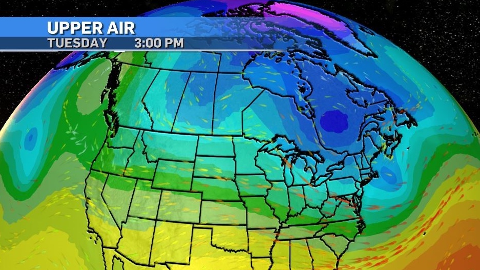
Communities along the west side of the QEII/Highway 2 corridor will see more snow compared to areas on the east side of the highway.

Persistent north winds will result in at least three days where both daytime highs and overnight lows will hover below seasonal ranges of 0 C and -12 C.
After Tuesday, snow is unlikely in Calgary and sunshine will assist in melting some of last weeks snowfall, but with daytime highs still below freezing, the thaw portion of the freeze-thaw cycle will not be as dramatic as it often is for this region.
As such, be cautious when navigating areas still covered in ice – like parking lots, sidewalks and driveways - as that ice could remain quite solid until the end of the week.

Shopping Trends
The Shopping Trends team is independent of the journalists at CTV News. We may earn a commission when you use our links to shop. Read about us.


CTVNews.ca Top Stories

U.S. president-elect's son shares post on X of Donald Trump buying Canada on Amazon
U.S. president-elect Donald Trump and those in his corner continue to send out strong messages about Canada.
Economists say more room to fall as Canadian dollar continues downward trend
Experts say the next few months are going to be rough for the Canadian dollar as it appears set to continue its downward trend.
Quebec fugitive killed in Mexican resort town, RCMP say
RCMP are confirming that a fugitive, Mathieu Belanger, wanted by Quebec provincial police has died in Mexico, in what local media are calling a murder.
5 rescued after avalanche triggered north of Whistler, B.C. RCMP say
Emergency crews and heli-skiing staff helped rescue five people who were caught up in a backcountry avalanche north of Whistler, B.C., on Monday morning.
Parties agree on the need to act on online harms, but time is running out for new law
Justice Minister Arif Virani is unapologetic about the money it would take to set up new regulators to tackle online harms under his proposed legislation.
Bill Clinton hospitalized with a fever but in good spirits, spokesperson says
Former U.S. president Bill Clinton was admitted Monday to Georgetown University Medical Center in Washington after developing a fever.
Trump again calls to buy Greenland after eyeing Canada and the Panama Canal
First it was Canada, then the Panama Canal. Now, Donald Trump again wants Greenland. The president-elect is renewing unsuccessful calls he made during his first term for the U.S. to buy Greenland from Denmark, adding to the list of allied countries with which he's picking fights even before taking office.
King Charles ends royal warrants for Ben & Jerry's owner Unilever and Cadbury chocolatiers
King Charles III has ended royal warrants for Cadbury and Unilever, which owns brands including Marmite and Ben & Jerry’s, in a blow to the household names.
Pioneering Métis human rights advocate Muriel Stanley Venne dies at 87
Muriel Stanley Venne, a trail-blazing Métis woman known for her Indigenous rights advocacy, has died at 87.
Edmonton
-

'Serious safety issues': Edmonton building where security guard was killed evacuated
An apartment building where a security guard was killed earlier this month has been evacuated.
-
Oilers enter holiday break on an NHL tear
The Edmonton Oilers' victory on Sunday over the Ottawa Senators was the 11th in their last 13 games.
-
City of Edmonton to lift Phase 1 parking ban Monday evening
The City of Edmonton will lift the Phase 1 parking ban on Monday at 5 p.m.
Lethbridge
-

'20 per cent increase': Interfaith Food Bank helps more than 900 households this holiday season
The last food bundles are heading out the door ahead of Christmas Day, as the Interfaith Food Bank nears the threshold of helping 1,000 households this holiday season.
-
Lethbridge Polytechnic announces new education and training opportunities for police
Lethbridge Polytechnic is taking steps to strengthen education and training opportunities for future police cadet graduates.
-
Milk River emergency department shuttered through Thursday
Alberta Health Services says the Milk River emergency department has temporarily closed due to a lack of physician coverage.
Vancouver
-

5 rescued after avalanche triggered north of Whistler, B.C. RCMP say
Emergency crews and heli-skiing staff helped rescue five people who were caught up in a backcountry avalanche north of Whistler, B.C., on Monday morning.
-
B.C. woman sentenced for impaired driving crash that killed retired Mountie
A Vancouver Island woman who was high on drugs when she crashed a car into a pickup truck, killing a retired Mountie and injuring his two passengers, "did not realize what was happening and took no steps to avoid the accident" a B.C. Supreme Court judge found.
-
'They have their families to feed': YVR janitors set to escalate job action
Approximately 230 janitors at Vancouver International Airport are set to escalate job action Tuesday at "undisclosed areas of the airport."
Vancouver Island
-

B.C. woman sentenced for impaired driving crash that killed retired Mountie
A Vancouver Island woman who was high on drugs when she crashed a car into a pickup truck, killing a retired Mountie and injuring his two passengers, "did not realize what was happening and took no steps to avoid the accident" a B.C. Supreme Court judge found.
-
5 rescued after avalanche triggered north of Whistler, B.C. RCMP say
Emergency crews and heli-skiing staff helped rescue five people who were caught up in a backcountry avalanche north of Whistler, B.C., on Monday morning.
-
Cleanup underway after rockslide derails train in B.C.
No injuries were reported after a rockslide derailed a freight train, sending railcars into British Columbia's Fraser River, on Sunday night.
Saskatoon
-

Personalized license plates on the rise in Saskatchewan
You may have noticed a few more vanity plates on Saskatchewan roads in recent years, and every one of them comes with a personal story.
-
'There are lines': In year-end interview, NDP leader says Moe went too far in election campaign
Saskatchewan’s two main political leaders had agreed before October's provincial election not to target the families of candidates during the campaign, says Opposition NDP Leader Carla Beck.
-
Sask. RCMP on the scene of rollover on Highway 40
The Saskatchewan RCMP said Highway 40 was closed Monday afternoon following a rollover just west of Hafford, a village just under 100 kilometres northwest of Saskatoon.
Regina
-

'A nice way to connect': Christmas card exchange between Sask. friends spans 60 years
What started out as a little holiday fun between two Regina friends has turned into a tradition that now spans six decades.
-
Dog lost in Saskatchewan during cross-country trip reunited with family
A family moving from Ontario to Alberta in November had a scare when their family dog got loose during a stop in Dafoe, Sask. and ran away.
-
Estevan police officer arrested following SIRT investigation
An officer of the Estevan Police Service (EPS) is facing several charges following an investigation by the province’s police oversight agency.
Toronto
-
U.S. president-elect's son shares post on X of Donald Trump buying Canada on Amazon
U.S. president-elect Donald Trump and those in his corner continue to send out strong messages about Canada.
-
After sustained pressure on Marineland probe, Ontario animal welfare body opens up
Ontario's little-known team of taxpayer-funded animal cruelty investigators recently issued its first-ever news release, years after launching in 2020.
-
Two people injured after car crash involving TTC bus near Yorkdale mall
Two people were taken to hospital after a car crash involving a TTC bus near Yorkdale mall early Tuesday morning, police say.
Montreal
-

Quebec doing better job at retaining immigrants, Atlantic Canada still struggling
Immigrants are increasingly choosing to stay in Quebec, according to a new report from Statistics Canada, but the same isn't true in the Atlantic region, which continues to lose newcomers to the rest of the country.
-
Quebec fugitive killed in Mexican resort town, RCMP say
RCMP are confirming that a fugitive, Mathieu Belanger, wanted by Quebec provincial police has died in Mexico, in what local media are calling a murder.
-
What's open and closed in Montreal during the holidays
Here's a list of what's open and closed for the holidays in Montreal.
Atlantic
-
Court of appeal certifies class action lawsuit against health authority, former nurse
A New Brunswick mother who is the lead plaintiff in a court case has received an early Christmas gift after the province’s top court certified her class-action lawsuit.
-
No need to dream, White Christmas all but assured in the Maritimes
An early nor'easter followed by a low-pressure system moving into the region all but ensure a Maritime White Christmas
-
CTV’s Katie Kelly solves decades old mystery involving “anchor” tattoo
It’s been almost two decades since a 21-year-old man from New Glasgow, N.S., got a tattoo of CTV’s Bruce Frisko, but it’s a piece of Maritime history that hasn’t been forgotten.
Winnipeg
-

An alleged sniper, pair of animal claims featured on MPI’s top five fraud list for 2024
From hitting animals that weren’t there to a sniper that didn’t exist, Manitoba Public Insurance has released its top five frauds of 2024.
-
Manitoba government to make permanent cut to gas tax
Manitobans can expect to see a permanent change at the gas pump as early as next week
-
Winnipeg police arrest corrections officer following sexual assault of a youth
A corrections officer at a “youth custody facility” has been arrested following a number of sexual assaults against a youth.
Ottawa
-
 NEW THIS MORNING
NEW THIS MORNING House to Home organization in Ottawa helps newcomers set up their lives
Refugees and some immigrants who arrive in Ottawa can come with nothing, and a local organization is working to help them build new lives by providing everything they need.
-
Traffic dispute threatens to dampen holiday spirit on Taffy Lane
A visit to Ottawa's Taffy Lane in Orléans is a staple this time of year, but a dispute amongst neighbours over traffic congestion is threatening to dim the magic of the holidays for one neighbour.
-
Ottawa mayor speaks on transit funding, federal turmoil in year-end interview
Ottawa Mayor Mark Sutcliffe spoke with CTV News on a variety of issues, including transit, the city budget and political turmoil on Parliament Hill in a year-end interview.
Northern Ontario
-

Fatal snowmobile crash in northern Ont. near Parry Sound
A 30-year-old has died following a snowmobile crash near Parry Sound on Sunday.
-
NEW
NEW NORAD crew waiting for Santa to fly over Canada as annual holiday track underway
Departing from the North Pole while we were all sleeping, Santa Claus' journey around the world bringing presents and Christmas cheer for all of the good boys and girls who believe is underway.
-
Two Sudbury men charged with hate-motivated crimes after pair injured downtown
Two 20-year-old men from Greater Sudbury are facing charges following what Greater Sudbury police are referring to as a ‘hate-motivated assault’ on Cedar Street.
Barrie
-

OPP R.I.D.E. program in full swing
OPP return a car to its rightful owner after a R.I.D.E. check in Midland.
-
Barrie's Jewish community celebrates Hanukkah brightly with 10-foot menorah
Barrie's Jewish community celebrates Hannukah on Wednesday.
-
Theft, vehicle break-ins, and fraud top police reports during holidays
Police in Barrie are urging residents to be vigilant this holiday season, as theft, theft from vehicles, and fraud consistently rank as the most reported crimes during this time of year.
Kitchener
-

Winter weather travel advisory before Christmas
Anyone planning to travel is being urged to be prepared as 5 to 15 cm of snow could hit a large portion of southern Ontario on Monday.
-
Beloved bookstore in Uptown Waterloo forced to close for months following fire
A beloved bookstore in Uptown Waterloo is bearing the brunt of some holiday misfortune.
-
Must-see moments of 2024: A superstar surprise, roundabout resident and CKCO studios come down
From a WWE surprise for a Guelph superfan, to the recovery of a lost aviation artifact, to a reporter getting the story right from the goose's mouth, here are some of our can’t-miss moments from 2024.
London
-

Blast of Ontario snow brings weather warnings, signs of white Christmas
A white Christmas is forecasted for parts of Ontario as winter weather and snowfall sweeps across the province Monday.
-
LGBTQIA+ community expresses concern over bus advertisements
The local LGBTQIA+ community is expressing concerns over an advertisement running on three city buses in London.
-
One in hospital following pedestrian and vehicle collision
One person is in hospital following a collision between a vehicle and pedestrian in Norfolk County.
Windsor
-

Restaurant staff aid in rescue of two men that fell into the frigid waters of the Detroit River
Windsor police say that shortly before 9:00 p.m. on Dec. 20, officers were called after a man fell into the water while standing too close to the marina wall. A second man jumped in to help him.
-
Early morning blaze that displaced two people deemed suspicious
Windsor fire was on scene of an early morning blaze in the 1500 block of Pelissier Street on Monday.
-
Child luring investigation sees Windsor resident charged
According to Essex OPP, 45-year-old Shaun Ouellette is facing charges of luring a person under 16 years of age by means of telecommunication.


