Avalanche risk increases in the Rockies – with more snow expected
One man has died after an early-season, wind slab avalanche in Kananaskis Saturday.
Above seasonal temperatures, strong chinook winds and snow have all been persistent in the mountains over the past few days with more snow expected Monday.
According to the Avalanche Canada's Nov. 12 forecast, there have already been a number of “natural and explosive triggered avalanches” within the previous 48-hour period.
The agency reports the snowpack saw an additional 10 to 30 centimetres of snow over the weekend with “generations of wind slabs within the snowpack which overlay a very weak base.”
Some of those wind slabs have failed naturally – including the deadly one on Saturday.
Strong west wind along with an additional 5 to 10 centimetres of snow was expected for the region on Monday.
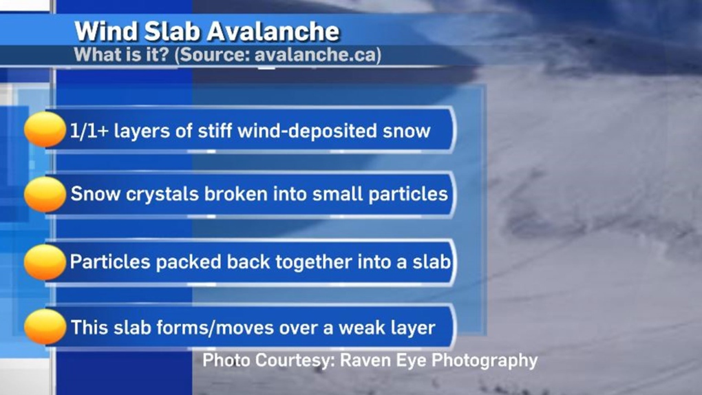
A wind slab avalanche can occur when the density of one layer of the snow pack changes due to external influences, resulting in one or more layers of stiff, wind-deposited snow situated on top of a weak layer. With a strong enough wind that new slab can settle on the other side of a mountain ridge – often at the top of a lee slope.
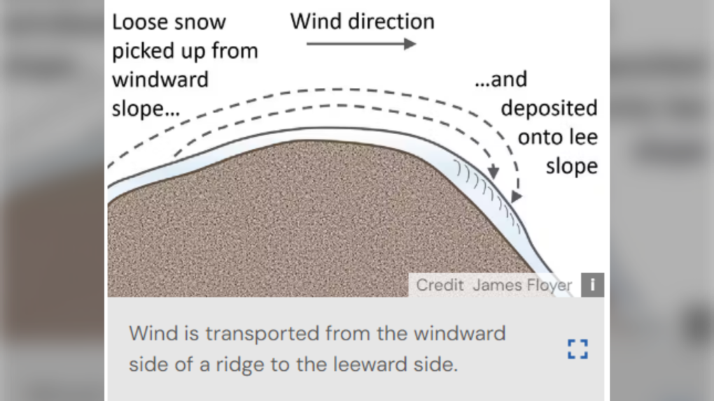
There are eight types of avalanches that Avalanche Canada forecasts for, with the avalanche season beginning in November and continuing through May.
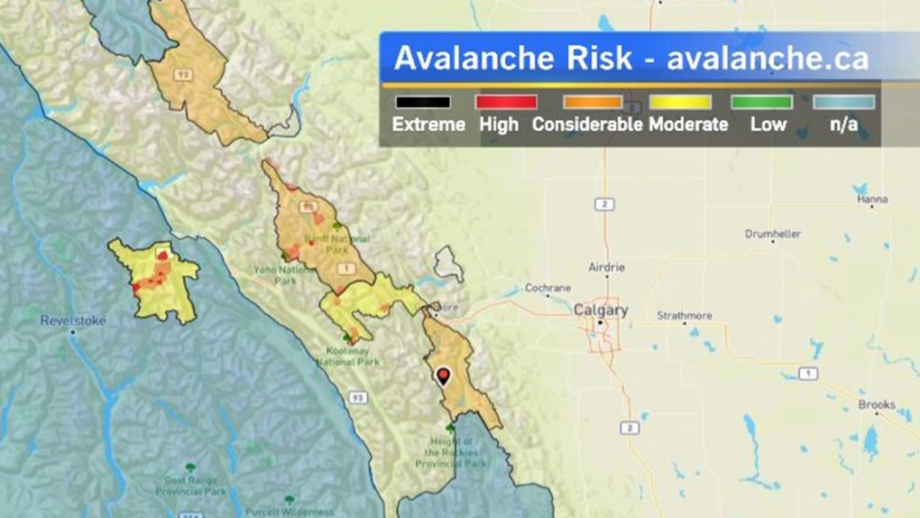
As of Nov. 13, there were already a few locations rated between a moderate to high avalanche risk, with most of those areas on the Alberta side of the Rockies.
A surface low pressure system will develop over central Alberta Monday with snow expected north of the low and above seasonal conditions forecast for the warm sector.
The daytime high in Calgary should hit 12C, which is 9 degrees above average.
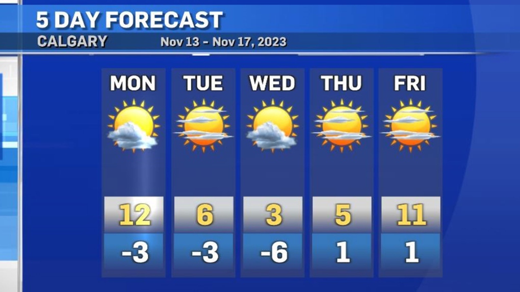
Temperatures will drop to a seasonal 3C by Wednesday, with off and on sunshine for the rest of the week.
CTVNews.ca Top Stories

Calgary woman stranded in Mexico after husband's death during diving trip
A Calgary woman is struggling to return home after her husband died while diving in Mexico, leaving her stranded and facing financial hardship.
Liberal caucus chairs meet to talk Trudeau, PM attends Canada-U.S. cabinet committee
Prime Minister Justin Trudeau was back in Ottawa today, but having yet to signal he's ready to address the snowballing resignation calls, the Liberal caucus' regional chairs called a meeting today to discuss next steps.
Sea and Himalayan salts recalled in Canada: 'Do not use, serve or distribute'
Two brands of sea and Himalayan salt are being recalled in Canada due to pieces of plastic found in the products.
Judge sets Trump's sentencing in hush money case for Jan. 10, but signals no jail time
In an extraordinary turn, a judge Friday set U.S. president-elect Donald Trump's sentencing in his hush money case for Jan. 10, but indicated he wouldn't be jailed.
N.S. community shocked by deaths of father, daughter; suspect was wanted in Toronto shooting
A Nova Scotia community is mourning the loss of two of its members after they were shot and killed in Halifax on New Year’s Eve.
CBSA increases travel cost reimbursement fees for 'inadmissible' foreign nationals
Foreign nationals who refuse or are unable to pay their own way home after being denied stay in Canada will soon face steeper financial penalties should they ever attempt to return.
'Mystery volcano' that erupted and cooled Earth in 1831 has finally been identified
An unknown volcano erupted so explosively in 1831 that it cooled Earth's climate. Now, nearly 200 years later, scientists have identified the 'mystery volcano.'
When do I receive federal benefits this year? Payment dates for 2025
From the Canada Child Benefit to Old Age Security, federal payment dates have been determined for 2025. Find out when you can expect your payments.
Ontario aiming to send out $200 rebate cheques later this month or early February
Ontarians should receive their $200 rebate cheque from the province by the end of January or early February, a government spokesperson confirmed in an email Friday.


