Expect icy conditions with an enhanced freeze-thaw cycle this week
A strong ridge of high pressure setting up along the B.C. coastline will become the main weather-maker for the west – including in southern Alberta.
In a classic adiabatic pattern, snow will fall on the B.C. side of the Rockies on Wednesday leaving dry air to descend along the leeward side – the Alberta side – of the mountains.
As that dry air flows toward the foothills, it will gain in temperature faster than it lost in temperature on its ascent on the windward side of the range.
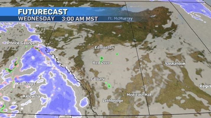
The result will be a persistent westerly pattern with elevated temperatures and enhanced evaporation – or snow melt across southern Alberta.
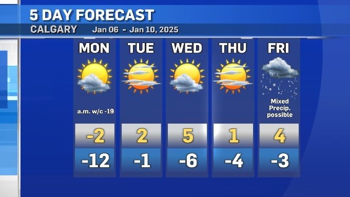
Daytime highs are expected to remain above freezing in Calgary starting Tuesday, and overnight lows will be warmer than the average daytime highs at times.
Since January is typically one of the coldest months across the region, any precipitation that does fall is usually in the form of snow, but with a warmer atmospheric temperature profile this week, rain or mixed precipitation is possible in the southeast corner of Alberta and central Saskatchewan Wednesday morning.
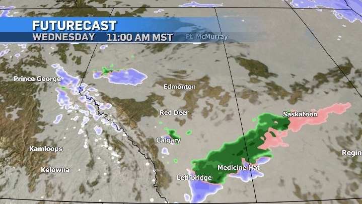
Melting will be enhanced across most of the region during the days this week, and cooler overnight temperatures will cause that melted snow to freeze on sidewalks, parking lots, and stairs.
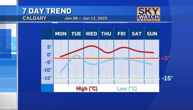
This temperature swing might also create issues with water mains and plumbing, as daytime highs are expected to be as warm as 5 C in Calgary by Wednesday.
CTVNews.ca Top Stories

DEVELOPING Trump is open to using 'economic force' to acquire Canada; Trudeau responds
Prime Minister Justin Trudeau said 'there isn’t a snowball’s chance in hell that Canada would become part of the United States,' on the same day U.S. president-elect Donald Trump declared that he’s open to using 'economic force' to acquire Canada.
Los Angeles residents flee fire as potentially 'life-threatening, destructive' winds gain strength
Firefighters scrambled to corral a fast-moving wildfire in the Los Angeles hillsides dotted with celebrity homes as a potentially 'life-threatening, destructive' windstorm hit Southern California on Tuesday, fanning the blaze seen for miles while roads were clogged with cars as residents tried to flee.
Patient dies in waiting room at Winnipeg hospital
An investigation is underway after a patient waiting for care died in the waiting room at a Winnipeg hospital Tuesday morning.
Canada has a navy ship near China. Here's what it's like on board
CTV National News is on board the HMCS Ottawa, embedded with Canadian Navy personnel and currently documenting their work in the East China Sea – a region where China is increasingly flexing its maritime muscle. This is the first of a series of dispatches from the ship.
DEVELOPING Threat against New Westminster courthouse triggers evacuation
A threat against the courthouse in New Westminster triggered evacuations in the city’s downtown Tuesday morning, according to authorities.
B.C. 'childbirth activist' charged with manslaughter after newborn's death
A British Columbia woman who was under investigation for offering unauthorized midwifery services is now charged with manslaughter following the death of a newborn baby early last year.
Man who exploded Tesla Cybertruck outside Trump hotel in Las Vegas used generative AI, police say
The highly decorated soldier who exploded a Tesla Cybertruck outside the Trump hotel in Las Vegas used generative AI including ChatGPT to help plan the attack, Las Vegas police said Tuesday.
David Eby among premiers heading to Washington to tamp down Trump tariff threat
The 'state of the federal government' following the announcement that Prime Minister Justin Trudeau would resign means Canada's premiers are taking the lead in the fight against threatened tariffs from U.S. president-elect Donald Trump, British Columbia Premier David Eby said.
Trump refuses to rule out use of military force to take control of Greenland and the Panama Canal
U.S. president-elect Donald Trump on Tuesday said he would not rule out the use of military force to seize control of the Panama Canal and Greenland, as he declared U.S. control of both to be vital to American national security.


