Hang in there, the warm up starts on Monday
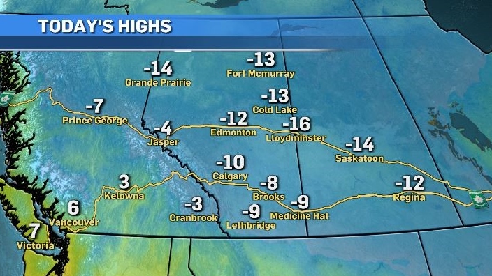
Cooler air from the north continues to flow across Alberta and Saskatchewan in a northwest to southeasterly direction and will remain in place until the end of the weekend.
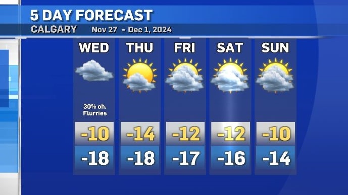
Conditions will be cloudy, with the only notable chance of snow for Calgary occurring midday on Wednesday.
The rest of this week will include cooler than average temperatures across Alberta, with daytime highs in Calgary sitting closer to values associated with average overnight lows.

After an unusually warm start to the month, temperatures in Calgary have been mostly below seasonal since the middle of the November.
In fact, it has been nine days since the temperature made it above freezing across the city. The average daily highs over that period range from 2 C to 0 C, with lows between -10 C to -11 C.
This trend will change by the end of the weekend, when a shift in weather patterns will drive the daily high up by at least 11 degrees from Sunday to Monday.

CTVNews.ca Top Stories

Here’s the latest on this weekend's winter storms in Canada
From snow, to high winds, to extreme cold, much of Canada is under a severe weather alert this weekend. Here's what to expect in your region.
Here’s why you should monitor your blood pressure, keep it in check
An Ottawa pharmacist says blood pressure is a good indicator of overall health, noting the importance of keeping it at healthy rates.
WATCH Woman critically injured in explosive Ottawa crash caught on camera
Dashcam footage sent to CTV News shows a vehicle travelling at a high rate of speed in the wrong direction before striking and damaging a hydro pole.
Big Dreams for ‘The Littlest Hobo’: Fans push for star on Canada’s Walk of Fame
When Terry Bush co-wrote and sang Maybe Tomorrow, the theme song for The Littlest Hobo, he thought it was just another gig—a catchy tune for a TV show about a wandering German Shepherd. Forty-five years later, that 'little tune' still tugs at heartstrings, pops up on playlists, and has even been known to be played at closing time in English pubs.
Air Canada passengers living with extra baggage fees
Some Air Canada passengers at Montreal’s Trudeau Airport were annoyed that they will now have to pay additional fees for their carry-on luggage.
Britain wants to get close to Trump. Will Elon Musk stand in the way?
It was not the start to 2025 that Keir Starmer wanted or expected: in the early hours of New Year’s Day, Elon Musk lobbed a series of angry posts and allegations towards the British prime minister, engulfing his government in a very public fight.
Mark Carney reaches out to dozens of Liberal MPs ahead of potential leadership campaign
Mark Carney, the former Bank of Canada and Bank of England governor, is actively considering running in a potential Liberal party leadership race should Justin Trudeau resign, sources tell CTV News.
This Canadian couple has been to 195 countries. Here's what they learned on their eight-year journey
Masha and Robert Glanville, a Canadian couple, sold everything they owned to travel the world full-time. With over 195 countries visited, they focus on mindful, eco-friendly travel and giving back. Here’s what they had to say about their global journey.
Peel police investigate possible connections between gunshot injury, luxury vehicle carjacking
Police are investigating possible connections between a gunshot injury and an attempted carjacking in Mississauga.


