Longer-range trend shows 15 days straight below freezing; Thursday, Friday, Saturday the coldest
The Arctic polar vortex (a large pocket of cold air at the North Pole, enclosed by the winds around it) will be disrupted from its usual pattern and expand/move south.
This means much colder temperatures than we have had for a long time.
Could it be record-breaking? If it dips a couple of degrees further than what is expected in Calgary, then yes!
There will likely be a number of communities in the province that will either get record-breaking cold or at least colder than any temperatures in the past 20 years.
Some cold air has already begun to creep into many areas in Alberta but we still have one more mild day before the colder air mass invades Calgary.
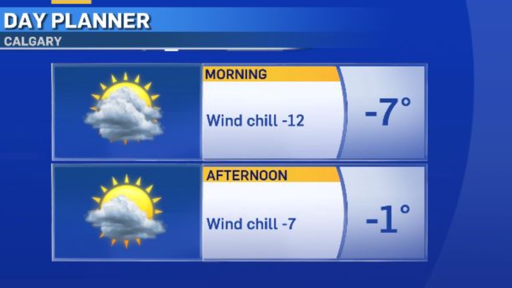
Expect a chilly morning with a wind chill of around -12.
In the afternoon, some sunshine and a high of -1 C.

The longer-range trend is showing 15 days straight below freezing (from Sunday, Jan. 7 to Sunday, Jan. 21) with this Thursday, Friday and Saturday being the coldest days in the stretch.
As you can see by the graphic below, Friday will be at or close to -30 C for our daytime high.
Expect overnight and morning wind chills in the minus 40s Thursday night through Sunday morning.
Also, our best chance of snow this week is Tuesday night to Wednesday.
The amount looks similar to the last burst of snow, two to six centimetres in YYC.

CTVNews.ca Top Stories

Donald Trump says he urged Wayne Gretzky to run for prime minister in Christmas visit
U.S. president-elect Donald Trump says he told Canadian hockey legend Wayne Gretzky he should run for prime minister during a Christmas visit but adds that the athlete declined interest in politics.
Historical mysteries solved by science in 2024
This year, scientists were able to pull back the curtain on mysteries surrounding figures across history, both known and unknown, to reveal more about their unique stories.
King Charles III focuses Christmas message on healthcare workers in year marked by royal illnesses
King Charles III used his annual Christmas message Wednesday to hail the selflessness of those who have cared for him and the Princess of Wales this year, after both were diagnosed with cancer.
Mother-daughter duo pursuing university dreams at the same time
For one University of Windsor student, what is typically a chance to gain independence from her parents has become a chance to spend more time with her biggest cheerleader — her mom.
Thousands without power on Christmas as winds, rain continue in B.C. coastal areas
Thousands of people in British Columbia are without power on Christmas Day as ongoing rainfall and strong winds collapse power lines, disrupt travel and toss around holiday decorations.
Ho! Ho! HOLY that's cold! Montreal boogie boarder in Santa suit hits St. Lawrence waters
Montreal body surfer Carlos Hebert-Plante boogie boards all year round, and donned a Santa Claus suit to hit the water on Christmas Day in -14 degree Celsius weather.
Canadian activist accuses Hong Kong of meddling, but is proud of reward for arrest
A Vancouver-based activist is accusing Hong Kong authorities of meddling in Canada’s internal affairs after police in the Chinese territory issued a warrant for his arrest.
New York taxi driver hits 6 pedestrians, 3 taken to hospital, police say
A taxicab hit six pedestrians in midtown Manhattan on Wednesday, police said, with three people — including a 9-year-old boy — transported to hospitals for their injuries.
Azerbaijani airliner crashes in Kazakhstan, killing 38 with 29 survivors, officials say
An Azerbaijani airliner with 67 people onboard crashed Wednesday near the Kazakhstani city of Aktau, killing 38 people and leaving 29 survivors, a Kazakh official said.


