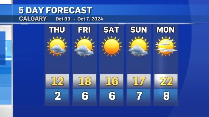
One more cool day before a week of warm weather

Thursday will be very similar to Wednesday, but with less wind and fewer clouds in southern Alberta.
As expected, morning temperatures on Thursday were around the freezing mark with mostly clear skies and cold air entering the province from the north.
A large and potent low pressure system parked over Hudson Bay was still impacting areas as far west as Alberta and as far south as the northern U.S. border to the Prairies.
The counter-closckwise rotation around that low has been grabbing Arctic air and spreading it across the country.

Conditions on Thursday will be varied across central and southern Alberta, with light rain early in the day in central Alberta, stronger winds in east-central Alberta (e.g. near Drumheller) by mid-afternoon, and mainly clear in southern Alberta.
The daytime high in Calgary is expected to reach 12 C on Thursday, before but an incoming ridge elevates both the maximum and minimum temperatures for nearly a week.
The weekend will be slightly warmer than the average 15 C, but the big gain will be overnight with lows five to seven degrees above seasonal.
Shopping Trends
The Shopping Trends team is independent of the journalists at CTV News. We may earn a commission when you use our links to shop. Read about us.


CTVNews.ca Top Stories

Back on air: John Vennavally-Rao on reclaiming his career while living with cancer
'In February, there was a time when I thought my career as a TV reporter was over,' CTV News reporter and anchor John Vennavally-Rao writes.
The winter solstice is here, the Northern Hemisphere's darkest day
The winter solstice is Saturday, bringing the shortest day and longest night of the year to the Northern Hemisphere — ideal conditions for holiday lights and warm blankets.
Poilievre writes to GG calling for House recall, confidence vote after Singh declares he's ready to bring Liberals down
Conservative Leader Pierre Poilievre has written to Gov. Gen. Mary Simon, imploring her to 'use your authority to inform the prime minister that he must' recall the House of Commons so a non-confidence vote can be held. This move comes in light of NDP Leader Jagmeet Singh publishing a letter stating his caucus 'will vote to bring this government down' sometime in 2025.
School custodian stages surprise for Kitchener, Ont. students ahead of holiday break
He’s no Elf on the Shelf, but maybe closer to Ward of the Board.
Kelly Clarkson's subtle yet satisfying message to anyone single this Christmas
The singer and daytime-talk show host released a fireside video to accompany her 2021 holiday album, “When Christmas Comes Around” that she dubbed, “When Christmas Comes Around…Again.
Judge sentences Quebecer convicted of triple murder who shows 'no remorse'
A Quebecer convicted in a triple murder on Montreal's South Shore has been sentenced to life in prison without chance of parole for 20 years in the second-degree death of Synthia Bussieres.
At least 2 dead, 60 hurt after car drives into German Christmas market in suspected attack
A car plowed into a busy outdoor Christmas market in the eastern German city of Magdeburg on Friday, killing at least two people and injuring at least 60 others in what authorities suspect was an attack.
16-year-old German exchange student dies after North Vancouver crash
A 16-year-old high school student from Germany who was hit by a Jeep in North Vancouver, B.C., last weekend has died in hospital, authorities confirmed.
Poilievre to Trump: 'Canada will never be the 51st state'
Conservative leader Pierre Poilievre is responding to U.S. president-elect Donald Trump’s ongoing suggestions that Canada become the 51st state, saying it will 'never happen.'
Edmonton
-

Second inmate dies at Edmonton Remand Centre in as many days
An inmate died at the Edmonton Remand Centre on Thursday night.
-
Child pornography charges laid against 52-year-old woman
A Sherwood Park woman has been charged with two child pornography offences.
-
'Proof will be in the pudding': Alberta changing how social agencies are funded
Alberta is looking to cut out the middleman when it comes to how social agencies are funded. On Friday, the province announced incoming changes to how services for Alberta's homeless population are funded.
Lethbridge
-

‘A moment of happiness’: Lethbridge 911 dispatchers getting help from dog to alleviate stress
Inside Lethbridge’s Public Safety Communications Centre (PSCC) is a four-legged team member weaving in and out from under the desks, shaking a paw and flopping over to get a belly rub all in an effort to reduce stress and anxiety of emergency dispatchers answering the calls of those in need of help.
-
'Fairly close' and ending 'as anticipated': Lethbridge-West stays with the Alberta NDP in byelection
What was expected to be a tight byelection took nearly three hours to call. Rob Miyashiro won to keep Lethbridge-West for the Alberta NDP.
-
'No one will go without': Lethbridge's Christmas Hope campaign enters final days
A trailer load of donated toys is helping the Angel Tree campaign cross the finish line with less than a week to go until Christmas.
Vancouver
-

Internet stranger's kind gesture restores Canucks fan's faith in humanity
A Nanaimo, B.C., couple is in awe at the kindness of an internet stranger who helped them track down a coveted Christmas gift.
-
16-year-old German exchange student dies after North Vancouver crash
A 16-year-old high school student from Germany who was hit by a Jeep in North Vancouver, B.C., last weekend has died in hospital, authorities confirmed.
-
As YVR fuel delivery workers strike, B.C. labour group declares cargo 'hot'
One week into a strike involving fuel delivery workers at the Vancouver airport, the B.C. Federation of Labour has issued a "hot" edict over their cargo.
Vancouver Island
-

B.C. man 'trying to appear cool' with loaded handgun at nightclub sentenced
A 23-year-old British Columbia man who pleaded guilty to carrying a loaded handgun inside a crowded nightclub has been sentenced to two-and-a-half years in prison.
-
Warrants issued for 'violent offenders' after Nanaimo jewelry store robbery
Authorities are asking for the public 's help finding two suspects wanted in connection with a Nanaimo, B.C., jewelry store robbery earlier this year.
-
B.C. teachers cultivate community through merry music videos
Although his classroom is filled with students now, Jeff Bordal will never forget how empty it once was.
Saskatoon
-

Sask. lawyers defend judge for staying fatal THC-impaired driving charge
The Saskatchewan Trial Lawyers Association is defending a provincial court judge, who’s facing backlash for staying a charge in a high-profile case involving the death of a child.
-
Saskatoon police release details about latest homicide
Saskatoon police are releasing new details about the city’s latest homicide, although no charges have yet been laid.
-
Search continues for man wanted in connection with all-day manhunt in northern Sask.
The Saskatchewan RCMP are still searching for 28-year-old Dallas Fulton, wanted in connection with a dangerous person alert sent out across the province in October.
Regina
-

'A sense of holiday spirit': Local shelter hosts Regina’s most vulnerable at annual Christmas dinner
For nearly 35 years, Souls Harbour Rescue Mission has been serving an annual Christmas dinner to Regina’s most vulnerable.
-
Drivers encouraged to check Highway Hotline before holiday travel
After receiving another big dump of snow over the past couple of days, Saskatchewan drivers have had to contend with some treacherous driving conditions.
-
Regina man creates snow sculpture to spread joy and inspire donations
A Regina man created a snow sculpture of a Santa head to spread joy and inspire donations to Big Brothers Big Sisters.
Toronto
-

6 arrested, 5 remain at large in auto theft ring that operated around Toronto Pearson Airport: police
Peel police have arrested six people and issued arrest warrants for five more suspects who are allegedly part of a Quebec theft ring responsible for stealing more than 100 vehicles in and around Toronto Pearson International Airport.
-
Police say break-and-enter suspects were in Canada for 'purpose of committing criminal offences'
Five Chilean nationals who police believe were in Canada for 'the purpose of committing criminal offences' have been charged in connection with half a dozen break-and-enters across the Greater Toronto Area (GTA).
-
'Enough is enough': Toronto Jewish school struck by gunfire for third time since May
A Jewish elementary school in Toronto has been struck by gunfire for the third time in the last seven months.
Montreal
-

Judge sentences Quebecer convicted of triple murder who shows 'no remorse'
A Quebecer convicted in a triple murder on Montreal's South Shore has been sentenced to life in prison without chance of parole for 20 years in the second-degree death of Synthia Bussieres.
-
Manhunt underway after woman, 23, allegedly kidnapped, found alive in river
A woman in her 20s who was possibly abducted by her ex is in hospital after the car she was in plunged into the Richelieu River.
-
After refusing, new official languages minister Bendayan acknowledges decline of French in Quebec
The newly appointed Minister for Official Languages, Rachel Bendayan, has backtracked after refusing to acknowledge the decline of French in Quebec despite the fact that all linguistic indicators show this to be the case.
Atlantic
-

Maritime weather: Warnings expanded as nor'easter approaches
Snowfall warnings are now in effect for mainland Nova Scotia and southeastern New Brunswick.
-
New highway between Lower Sackville, Dartmouth to open Friday
A new highway that runs between Lower Sackville, N.S., and Dartmouth, N.S., is scheduled to open on Friday.
-
Cancellations and closures in anticipation of Maritime storm
There are a number of closures in the Maritimes Friday in advance of heavy snowfall that’s anticipated through parts of the region.
Winnipeg
-

Bail denied for Winnipeg woman accused of killing animals in online videos
Warning: This story contains disturbing details. Discretion is advised. A Winnipeg woman accused of making videos of animals being tortured and killed that were sold on the dark web was denied bail.
-
Man suffers broken leg after being arrested by Winnipeg police; IIU investigating
The Winnipeg Police Service said the Independent Investigation Unit of Manitoba is investigating after a man suffered broken bones in his leg after being arrested.
-
'Good deals for Christmas': Turkey prices down from last year
With just days to go before Christmas, one of the big items for the big feast could be cheaper this year. Numbers from Agriculture and Agri-Food Canada show that during November this year, turkey prices were down from the same time last year.
Ottawa
-

Restaurants still waiting to see if GST/HST holiday impacts business
Reviews are beginning to come in from customers and restaurants a few days into the federal government's GST/HST holiday.
-
Man allegedly filming females in public washroom in business on Elgin Street, police looking for more victims
The Ottawa Police Service says a man has been arrested following a report alleging he was filming women inside a public washroom in a business on Elgin Street last weekend.
-
CTV and Move 100 Toy Mountain campaign raises $201,000
It will be a merry Christmas for 23,000 children in Ottawa this year, thanks to the community's generosity.
Northern Ontario
-

Problems at Extendicare Countryside in Sudbury must be fixed before taking in new residents
Extendicare Countryside in Greater Sudbury was ordered Dec. 16 by the province not to take in new residents.
-
Northern Ont. police investigate child luring attempt
Police are looking for an older man who tried to lure a child to get into his vehicle Friday in Sturgeon Falls, Ont.
-
Northern Ont. man illegally killed three moose, one deer
A man from the northwestern Ontario community of Dinorwic has been found guilty of multiple hunting offences and fined $6,500, banned from hunting for five years and placed on probation for 18 months.
Barrie
-

Multi-vehicle collision on Highway 11 in Oro-Medonte
Southbound traffic along Highway 11 through Oro-Medonte was brought to a crawl Friday after a multi-vehicle collision.
-
High school teacher charged with sexual assault amid allegations involving a student
A 51-year-old teacher from Georgina has been charged with sexual assault following allegations involving a student.
-
Driver charged after vehicle crashes into Barrie home
A driver was arrested Thursday night after a vehicle crashed into a home in Barrie.
Kitchener
-

Guelph man pleads guilty to fleeing fatal crash involving cyclist
A Guelph driver, who previously admitted to failing to stop after a fatal crash, instead plead guilty to a different charge on Friday.
-
School custodian stages surprise for Kitchener, Ont. students ahead of holiday break
He’s no Elf on the Shelf, but maybe closer to Ward of the Board.
-
Distillers not feeling the 'tax holiday' spirit
While some shoppers and store owners are celebrating the HST 'tax holiday' from the federal government, not all industries are feeling the holiday spirit.
London
-

Exodus of new home construction to sprawling rural communities sparks new strategy to lower lot prices in London
City council is betting that a dramatic boost to the supply of residential land within the city limits will lower the price of lots in new subdivisions and slow the number of people moving to bedroom communities in Middlesex County and beyond.
-
Man dies after falling from building: LPS
London police say a man has died after falling from a building.
-
Fire destroys London Cricket Club memorabilia, equipment
A fire destroyed thousands of dollars worth of property and memorabilia at the London Cricket Club.
Windsor
-

Clear Medical Imaging strike ends with arbitration agreement
The eight-week long strike action at Clear Medical Imaging has ended. According to officials, Unifor and the employer have agreed to binding arbitration.
-
Leamington resident now $50,000 richer
Helio Ferrieria of Leamington is celebrating after winning an ONTARIO 49 second prize worth $50,000 in the Dec. 4, 2024, draw.
-
Over $45,000 in cash and drugs seized: WPS
Two suspects have been arrested and over $45,000 in cash and drugs seized following an investigation by the Windsor Police Service (WPS).


