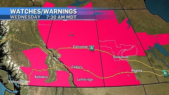
Some all-time heat records Wednesday while other locations may see tennis ball-sized hail
Extreme heat is expected to be the dominant weather story in Alberta and B.C. on Wednesday.
A very strong ridge of high pressure remains parked over the western portion of Canada and the United States, drawing in hot, humid air and pushing maximum temperatures as much as 10 to 13 C above average.
This system has been nearly stationary since the beginning of the week and is the reason dozens of maximum temperature records have been broken across Alberta and B.C. on Monday and Tuesday.
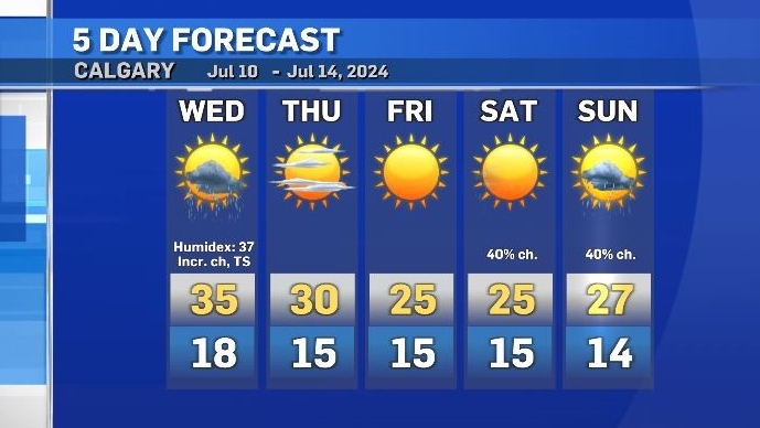
In Calgary, the forecast high on Wednesday is 35 C with a Humidex value of 37.
In Edmonton, the some models are forecasting highs of 37 C, and if that happens - and the temperatures creeps slightly higher than that – Edmonton would reach a new all-time daily high. The warmest temperature ever recorded in that city was 37.2 C on June 29, 1937.
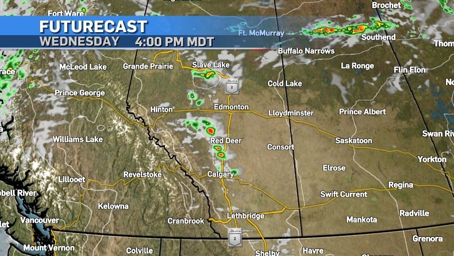
Wednesday will be the day that this weather pattern starts to break down as an incoming frontal system enters the province from the north.
As it the new system moves in, there is an amplified risk of severe storm development when the cold dry air encounters the warm and humid air mass sitting over Alberta.
In a synoptic set-up known as a “ring of fire” storms are likely to develop around the outer edges of that high – with rapid intensification.
Wind gusts of up to 90 km/h are possible, as well as tennis ball-sized hail. Tornadic activity is not off the table as rotation is likely with some of these storms.
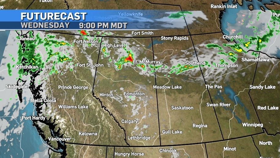
The most likely target area is in northern and central portions of our province later tonight but thunderstorms may also pop off the southern foothills today and impact areas as far south as Calgary in the mid-afternoon.
Daytime highs will start to moderate after Thursday, and overnight lows are also expected to cool slightly as we head in to the weekend.
Shopping Trends
The Shopping Trends team is independent of the journalists at CTV News. We may earn a commission when you use our links to shop. Read about us.


CTVNews.ca Top Stories

Judge sentences Trump in hush money case but declines to impose any punishment
U.S. president-elect Donald Trump was sentenced Friday in his hush money case, but the judge declined to impose any punishment, an outcome that cements his conviction while freeing him to return to the White House unencumbered by the threat of a jail term or a fine.
Foreign Affairs Minister Melanie Joly will not seek Liberal leadership
Foreign Affairs Minister Melanie Joly will not run for Liberal leadership. Up to now, Joly was widely considered a potential successor to Prime Minister Justin Trudeau, who recently announced he would resign as leader of the Liberal party.
'It's pretty scary': Toronto police investigating third tow truck-related shooting this week
Toronto police say they are investigating another tow truck-related shooting in Scarborough, the third such incident in just over 24 hours.
Canadian 'Super Scooper' plane grounded after hitting civilian drone over Los Angeles wildfires
A Canadian 'Super Scooper' aircraft fighting the Palisades Fire in Los Angeles had to be grounded after it hit a drone flying in restricted airspace over the devastating blaze on Thursday, the local fire department said.
Mel Gibson latest celebrity to share loss of home due to wildfires
Mel Gibson's home in Malibu was destroyed by the Los Angeles wildfires while he was away recording a podcast with Joe Rogan in Austin, Texas, Gibson has revealed.
'Mama is waiting for you': Woman appeals for return of 3-year-old son after ex-husband failed to bring him back to Canada
The mother of a three-year-old Toronto boy is urging her former husband who is wanted in a parental abduction investigation to bring their son back to Canada from India.
Wildfires latest: 10 confirmed dead as firefighters work to contain blazes in Los Angeles area
Firefighters are hoping for a break Friday from the fierce winds that have fueled massive blazes in the Los Angeles area, killing 10 people, obliterating whole neighborhoods and setting the nation’s second-largest city on edge.
Toronto police arrest suspected impaired driver spotted travelling on closed highway while en route to pick up kids
Police say that a 31-year-old Etobicoke woman was charged with impaired driving earlier this week after she was spotted travelling on a closed highway while on the way to pick up her children.
NEW
NEW Federal Liberals to pick new leader on March 9 as rules for leadership race are defined
The Liberal Party of Canada have announced leadership race rules late Thursday, including a significant increase in entrance fees and a requirement for voters to be Canadian citizens.
Edmonton
-
 WEATHER
WEATHER Josh Classen's forecast: Staying warm with some weekend snow
Precipitation is playing a bigger factor in the forecast over these next few days than it has in a while.
-
5 hurt in Red Deer industrial fire
Five people are in hospital following an explosion Thursday at a Red Deer industrial site.
-
'Elaborate' solar-powered encampment found in Fulton Creek
Edmonton police have dismantled two large encampments in the Fulton Creek area, including one with electricity.
Lethbridge
-

Lethbridge police seek help locating suspect in Wednesday night robbery
Lethbridge police are seeking public assistance to locate a suspect in releation to a robbery.
-
Southern Alberta woman sentenced to house arrest, curfew for fatal collision
A southern Alberta woman has been sentenced for a fatal collision that claimed the life of a 26-year-old Okotoks man in 2023.
-
2 people charged after multiple break-and-enters of Nanton businesses
A Nanton resident and a Claresholm resident have been charged in relation to multiple break-and-enters that took place in southeast Nanton.
Vancouver
-

B.C. Mounties say seized key fob kit could be used to steal 'virtually any vehicle'
A 48-year-old man was arrested Thursday after Mounties in Kelowna, B.C., recovered a stolen car containing illicit drugs and a car key programming kit that investigators say could be used to steal "virtually any vehicle that uses a key fob."
-
4 arrested after storage container theft: Kamloops RCMP
Mounties in Kamloops, B.C., say they foiled a break-and-enter in progress in the early hours of Thursday morning.
-
'Incalculably small' amount of diesel visible at site of 8,000-litre B.C. spill
Aerial surveillance over an area where thousands of litres of diesel was spilled last month off Vancouver Island shows most of the fuel is no longer visible on the water.
Vancouver Island
-
B.C. Mounties say seized key fob kit could be used to steal 'virtually any vehicle'
A 48-year-old man was arrested Thursday after Mounties in Kelowna, B.C., recovered a stolen car containing illicit drugs and a car key programming kit that investigators say could be used to steal "virtually any vehicle that uses a key fob."
-
'Incalculably small' amount of diesel visible at site of 8,000-litre B.C. spill
Aerial surveillance over an area where thousands of litres of diesel was spilled last month off Vancouver Island shows most of the fuel is no longer visible on the water.
-
Foreign Affairs Minister Melanie Joly will not seek Liberal leadership
Foreign Affairs Minister Melanie Joly will not run for Liberal leadership. Up to now, Joly was widely considered a potential successor to Prime Minister Justin Trudeau, who recently announced he would resign as leader of the Liberal party.
Saskatoon
-

Saskatoon man killed in collision with semi
A 35-year-old man from Saskatoon is dead after RCMP say the car he was driving collided with a semi on Highway 14 Thursday afternoon.
-
'They are hopeless': Saskatoon family desperate to bring sisters to Canada
Two Saskatoon women are desperately trying to get their loved ones out of Afghanistan, as the Taliban continues to oppress women.
-
Canada's unemployment rate ticks down
Canada's labour market capped the year with some 'good news,' adding 91,000 jobs in December, shattering economist expectations, though there are still calls for further interest rate cuts amid the threat of U.S. tariffs.
Regina
-

Sask. RCMP arrest Yorkton man, seize hundreds of grams of cocaine, fentanyl and meth
Saskatchewan RCMP say a 20-year-old Yorkton man is facing drug related charges after officers executed a search warrant of a home in the city on Wednesday.
-
Crews called to house fire on Retallack Street
Regina Fire says no one was injured in a house fire late Thursday night.
-
Saskatchewan newspaper predating province's formation ceases publication
Older than the province of Saskatchewan itself, the Estevan Mercury has now ceased publication after more than a century of operation.
Toronto
-

Toronto police arrest suspected impaired driver spotted travelling on closed highway while en route to pick up kids
Police say that a 31-year-old Etobicoke woman was charged with impaired driving earlier this week after she was spotted travelling on a closed highway while on the way to pick up her children.
-
Foreign Affairs Minister Melanie Joly will not seek Liberal leadership
Foreign Affairs Minister Melanie Joly will not run for Liberal leadership. Up to now, Joly was widely considered a potential successor to Prime Minister Justin Trudeau, who recently announced he would resign as leader of the Liberal party.
-
Canadian 'Super Scooper' plane grounded after hitting civilian drone over Los Angeles wildfires
A Canadian 'Super Scooper' aircraft fighting the Palisades Fire in Los Angeles had to be grounded after it hit a drone flying in restricted airspace over the devastating blaze on Thursday, the local fire department said.
Montreal
-

27 years after Quebec ice storm, Montrealers find themselves in LA wildfire's smoke
Montrealers, accustomed to ice storms, snow and cold, found themselves in Los Angeles this week as major wildfires raged throughout the region.
-
How to improve climate predictions? McGill researchers turn to 19th century letters
A team led by McGill University researchers came up with a method they hope could improve climate models over Africa by combining them with 19th century missionary records, refashioning dubious documents in a bid to better inform projections of global warming's impact.
-
NEW
NEW Federal Liberals to pick new leader on March 9 as rules for leadership race are defined
The Liberal Party of Canada have announced leadership race rules late Thursday, including a significant increase in entrance fees and a requirement for voters to be Canadian citizens.
Atlantic
-

N.B. RCMP seek two men suspected in Lutes Mountain home invasion
Police are looking for two men suspected in a home invasion in Lutes Mountain, N.B., last week. Police say two people broke into the home and restrained a man and woman who were inside.
-
Big jump in gas prices across the Maritimes overnight
There was a big jump in the price of gas in all three Maritime provinces overnight.
-
New Brunswick nurse wins 'Set for Life' lottery on Friday the 13th
A New Brunswick nurse is ‘set for life’ after winning a $675,000 lottery prize last month.
Winnipeg
-

Another big tax hike is potentially coming for Brandon residents
Brandon homeowners are facing the possibility of a double-digit tax increase in 2025.
-
Canadian 'Super Scooper' plane grounded after hitting civilian drone over Los Angeles wildfires
A Canadian 'Super Scooper' aircraft fighting the Palisades Fire in Los Angeles had to be grounded after it hit a drone flying in restricted airspace over the devastating blaze on Thursday, the local fire department said.
-
Winnipeg man charged with sexually assaulting children at daycare: police
Police have charged a man with sexually assaulting two children at an unlicensed daycare in Winnipeg.
Ottawa
-
 BREAKING
BREAKING Algonquin College closing Perth, Ont. campus as it deals with 'challenging fiscal times'
Algonquin College plans to close its campus in Perth, Ont. next year, as it deals with a multi-million deficit due to the new federal cap on international students and provincial funding shortfalls.
-
'Mom did most of the work': Ottawa police, paramedics help deliver baby boy in Centretown
A healthy baby boy was born Friday morning in Centretown with some help from Ottawa police and paramedics.
-
Ottawa Food Bank cutting food by 20-50 per cent to its agencies in 2025
The Ottawa Food Bank is cutting food donations to 98 food programs across the city by up to 50 per cent this year, as it deals with rising costs for food and an "all-time high" demand for food from the public.
Northern Ontario
-

Ontario homeowners left with expensive contracts after company appears to go out of business
Several homeowners in Ontario signed contracts with Provincial Smart Home Services promising rebates for their energy efficient upgrades, but now won't receive them as the company appears to have gone out of business.
-
Northern Ont. man fined $1,001 for dumping a bag of garbage
A Cochrane, Ont., man was fined $1,001 for dumping a single bag of garbage on public land.
-
Alta. man charged and released twice in one night for violence at northern Ont. hotel
Last weekend, an Alberta man was arrested and released for intimate partner violence at a northern Ontario hotel just hours after being charged and released for assaulting a teen with a weapon at the same location.
Barrie
-

Shift in bridge closes historical Bracebridge Silver Bridge indefinitely
Bracebridge's historical Silver Bridge will be closed for the foreseeable future.
-
Fatal cyclist crash in Thornbury
A serious collision between a vehicle and cyclist was investigated in Thornbury.
-
Man rolls car into ditch in Collingwood
Driver rolls and ditches car in Collingwood.
Kitchener
-
 NEW
NEWNEW Federal Liberals to pick new leader on March 9 as rules for leadership race are defined
The Liberal Party of Canada have announced leadership race rules late Thursday, including a significant increase in entrance fees and a requirement for voters to be Canadian citizens.
-
Dog and pedestrian hit in Kitchener: WRPS
A pedestrian and dog were hit by a vehicle in Kitchener Friday morning.
-
Driver arrested after crashing into Cambridge home
A man is facing multiple charges including impaired driving after a vehicle crashed into a Cambridge home Thursday evening.
London
-

Commissioners Road closed due to structure fire
The London Fire Department is on scene of an active structure fire at Commissioners Road and Highland Heights.
-
University Drive at Western University closed Tuesday
University Drive at Western University will be closed on Tuesday.
-
Foreign Affairs Minister Melanie Joly will not seek Liberal leadership
Foreign Affairs Minister Melanie Joly will not run for Liberal leadership. Up to now, Joly was widely considered a potential successor to Prime Minister Justin Trudeau, who recently announced he would resign as leader of the Liberal party.
Windsor
-

Suspects sought in Puce break-in
Essex County OPP are searching for two suspects in connection to a theft from a business in Puce.
-
Honda Civic, Ford Ranger and Volkswagen ID win North American vehicle awards
The Honda Civic hybrid won the 2025 North American Car of the Year award, while the Ford Ranger took the crown for the truck honors, and Volkswagen ID. Buzz won the utility award.
-
Foreign Affairs Minister Melanie Joly will not seek Liberal leadership
Foreign Affairs Minister Melanie Joly will not run for Liberal leadership. Up to now, Joly was widely considered a potential successor to Prime Minister Justin Trudeau, who recently announced he would resign as leader of the Liberal party.


