Warm and dry in southern Alberta Wednesday with some precipitation overnight
Wednesday will be very similar to Tuesday in southern Alberta with warm and dry conditions expected.
More snow and rain is forecast for the southern B.C. interior linked to a Pacific low pressure system.
That precipitation has prompted winter storm warnings along some higher elevation highways, including Kootenay Pass.
Most of that moisture will stay on the windward (or western) side of the Rockies for Wednesday, and warm and dry air will flow down into Alberta elevating temperatures.
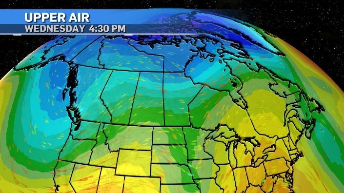
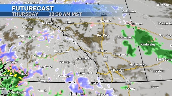
That low pressure system is expected to track east throughout the day Wednesday, and by the late evening some of that precipitation is expected to fall in central Alberta with the temperature dictating the form.
Areas closer to the eastern border will likely see rain initially, portions of north-central Alberta will have snow, and there is a chance of freezing rain near the capital.
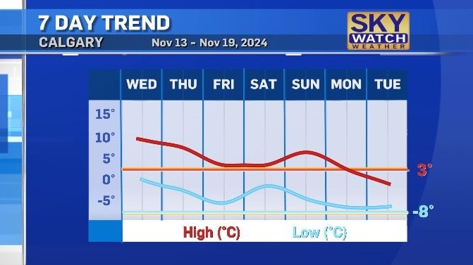
Both the daytime highs and overnight lows for the next few days will remain above seasonal ranges of 3 C and -8 C, but by the end of the weekend a colder air mass will sink down into the Pacific and then head into Alberta, bringing temperatures below seasonal and even below freezing by Tuesday.
CTVNews.ca Top Stories

Bird flu, measles top 2025 concerns for Canada's chief public health officer
As we enter 2025, Dr. Theresa Tam has her eye on H5N1 bird flu, an emerging virus that had its first human case in Canada this year.
Azerbaijan observes day of mourning for air crash victims as speculation mount about its cause
Azerbaijan on Thursday observed a nationwide day of mourning for the victims of the plane crash that killed 38 people and left all 29 survivors injured as speculation mounted about a possible cause of the disaster that remained unknown.
Prayers and tears mark 20 years since the Indian Ocean tsunami that killed some 230,000 people
People gathered in prayer and visited mass graves in Indonesia’s Aceh province on Thursday to mark 20 years since the massive Indian Ocean tsunami hit the region in one of modern history’s worst natural disasters.
Thousands without power on Christmas as winds, rain continue in B.C. coastal areas
Thousands of people in British Columbia are without power on Christmas Day as ongoing rainfall and strong winds collapse power lines, disrupt travel and toss around holiday decorations.
Donald Trump says he urged Wayne Gretzky to run for prime minister in Christmas visit
U.S. president-elect Donald Trump says he told Canadian hockey legend Wayne Gretzky he should run for prime minister during a Christmas visit but adds that the athlete declined interest in politics.
Ho! Ho! HOLY that's cold! Montreal boogie boarder in Santa suit hits St. Lawrence waters
Montreal body surfer Carlos Hebert-Plante boogie boards all year round, and donned a Santa Claus suit to hit the water on Christmas Day in -14 degree Celsius weather.
Historical mysteries solved by science in 2024
This year, scientists were able to pull back the curtain on mysteries surrounding figures across history, both known and unknown, to reveal more about their unique stories.
King Charles III focuses Christmas message on healthcare workers in year marked by royal illnesses
King Charles III used his annual Christmas message Wednesday to hail the selflessness of those who have cared for him and the Princess of Wales this year, after both were diagnosed with cancer.
Mother-daughter duo pursuing university dreams at the same time
For one University of Windsor student, what is typically a chance to gain independence from her parents has become a chance to spend more time with her biggest cheerleader — her mom.


