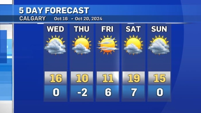
Warm Wednesday ahead of a cooldown to end the work week
Daytime highs on Wednesday will continue to trend above seasonal for central and southern Alberta.
A ridge of high pressure that has been elevating temperatures will start to track east late in the day, and by tomorrow the daytime highs will be noticeably cooler.
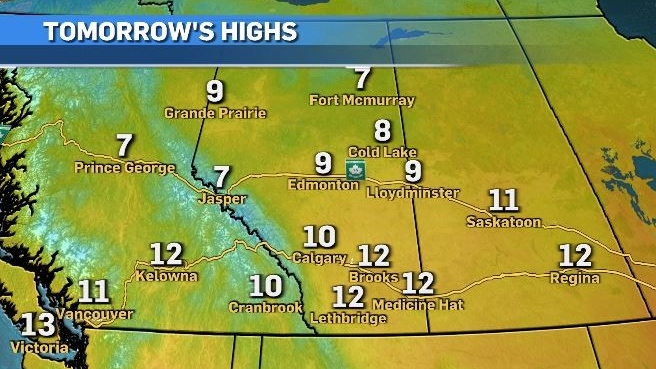
Along the western edge of the departing ridge, rain is likely and possibly even some late-season convective activity (thunderstorms).
Calgary has a slight chance of experiencing isolated showers Wednesday with a greater likelihood west and north of the city.
The heaviest accumulations are expected closer to the northern edge of the foothills and the capital region.
The weekend will bring a quick return to warmer than average conditions before a cooldown early next week.
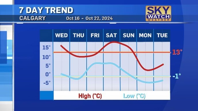
Calgary could see some mixed precipitation and/or snow by Monday.
Shopping Trends
The Shopping Trends team is independent of the journalists at CTV News. We may earn a commission when you use our links to shop. Read about us.


CTVNews.ca Top Stories

'We'll never be the 51st state,' Premier Ford says following Trump’s latest jab
Ontario Premier Doug Ford says Canada will 'never be the 51st state,' rebuking U.S. President-elect Donald Trump’s latest social media post.
B.C. man drops camera into ocean, accidentally captures 'breathtaking' whale video
Before it turned into an extraordinary day, Peter Mieras says it began being quite ordinary.
'Why would I box myself in?': Singh on why he won't commit to helping bring Trudeau's gov't down, yet
NDP Leader Jagmeet Singh says U.S. president-elect Donald Trump's looming tariff threat is part of the reason why he's not committing to voting non-confidence in Prime Minister Justin Trudeau's government.
Elon Musk comes out swinging against government spending package in early test of his political might
Elon Musk derided a Republican-backed government spending bill that if not passed by Friday night would lead to a government shut down.
Providing MAID to man on day pass from B.C. psychiatric ward was 'unlawful,' family alleges
A 52-year-old man who was provided with a medically assisted death while out on a day pass from a B.C. psychiatric hospital should never have been approved for the life-ending procedure, his family alleges in a recently filed wrongful death lawsuit.
Donald Trump says Canada becoming 51st U.S. state is 'a great idea.' Jean Charest calls the comment a 'wake-up call'
U.S. President-elect Donald Trump is taking aim at Canada once more, saying it would be 'a great idea' to make it America's ‘51st state.'
Fashion influencer Matilda Djerf apologizes following report she created a toxic workplace
A social media influencer has issued an apology after reports that she created a 'work environment filled with fear and psychological pressure' at her company.
Police suspect Utah father killed his wife and 3 kids, wounded son, then killed himself
Five people were found dead in a Utah home after a man apparently shot his wife and four children before killing himself, police said Wednesday. A 17-year-old boy survived but has a severe brain injury.
What's the best treatment for ADHD? Large new study offers clues
Stimulant medications and certain therapies are more effective in treating ADHD symptoms than placebos, a new study on more than 14,000 adults has found.
Edmonton
-

Snow covers Edmonton, Phase 1 parking ban taking effect Thursday
It was all hands on deck Tuesday night and Wednesday morning to start clearing roads as snow descended on the Edmonton area.
-
Edmonton pediatrician sentenced to 18 months on child pornography charges
An Edmonton pediatrician who was found guilty on child pornography charges last year will spend 18 months in jail.
-
Donald Trump says Canada becoming 51st U.S. state is 'a great idea.' Jean Charest calls the comment a 'wake-up call'
U.S. President-elect Donald Trump is taking aim at Canada once more, saying it would be 'a great idea' to make it America's ‘51st state.'
Lethbridge
-

Lethbridge County launches bi-weekly newsletter The County Insider
Lethbridge County has launched a new bi-weekly newsletter to help keep residents informed.
-
Southern Alberta’s first, purpose-built indoor pickleball facility opens in Lethbridge
In an effort to increase access to the fastest-growing sport around, a new purpose-built indoor pickleball facility has opened in Lethbridge -- the first-of-its-kind in southern Alberta.
-
University of Lethbridge looking for Blackfoot artist to create new school symbol
Blackfoot artists are being asked to submit designs for the creation of a new symbol that will be used by the University of Lethbridge and Pronghorn Athletics.
Vancouver
-

'I am suffering': B.C. hit-and-run victim pleads for driver to come forward
A hospitalized Burnaby, B.C., woman is asking the hit-and-run driver who put her there to come forward.
-
B.C. is the province least likely to want to join the United States, new poll suggests
British Columbians have little appetite to sever ties with Canada and join the United States, according to new polling.
-
B.C. mayor skeptical of feds' plan to bolster border security
On Tuesday, the Canadian government announced a $1.3-billion plan to bolster border security over the next six years.
Vancouver Island
-

Providing MAID to man on day pass from B.C. psychiatric ward was 'unlawful,' family alleges
A 52-year-old man who was provided with a medically assisted death while out on a day pass from a B.C. psychiatric hospital should never have been approved for the life-ending procedure, his family alleges in a recently filed wrongful death lawsuit.
-
B.C. is the province least likely to want to join the United States, new poll suggests
British Columbians have little appetite to sever ties with Canada and join the United States, according to new polling.
-
B.C. housing minister singles out 2 municipalities for lack of new home construction
In September 2023, the province gave 10 municipalities new home construction targets to meet in the first year under B.C.'s Housing Supply Act. The housing minster says two – West Vancouver and Oak Bay – didn’t come close.
Saskatoon
-

'Should move forward': Still no plea from Saskatchewan student who allegedly set teen on fire
More than three months have passed since a Saskatoon girl was set on fire, yet her classmate charged in connection with the incident has still not made a plea.
-
'Don't want to lose any more people': Saskatoon rally calls for solutions for growing homeless population
David Fineday doesn't want any more of his friends to die on Saskatoon streets this winter.
-
Sask. Teachers' Federation and province await decision from binding arbitration hearing
The Saskatchewan Teachers’ Federation (STF) and the province are now awaiting a decision from the Arbitration Board following a binding arbitration hearing.
Regina
-

'Create good Christmas memories for these kids': Regina schools experience Winter Wonderland
For the second year in a row, the Conexus Arts Centre was decorated as a Winter Wonderland and host to the Annual Community School Day.
-
Sask. Teachers' Federation and province await decision from binding arbitration hearing
The Saskatchewan Teachers’ Federation (STF) and the province are now awaiting a decision from the Arbitration Board following a binding arbitration hearing.
-
Highway conditions deteriorate across southern Sask. with snowfall warning in effect
Much of southern Saskatchewan remains under a snowfall warning on Wednesday afternoon, with 10 to 20 centimetres of snow expected to fall in some areas over the next 24 hours.
Toronto
-
'We'll never be the 51st state,' Premier Ford says following Trump’s latest jab
Ontario Premier Doug Ford says Canada will 'never be the 51st state,' rebuking U.S. President-elect Donald Trump’s latest social media post.
-
Porter plane lands safely at Toronto Pearson airport after mayday call
A Porter Airlines flight from Ottawa landed safely at Toronto Pearson airport Wednesday evening after making a mayday call.
-
'I still haven't slept:' Oshawa mom finds bullet hole in daughter’s dresser after 14 shots fired at housing complex
An Oshawa mom discovered bullet holes in her daughter’s dresser and in the ceiling of her living room early Wednesday morning after police say more than a dozen shots were “indiscriminately” fired at a housing complex overnight.
Montreal
-

Canadiens trade Justin Barron to Predators for Alexandre Carrier
The Montreal Canadiens have traded defenceman Justin Barron to the Nashville Predators in exchange for blueliner Alexandre Carrier.
-
Sentencing Friday for Quebecer convicted of killing spouse, two children
A Quebecer convicted this week in a triple domestic murder that left a woman and her two young children dead in a Montreal suburb will be sentenced at the end of this week, a Superior Court justice decided Wednesday.
-
Patrick Liard appointed interim CEO of Urgences-sante
Urgences-santé has confirmed that Patrick Liard will replace François Charpentier as the head of the public paramedic organization.
Atlantic
-

Mix of snow, rain Wednesday night and Thursday; nor'easter Friday night into Saturday
A strong coastal storm threatens to bring heavy snowfall to parts of the Maritimes this weekend.
-
'A gift this size is extraordinary': Family donates $1M to N.S. hospital
A hospital foundation in Dartmouth, N.S., received a significant donation on Wednesday to help advance innovative and exceptional care.
-
Three people face charges in murder of Saint John man
Three people are facing charges in connection with the murder of 52-year-old Allan Lee, whose remains were found in Saint John, N.B., in the summer.
Winnipeg
-

'Missed opportunities' identified in critical incident review of Earl Moberg case
The Winnipeg Regional Health Authority has apologized to Earl Moberg’s family after finding "missed opportunities" in the care of the 81-year-old man with advanced dementia who went missing a year ago.
-
'It gets us going': Federal government chips in $150 million for sewage plant
More money is flowing for Winnipeg's most expensive project, but it might not be enough to save ratepayers from sticker shock.
-
Threat against Thompson schools results in evacuation, classes cancelled
Classes will resume Thursday after multiple Thompson schools were threatened and the local high school evacuated.
Ottawa
-

New visitor centre opens in downtown Ottawa
A new visitor centre has opened in downtown Ottawa to assist the millions of tourists who flock to Canada's capital every year.
-
Inside the Shepherds of Good Hope's supportive housing on Merivale Road
CTV News Ottawa was invited to tour the facility at 1095 Merivale Rd. and speak to staff and residents following issues raised by those living nearby.
-
Here were the top baby names in Ottawa last year
Ontario unveiled the top baby names for 2023, and Olivia and Adam occupy the top spots in Ottawa.
Northern Ontario
-

Plans for wellness hub in Timmins moving forward
The Cochrane District Services Board has finalized the purchase of a former hotel in Timmins, where a proposed wellness hub would be located.
-
War of words escalates into lawsuits between Greater Sudbury, roads contractor
A bitter battle between Greater Sudbury and a southern Ontario roads contractor related to a troubled repair job on the Kingsway is now in the courts.
-
One child taken to hospital after Sudbury school bus rear ended
One child has been taken to hospital after a school bus was rear-ended on Municipal Road 35 east of Azilda in Greater Sudbury on Wednesday morning.
Barrie
-

County warden sounds off on ongoing boundary dispute between municipalities
As tensions heat up between Barrie and its neighbouring municipalities over a possible change in boundaries, the warden is working towards getting everyone on the same page.
-
Fatal multi-vehicle crash on Highway 93 under investigation
Provincial police are investigating a multi-vehicle collision that claimed the life of one person in Springwater Township Wednesday morning.
-
Ont. father says police failed his family after 911 calls went unanswered
An Orangeville man is calling for accountability from Ontario Provincial Police (OPP) after he says thieves armed with a gun broke into his home and left his family traumatized.
Kitchener
-

One person arrested for jewelry store robbery at Conestoga Mall in Waterloo
Police have made an arrest in a jewelry store robbery at Conestoga Mall in Waterloo, Ont.
-
Victim in Cambridge apartment fire dies, despite the efforts of Good Samaritan
A woman who was injured in a fire at a Cambridge apartment building on Tuesday has died from her injuries.
-
Multiple shots fired into Cambridge home
Police said multiple residences reported damages “consistent with shots fired.”
London
-

Child struck by vehicle south of London has died
According to an online fundraiser organized by a family friend, the boy who was hit by a driver south of London earlier this week has died.
-
Dream Lottery grand prize winners announced
Dream Lottery announced their top winners Wednesday at the Royal Oak Dream Home in Thorndale.
-
'It was quite spectacular': LHSC brass marvel at staff professionalism during weekend shooting, improved security on the way
The provincially appointed supervisor at London Health Sciences Centre said improved security measures will be installed in the coming months at both the Victoria and University hospital sites.
Windsor
-

'High visibility' initiative launching at 920 Ouellette in Windsor
While frequent calls are received, police say about 75 per cent of them are non-criminal — including well-being checks, ambulance requests and non-violent persons in crisis.
-
Semi-automatic rifle seized at Ambassador Bridge
Canada Border Services Agency officers seized a semi-automatic rifle at the Ambassador Bridge.
-
Leamington warns of scammers impersonating municipal staff to access homes
The Municipality of Leamington is warning residents about a scam involving individuals falsely claiming to represent its water services department in an attempt to access people's homes.


