Calgary expected to receive average June rainfall in just 48 hours
AFTERNOON UPDATE: We're locking a lot of this in, now. 70-90 mm is expected for much of Calgary, this with rainshowers beginning in the last hour in our city. That's the majority; there are isolated pockets that will still easily exceed 100 mm.
Per this tweet and the imaging above, the heaviest bands are passing through quickly. That said, we'll continue seeing periodic eruptions of heavier rainfall through the next 36 hours. The predominantl bursts of rain will occur Monday evening, early Tuesday afternoon, and again Tuesday evening.
Showers taper Wednesday morning, and then isolated pockets will occur on the heels of this soil moisture addition on Thursday and Friday.
Another update will follow the CTV Calgary news this evening.
MORNING EDITION: It is not abnormal for Calgary to receive 100 millimetres of rain in the month of June. Piling it all within two days, however, is a much different story, one hearkening back to a fateful event approximately nine years ago.
Rainfall warnings are up and active along the foothills, working a band through Nordegg and Banff, down through High River and Kananaskis. This includes Calgary.
Let's start by talking about what this event is, and what it isn’t.
WHAT IT IS
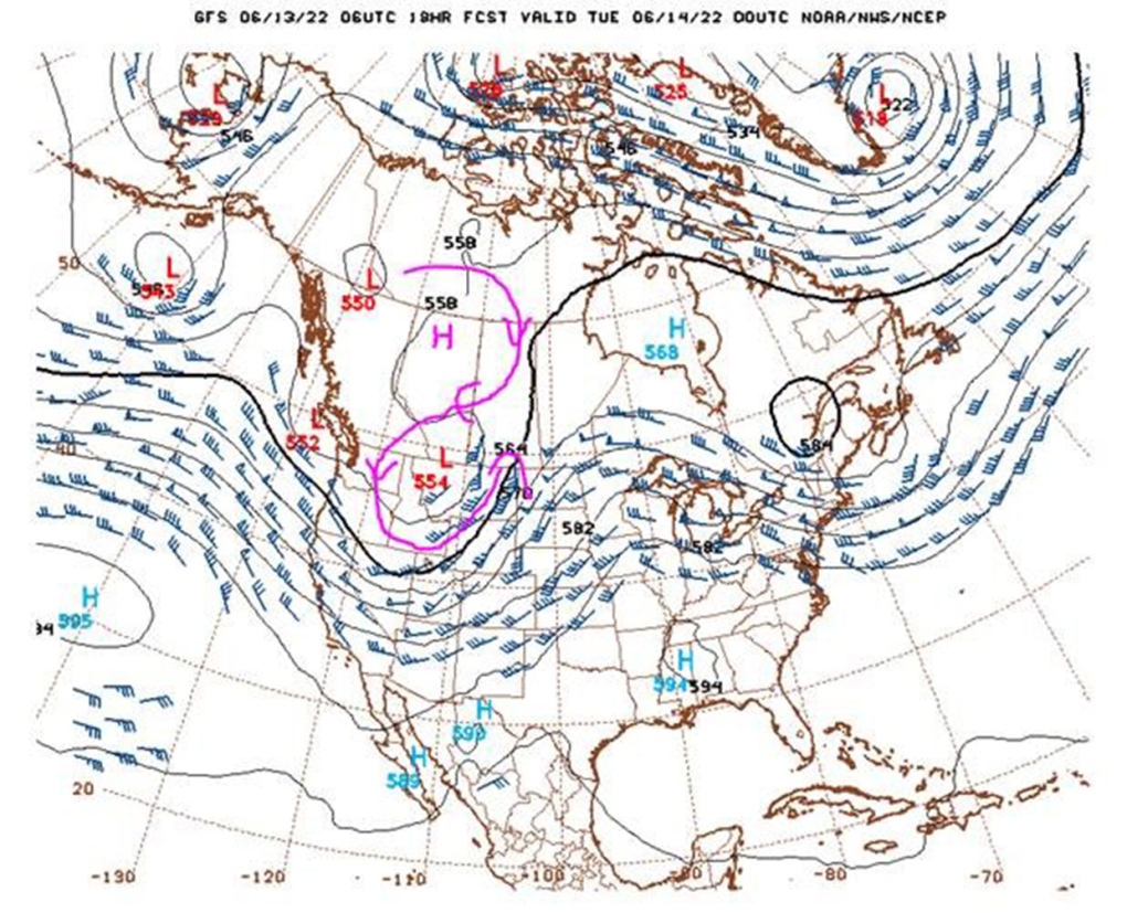
A significant rainfall event. Hands-down. This is a massive system rolling out of Montana, and we're aligned with its northern face, which pushes the moisture westward into the Rockies. Ensemble rainfall forecasts over the last 48 hours have bounced around a lot, from 30-120 mm, to 50-100 mm, and now we've settled in at 80-100 mm set to fall through Monday, Tuesday and early Wednesday. Because of the storm’s movement and potential for portions of the storm to dig in, isolated regions could exceed 100 mm to the tune of even 150 mm. It's not insignificant; the measures one takes should include the removal of valuable items and documents from basements and to ensure that sump pumps are in prime working order.
The riverways are experiencing watches and warnings of their own:
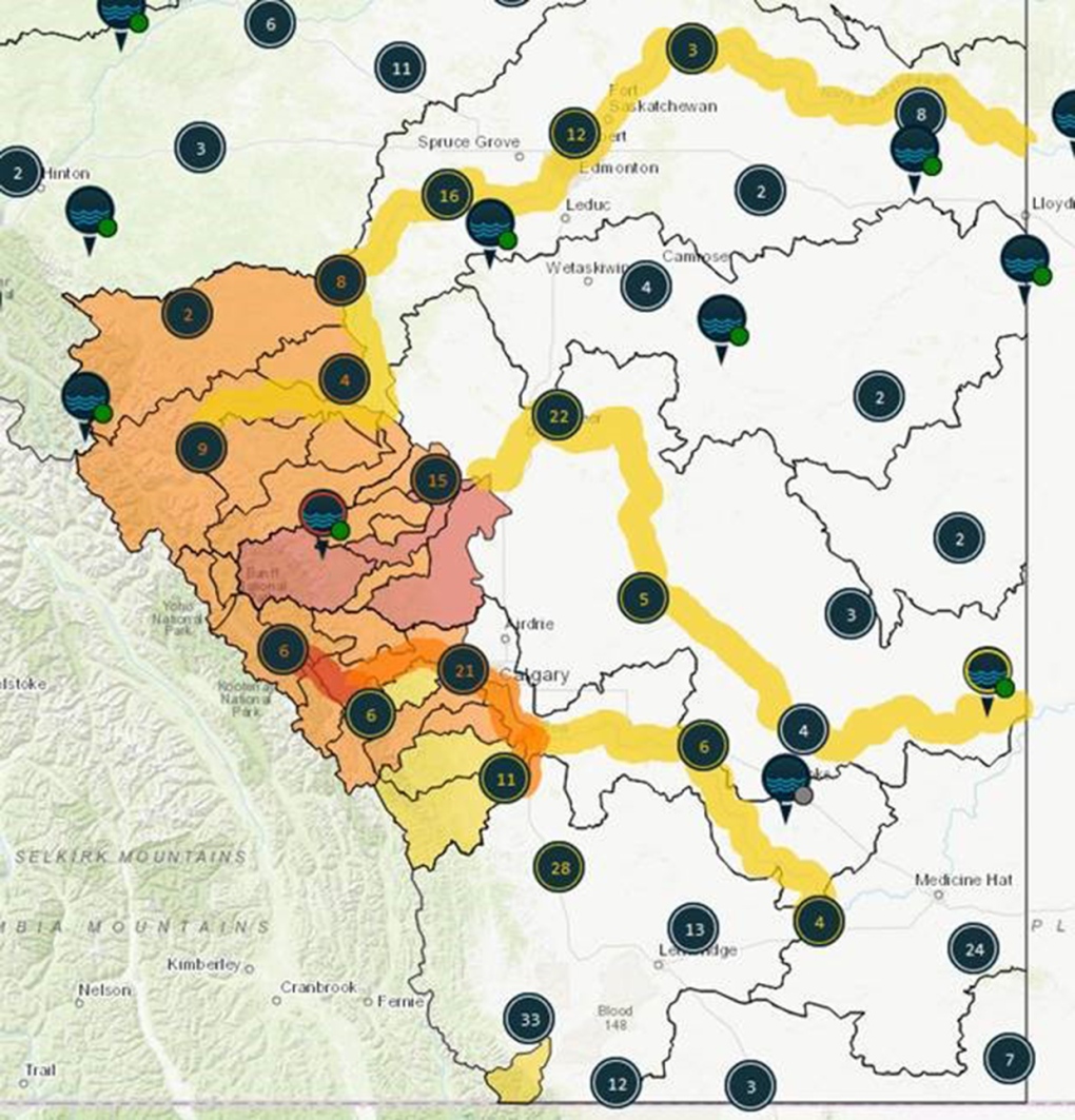
A flood warning is in place along the Bow River from Banff to Exshaw, newly upgraded as of last night; watches are also in place in a number of areas:
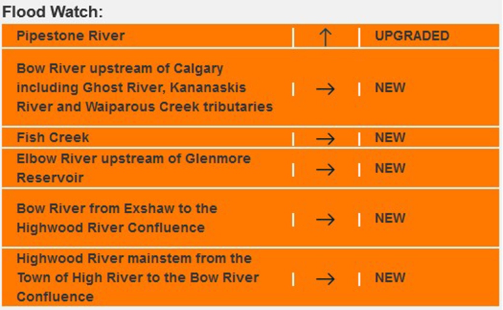
You can check this information here. With the possibility of one to two metre water level rises, significant impact is possible from this event.
To digress: isolated thundershowers will be a component of this rain band over Monday and Tuesday afternoons. Some areas are likely to receive flash flooding, as roadways and waterways may be incapable of dealing with the significant rain totals on the way.
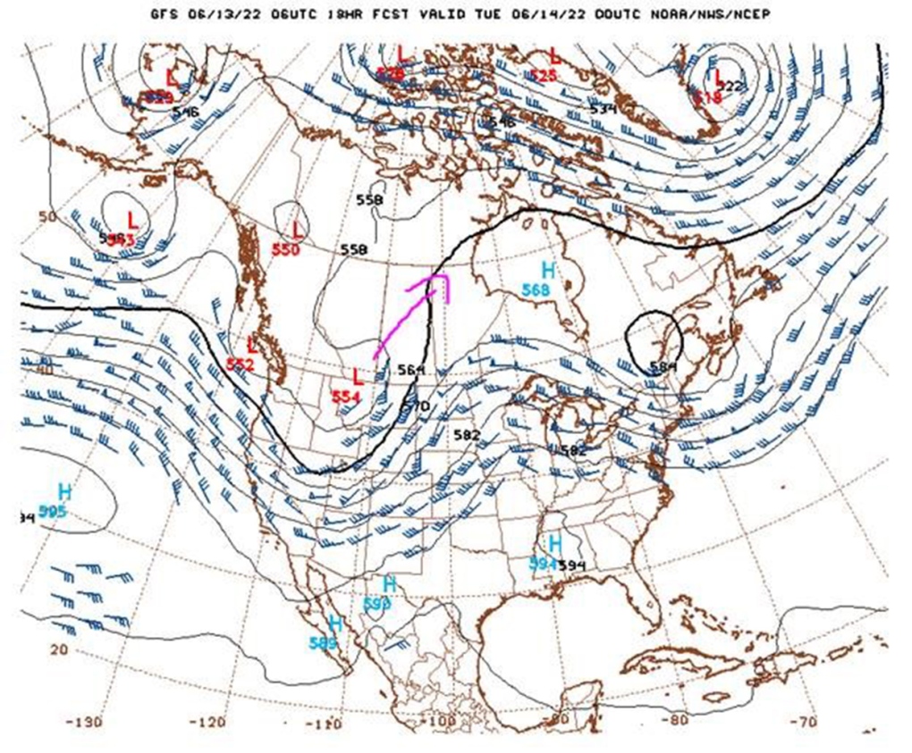
By Wednesday, this low will be pushing northeastward (fuschia arrow), which tapers the rain.
WHAT IT ISN'T
A mirrored, equally-significant and equally-scaled callback to 2013.
Adriana Zhang wrote a solid piece on this last night; additive to her notes on significant early-season rainfall (May 2013 received over 100 mm of rain, for instance, compared to 11.3 mm this year). This translated to additional soil moisture as a contributing rainfall factor, and enhanced waterway depths ahead of the significant rainfall they received that year.
This to say nothing of the work Calgary has done since then to mitigate future events.
Another pair of major factors – active runoff of mountain moisture has been ongoing for a while, now. The dry season and lack of significant rain-on-snow events in the Rockies, in spite of higher-than-usual snowpack, have made for natural and gradual declines in snow pillows. Here is the data from Little Elbow Mountain, scrabbled to a graph:
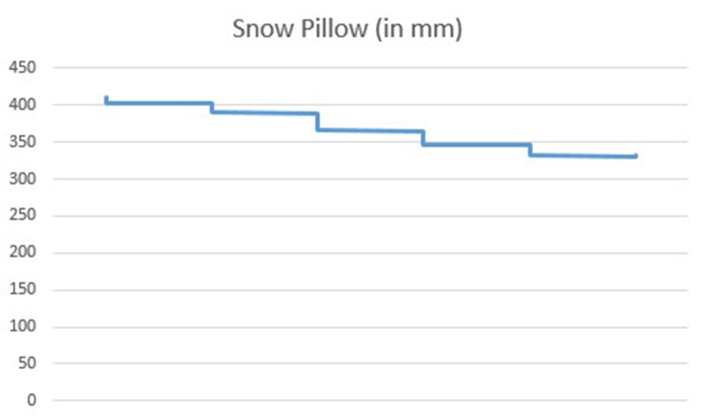
This represents a dataset from June 8 to the morning of June 13. I checked yesterday afternoon and this morning and cannot find the data, but recall seeing snow pillow amounts of up to 10,000 mm (10 metres!) from 2013 leading up to the floods.
The last element that I want to mention: the lack of a Rex Block. I've drawn on the same upper systems map as before with the pattern that presented in 2013; this created a feedback loop of moisture and enhanced upslope flow, triggering against a snow pillow largely untouched by conditions to that point in the year:
Before I checked Calgary's conditions, I checked Banff's. The consensus seems to be 60 to 80 mm, but that will range higher in the wake of some upslope patterning as the days wear on. After all, the flood warning in place isn't borne of nothing; enhanced rainshowers are still a strong likelihood.
We'll be updating as the day wears on. The Alberta weather Year in Review will almost certainly feature this very day. Stay safe.
YOUR FIVE-DAY CALGARY FORECAST
Monday
- Evening: showers, low 8 C
Tuesday
- Rain
- Daytime high: 11 C
- Evening: showers, low 9 C
Wednesday
- Morning showers, clearing
- Daytime high: 16 C
- Evening: mostly clear, low 7 C
Thursday
- Partly cloudy
- Daytime high: 17 C
- Evening: cloudy, chance of showers low 9 C
Friday
- Mainly cloudy, showers
- Daytime high: 21 C
- Evening: cloudy, chance of showers low 12 C
Saturday
- Showers
- Daytime high: 17 C
- Evening: clear, low 6 C
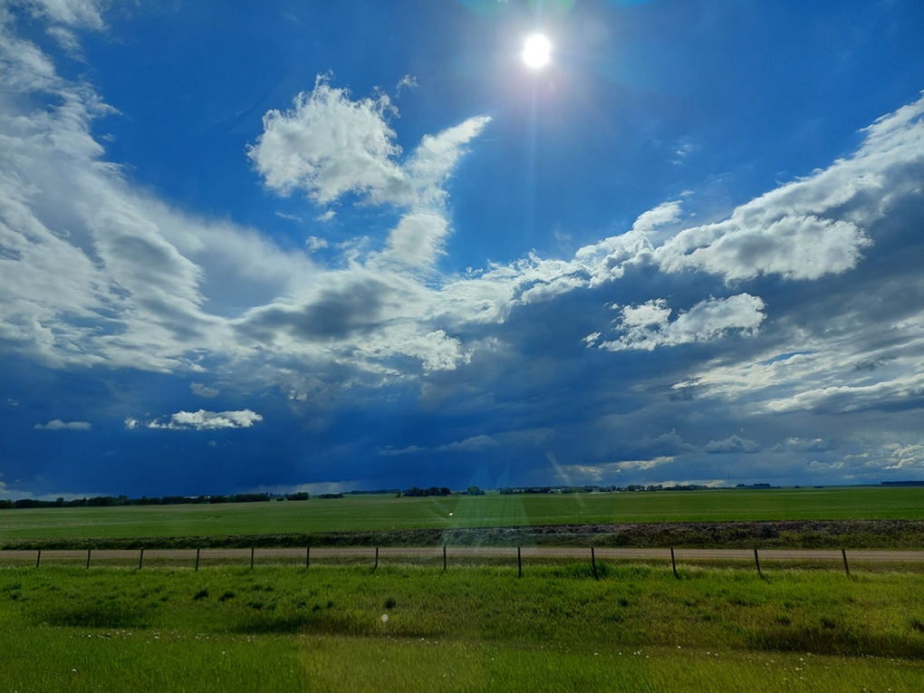
Today's pic was sent in by Jackie, following the tremendously photogenic storms from yesterday… from a distance.
Submit your weather photos here to see them featured in our article, and perhaps even as the pic of the day during our News at Six! You can also share my way on Twitter, or to our Instagram at @CTVCalgaryWeather.
Shopping Trends
The Shopping Trends team is independent of the journalists at CTV News. We may earn a commission when you use our links to shop. Read about us.


CTVNews.ca Top Stories

Bird flu, measles top 2025 concerns for Canada's chief public health officer
As we enter 2025, Dr. Theresa Tam has her eye on H5N1 bird flu, an emerging virus that had its first human case in Canada this year.
Azerbaijan observes day of mourning for air crash victims as speculation mount about its cause
Azerbaijan on Thursday observed a nationwide day of mourning for the victims of the plane crash that killed 38 people and left all 29 survivors injured as speculation mounted about a possible cause of the disaster that remained unknown.
Donald Trump says he urged Wayne Gretzky to run for prime minister in Christmas visit
U.S. president-elect Donald Trump says he told Canadian hockey legend Wayne Gretzky he should run for prime minister during a Christmas visit but adds that the athlete declined interest in politics.
Thousands without power on Christmas as winds, rain continue in B.C. coastal areas
Thousands of people in British Columbia are without power on Christmas Day as ongoing rainfall and strong winds collapse power lines, disrupt travel and toss around holiday decorations.
Prayers and tears mark 20 years since the Indian Ocean tsunami that killed some 230,000 people
People gathered in prayer and visited mass graves in Indonesia’s Aceh province on Thursday to mark 20 years since the massive Indian Ocean tsunami hit the region in one of modern history’s worst natural disasters.
New York taxi driver hits 6 pedestrians, 3 taken to hospital, police say
A taxicab hit six pedestrians in midtown Manhattan on Wednesday, police said, with three people — including a 9-year-old boy — transported to hospitals for their injuries.
Historical mysteries solved by science in 2024
This year, scientists were able to pull back the curtain on mysteries surrounding figures across history, both known and unknown, to reveal more about their unique stories.
Ho! Ho! HOLY that's cold! Montreal boogie boarder in Santa suit hits St. Lawrence waters
Montreal body surfer Carlos Hebert-Plante boogie boards all year round, and donned a Santa Claus suit to hit the water on Christmas Day in -14 degree Celsius weather.
Canadian activist accuses Hong Kong of meddling, but is proud of reward for arrest
A Vancouver-based activist is accusing Hong Kong authorities of meddling in Canada’s internal affairs after police in the Chinese territory issued a warrant for his arrest.
Edmonton
-

Alberta premier hopes for health reform payoff in 2025, regrets deferring tax cut
"It may have been better for Albertans if we'd implemented and then found a way to be able to pay for it."
-
Donald Trump says he urged Wayne Gretzky to run for prime minister in Christmas visit
U.S. president-elect Donald Trump says he told Canadian hockey legend Wayne Gretzky he should run for prime minister during a Christmas visit but adds that the athlete declined interest in politics.
-
Lake Louise ice climber takes a scary fall, then carries on climbing ice
The sport of ice climbing is becoming more and more popular, but one man is lucky to be alive after a serious fall in Alberta’s back country.
Lethbridge
-

Lake Louise ice climber takes a scary fall, then carries on climbing ice
The sport of ice climbing is becoming more and more popular, but one man is lucky to be alive after a serious fall in Alberta’s back country.
-
Safety tips for holiday home cooks: Lethbridge Fire and Emergency Services
If you’re planning to cook over the holidays, Lethbridge Fire and Emergency Services is reminding everyone to do it safely.
-
Here’s which bins your Christmas wrapping, ribbons and leftovers should go into
With piles of presents unwrapped Wednesday, Environment Lethbridge is reminding everyone to dispose of all that waste properly.
Vancouver
-

Thousands without power on Christmas as winds, rain continue in B.C. coastal areas
Thousands of people in British Columbia are without power on Christmas Day as ongoing rainfall and strong winds collapse power lines, disrupt travel and toss around holiday decorations.
-
Passenger dead following pickup truck crash in Surrey, B.C.
A section of B.C.’s Highway 15 has closed following a crash that killed a person Christmas Day.
-
Homegrown gift-giving initiative makes Christmas morning magic for families in need
On Christmas morning, hundreds of families throughout the Lower Mainland who otherwise might not have had anything to open were given sackfuls of brightly wrapped gifts to unwrap with their families, courtesy of a grassroots charity ran by one Surrey woman.
Vancouver Island
-
BC Ferries cancels many Christmas Day sailings, says others 'at risk'
The stormy weather in the forecast for B.C.'s South Coast is already disrupting many Christmas Day travel plans.
-
Janitors at Vancouver airport ratify deal with employer, end strike
The janitors who clean the Vancouver International Airport have ratified a new collective agreement with their employer, ending their strike on Christmas Eve.
-
Gas leaking after truck crash in Port Moody not ammonia, police say
There were tense moments for first responders in Port Moody on Christmas Eve, after a commercial truck crashed and began leaking gas.
Saskatoon
-

'People prop the doors open': Saskatoon resident concerned as people shelter in her stairwell
With the number of homeless people in Saskatoon at an unprecedented high, it’s no surprise people are looking for places to warm up.
-
Sask. highway closed following serious collision
The Saskatchewan RCMP are investigating a serious collision on Highway 7, approximately 15 kilometres west of Rosetown.
-
A separate Ukrainian Christmas may be a thing of the past
There might be more households than usual celebrating this Christmas Eve, as many Ukrainians around the world are opting to abandon the orthodox calendar.
Regina
-

Pedestrian collision sends man to hospital with life-threatening injuries
One man has been sent to hospital with life-threatening injuries after he was struck by a vehicle in the early hours of Wednesday in Regina.
-
Here's what's open and what's closed in Regina this holiday season
Here's what residents can expect in terms of city services as Regina slides right into the Christmas holidays.
-
This miniature village is a Christmas tradition for one Regina family
A miniature Christmas village made of decorative houses and buildings has been slowly growing in a Regina home.
Toronto
-

'A strong woman who never gave up': East Toronto neighbourhood shaken by death of unhoused resident
People in Toronto’s east end are shaken after a well-known unhoused woman from the community reportedly died over the weekend.
-
Man wanted for 2 unprovoked incidents in downtown Toronto on Christmas Eve
Toronto police are searching for a suspect who allegedly choked a female in downtown Toronto then threatened an employee at a business with a hammer.
-
1 person seriously injured in Scarborough stabbing
One person was taken to the hospital with serious, but non-life-threatening injuries following a stabbing on Dec. 25 in Scarborough, say paramedics.
Montreal
-
 WEATHER
WEATHER Smog warning in effect in Montreal, Laval
Residents of Montreal, Laval and other regions are advised that a smog warning is in effect.
-
Ho! Ho! HOLY that's cold! Montreal boogie boarder in Santa suit hits St. Lawrence waters
Montreal body surfer Carlos Hebert-Plante boogie boards all year round, and donned a Santa Claus suit to hit the water on Christmas Day in -14 degree Celsius weather.
-
What's happening in Montreal this weekend? Here's a guide
From PWHL action to Cirque du Soleil to a New Year's Eve slow dance, there is plenty going on during the final weekend of 2024 in Montreal.
Atlantic
-

Two deaths in Truro ruled homicides: RCMP
Police in Nova Scotia are investigating after two deaths in Truro, N.S., over the weekend have been ruled homicides.
-
Snow forecast through Christmas Eve for parts of the Maritimes
Parts of the Maritimes that were hit by a weekend snowstorm are in for more of the white stuff this Christmas Eve.
-
'Can I taste it?': Rare $55,000 bottle of spirits for sale in Moncton, N.B.
A rare bottle of Scotch whisky is for sale in downtown Moncton, N.B., with a price tag reading $55,000.
Winnipeg
-

'They gambled with trees': Cutting down trees resumes in Lemay Forest
The next chapter of the Lemay Forest saga has unfolded as the sounds of trees coming down could be heard Monday.
-
One person dead, another injured following Monday night house fire
One person has died and another is in unstable condition following a house fire Monday evening.
-
Winnipeg police investigating string of packages being stolen
The Winnipeg Police Service is investigating a string of package thefts in the Transcona area.
Ottawa
-

Ottawa G1 driver caught driving uninsured, unaccompanied with out-of-service plate on HWY 417
A G1 driver is facing multiple charges after being stopped on Highway 417 in Ottawa for out-of-service licence plate Wednesday, according to the Ontario Provincial Police (OPP).
-
YEAR-IN-REVIEW
YEAR-IN-REVIEW Top stories in Ottawa in 2024
It was a year of change in Ottawa in 2024, with federal public servants required to spend more time in the office, alcohol now available in grocery stores and gas stations, and the Ottawa Senators taking the next step towards moving downtown.
-
What's open and closed in Ottawa over the holidays
CTVNewsOttawa.ca takes a look at what's open and closed over the Christmas and New Year's holidays this year.
Northern Ontario
-

Indigenous family faced discrimination in North Bay, Ont., when they were kicked off transit bus
Ontario's Human Rights Tribunal has awarded members of an Indigenous family in North Bay $15,000 each after it ruled they were victims of discrimination.
-
Quebec suspect charged with stunt driving in northern Ont.
A 25-year-old from Notre Dame du Nord, Que., has been charged with stunt driving, police in Temiskaming said Tuesday.
-
Dismiss Trump taunts, expert says after 'churlish' social media posts about Canada
U.S. president-elect Donald Trump and those in his corner continue to send out strong messages about Canada.
Barrie
-

Here's when Santa is coming down your chimney, live tracking underway in Simcoe County
The spirit of Christmas is in the air as Santa Claus begins his lasting journey to deliver presents to children around the region.
-
Help this missing pup make it home for Christmas
The Ontario SPCA in Barrie needs your help bringing this handsome pup home to his family before Christmas.
-
Last minute shoppers braced for chaos but found calm on Christmas Eve
Many shoppers were out on Christmas Eve, and while the rush was expected to be chaotic, many found the day surprisingly manageable.
Kitchener
-

Feel-good stories of 2024: Dramatic dog rescue, Guelph toddler gets transplant and lost letters returned
Before we say goodbye to 2024, let’s look back at some of the good news stories we brought to you this year.
-
Why holiday shopping may feel a little different this year
At around 11 a.m. Tuesday at Kitchener’s Fairview Park Mall, there were plenty of parking spots available. It’s a sign that maybe this year, the rush for last minute gifts is no more.
-
How to stay safe during the holiday season
As fun festivities begin, the Canadian government, SickKids and fire departments in the Waterloo Region are reminding families of the higher safety risks during the holiday season.
London
-

Palace Theatre boarded up over the holidays due to recent damage
A break in, theft, and continued property damage has led to the boarding up of the Palace Theatre over the Christmas holidays.
-
Knights stars ready to help Canada chase gold at World Juniors
Three London Knights are on the roster, including Easton Cowan, who scored a hat-trick in Canada’s first exhibition game.
-
London fire responds to Wellington Road collision, contains fuel leak
London Fire Department was on the scene of a two vehicle collision involving a delivery truck on Tuesday morning.
Windsor
-

Mother-daughter duo pursuing university dreams at the same time
For one University of Windsor student, what is typically a chance to gain independence from her parents has become a chance to spend more time with her biggest cheerleader — her mom.
-
VIDEO
VIDEO From a repaired stuffed animal to an ATV, shoppers reveal the best gift they have ever received
We asked people of all ages getting in some last-minute Christmas Eve shopping inside Windsor’s Devonshire Mall to talk about the best present they've ever received — and their answers might just warm your heart this holiday season.
-
'We may have to look at other sensible locations': Where will Windsor’s new H4 be located?
The search for a site to house Windsor’s new Homelessness and Housing Help Hub (H4) is back underway after the city scrapped plans at 700 Wellington Avenue on Monday.


