BREAKING
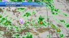
A snowfall warning issued for the foothills Wednesday was expanded to include the City of Calgary and areas north.
According to Environment and Climate Change Canada (ECCC) totals of 15 to 30 centimetres are possible over this multi-day snow event.
A low complex system situated over the Pacific Northwest will drive steady moisture into Alberta via the southern border in waves – with precipitation rates quite high at times.
 Caption: A snowfall warning (white) from ECCC, includes Calgary. (Thursday, April 4, 2024)
As expected the precipitation initially started as rain on Wednesday before transitioning to a rain-snow mix and finally heavy, wet snow around 4 a.m. Thursday.
Warmer surface temperatures on roads and sidewalks allowed most of that initial snow to melt on contact, however vehicles that were parked outside overnight had a build-up of slushy, wet snow.
A stronger north wind at the surface complicated matters by amplifying visibility issues, and by 8 a.m. area highways were starting to show some slushy accumulations, prompting 511 Alberta to evaluate highways west and south of Calgary as having winter driving conditions.
 With daytime highs expected to remain around freezing for most of the day Thursday and Friday and north winds remaining a factor for Thursday, untreated roads and sidewalks and vulnerable surfaces like corners, intersections, ramps and bridge decks will likely become slick.
With daytime highs expected to remain around freezing for most of the day Thursday and Friday and north winds remaining a factor for Thursday, untreated roads and sidewalks and vulnerable surfaces like corners, intersections, ramps and bridge decks will likely become slick.
Surfaces like wooden decks and patios and grass will also become slicker throughout the day.
 Areas in the southern foothills are likely to receive the highest accumulations due to an upsloping component – as counter clockwise rotation around the lows pushes moisture back up against the Rockies. And in some communities there will be brief periods of rain mixed in with snow.
There will be very little sunshine until at least Sunday, and daytime highs are expected to remain below seasonal until then.
Areas in the southern foothills are likely to receive the highest accumulations due to an upsloping component – as counter clockwise rotation around the lows pushes moisture back up against the Rockies.
In some communities there will be brief periods of rain mixed in with snow.
For the latest weather advisories from ECCC click here. 511 Alberta highway conditions can be found here, and click here for the latest on B.C. roads
 There will be very little sunshine until at least Sunday, and daytime highs are expected to remain below seasonal until then.

Veteran TSN broadcaster Darren 'Dutch' Dutchyshen, one of Canada’s best-known sports journalists, has died. He was 57.
A Montreal father who kidnapped his daughter who has autism and lied to police when they asked where she was should serve three years in prison, a Crown prosecutor said.
Many Canadians found a message from the Canada Revenue Agency this week as they received their first direct deposit for the Canada Carbon Rebate.
A medical examiner says a Massachusetts teen who participated in a spicy tortilla chip challenge died from ingesting a substance 'with a high capsaicin concentration.'
Auto technology has evolved and many newer cars use wireless key fobs and push-button starters instead of traditional metal keys. But that technology also makes things easier for thieves.
Scientists from the University of Western Australia and Kelpsie Geociences in the U.K. say they were surprised to discover an underwater camera caught video of a rare deep-sea squid.
Although a global workers' treaty has been in force in Canada since January, an employment lawyer believes it won't do anything more to protect employees from violence and harassment.
The Saskatchewan RCMP wants you to know it’s not targeting drive-thrus to ticket people for using their fast food reward apps.
The Slovak interior minister said Thursday that a 'lone wolf' has been charged in the shooting that seriously wounded Prime Minister Robert Fico.
The Shopping Trends team is independent of the journalists at CTV News. We may earn a commission when you use our links to shop. Read about us.
Government and fire officials will give an update on Alberta's wildfire situation Thursday morning. Watch both news conferences online at CTVNewsEdmonton.ca.
Veteran TSN broadcaster Darren 'Dutch' Dutchyshen, one of Canada’s best-known sports journalists, has died. He was 57.
Edmonton Oilers head coach Kris Knoblauch is undecided on who will be starting in net in Thursday night's Game 5 tilt against the Vancouver Canucks.

A school west of Lethbridge has shortened its weekly schedule for the new year, a move the board says offers more flexibility for its students and their families.
Each year, 15,000 students study at either the University of Lethbridge or Lethbridge College. Now, the City of Lethbridge is working to figure out how it can get more of those students to stay after graduation.
Frontline workers in the hospitality and tourism industry took a tour around main attractions in Lethbridge to get a better understanding of local offerings.
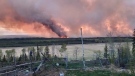
More than one home has been damaged or lost due to a massive wildfire outside of the B.C. community of Fort Nelson, the mayor confirmed Wednesday.
Travelling with a pet is already a challenge, but soon it could be even harder for dog owners heading down to the U.S.
An 'unrepentant' YouTuber has been ordered to pay $350,000 in damages as compensation for a 'relentless' campaign of defamation waged online against a business owner and his company, the B.C. Supreme Court has ruled.
More than one home has been damaged or lost due to a massive wildfire outside of the B.C. community of Fort Nelson, the mayor confirmed Wednesday.
A battle is brewing on the Saanich Peninsula after North Saanich council closed the only dedicated pickleball court in the area.
A Victoria driver has learned the meaning of the old adage 'you can't fight city hall' – especially when It comes to potholes.

The Saskatchewan RCMP wants you to know it’s not targeting drive-thrus to ticket people for using their fast food reward apps.
Rebecca Strong is Saskatchewan's newest millionaire after winning the grand prize on Canada's Got Talent.
Veteran TSN broadcaster Darren 'Dutch' Dutchyshen, one of Canada’s best-known sports journalists, has died. He was 57.
Members of Piapot First Nation, students from the University of Winnipeg and various other professionals are learning new techniques that will hopefully be used for ground searches of potential unmarked grave sites in the future.
The Moose Jaw Warriors are the 2024 Western Hockey League (WHL) Champions after defeating the Portland Winterhawks in four games.
Veteran TSN broadcaster Darren 'Dutch' Dutchyshen, one of Canada’s best-known sports journalists, has died. He was 57.

The details of a 16-month Durham police investigation into Ontario’s so-called ‘Crypto King’ Aiden Pleterski are set to be revealed on Thursday afternoon.
Railway cars loaded with sulphuric acid were not property secured by crew members when they derailed at the Canadian Pacific Railway Company’s Toronto Yard in Scarborough in 2022, according to a newly released report by the Transportation Safety Board of Canada.
Veteran TSN broadcaster Darren 'Dutch' Dutchyshen, one of Canada’s best-known sports journalists, has died. He was 57.

A Montreal father who kidnapped his daughter who has autism and lied to police when they asked where she was should serve three years in prison, a Crown prosecutor said.
Veteran TSN broadcaster Darren 'Dutch' Dutchyshen, one of Canada’s best-known sports journalists, has died. He was 57.
A Quebec man is seeking permission to file a class-action lawsuit against several car companies, claiming they are to blame for vehicle thefts due to security failures with their key fobs.

Two prominent Catholic churches in Halifax are permanently closing their doors.
Veteran TSN broadcaster Darren 'Dutch' Dutchyshen, one of Canada’s best-known sports journalists, has died. He was 57.
Lighting a fire during a daily burn ban in Nova Scotia will cost a pretty penny this summer.

The ex-wife of an admitted serial killer is expected to testify today in a Winnipeg courtroom.
Nearly six dozen dogs were seized from a home Wednesday morning by the Winnipeg Humane Society. It is the largest known seizure of animals in the city’s history.
Winnipeg police are investigating the suspicious death of a 35-year-old man earlier this month.

The Ottawa Fire Service says firefighters responded to a call for a fire on Tall Oak Private, near the Ottawa Hospital General Campus, at approximately 9:30 a.m.
Researchers at the University of Ottawa (uOttawa) say while recent research shows breast cancer cases are on the rise among younger Canadians (Link), early diagnosis not only saves lives, but also saves the country's healthcare system nearly $500 million.
Emergency crews responded to the crash involving a motorcycle and an SUV on Craig Street, west of Hamilton Road, in Russell at approximately 9:40 p.m. Wednesday.

One person is in custody while a second suspect is on the loose following a stabbing that sent two people to hospital in northern Ontario, police say.
Veteran TSN broadcaster Darren 'Dutch' Dutchyshen, one of Canada’s best-known sports journalists, has died. He was 57.
A Montreal father who kidnapped his daughter who has autism and lied to police when they asked where she was should serve three years in prison, a Crown prosecutor said.

Orillia's famous Christmas tree faces the wood chipper.
Work to extend Bryne Drive in Barrie's south end is ahead of schedule.
Loved ones of Tyler McCue, who died just before Christmas in 2022 while in custody at the Central North Correctional Centre, are speaking out, alleging he didn't receive the medical attention he needed.

The local humane society is asking for the public's help to care for five puppies that were found abandoned in a box near Hwy. 401 in Kitchener.
Veteran TSN broadcaster Darren 'Dutch' Dutchyshen, one of Canada’s best-known sports journalists, has died. He was 57.
A teenager has been seriously injured and another has been arrested after an alleged edged weapon assault in Cambridge.

An 18-year-old resident of Tillsonburg is facing charges after crashing into a school bus with students aboard in South-West Oxford early Thursday morning.
Oxford Street East has reopened after a fire broke out at an east end residence on Thursday morning.
An investigation is underway after two people were assaulted during separate incidents at St. Thomas high schools earlier this week.

It's been nearly eight months since a bench warrant was issued for the woman who Greg Marentette believes has possession of his Newfoundland dog — but no arrest has been made and Lemmy still has not been found.
Here’s a list of what’s open and closed in Windsor-Essex on Victoria Day on Monday, May 20, 2024.
Chatham-Kent police are investigating after a garage break-in in Wallaceburg.