Rain, snow, thunderstorm and tornado risk across Alberta for Thursday
Thursday will bring a wide variety of weather into Alberta.
In southern Alberta, instability will be enhanced as westerly flow across the Rockies encounters a dryline in southeastern Alberta.
This is likely to produce some localized intense thunderstorms and potentially a tornado east of Calgary and into southwesten Saskatchewan.
Calgary is likely to see isolated thunderstorms in the afternoon and evening, but outside of localized heavier accumulations the rainfall should total five to 10 millimetres throughout the 24-hour period.
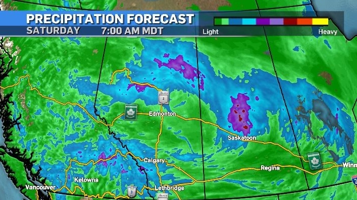
A series of low pressure systems will bring rain into northern Alberta with some models suggesting between 20 to 40 millimetres could fall over that region by Friday night. This will likely have a temporary positive impact on air quality in some communities, limiting the smoke to areas closer to source fires.

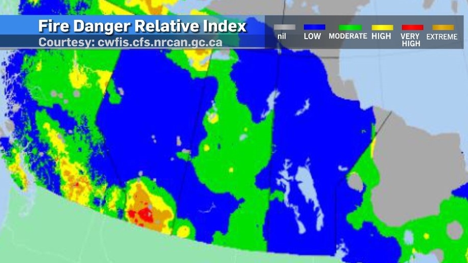
The fire danger relative index – an assessment which evaluates how easy it would be for a fire to start, how difficult it would be for a wildfire to be extinguished and the amount of damage a wildfire could produce - is showing low ratings in northern Alberta, something that has not happened for while.
Again, this is a relative index focusing on new fires and these ratings can change quickly – especially as the weather changes, but it is a small gain.
In southern Alberta, wind will be intense on Thursday in many communities and air masses interact, and temperatures will drop over the next few days. Snow is possible in higher elevations overnight throughout the weekend and advisories have been issued for higher elevation highways like Kootenay Pass in southern British Columbia.
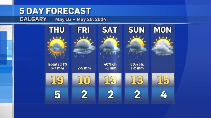
In Calgary, both the daytime highs and overnight lows will be below seasonal this weekend. Rain is expected Friday and likely to be scattered on Saturday and Sunday, with sunshine more prevalent on Monday.


CTVNews.ca Top Stories

Police release video of Toronto plaza shooting that killed university student
A university student from Brampton was killed when two shooters fired indiscriminately into a crowded plaza in Toronto last month in what police say was a 'cowardly act.'
'Hopeless and helpless': Regina mother seeks help to treat rare spinal disease
Mary Grace Rico is seeking help in getting treatment for a rare spinal condition.
The iPhone is getting a 'glow' up. What to expect from Apple's Monday event
Apple excited fans with its vision for its 'Apple Intelligence' artificial intelligence system earlier this year. Now, it's time for the company to prove it really works.
No more porta-potties at B.C. construction sites starting Oct. 1
What some B.C. construction workers describe as the worst aspect of their jobs will be coming to an end next month, the province announced.
Trump campaigns in Wisconsin just days ahead of debate with Harris
With just days to go before his first — and likely only — debate against U.S. Vice-President Kamala Harris, former U.S. president Donald Trump leaned into his familiar grievances about everything from his indictments to the border as he campaigned in one of the most deeply Republican swaths of battleground Wisconsin.
'Extremely vigorous' wildfire activity in central B.C. prompts crews to back off for safety
The wildfire fight in central B.C. intensified Friday, according to officials.
They were due to leave for their dream cruise in May. Three months on they’re still stuck at the departure port
It was the years-long cruise that was supposed to set sail, but saw its departure postponed… postponed… and postponed again.
Aryna Sabalenka beats Jessica Pegula to win the U.S. Open for her third Grand Slam title
Aryna Sabalenka got past Jessica Pegula 7-5, 7-5 in a rollicking U.S. Open women’s final Saturday to win her first championship at Flushing Meadows and third Grand Slam title of her career.
Shopping Trends
The Shopping Trends team is independent of the journalists at CTV News. We may earn a commission when you use our links to shop. Read about us.


Edmonton
-

1 dead, 1 injured after semi and SUV crash head-on near Sedgewick
A woman is dead and a man is in hospital after an SUV and a semi truck crashed on Highway 13 near Sedgewick on Friday.
-
Oiler Corey Perry gets assist during Friday Night Smackdown at Rogers Place
The Worm made a guest appearance on WWE's Smackdown at Rogers Place Friday night.
-
Jasper re-entry: Hotels get ready to house residents, recovery workers
Jasper’s hotels will play a key role in providing short-term housing for residents and recovery workers, but they first need a deep clean.
Lethbridge
-

Nicotine pouches scarce after federal ban restricts sales to pharmacy-only sales
It’s been just over a week since the federal government banned nicotine pouches from being sold anywhere other than a pharmacy.
-
City of Lethbridge releases more inclusive welcoming land acknowledgment
A more inclusive and welcoming land acknowledgment has been released by the City of Lethbridge.
-
Free stuff: Reuse Rendezvous returns to Lethbridge Saturday
Those looking to do some de-cluttering ahead of the fall can put their unwanted items on their front lawn for the annual Reuse Rendezvous this weekend.
Vancouver
-

Major BC Ferries vessel will be out of service for 6 months
One of the vessels that services the busy Tsawwassen-Swartz Bay route will be out of commission for about six months after its propeller fell off, according to BC Ferries.
-
Man carrying handgun and nearly $30K in cash arrested in Victoria, police say
Police in Victoria arrested a man they found in possession of a loaded handgun and more than $29,000 worth of cash earlier this week.
-
Fire destroys commercial greenhouse in Surrey
A large fire destroyed a greenhouse in Surrey early Saturday morning, causing "quite a spectacle," according to firefighters.
Vancouver Island
-
Major BC Ferries vessel will be out of service for 6 months
One of the vessels that services the busy Tsawwassen-Swartz Bay route will be out of commission for about six months after its propeller fell off, according to BC Ferries.
-
Man carrying handgun and nearly $30K in cash arrested in Victoria, police say
Police in Victoria arrested a man they found in possession of a loaded handgun and more than $29,000 worth of cash earlier this week.
-
'Extremely vigorous' wildfire activity in central B.C. prompts crews to back off for safety
The wildfire fight in central B.C. intensified Friday, according to officials.
Saskatoon
-

Winnipeg Blue Bombers down Saskatchewan Roughriders 26-21
The victory moved the Bombers into top spot in the CFL's West Division, while the Roughriders remain in third after failing to win for a seventh straight outing.
-
These two political parties in Saskatchewan are considering an alliance
Two political parties in Saskatchewan are considering a potential alliance ahead of the upcoming provincial election.
-
Teen girl charged with attempted murder after student set on fire at Saskatoon high school
A 14-year-old girl faces an attempted murder charge after a 15-year-old girl was doused in a flammable substance and set on fire at a Saskatoon high school Thursday.
Regina
-
Winnipeg Blue Bombers down Saskatchewan Roughriders 26-21
The victory moved the Bombers into top spot in the CFL's West Division, while the Roughriders remain in third after failing to win for a seventh straight outing.
-
'Hopeless and helpless': Regina mother seeks help to treat rare spinal disease
Mary Grace Rico is seeking help in getting treatment for a rare spinal condition.
-
These two political parties in Saskatchewan are considering an alliance
Two political parties in Saskatchewan are considering a potential alliance ahead of the upcoming provincial election.
Toronto
-
Police release video of Toronto plaza shooting that killed university student
A university student from Brampton was killed when two shooters fired indiscriminately into a crowded plaza in Toronto last month in what police say was a 'cowardly act.'
-
Fentanyl-laced gummies discovered in Hamilton: police
Hamilton Police are warning locals of the discovery of fentanyl-laced gummies 'disguised as candy,' after finding them during a recent warrant.
-
Driver ran red light before Whitby hit-and-run that left woman with critical injuries: police
A woman is in hospital in life-threatening condition after she was struck in a hit-and-run in Whitby early Saturday morning.
Montreal
-

Former NHLer and addict Brandon Reid's new goal is to help others beat addiction
Brandon Reid was a promising NHLer for the Vancouver Canucks, but his struggles with addiction almost killed him. He now trains other addicts as they fight to stay sober.
-
Teen killed on e-scooter near Montreal park honoured, calls for more safety measures
Family and community members gathered in Montreal's Cartierville neighbourhood on Saturday to pay respects to a 14-year-old boy who was killed while riding a scooter in the summer.
-
Petition calls for service dog subsidy for those with autism in Quebec
A petition has garnered more than 10,000 signatures calling for the Quebec subsidy for service dogs to be extended to those with autism.
Atlantic
-

N.S. RCMP issues formal apology to African Nova Scotians for historic use of street checks
The Nova Scotia RCMP has issued a formal apology to African Nova Scotians and people of African descent for the historic use of street checks and other harmful interactions.
-
Flooding repairs at Cape Breton Regional Hospital expected to take five months
The Nova Scotia Health Authority has released more information about the significant flooding at the Cape Breton Regional Hospital on August 25.
-
Here's what jobs will survive in the AI boom: Statistics Canada estimates
A recent study by Statistics Canada sheds light on how different occupations may be affected by the AI boom, including those who might lose their jobs in a more automation-driven future.
Winnipeg
-

Premier says Manitoba grand chief to lie in state at provincial legislature
Grand Chief Cathy Merrick of the Assembly of Manitoba Chiefs will lie in state at the provincial legislature following her sudden death.
-
Winnipeg Blue Bombers down Saskatchewan Roughriders 26-21
The Winnipeg Blue Bombers defeated the Saskatchewan Roughriders 26-21 on Saturday, marking the team's fifth-straight victory and fifth Banjo Bowl win in a row.
-
Corn maze craze: Where to get lost this fall
Corn maze season has officially begun throughout Manitoba – a sign that fall is just around the corner.
Ottawa
-

Here's what the latest rate cut means for mortgage holders, home buyers
The Bank of Canada has lowered its key interest rate by 25 basis points to 4.25 per cent.
-
Garage fire displaces two adults in Orleans
Ottawa Fire Services says two adults have been displaced following a fire that started in the garage of their home in Orleans Friday evening.
-
Ottawa canoeist Brianna Hennessy wins Paralympic silver medal
Canadian para canoeist Brianna Hennessy raced to her first Paralympic medal with a reminder of her mother on her paddle.
Northern Ontario
-

Despite union protest, new hybrid work rules for federal employees kick in Monday
Public service unions will start the week with an early-morning rally opposing the policy. But despite the unions' 'summer of discontent' and an ongoing court challenge, the new rules will still kick in on Sept. 9.
-
Sudbury OPP officer pleads guilty to stealing evidence during moose hunt investigation
A veteran staff sergeant with the Ontario Provincial Police in Sudbury has been sentenced for stealing two items from a First Nations man and hiding what he did while his fellow officers searched for them.
-
Fentanyl-laced gummies discovered in Hamilton: police
Hamilton Police are warning locals of the discovery of fentanyl-laced gummies 'disguised as candy,' after finding them during a recent warrant.
Barrie
-

3-car crash in Midland
Three vehicles were involved in a crash on Bayshore Drive near Frank Street in Midland on Saturday.
-
Alleged sexual assault under investigation
Officers from Southern Georgian OPP are investigating an alleged overnight sexual assault incident in Midland last weekend.
-
Parkinson's 'SuperWalk' raises more than $30K
The 35th annual Parkinson Canada 'SuperWalk' in Barrie on Saturday raised more than $30,000 to support Parkinson's Disease research.
Kitchener
-

Three teens charged for armed robbery at Kitchener jewelry store
Three teens were arrested for an armed robbery at a Kitchener jewelry store after witnesses caught and detained the suspects until officers arrived on scene.
-
'They just see these tenants as a profits': Guelph residents fighting back against renoviction
Guelph tenants worry they'll have find a new home after recently receiving N-13 notices from their new apartment owner.
-
Wheelchair basketball player from Fergus ends his Paralympic career
Patrick Anderson is heading home after his sixth – and final – Paralympic Games.
London
-

‘Proactive enforcement’: City of London housing blitz aims at helping tenants address issues with landlords
The City of London’s municipal enforcement team spent Saturday at 700 units on Kipps Lane, helping tenants address property standards issues.
-
Strathroy-Caradoc police searching for robbery, stabbing suspects
The Strathroy-Caradoc police are investigating a robbery and stabbing following an incident early Saturday morning.
-
Trial against former Woodstock mayor, Trevor Birtch, continues
The trial of former Woodstock mayor, Trevor Birtch, continued on Friday.
Windsor
-

Two knives said to be involved in Friday’s fatal police-involved shooting: SIU
The Special Investigations Unit’s (SIU) forensic investigators remain on scene Saturday afternoon following Friday’s fatal shooting involving a Windsor police officer.
-
VIDEO
VIDEO Has Walkerville become the 'new downtown' of Windsor? These residents say yes
Citing a vibrant business and dining scene, more active streets and a perception of greater safety, residents at a new event in Walkerville say the neighborhood has become Windsor's "new downtown," outshining the traditional core as the city's most desirable place to be — day or night.
-
Chatham-Kent police remind drivers to watch for deer
Chatham-Kent police are reminding drivers to watch for deer while out on the roads, especially at dusk and dawn.


