Wet, cold and snowy start to the week prompts weather warnings/statements
A low complex (multiple low-pressure systems) across the western Prairies and B.C. will create some challenging conditions over the next few days.
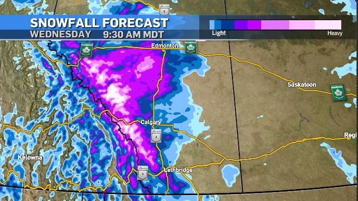
Southern Alberta will be impacted by multiple upsloping events, with the first hitting Monday afternoon and evening.
A colder air mass from the north will clash with a moisture-laden system from the Pacific producing heavy accumulations of precipitation.
These types of scenarios with systems that have counter-clockwise rotation and move over the mountains and across southern Alberta are very difficult to forecast with precision.
As such models calculating the location of the heaviest accumulations and the type of precipitation vary significantly, even from run-to-run using the same parameters and programs.
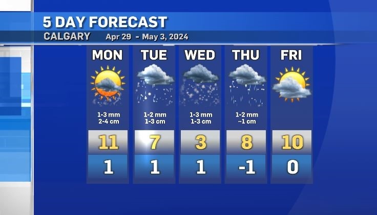
Rain will precede snow in most areas in the province as warmer atmospheric temperatures persist on Monday. The daytime highs in southern Alberta on Monday are expected to be in the low-double digits.
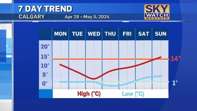
Temperatures will steadily decline as the week goes on with the daytime highs in Calgary expected to hit 3 C by Wednesday, which is 14 degrees below seasonal.
Overnight temperatures will remain closer to seasonal as the window between highs and lows narrows throughout the week.
It is likely that the heaviest amounts of snow on Monday and Tuesday will be west of Calgary as a low pressure system riding the southern border is expected to track east throughout the week, but again, confidence is low.
Initial snowfall is expected to melt off of roadways as surface temperatures remain elevated, but if snowfall rates are intense and/or winds are strong, (most likely to occur at higher elevations) that snow could pile up and impact traction.
Once snow does start to accumulate there is the potential for areas to rapidly add to that total. Some models are suggesting snowfall amounts of 20 to 30 centimetres are possible in the Rockies in less than a day.
Hail is possible in the foothills and portions of the Rockies Monday due to the convective potential at the beginning of this event.
A second round of snow will impact the region late Tuesday and again on Wednesday. Normal diurnal cycles will dictate that this precipitation should coincide with the coldest times of the day, so a rain/snow mix or snow will be most probable as the week goes on.


CTVNews.ca Top Stories
'Some structural damage' from wildfire near Fort Nelson, B.C., mayor confirms
More than one home has been damaged or lost due to a massive wildfire outside of the B.C. community of Fort Nelson, the mayor confirmed Wednesday.
'Very expensive lunch': Sask. driver says he got a cellphone ticket for using his points app in the drive-thru
A warning from a Saskatoon driver about using your fast-food app while in the drive-thru line — a trip to get some free lunch cost him a lot more than he bargained for.
B.C. YouTuber ordered to pay $350K for 'relentless' online defamation campaign
An 'unrepentant' YouTuber has been ordered to pay $350,000 in damages as compensation for a 'relentless' campaign of defamation waged online against a business owner and his company, the B.C. Supreme Court has ruled.
Chief says grave search at B.C. residential school brings things 'full circle'
Chief Robert Michell says relief isn't the right word to describe his reaction as the search begins for unmarked graves at the site of a former residential school he attended in northern British Columbia.
'Endless Shrimp' just one misstep for Red Lobster as it eyes bankruptcy protection
While it's unclear what these closures might mean for the 27 restaurants in Canada, Red Lobster is expected to file for bankruptcy protection in the U.S. this month.
B.C. man shot sex worker in the back during drug-fuelled birthday, court hears
A man from B.C.'s Lower Mainland has been sentenced to four years behind bars after shooting a sex worker in the back during a drug-fuelled 43rd birthday.
'Inhumane conditions': 68 dogs pulled from Winnipeg home
Nearly six dozen dogs were seized from a home Wednesday morning by the Winnipeg Humane Society. It is the largest known seizure of animals in the city’s history.
Ontario's 'Crypto King' Aiden Pleterski arrested
Of the $40-million Aiden Pleterski was handed over two years, documents show he invested just over one per cent and instead spent $15.9 million on "his personal lifestyle." The 25-year-old Oshawa, Ont. man was arrested and charged with fraud and money laundering on Tuesday.
Driver said he smoked pot oil, took medication before Florida crash that killed 8 Mexican workers
A man with a long record of dangerous driving told investigators he smoked marijuana oil and took prescription drugs hours before he sideswiped a bus, killing eight Mexican farmworkers and injuring dozens more, according to an arrest report unsealed Wednesday.
Shopping Trends
The Shopping Trends team is independent of the journalists at CTV News. We may earn a commission when you use our links to shop. Read about us.


Edmonton
-

Edmonton family 'heartbroken' police officer evades charges in 2021 killing of unarmed man
An Edmonton police officer won't face charges for killing an unarmed man in 2021, despite Alberta's police watchdog finding evidence that an offence was committed.
-
Winds expected to move fire away from Fort McMurray on Wednesday: province
A wildfire burning near Fort McMurray is expected to move away from the community on Wednesday.
-
Oilers coach undecided which goalie will start Game 5 against Canucks
Edmonton Oilers head coach Kris Knoblauch is undecided on who will be starting in net in Thursday night's Game 5 tilt against the Vancouver Canucks.
Lethbridge
-

City of Lethbridge working to keep post-secondary graduates local
Each year, 15,000 students study at either the University of Lethbridge or Lethbridge College. Now, the City of Lethbridge is working to figure out how it can get more of those students to stay after graduation.
-
Visitor information providers gain local tourism knowledge through interactive bus tour
Frontline workers in the hospitality and tourism industry took a tour around main attractions in Lethbridge to get a better understanding of local offerings.
-
Lethbridge calls first year of encampment strategy a success
While they may not be noticeable to residents, the City of Lethbridge is making a few changes to its encampment strategy to help connect the city’s vulnerable population with services and support.
Vancouver
-
'Some structural damage' from wildfire near Fort Nelson, B.C., mayor confirms
More than one home has been damaged or lost due to a massive wildfire outside of the B.C. community of Fort Nelson, the mayor confirmed Wednesday.
-
Former B.C. premiers join in calls for a right-of-centre party merger
A seismic shift could be coming to the B.C. political landscape as backroom talks to strike a deal between the province's two right-of-centre parties are underway.
-
Fans in Latvia watching Canucks games at 4 a.m. to see national hero Silovs
The legend of Arturs Silovs seems to grow every game – whether he’s staring down Connor McDavid or Leon Draisaitl with the game on the line, or joking about it after.
Vancouver Island
-
'Some structural damage' from wildfire near Fort Nelson, B.C., mayor confirms
More than one home has been damaged or lost due to a massive wildfire outside of the B.C. community of Fort Nelson, the mayor confirmed Wednesday.
-
B.C. tribunal rules city not liable for vehicle damaged by pothole
A Victoria driver has learned the meaning of the old adage 'you can't fight city hall' – especially when It comes to potholes.
-
Pickleballers eye noise-reduction measures after North Saanich expulsion
A battle is brewing on the Saanich Peninsula after North Saanich council closed the only dedicated pickleball court in the area.
Saskatoon
-

Sask. singer Rebecca Strong wins $1M, Canada's Got Talent
Rebecca Strong is Saskatchewan's newest millionaire after winning the grand prize on Canada's Got Talent.
-
Saskatoon nurses call code blue over emergency room crowding
Nurses at Saskatoon's Royal University Hospital are once again warning the public of dangerous overcrowding inside one of Saskatchewan's busiest hospitals.
-
Saskatoon pastor turned council hopeful disputes status of shelter
Robert Pearce, a local pastor who plans on running for city council, believes the homeless shelter in Fairhaven violates zoning bylaws.
Regina
-

Regina Sexual Assault Centre opens new 'trauma informed' location
The Regina and Sexual Assault Centre (RSAC) has recently moved locations and its new space was designed with its purpose in mind.
-
As Sask. teachers vote on new sanctions mandate, education minister, STF say bargaining is restarting
Negotiations between the provincial government and Saskatchewan Teachers’ Federation (STF) will be restarting on Wednesday, according to the province’s education minister.
-
Over 40 projects across Sask. recognized for sustainable development achievements
On Wednesday, over 40 projects across Saskatchewan were recognized for their efforts of Achievement in Education for Sustainable Development.
Toronto
-
 GARDINER GRIDLOCK
GARDINER GRIDLOCK 'Needs to be done faster': Calls grow for construction to pick up the pace
In the final report of a three-part series on Gardiner Gridlock, CTV Toronto asks what more can be done to alleviate the impact of the construction that has been a tipping point for Toronto traffic.
-
Ontario's 'Crypto King' Aiden Pleterski arrested
Of the $40-million Aiden Pleterski was handed over two years, documents show he invested just over one per cent and instead spent $15.9 million on "his personal lifestyle." The 25-year-old Oshawa, Ont. man was arrested and charged with fraud and money laundering on Tuesday.
-
The list of attractions offering free admission to Toronto library card holders just got longer. What to know
The list of attractions and venues in Toronto that offer free admission to millions of eligible participants has expanded as part of a new collaboration between two of the city's iconic institutions.
Montreal
-

Quebec court rejects McGill injunction request to remove encampment
A Quebec judge has rejected McGill University's request for an injunction to remove the pro-Palestinian encampment on the university's campus in downtown Montreal.
-
Woman, 34, found dead in Ormstown with stab wounds; man arrested
A 60-year-old man has been arrested after a woman's body was found with stab wounds in a home southwest of Montreal, Quebec provincial police say.
-
Man arrested 10 years after Longueuil bike path murder
A 35-year-old man has been arrested in connection with a decade-old murder case.
Atlantic
-

Two Catholic churches in Halifax are permanently closing their doors
Two prominent Catholic churches in Halifax are permanently closing their doors.
-
Halifax police searching for man missing from hospital
Halifax Regional Police, along with Ground Search and Rescue crews, are in the area of Dalhousie University Wednesday night searching for a man missing from a Halifax hospital.
-
Fire officials on edge as Nova Scotia dries up
With wildfire conditions worsening in Nova Scotia, efforts are underway to inform those living in encampments about potential hazards
Winnipeg
-

'Inhumane conditions': 68 dogs pulled from Winnipeg home
Nearly six dozen dogs were seized from a home Wednesday morning by the Winnipeg Humane Society. It is the largest known seizure of animals in the city’s history.
-
Admitted serial killer Jeremy Skibicki was at Winnipeg homeless shelter to ‘stalk his victims,’ witness testifies
A worker at a homeless shelter in Winnipeg says he met admitted serial killer Jeremy Skibicki who told him he was at the shelter to stalk his victims.
-
Arrest made after Winnipeg grocery store employees assaulted with brass knuckles: WPS
Police say a teenager is facing charges after three employees at a Winnipeg grocery store were assaulted with brass knuckles.
Ottawa
-

Ottawa-Carleton District School Board looks to integrate more special needs kids into general classroom
It could mark the biggest change in 25 years, as the Ottawa-Carleton District School Board looks to overhaul its elementary programs, a decision that could integrate more special needs students into the general classroom.
-
Ottawa community leader and businessman Larry Bradley passes away
Larry Bradley, a well-known community leader and Ottawa businessman, has died at the age of 74.
-
Tougher impaired driving consequences on the way in Ontario
The Ontario government is bringing in tougher penalties as it looks to stem the alarming rise in the number of drivers getting behind the wheel drunk or high, sometimes with deadly consequences.
Northern Ontario
-

'Very expensive lunch': Sask. driver says he got a cellphone ticket for using his points app in the drive-thru
A warning from a Saskatoon driver about using your fast-food app while in the drive-thru line — a trip to get some free lunch cost him a lot more than he bargained for.
-
Tazed and bitten in the face: Sudbury police dealt with some wild cases last month
The monthly police services board in Greater Sudbury gives the public insight into the day-to-day operations of police, including some of the cases they deal with far from the spotlight.
-
Victim loses $2M in online romance scam
A Malahide Township resident is out more than $2 million following a romance scam.
Barrie
-

Barrie city council approves waterfront field development
With the chambers packed for a second week in a row, Barrie city councillors made a momentous vote on a new plan for the waterfront that has dividing many residents throughout the city.
-
Construction on Barrie road extension in south end ahead of schedule
Work to extend Bryne Drive in Barrie's south end is ahead of schedule.
-
Loved ones seek justice for inmate's death in Penetanguishene jail
Loved ones of Tyler McCue, who died just before Christmas in 2022 while in custody at the Central North Correctional Centre, are speaking out, alleging he didn't receive the medical attention he needed.
Kitchener
-

New study shows financial impact of homelessness on our health-care system
A new study out of London, Ont. lays out the cost of the homelessness crisis on our health-care system.
-
Former teacher, trustees voice opposition to revised WRDSB bylaws
Carolyn Burjoski was a delegate at the Waterloo Region District School board meeting on Monday night – the former teacher’s first time addressing trustees since her controversial 2022 appearance.
-
Immigration Minister Marc Miller weighs in on local international student enrollment
Marc Miller dropped by the CTV Kitchener studio to comment on international student enrollment in post secondary schools.
London
-
 PLAYOFF TRACKER
PLAYOFF TRACKER London Knights sweep Oshawa Generals, win 5th OHL Championship
The London Knights have won their fifth OHL title after sweeping the Oshawa Generals in the league’s championship series.
-
'There is somebody in there!': Man pulled from burning Old East London apartment
Life-saving efforts were performed on a man taken from a burning loft apartment in London, Ont. Wednesday evening.
-
Dog dies in central London, Ont. fire
London fire crews dealt with an intense afternoon fire, but say all occupants made it out safe.
Windsor
-

Owner of missing dog 'can’t sleep' 8 months after warrant was issued for woman who took Lemmy
It's been nearly eight months since a bench warrant was issued for the woman who Greg Marentette believes has possession of his Newfoundland dog — but no arrest has been made and Lemmy still has not been found.
-
Sinkhole causes detours in Sandwich
Transit Windsor says a sinkhole is causing detours in Sandwich Town.
-
Windsor police pilot local tech on bicycle fleet
The Windsor Police Service (WPS) is deploying police on bicycles decked out with technology supplied by a local company.


