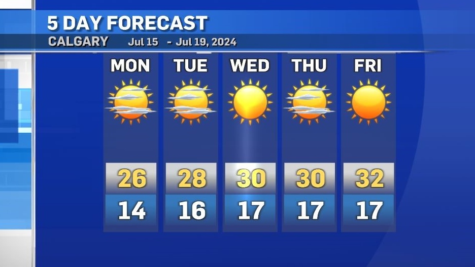
Monday's high of 26 C, the coolest high for at least a week
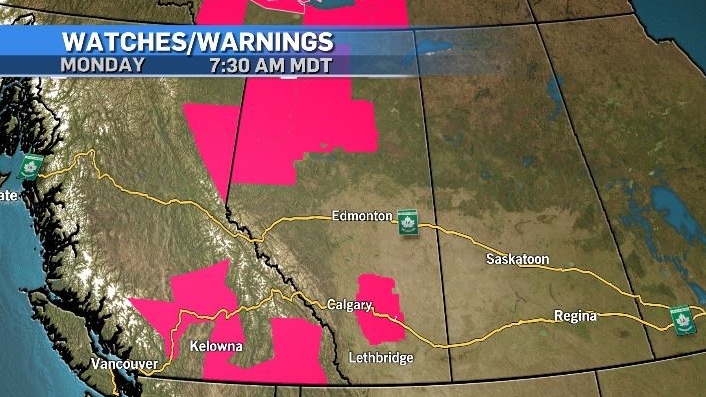
Heat warnings are expected to expand in the west as a prolonged heat event starts to set up across the Prairies.
As of Monday morning, heat warnings had been issued from Environment and Climate Change Canada for portions of southern and northern British Columbia, the Northwest Territories, northern Alberta and areas east of Calgary.
Heat warnings are issued for most of Alberta (excluding the southernmost communities like Medicine Hat, Pincher Creek and Lethbridge) when daytime highs reach a temperature of at least 29 C combined with a daytime low temperature of at least 14 C for at least two consecutive days.
Both daytime high and low temperatures will be above seasonal in Calgary and much of Alberta on Monday. Those temperatures are expected to continue to rise over the next few days.
In Calgary, Monday’s high of 26 C is three degrees above average, but it is also the coolest temperature expected for at least a week.
The synoptic setup will include an Omega block – a northerly riding, clockwise circulating high pressure system that is anchored at the base on either side by counter-clockwise circulating low pressure systems.
These types of blocking patterns can be very difficult to dislodge and can last for a prolonged period of time (a perfect example is the record-shattering Pacific heat dome event from 2021).
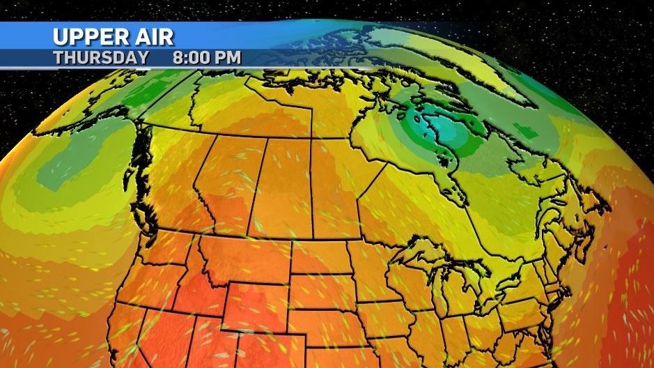
Before this pattern is firmly established there is a risk of convective activity on Monday and Tuesday across central and southern Alberta.
The combination of rapid daytime heating along with instability may prompt thunderstorms to fire off the foothills – all the way from Hinton to areas east of Crowsnest Pass.
If those storms do develop, they are expecting to track east fairly quickly, possibly impacting locations along the QEII and Highway 2 corridor including Calgary, Red Deer and Lethbridge.
Shopping Trends
The Shopping Trends team is independent of the journalists at CTV News. We may earn a commission when you use our links to shop. Read about us.


CTVNews.ca Top Stories

BREAKING
BREAKING N.S. Progressive Conservatives win second majority government; NDP to form opposition
For the second time in a row, Tim Houston's Progressive Conservatives have won a majority government in Nova Scotia. But this time, the NDP will form the official opposition.
Paul Bernardo denied parole after victims' families plead he be kept behind bars
Notorious killer and rapist Paul Bernardo has been denied parole for a third time after the families of his victims made an emotional plea to the Parole Board of Canada on Tuesday to keep him behind bars.
'We would likely go out of business': Canadian business owners sound the alarm over Trump's tariffs
Business leaders across Canada are voicing concerns and fear over the widespread impact increased tariffs could have on their companies and workers, with some already looking to boost sales in other markets in the event their products become too expensive to sell to American customers.
Israel-Hezbollah ceasefire takes effect
A ceasefire between Israel and Iran-backed group Hezbollah took effect on Wednesday after U.S. President Joe Biden said both sides accepted an agreement brokered by the United States and France.
Longtime member of Edmonton theatre community dies during 'A Christmas Carol' performance
Edmonton's theatre community is in mourning after an actor died during a performance of "A Christmas Carol" at the Citadel Theatre on Sunday.
'We need to address those issues': Alberta Premier Danielle Smith won't denounce Trump tariff threat
Alberta Premier Danielle Smith says Canada should address U.S. president-elect Donald Trump's border concerns in the next two months, before he's back in the White House, instead of comparing our situation to Mexico's and arguing the tariff threats are unjustified.
Loonie tanks after Trump threatens tariffs on Canadian goods
The Canadian dollar fell to its lowest level since May 2020 after Donald Trump threatened to impose tariffs on Canadian goods shipped to the United States once he takes office in January.
Should Canada retaliate if Trump makes good on 25 per cent tariff threat?
After U.S. president-elect Donald Trump threatened to impose a 25 per cent tariff on all Canadian imports on his first day back in the White House unless his border concerns are addressed, there is mixed reaction on whether Canada should retaliate.
'We need to do better': Canadian leaders respond to Trump's border concerns
As U.S. president-elect Donald Trump threatens Canada with major tariffs, sounding alarms over the number of people and drugs illegally crossing into America, Conservative Leader Pierre Poilievre and some premiers say they agree that more could be done.
Edmonton
-

RCMP investigate death of MMA fighter in bout on Alberta First Nation
Police are investigating the death of a man at a mixed-martial arts fight Saturday on the Enoch First Nation adjacent to Edmonton.
-
Alberta takes aim at emissions cap, proposes rules on trespass and data gathering
Alberta Premier Danielle Smith says her government is eyeing a number of steps to challenge the proposed federal greenhouse gas emissions cap.
-
Fans, charity score in photo-op with Santa Claus and Oilers star at West Edmonton Mall
One Edmonton Oilers star was ho-ho-holding off on playing hockey Tuesday night at the city's biggest mall to help out with photos for charity.
Lethbridge
-

Lethbridge & District Exhibition short millions of dollars, unclaimed management expenses: report
Unclaimed management expenses, unsupported strategic plan targets and inconsistent project budgets are believed to be leading factors behind the Lethbridge & District Exhibition's (LDE) financial troubles, according to a newly released report.
-
'Let's do this': Crowsnest Pass mayor wants proposed coal mine sooner than later
A mayor in southwestern Alberta is hoping for an immediate meeting with Premier Danielle Smith to discuss a coal project his community has voted in favour of being built.
-
Alberta NDP concerned postal strike plan could hinder upcoming byelection
Alberta's Opposition NDP says a decision not to mail out voter registration cards due to the Canada Post strike could hurt turnout in a provincial byelection that is set for a week before Christmas.
Vancouver
-

'It's intimidation': Vancouver councillors told to stop displaying children's artwork during meeting
Two Vancouver city councillors were told to remove children's artwork from their desks during Tuesday's meeting, after one of their colleagues called the display of the drawings "intimidating."
-
Vancouver school trustees feud over public access at meetings
There were tense scenes at a Vancouver School Board meeting Monday night – with two trustees claiming there is a culture of secrecy.
-
Premiers plan meeting with PM, scramble to respond to Trump's tariff threats
Donald Trump's threat to slap 25 per cent tariffs on all Canadian goods imported into the United States has created major waves.
Vancouver Island
-

Public help sought in search for missing man with dementia
The family of a 64-year-old man with dementia is pleading with the public to help, urging a close look at pictures of their loved one – as a search for him extends into its fourth day.
-
BC Ferries changing direction on how it receives community feedback
BC Ferries says it’s changing route on how it receives feedback from the public.
-
B.C. court levies $4K fine, year-long ban for illegal fishing
A British Columbia man was handed a $4,000 fine and a one-year fishing ban after he was caught using a gillnet to illegally catch salmon.
Saskatoon
-

Saskatoon man hospitalized after he was allegedly stabbed in the forehead
A man has been taken to hospital after he was allegedly stabbed in the forehead early on Tuesday.
-
The Riche stuff: Off-season addition enjoying early success with Saskatoon Blades
The Saskatoon Blades were back in action Tuesday after a rare day off due to the snow Monday.
-
Affordability and tariffs dominate talk as legislature resumes in Saskatchewan
Day two of an exceptionally short fall sitting of the Saskatchewan legislature has now wrapped. An opposition motion to cut the provincial gas tax was struck down while the government faced criticism on more than half a dozen portfolios.
Regina
-

Charged dropped against ex Regina high school teacher accused of sexual exploitation of student
A former Regina high school teacher accused of having a sexual relationship with a 15-year-old female student was acquitted on Tuesday of all five charges he faced, Regina’s Court of King’s Bench confirmed to CTV News.
-
Affordability and tariffs dominate talk as legislature resumes in Saskatchewan
Day two of an exceptionally short fall sitting of the Saskatchewan legislature has now wrapped. An opposition motion to cut the provincial gas tax was struck down while the government faced criticism on more than half a dozen portfolios.
-
SJHL game postponed in Weyburn over ammonia leak
A hockey game scheduled between the Yorkton Terriers and Weyburn Red Wings has been postponed due to a "mechanical issue."
Toronto
-

Ford says Trump's proposed 25 per cent tariff on Canadian goods like 'a family member stabbing you right in the heart'
Ontario Premier Doug Ford says a 25 per cent tariff on all Canadian goods proposed by U.S. president-elect Donald Trump is akin to 'a family member stabbing you right in the heart.'
-
Serial killer Paul Bernardo denied parole for a third time: Key moments from today's hearing
Notorious killer Paul Bernardo has been denied parole for a third time following a hearing before the Parole Board of Canada.
-
Wanted suspect shot at passing vehicles on Highway 401 in Mississauga: OPP
Ontario Provincial Police are looking for a man who they say shot at several vehicles on Highway 401 in Mississauga Tuesday morning.
Montreal
-

Cinemas Guzzo closing West Island theatre amid major financial troubles
Cinemas Guzzo owner and reality TV star Vincenzo (Vince) Guzzo said he will close the Cinema Des Sources location as he faces financial trouble and fights to save his business.
-
21-year-old man shot in Rosemont apartment
A 21-year-old man was shot in the upper body following a suspected break-in, said Montreal police.
-
Quebec Premier says Trump's immigration concerns 'are legitimate'
Premier François Legault said he agrees with Donald Trump on immigration, but fears the devastating impact of the 25 per cent tariffs announced by the president-elect on Quebec exports.
Atlantic
-
BREAKING
BREAKING N.S. Progressive Conservatives win second majority government; NDP to form opposition
For the second time in a row, Tim Houston's Progressive Conservatives have won a majority government in Nova Scotia. But this time, the NDP will form the official opposition.
-
'Human error' and high traffic cause snafus on election day in Nova Scotia
Tuesday was election day in Nova Scotia, but not everything went according to plan. Elections Nova Scotia says “human error” is to blame for a delayed opening at one polling station and high traffic caused its website to crash.
-
N.S. NDP leader says they are the alternative after official opposition win
Claudia Chender wasn’t able to bring the Nova Scotia NDP fully back to power on Tuesday night, but her electoral victories restored the party to its strongest position in a decade and made provincial history in the process.
Winnipeg
-

Premier Kinew says Trump's tariffs would cause a recession in Manitoba
Tariffs on Canadian goods headed to the United States would mean a recession in Manitoba. That is how Manitoba Premier Wab Kinew feels about comments from president-elect Donald Trump Monday.
-
Winnipeg exploring shatterproof glass for bus shelters as city struggles with repairs
As Winnipeg struggles to keep up with repairs to bus shelters with broken glass, the city is looking to test shatterproof glass in hopes that will save time and money down the road.
-
Walking for love: 100-year-old Winnipeg man continues to make trek to visit his wife
It's considered lucky to live to be 100, but often when you hit that milestone, you're faced with significant mobility issues. Not Winnipeg's Jack Mudry. The centenarian regularly walks five blocks to get where he wants to go, the care home where his wife Stella lives.
Ottawa
-

O-Train Line 2 and 4 opening pushed into December at the earliest
The head of Ottawa's transit service says we will learn more about the launch of O-Train Line 2 and 4 next week, as the north-south light rail line remains closed to passengers.
-
'It's insulting:' Ontario premier slams Trump on Canadian tariff threat
Ontario Premier Doug Ford is reacting to a threat from incoming U.S. president-elect Donald Trump to impose tariffs on imports from Canada, calling the proposal ‘insulting’ and emphasizing the need for leaders to work together on a response.
-
Questions regarding photo radar tickets in Ottawa amid postal workers' strike
As the ongoing Canada Post workers' strike continues to shut down mail delivery, there are questions about those photo radar tickets issued on Ottawa streets and what it means for speeders.
Northern Ontario
-

Police seize $1M in drugs in northwestern Ont. bust
Suspects from Alberta and B.C. are in custody after Ontario Provincial Police made a massive drug bust at a rental unit near Kenora, Ont.
-
Sudbury resident scammed out of $20K, suspect from southern Ont. charged
A 21-year-old from southern Ontario has been charged with several offences after a victim from Greater Sudbury was tricked into giving him $20,000.
-
Loitering causing safety concerns by fire station in downtown Sudbury
There is enhanced security outside the main fire hall in downtown Sudbury in response to safety concerns.
Barrie
-

One person seriously injured in collision with dump truck
Emergency crews attended the scene of a serious collision between a dump truck and a minivan in Clearview Township.
-
OPP investigating assault on municipal law enforcement officer
Provincial police are investigating after a municipal law enforcement officer was allegedly assaulted by a group of individuals.
-
Local businesses brace for Trump's tariff threats
A threat of tariffs from U.S. President-elect Donald Trump has Canadians who do business south of border now keeping a close eye on his next moves.
Kitchener
-

Guelph man pleads guilty to leaving scene of crash that killed cyclist
A Guelph man has pleaded guilty to leaving the scene of a crash that resulted in the death of a cyclist and community advocate.
-
NHLer and former Kitchener Rangers staff member race to game on foot
Snow couldn't stop a Minnesota Wild hockey player from making it to his NHL debut, thanks to a little help from a former staff member of the Kitchener Rangers.
-
Paul Bernardo denied parole after victims' families plead he be kept behind bars
Notorious killer and rapist Paul Bernardo has been denied parole for a third time after the families of his victims made an emotional plea to the Parole Board of Canada on Tuesday to keep him behind bars.
London
-

Police look to identify 3 suspects in shooting investigation, arrest 4th suspect
London police are asking the public for help identifying suspects involved in a break, enter and shooting investigation.
-
Sarnia councillor won't apologize to mayor and staff for vulgar attacks during meeting
A controversial Sarnia councillor is under fire for a vulgar exchange during a city budget meeting on Tuesday.
-
The potential impact of Trump's tariff plans on St. Thomas EV factory
President-elect Donald Trump dropped a bombshell on Truth Social on Monday evening – stating “as one of my many first Executive Orders, I will sign all necessary documents to charge Mexico and Canada a 25% Tariff.”
Windsor
-

Downtown Mission concerned over ongoing Canada Post strike and donations tied up in negotiations
Officials at The Downtown Mission in Windsor are growing concerned about the amount of donations coming in since the strike at Canada Post began earlier this month.
-
Two suspects wanted for pharmacy break-in
Windsor police are searching for two suspects after a break-in at a pharmacy on Tecumseh Road East.
-
Lakeshore man facing more sex assault charges after second alleged victim comes forward
Essex County OPP say a Lakeshore man is facing more sexual assault charges after a second alleged victim has come forward.


