Strong wind, lightning possible as warm weather moves in
An incoming ridge of high pressure will usher in another run of above-seasonal temperatures to southern Alberta.
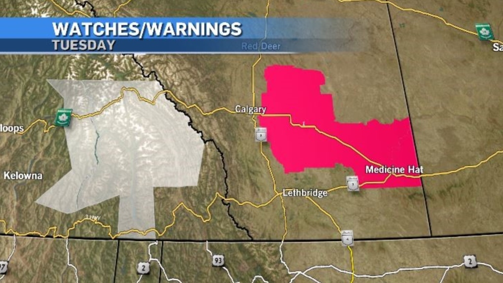
As of 6:30 p.m. on Tuesday, heat warnings were contained to areas south and east of Calgary but are expected to be expanded over the coming days.
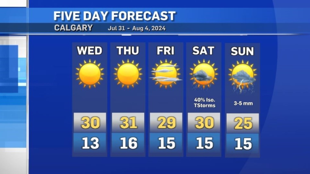
Instability is expected to peak Wednesday along the northern edge of that high (near the Capital region).
Strong wind, lightning and large-sized hail are all potential threats if these fast-moving and intense storms do develop.

Conditions are expected to stabilize in southern Alberta for the next few days with daytime highs and overnight lows forecast to reach the threshold criteria for a heat warning from Environment and Climate Change Canada.
This heat event is not expected to be as intense, nor will it last quite as long as the last one.
By Saturday, that ridge will start to break down and scattered thunderstorms are possible in the Calgary area Saturday evening until early next week.


CTVNews.ca Top Stories

Bloc Quebecois ready to extract gains for Quebec in exchange for supporting Liberals
The Bloc Québécois says its ready to wheel and deal with Prime Minister Justin Trudeau's party for support during confidence votes now that the Liberal government's confidence and supply agreement with the NDP has ended.
Over 200 firearms seized in weapons investigation: Waterloo Regional Police
According to police, during a traffic stop in Waterloo, officers noticed firearms and ammunition inside the vehicle.
'It's morally wrong': A rural Alberta town reacts to homeless shelter closure
At the end of a side street in Slave Lake, Alta., Lynn Bowes looks at a grey job-site trailer with boarded-up windows and doors that once operated as her town's only homeless shelter.
Trump threatens to jail adversaries in escalating rhetoric ahead of pivotal debate
With just days to go before his first and likely only debate against U.S. Vice-President Kamala Harris, former U.S. president Donald Trump posted a warning on his social media site threatening to jail those “involved in unscrupulous behavior” this election, which he said would be under intense scrutiny.
Dog mauled to death in B.C. yard after 3 pit bulls jump fence: police
A 12-year-old collie was killed by three pit bulls in the B.C. Interior Sunday morning, according to authorities.
Military surplus store in Calgary, destination of celebrity shoppers, closing doors
Cher, Anthony Hopkins, Heath Ledger, Alec Baldwin and Tom Hardy are just a few of the celebrities John Cumming met while growing up in his family's military surplus store.
Slide over salsa: K-pop takes socialist Cuba by storm
Socialist Cuba, the birthplace of salsa and other rhythms that have conquered the world, is now surrendering to the invasion of South Korean pop music.
Timeline: The rise and fall of Prime Minister Justin Trudeau's political fortunes
In the wake of the NDP withdrawing its automatic support of the minority Liberal government, here is a timeline of key events charting the arc of Prime Minister Justin Trudeau's fortunes in federal politics.
Jannik Sinner beats Taylor Fritz in U.S. Open men's final, weeks after failed doping test
Jannik Sinner beat Taylor Fritz 6-3, 6-4, 7-5 with a relentless baseline game to win the U.S. Open men’s championship on Sunday, less than three weeks after being exonerated in a doping case.
Shopping Trends
The Shopping Trends team is independent of the journalists at CTV News. We may earn a commission when you use our links to shop. Read about us.


Edmonton
-

'It's morally wrong': A rural Alberta town reacts to homeless shelter closure
At the end of a side street in Slave Lake, Alta., Lynn Bowes looks at a grey job-site trailer with boarded-up windows and doors that once operated as her town's only homeless shelter.
-
'Beautiful in its own way': New forest emerges in Jasper National Park, bringing protection and new opportunities
Charred stumps and the remains of fire-ravaged trees still cover large tracts of land on the Jasper landscape, but life is returning quickly down below.
-
RCMP seek missing hiker in northern Alberta
Mounties are searching for a man who went missing on a hiking trail west of Grande Prairie on Saturday.
Lethbridge
-

Rob Miyashiro earns NDP nomination for Lethbridge-West
Rob Miyashiro was selected as the NDP candidate in Lethbridge-West Saturday to replace MLA Shannon Phillips.
-
Nicotine pouches scarce after federal ban restricts sales to pharmacy-only sales
It’s been just over a week since the federal government banned nicotine pouches from being sold anywhere other than a pharmacy.
-
City of Lethbridge releases more inclusive welcoming land acknowledgment
A more inclusive and welcoming land acknowledgment has been released by the City of Lethbridge.
Vancouver
-

Dog mauled to death in B.C. yard after 3 pit bulls jump fence: police
A 12-year-old collie was killed by three pit bulls in the B.C. Interior Sunday morning, according to authorities.
-
Woman unconscious in hospital after being stabbed: Surrey RCMP
A woman is in hospital in serious condition after she was stabbed in Surrey’s Whalley area early Sunday, Mounties have confirmed.
-
B.C. First Nation offers reward for information in missing woman case
Mounties in Northern B.C. have set up a dedicated tip line as part of their ongoing investigation into the disappearance of an Indigenous woman two months ago.
Vancouver Island
-
Dog mauled to death in B.C. yard after 3 pit bulls jump fence: police
A 12-year-old collie was killed by three pit bulls in the B.C. Interior Sunday morning, according to authorities.
-
B.C. First Nation offers reward for information in missing woman case
Mounties in Northern B.C. have set up a dedicated tip line as part of their ongoing investigation into the disappearance of an Indigenous woman two months ago.
-
B.C.'s Bennett, Ont.'s Hennessy named flag-bearers for Paralympic closing ceremonies in Paris
Swimmer Nicholas Bennett and para canoeist Brianna Hennessy have been named Canada's flag-bearers for Sunday's closing ceremonies of the Paralympic Games in Paris.
Saskatoon
-

Saskatoon Public Schools offers counselling support after student set on fire at high school
In the wake of the tragic incident of setting a student on fire at Evan Hardy Collegiate, Saskatoon Public Schools announced that it is providing counselling services to students and staff affected by the event.
-
Winnipeg Blue Bombers down Saskatchewan Roughriders 26-21
The victory moved the Bombers into top spot in the CFL's West Division, while the Roughriders remain in third after failing to win for a seventh straight outing.
-
'Its a signature event': Broadway street fair returns to Saskatoon
Broadway avenue was alive with the bustle of Saskatoon residents enjoying their weekend. The street was closed off and turned into a pedestrian walkway for a massive street festival that saw thousands of participants.
Regina
-

Regina fire crews report no injuries after apartment fire
An investigation is underway after a fire broke out at a residential apartment building in Regina’s Rosemont-Mount Royal neighbourhood.
-
Mural showcasing diversity and youth unveiled in North Central community
The North Central Community Association has partnered with the Rainbow Youth Centre on a new mural in the heart of North Central.
-
'Sacredness': Medicine wheel in healing garden dedicated to local elder
A local elder was honoured at Westminster United Church on Saturday by having a medicine wheel dedicated to her.
Toronto
-
 BREAKING
BREAKING 1 person killed, 2 others injured in Brampton collision
One person has died following a head-on crash in Brampton late Sunday morning.
-
Toronto police locate missing 11-year-old girl
Toronto police say they have now located a missing 11-year-old girl who was last seen in North York late Saturday afternoon.
-
Texts, social media a 'minefield' for people going through divorce: lawyer
When Sarah Boulby tells clients going through a divorce or locked in a custody battle that their texts and social media posts might be put under a microscope, she usually gets one of two responses.
Montreal
-

Teachers say immigrants not to blame as Quebec links teacher shortage to newcomers
As Quebec politicians continue to point to immigration -- a common justification for the province's ills -- as the main culprit for the province's teacher shortage, education experts say newcomers are not the underlying cause of the widespread teacher shortages.
-
CTV News Montreal at Six for Sunday, September 8, 2024
Watch the CTV News Montreal broadcast at Six for Sunday, September 8, 2024 with anchor Matt Grillo.
-
Oka residents preparing checkpoint operations to stop illegal dumping in Kanesatake
Residents in Oka, Que. are preparing to take matters into their own hands to try to prvent the illegal dumping of contaminated material in the Kanien'kehá:ka (Mohawk) community of Kanesatake.
Atlantic
-

Residents of new affordable housing in Dartmouth begin moving in
The first residents of the 32 new affordable homes for women and their children in Dartmouth, N.S., have moved in, with more to follow in the coming weeks.
-
37-year-old woman dies following collision in Allardville: N.B. RCMP
A 37-year-old woman from Bathurst, N.B., has died following a two-vehicle collision in Allardville, N.B.
-
Children’s books unveiled in Whitney Pier as part of N.S. Polish Heritage Month
Bookstores often come with a table full of recommended reads, and it was no different at St. Mary's Polish Parish in Whitney Pier, N.S., on Sunday.
Winnipeg
-

Wanted man arrested after improvised gun found during traffic stop
A 23-year-old Winnipeg man is facing charges after he was found in possession of a loaded zip gun during a traffic stop by police.
-
Winnipeg firefighters battle 2 overnight blazes
Winnipeg Fire Paramedic Service crews were called to two fires early Sunday morning in the city’s William Whyte and St. John’s neighbourhoods.
-
New basketball court unveiled in Winnipeg’s Waverley neighbourhood
Those living in the city’s Waverley area will have a chance to shoot some hoops at a new outdoor basketball court at Bridgwater Park.
Ottawa
-
 WATCH AT 6 P.M.
WATCH AT 6 P.M. Here's how you can watch CTV News at Six on Sundays during the NFL season
With CTV broadcasting NFL football games on Sundays this season, CTV News at Six with Austin Lee will be broadcasting live on our website and the CTV News App.
-
Mayor Mark Sutcliffe defends his 'Fairness for Ottawa' campaign
Ottawa Mayor's "Fairness for Ottawa" campaign continues, as the city seeks more funding from all levels of government.
-
Hazmat contains fuel leak on Highway 417 near Bayshore mall
Ottawa Fire Services says its Hazmat team has successfully contained a fuel leak that was coming from a transport truck on Highway 417 near Bayshore mall Sunday afternoon.
Northern Ontario
-

Over 200 firearms seized in weapons investigation: Waterloo Regional Police
According to police, during a traffic stop in Waterloo, officers noticed firearms and ammunition inside the vehicle.
-
VIDEO
VIDEO Snow has returned to northeastern Ont.
As fall quickly approaches, leaves have begun to change colours and temperatures have started to dip in northeastern Ontario – perhaps starting to bring unwelcome wintry weather.
-
Canadian drivers enjoying unusual low gas prices for time of year
Drivers across the country are keeping more money in their pockets after filling up a tank of gas.
Barrie
-

CKVR alumni reunite
Familiar faces were brought back together as more than a hundred CKVR alumni gathered at Donaleigh's Irish Public House Saturday night for a special reunion.
-
Fire burns Blue Mountains chalet
A Saturday evening fire in the Town of the Blue Mountains caused significant damage at a residential chalet near the ski resort.
-
Overnight fire at controversial Berczy Park
Fire crews responded to a fire at Berczy Park in Barrie early Sunday morning, where a group of people using the area as a campground received a three-day eviction notice from the City earlier this week.
Kitchener
-
Over 200 firearms seized in weapons investigation: Waterloo Regional Police
According to police, during a traffic stop in Waterloo, officers noticed firearms and ammunition inside the vehicle.
-
Grieving mother planning peaceful protest at Rockwood OPP station
Faye Dzikewich continues to fight for answers for her 36-year-old son, who died after spending the night in an Ontario Provincial Police cell in Rockwood, Ont.
-
3 taken to hospital, 1 suffers life-threatening injuries following serious collision in Hagersville
One person was airlifted to hospital by Air Ornge with life-threatening injuries. Two other people were transported by ambulance with serious but non-life-threatening injuries.
London
-
 video
videovideo ‘Not checking out yet’: Woman with incurable cancer vows to keep fighting
Heather Appleton just renewed her passport for another ten years. “I’m not checking out yet,” said Appleton, 61, who has the incurable cancer, Multiple Myeloma.
-
Pedestrian dragged by vehicle
Owen Sound police are searching for witnesses after a pedestrian was dragged by a vehicle.
-
Arrests made in Sarnia break and enter investigation
Sarnia police officers have arrested two suspects after a break and enter investigation.
Windsor
-

One dead following collision on Lauzon Parkway and Lauzon Line
One person has died following a collision Saturday night.
-
Fire crews investigating blaze at former Windsor school
Windsor fire was on scene of a blaze at a former school on Norman Road Sunday afternoon.
-
Pillette Road closed for active investigation
The Windsor police said Pillette Road is closed from Grand Marais to Plymouth due to an active investigation.


