Warm weather comes to an abrupt end Monday night
A mild Sunday night leads into a warm start to the work week, but don’t let that deceive you. Winter storm conditions expected for much of the province, starting in northern regions Monday morning.
That snow moves into central Alberta by the afternoon, coupled with a cold front swinging through the province, bringing gusty winds and plummeting temperatures.
Wind gusts across central and southern regions could reach 70-90 km/h by Monday evening, causing blowing snow, poor visibility, and road conditions.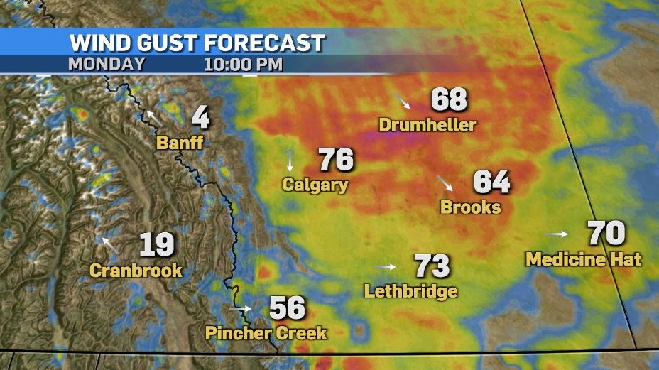
Snow tapers off through Tuesday morning as wind speeds diminish. Generally, 5-10 cm is expected across central and southern Alberta, but the foothills may see greater totals.
The cold settles in Tuesday, with temperatures slightly moderating mid-week before warm weather returns in the second half of the week.
Here’s the five day:
Monday:
- Sunny in the morning, increasing cloudiness late afternoon
- Daytime high: 9 C
- Overnight: Temperatures plummet, winds gust to 70 km/h, blowing snow, low -16 C, wind chill -25
Tuesday:
- Chance of early morning flurries, partly cloudy after that
- Daytime high: -13 C
- Overnight: Clearing, -22 C
Wednesday:
- Mostly sunny
- Daytime high: -9 C
- Overnight: Becoming mostly cloudy, -12 C
Thursday:
- Becoming mostly cloudy
- Daytime high: 4 C
- Overnight: Partly cloudy, -2 C
Friday:
- Clearing
- Daytime high: 2 C
- Overnight: Clearing, -1 C


CTVNews.ca Top Stories

Scottie Scheffler arrested at PGA Championship for traffic violation, returns to course hours later
Masters champion Scottie Scheffler was arrested Friday morning on his way to the PGA Championship, with stunning images showing him handcuffed as he was taken to jail for not following police orders during a pedestrian fatality investigation.
NEW
NEW What a wildfire survivor says she regrets not grabbing before leaving home
Carol Christian had 15 minutes to evacuate her home during the Fort McMurray wildfires in 2016. She ended up losing the house and everything inside. Now, she wants to share the lessons she learned.
Ontario sees first measles death in more than a decade after young child dies
A young child has died of measles in Ontario, marking the first death in the province from the highly contagious virus in more than 10 years, a Public Health Ontario report confirms.
Think twice before sharing 'heartbreaking' social media posts, RCMP warn
Mounties in B.C. are urging people to think twice before sharing "heartbreaking posts" on social media.
One way Canadians are shrinking rising grocery bills
As the cost of food in Canada has risen, grocery shoppers are looking at ways to reduce their grocery bill, and more are choosing price over beauty, turning to companies that deliver so-called 'misfit' produce at a fraction of the cost.
Vatican revamps norms to evaluate visions of Mary as it adapts to internet age and combats hoaxers
The Vatican on Friday radically reformed its process for evaluating alleged visions of the Virgin Mary, weeping statues and other seemingly supernatural phenomena, insisting on having the final say in whether the events are worthy of popular devotion.
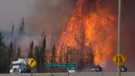
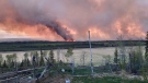
Wildfires are dampening against cool, rainy weather, but there's plenty left to contain
An opportune system of cool, wet weather Friday is dampening the spread of wildfires across Western Canada, but there's still plenty of work for responders and residents alike.
Jessica Biel hopes to normalize the conversation around menstruation with a new children's book
Jessica Biel is the author of a new children’s book focused on destigmatizing and normalizing the conversation around menstruation.
5 secrets to moving better and preventing avoidable injury
Countless people seek emergency care for back pain, muscle strains and similar injuries resulting from 'moving wrong' during mundane, everyday tasks such as bending over to tie shoes, lifting objects or doing household chores.
Shopping Trends
The Shopping Trends team is independent of the journalists at CTV News. We may earn a commission when you use our links to shop. Read about us.


Edmonton
-

Fort McMurray evacuees in Edmonton say they've been forced to spend hundreds on hotels, supplies
Some Fort McMurray evacuees say they're struggling to access supplies and accommodations after leaving their homes and travelling to Edmonton.
-
Wildfires cast smoky shadow over tourism industry ahead of unofficial start of summer
At Andrew Lake Lodge — a remote camp in the extreme northeast corner of Alberta — owner Dan Wettlaufer is looking forward to welcoming the first of this year's crop of tourists this weekend.
-
Four 1970s homicides linked to serial killer, Alberta Mounties to reveal Friday
A dead serial sexual offender and killer has been linked to four homicides in the 1970s in Alberta, RCMP say.
Lethbridge
-

Downtown Lethbridge lawlessness task force seeing positive progress
Lethbridge has been working to address lawlessness in the city’s downtown over the past six months.
-
Patios and parklets program returns to downtown Lethbridge for 2024
It's just about patio season in Lethbridge, and the city is once again rolling out its annual patios and parklets program.
-
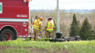
'Wanting everybody to feel comfortable and welcome': Alberta couple killed in highway crash remembered
Family and friends are mourning the loss of an Alberta couple who were killed Sunday in a highway crash northwest of Lethbridge, Alta.
Vancouver
-
Crews fighting wildfires near Fort Nelson, B.C, hope skies open up again after rainy Thursday
A rainy Thursday in and around Fort Nelson was exactly what fire crews were looking for.
-
B.C. Ferries anticipates busy travel day ahead of long weekend
The Victoria Day long weekend is expected to be busy for travellers, according to B.C. Ferries.
-
Miller scores late as Canucks grind out 3-2 win over Oilers in Game 5
J.T. Miller scored in the final minute of the game and the Vancouver Canucks came back for a 3-2 victory over the Edmonton Oilers in Game 5 of their second-round playoff series Thursday.
Vancouver Island
-

B.C. Ferries anticipates busy travel day ahead of long weekend
The Victoria Day long weekend is expected to be busy for travellers, according to B.C. Ferries.
-
B.C. boaters ordered to remove drainage plugs to prevent spread of whirling disease
British Columbia's chief veterinarian has issued an order making it illegal to transport boats or other watercraft without removing the drain plug to prevent the spread of whirling disease.
-
Miller scores late as Canucks grind out 3-2 win over Oilers in Game 5
J.T. Miller scored in the final minute of the game and the Vancouver Canucks came back for a 3-2 victory over the Edmonton Oilers in Game 5 of their second-round playoff series Thursday.
Saskatoon
-

Sask. teachers vote to renew mandate for job sanctions
Saskatchewan teachers have voted heavily in favour of a new mandate that allows job action to continue until an agreement with the province is reached.
-
Saskatoon blind, deaf water skier ready to make waves at world championships
A Saskatoon water skier who is blind and deaf has partnered with a well-known artist to fundraise for the national adaptive water ski team.
-
Saskatoon is losing one of its Giant Tiger discount stores
Giant Tiger has announced that the company is closing a number of stores including one location in Saskatoon.
Regina
-

Saskatchewan RCMP asking for help in identifying human remains found near Moose Jaw
Saskatchewan RCMP are asking for the public's help in identifying human remains discovered in a wooded area near Moose Jaw.
-
Sask. teachers vote to renew mandate for job sanctions
Saskatchewan teachers have voted heavily in favour of a new mandate that allows job action to continue until an agreement with the province is reached.
-
Police issue Canada-wide warrant for Regina homicide suspect
Police have issued a Canada-wide warrant for a man wanted in a homicide which occurred in Regina on May 12.
Toronto
-

Ontario sees first measles death in more than a decade after young child dies
A young child has died of measles in Ontario, marking the first death in the province from the highly contagious virus in more than 10 years, a Public Health Ontario report confirms.
-
Toronto couple finds love at Holland Bloorview Kids Rehabilitation Hospital
Midtown Toronto residents Will and Elizabeth Gossaert turned heads when they recently strolled through the halls of Toronto’s Holland Bloorview Kids Rehabilitation Hospital.
-
What's open and closed in Toronto on Victoria Day
The unofficial start of summer is upon us. If you still haven't made plans for Victoria Day, here’s what’s open and closed around Toronto on Monday.
Montreal
-

Palliative care isn't just for the dying: Demystifying what it means to get help
Palliative care, which is offered when someone is diagnosed with a serious illness, often gets confused with hospice care, which is comfort without curative intent.
-
Summer heat moving into Montreal for May long weekend
Temperatures are expected to be above average the entire weekend, and the daytime high on Monday could be close to the 30-degree mark.
-
Father charged with second-degree murder in daughter's stabbing death
A father has been charged with second-degree murder in the stabbing death of his 34-year-old daughter in southern Quebec.
Atlantic
-

Transport truck drives off overpass in Lower Sackville, N.S., landing on highway below
Traffic came to a halt Thursday afternoon when a truck drove off an overpass along a Halifax-area highway.
-
Video showing teen altercation in Fredericton sparks police investigation, calls for change
A video of a fight between two teens is being investigated by Fredericton police.
-
Maritime gas prices fall ahead of long weekend
The price of gas decreased overnight in all three Maritimes provinces ahead of the Victoria Day long weekend.
Winnipeg
-

Heavy rain, toonie-sized hail hammer parts of Manitoba
A severe thunderstorm rolled through parts of Manitoba on Thursday evening, producing heavy rain and hail.
-
LIVEAT 10:30 AM
LIVEAT 10:30 AM Prime minister to promote school nutrition program at Winnipeg school
Prime Minister Justin Trudeau is scheduled to visit a school in Winnipeg today to promote his government's school nutrition program.
-
Court to hear from former acquaintances of admitted Winnipeg serial killer
Two former acquaintances of an admitted serial killer are expected to testify today in the murder trial of Jeremy Skibicki.
Ottawa
-

Air Canada boosting service out of Ottawa
Air Canada is boosting service out of the Ottawa International Airport with up to 30 additional weekly flights for the winter season, and increasing service to Chicago, Washington and Halifax and adding more capacity on flights to Vancouver.
-
From contentious beginnings to a community pillar: CHEO celebrates 50 years of care
It has been 50 years to the day since the Children's Hospital of Eastern Ontario first opened its doors.
-
Ontario sees first measles death in more than a decade after young child dies
A young child has died of measles in Ontario, marking the first death in the province from the highly contagious virus in more than 10 years, a Public Health Ontario report confirms.
Northern Ontario
-

Northern Ont. police arrest second Moosonee stabbing suspect
Two suspects are in custody following a stabbing that sent two people to hospital in northern Ontario, police say.
-
Timmins council told it can’t evict people from encampments on public property
A legal clinic from southern Ontario is reminding Timmins city council that it’s “unlawful” in Ontario to evict people from homeless encampments on public property.
-
Ontario sees first measles death in more than a decade after young child dies
A young child has died of measles in Ontario, marking the first death in the province from the highly contagious virus in more than 10 years, a Public Health Ontario report confirms.
Barrie
-
What’s open and closed in Barrie on the Victoria Day holiday Monday
A list of city services available on Victoria Day.
-
LifeLabs workers agree to ratify contract
An OPSEU press release stated the workers fought for a wage increase.
-
York Region schools sprout new tiny forests
A donation of 390 trees had Georgina kids planting trees at their schools.
Kitchener
-

Puppies found abandoned in box by Hwy. 401 ramp
The local humane society is asking for the public's help to care for five puppies that were found abandoned in a box near Hwy. 401 in Kitchener.
-
Hidden Gem: Stratford residents still lining up at Erie Drive In 53 years later
The Erie Drive In is what some might call the best kept secret in Stratford.
-
One person airlifted to trauma centre after tractor rollover in Wellington County
Wellington County Ontario Provincial Police (OPP) are investigating after a farm tractor rollover on Wellington County Road 7.
London
-

Unique circumstances lead OPP to reveal name of 'homicide/suicide' victim
It’s been three months since 38-year-old Tanya Wiebe was found dead inside a home on Roberts Line in Central Elgin.
-
London Knights to hold 'championship celebration,' bring trophy home Saturday
If you’re still riding the high of London’s OHL Finals win over Oshawa on Wednesday, the party isn’t done quite yet.
-
Ukrainian Canadians mark Vyshyvanka Day in Victoria Park
Marking both celebration and sorrow, Ukrainian Canadians in London marched around Victoria Park on Thursday evening for Vyshyvanka Day.
Windsor
-
 BREAKING
BREAKING CEO David Musyj leaving Windsor Regional Hospital
Windsor Regional Hospital president and CEO David Musyj is leaving his position in Windsor and heading to London.
-
'I was in disbelief': Lasalle, Ont. grandfather wins $100K with Encore
A LaSalle man is planning to give back to his community and go on a tropical getaway following a recent $100,000 lotto win.
-
Police seize over $250,000 in drugs, arrest 53-year-old man
Windsor police officers have arrested one suspect and seized over $250,000 in illegal drugs after an investigation.


