Weekend rain/snow will continue to affect southern Alberta roads Monday
Near-continuous precipitation on Sunday created challenging conditions for road crews trying to clear surfaces.
Temperatures on Saturday were well-above seasonal, so initially areas in southern Alberta received rain.
As expected, that rain transitioned to mixed precipitation and then snow, meaning in some locations - a layer of ice formed underneath the snow. Even in areas without that ice, impacts to travel have been notable.
Data from the public Environment & Climate Change Canada site shows about 9.5 centimetres of snow fell at YYC International over the weekend, with the bulk of that coming on Sunday.
Monday started with a calm to light wind in and around Calgary, trapping mist and fog closer to the surface and limiting visibility.

As of 6:30 a.m. Monday, foggy conditions were apparent on area cameras on 511 Alberta.
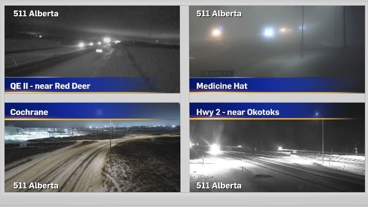
As of 7:30 a.m. Monday, 511 Alberta was still reporting poor driving conditions throughout central and southern Alberta.

A series of well-positioned low pressure systems will hold the daytime highs slightly below seasonal for most of this week in Calgary, with overnight lows slightly warmer than the average -13 C. The next few days will be mostly overcast, so snow cover is likely to stick around.

Calgary Top Stories
-
-
-
-
-
 WEATHER
WEATHER A cooler Thursday, but smoke continues to linger in Calgary
-
-
 WATCH LIVE
WATCH LIVE Alberta premier fights back tears, promises help as Jasper devastated by fire
-


CTVNews.ca Top Stories

'There's mom and dad's house': New video appears to show destruction of Jasper neighbourhood
Video posted to social media on Thursday morning appears to show the charred remains of a Jasper, Alta., neighbourhood.
LIVE NOW
LIVE NOW Multiple homes, businesses 'lost' to wildfire in Jasper National Park: Parks Canada
Officials from Parks Canada and Jasper say "multiple structures, including a number of businesses and homes, in and around the town of Jasper, have been lost" to wildfire in Jasper National Park.
Prince William's 2023 salary revealed in new report
Newly released financial reports show that William, the Prince of Wales, drew a salary of $42.1 million last fiscal year, his first since inheriting the vast and lucrative Duchy of Cornwall.
Jennifer Aniston criticizes JD Vance for 'childless cat ladies' remarks: 'I pray that your daughter is fortunate enough to bear children'
Jennifer Aniston is criticizing JD Vance for comments he made in his past about women without children.
WATCH LIVE
WATCH LIVE Alberta premier fights back tears, promises help as Jasper devastated by fire
Alberta Premier Danielle Smith fought back tears Thursday as she sought to console Jasper residents coming to terms with a community devastated by wildfire.
NASA says no return date yet for astronauts and Boeing capsule at space station
Already more than a month late getting back, two NASA astronauts will remain at the International Space Station until engineers finish working on problems plaguing their Boeing capsule, officials said Thursday.
'Skibidi Toilet:' If you don’t know what it is, you will
'Skibidi Toilet' is already an internet sensation and now its about to get even more exposure.
French sprinter will wear a cap during Olympic opening ceremony after hijab dispute is resolved
French sprinter Sounkamba Sylla will be allowed to participate in the opening ceremony at the Paris Olympics wearing a cap to cover her hair, an agreement reached with the French Olympic Committee after Sylla said she was barred because of her hijab.
Spicy dispute over the origins of Flamin' Hot Cheetos winds up in court
A former PepsiCo executive is suing the company, saying it destroyed his career after questioning his claim that he invented the popular flavor of Cheetos snacks.
Shopping Trends
The Shopping Trends team is independent of the journalists at CTV News. We may earn a commission when you use our links to shop. Read about us.


Edmonton
-
 LIVE NOW
LIVE NOW Multiple homes, businesses 'lost' to wildfire in Jasper National Park: Parks Canada
Officials from Parks Canada and Jasper say "multiple structures, including a number of businesses and homes, in and around the town of Jasper, have been lost" to wildfire in Jasper National Park.
-
'There's mom and dad's house': New video appears to show destruction of Jasper neighbourhood
Video posted to social media on Thursday morning appears to show the charred remains of a Jasper, Alta., neighbourhood.
-
WATCH LIVE
WATCH LIVE Alberta premier fights back tears, promises help as Jasper devastated by fire
Alberta Premier Danielle Smith fought back tears Thursday as she sought to console Jasper residents coming to terms with a community devastated by wildfire.
Lethbridge
-

Lethbridge businesses helping residents beat the heat
Lethbridge has been no stranger to extreme heat over the last couple weeks.
-
Southern Alberta adaptive water skiing clinic growing in popularity
To break down barriers, an adaptive water skiing clinic was held for those with mental and physical disabilities on Tuesday evening...
-
'A revolution': Crown says accused in Coutts murder-conspiracy trial prepared for war
In a heated courtroom exchange, a man accused of conspiring to murder police at the 2022 Coutts, Alta., blockade rejected accusations he and others brought weapons and body armour to the barricade to start a war.
Vancouver
-

Video shows person of interest sought in Surrey sexual assault investigation
Mounties in Surrey, B.C., have released video of a person of interest who investigators are working to identify after a woman was sexually assaulted by a stranger in her home over the weekend.
-
Fire numbers fall in B.C. as fire near Golden destroys structures, spurs evacuation
The Town of Golden, B.C., says a nearby wildfire burning south of the community crossed the Columbia River and has destroyed "several structures."
-
TransLink warns bus service could be cut by half due to budget shortfall
Metro Vancouver's regional transit authority is warning it will have to reduce bus service by half if a $600-million annual funding gap is not filled by next year.
Vancouver Island
-

Fire numbers fall in B.C. as fire near Golden destroys structures, spurs evacuation
The Town of Golden, B.C., says a nearby wildfire burning south of the community crossed the Columbia River and has destroyed "several structures."
-
Can B.C.'s southern resident orcas be taken off the path to extinction?
The southern resident killer whale known as Tahlequah captured global sympathy in 2018 when she pushed the body of her dead calf for more than two weeks in waters off British Columbia's south coast.
-
Vacations, meals, booze: Contractor used $100K of charity's money for personal expenses, B.C. court finds
A B.C. man who was hired to help a non-profit build a food hub but instead spent the money on personal expenses – including travel, restaurants, booze and cannabis – has been ordered to pay more than $120,000 in damages.
Saskatoon
-

Saskatoon man charged with murder in 2023 shooting
A 31-year-old man from Saskatoon is facing a first-degree murder charge in relation to a fatal shooting in December 2023.
-
'A bright light': Trevor LaPlante identified as Prince Albert homicide victim
Prince Albert is grieving the loss of one of its most beloved neighbours and community champions.
-
Sask. police renew calls for information in 44-year-old missing person case
The Prince Albert Police Service (PAPS) is renewing calls for information in the disappearance of Robert Wiggins 44 years ago.
Regina
-

Regina crime rate increases slightly, ranks ninth in country: Stats Can
An annual report from the Canadian Centre for Justice Statistics (CCJS) shows Regina’s crime rate increased slightly from 2022 to 2023.
-
'He's just really unhinged': Sask. comic book fans reflect on Deadpool's ties to Saskatchewan
Ahead of the official release of Marvel Studio's Deadpool and Wolverine, CTV News caught up with comic book aficionados here in Saskatchewan – to explore why the “Regeneratin' Degenerate" is beloved in the province.
-
South Sask. community foundation looking to expand Truth and Reconciliation grant opportunities
The South Saskatchewan Community Foundation (SSCF) has announced they are looking to expand their grant opportunities for Indigenous programming.
Toronto
-

Police identify man and woman killed in quadruple shooting in Toronto
Toronto police have now identified the two victims killed in a quadruple shooting in Scarborough, Ont. early Wednesday morning.
-
New details emerge in wrong-way crash on Hwy. 401 that killed baby and grandparents
Durham Regional Police have confirmed new details about a deadly wrong-way crash on Highway 401 which claimed the lives of a baby and his grandparents following a police chase in April.
-
'Very tragic:' Cyclist dead after being struck by dump truck in Yorkville
A cyclist is dead after being struck by a dump truck in downtown Toronto on Thursday morning, police say. Police say that the female cyclist was travelling westbound in a bike lane and at one point exited the bike lane and continued their journey in the same direction. They were then struck by the dump truck which was also headed westbound, police say.
Montreal
-

3 tornadoes confirmed as truck toppled, trees uprooted south of Montreal
A tornado overturned a truck and uprooted several trees in Brossard on Montreal's South Shore.
-
Nursing student pleads guilty to helping Quebecers get fake COVID-19 passports
A nursing student has pleaded guilty to making fake COVID-19 vaccination records, Quebec's anti-corruption unit said Thursday.
-
Quebec athlete named one of Canada's 2024 Olympic flag bearers
Maude Charron will carry the Canadian flag during Friday's Olympic opening ceremony in Paris. The athlete from Rimouski will also be defending her Olympic gold medal in weightlifting.
Atlantic
-

Death of husband, wife in Rothesay, N.B., still under investigation: police
Police in Rothesay, N.B., say they continue to investigate the deaths of a man and a woman in the town.
-
N.B. wrestler Leo Burke dies at 76, family says
New Brunswick-born wrestler Leo Burke has died at the age of 76, his family says.
-
Insurance claim tally for last year's floods, wildfires in Nova Scotia: $490 million
The Insurance Bureau of Canada says the devastating wildfires and deadly flooding that plagued Nova Scotia last year have resulted in $490 million in insured losses.
Winnipeg
-

Here are the Manitobans receiving province's highest honour
Two doctors on the frontline of Manitoba's COVID-19 fight, a long-serving MLA and the chair of the Truth and Reconciliation Commission are all receiving Manitoba's highest honour Thursday afternoon.
-
Jets owner, The Brothers Landreth save dwindling Winnipeg church, give it added purpose
A saving grace for a dwindling Winnipeg church has come in the form of Winnipeg Jets owner Mark Chipman and Juno-award-winning folk duo The Brothers Landreth.
-
Environment Canada issues heat warning in southern Manitoba
It's going to be hot in southern Manitoba over the next few days and Environment and Climate Change Canada is telling people to be prepared.
Ottawa
-

Tornado near Perth, Ont. during severe weather on Wednesday, Northern Tornadoes Project says
Western University's Northern Tornadoes Project says a tornado touched down near Perth, Ont. Wednesday night, as a series of severe storms moved across eastern Ontario.
-
Hwy. 417 will be closed this weekend for Preston Street bridge replacement. Here's what you need to know
A stretch of Highway 417 through Ottawa will be closed for 82 hours this weekend for the replacement of the aging Preston Street overpass. CTVNewsOttawa.ca looks at what you need to know about the Queensway closure for the replacement of the Preston Street bridge.
-
Man charged with attempted murder following June stabbing in Ottawa's east end
A 38-year-old Ottawa man is facing charges of attempted murder and aggravated assault in connection to a stabbing in Ottawa's east end.
Northern Ontario
-

Worker killed at New Gold mine in northwestern Ont.
An employee operating a piece of equipment in an open pit was killed Wednesday at New Gold's gold mine in Rainy River.
-
'I'm so broke': Two Toronto women speak out after losing $76,000 in romance scam
Two women from the Toronto area are speaking out after losing thousands of dollars to a romance scam, including a single mother who lost $62,000.
-
Greater Sudbury warns of parking ticket text scam
If you recently received a text warning about an overdue parking ticket in Greater Sudbury, it's fake.
Barrie
-
Ont. mayor fires back at 'misinformation' about people defecating on beach
Wasaga Beach's mayor is firing back at unverified claims circulating on social media that people are defecating in the sand at the provincial park.
-
Loose wheel hits 4 vehicles on Highway 400 in Innisfil
Four vehicles sustained damage while travelling along Highway 400 in Innisfil Thursday morning after a wheel came loose.
-
Barrie-Innisfil MPP 'blacked-out' and crashed car into window of child care centre
Staff at a Barrie child care centre say they are frustrated by what they call a local MPP's inadequate response after a car crashed through a window in one of the toddler rooms.
Kitchener
-

Home invasion shooting in Cambridge leads to 3 arrests and serious injuries: WRPS
The Waterloo Regional Police Service (WRPS) have arrested three males, including one teen, in connection to a home invasion shooting on Wednesday night that left multiple people injured.
-
Steven Lorentz hoists the Stanley Cup at Kitchener, Ont. cancer centre
Patients at the Grand River Regional Cancer Centre got a special treat, when Steven Lorentz stopped by the Stanley Cup.
-
Ont. mayor fires back at 'misinformation' about people defecating on beach
Wasaga Beach's mayor is firing back at unverified claims circulating on social media that people are defecating in the sand at the provincial park.
London
-

$1.3-million drug bust by London police
On July 16, police from the guns and gangs section arrested two people after using warrants on two vehicles and a home in Eclipse Walk.
-
Suspect arrested after police said witness to crime was stabbed
On Wednesday, officers were told the suspect wanted in relation to Tuesday's incident may be in the 500 block of Ridout Street near Dufferin Avenue.
-
Groundbreaking MRI technology available at LHSC in London, Ont.
The MAGNETOM Free.Max 0.55T MRI has a lower-strength magnet, artificial intelligence (AI) capabilities, a larger opening for patients, and a dedicated focus on serving less urgent cases, will help reduce wait times for patients while promoting inclusive care.
Windsor
-

City investing $2.24 million in 16 residential road projects
Some residential roads are getting a facelift.
-
Ontario Provincial Police officers ratify 4-year deal to become highest paid cops in the province
Ontario Provincial Police officers are now the highest paid in the province, their union says, after they ratified a four-year deal last week.
-
Violent crime severity index increases by 15.5%
There has been an increase in violent crime investigated by Windsor police, according the 2023 Crime Severity Index released by Statistics Canada.


