Daytime highs to range from 6 C to 11 C above average for the next week
Heat warnings will remain in place, or be expanded, across much of western Canada this week.
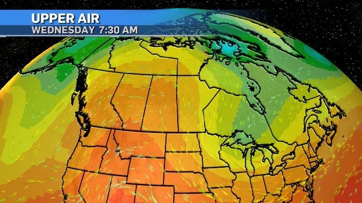
A strong ridge of high pressure is continuing to track north from the U.S. southwest and will be firmly anchored in place by two low pressure systems – one in the northeastern Pacific and one over southern Ontario.
This will prevent the normal meridional flow in the polar jet that moves high and low pressure systems across most of Canada.
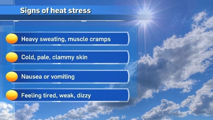
Both daytime highs and overnight lows will hit maximums that are far above seasonal, producing a cumulative health risk due to an increased stress on the body as systems attempt to regulate.
Especially at risk of heat-related impacts are those who might experience earlier or more severe effects including (but not limited to) infants, children, the elderly, people with pre-existing heart, lung, and kidney conditions, diabetics, those who are socially isolated or work outside.
There is also going to be an amplified risk for wildfires, especially once the heat event ends.
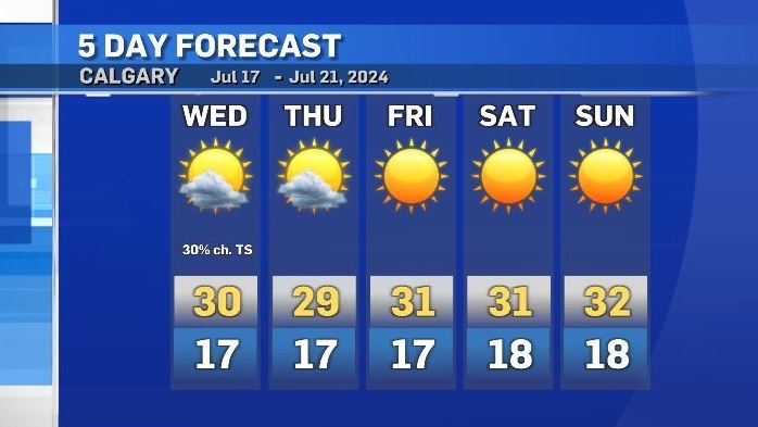
Daytime highs in Calgary are expected to sit between 29 C to 34 C until at least the middle of next week with overnight lows between 17 C and 19 C.
The normal range is 23 C and 10 C.
Shopping Trends
The Shopping Trends team is independent of the journalists at CTV News. We may earn a commission when you use our links to shop. Read about us.


CTVNews.ca Top Stories

W5 Investigates
W5 Investigates 'I never took part in beheadings': Canadian ISIS sniper has warning about future of terror group
An admitted Canadian ISIS sniper held in one of northeast Syria’s highest-security prisons has issued a stark warning about the potential resurgence of the terror group.
'Absolutely been a success': Responders looks back at 988, Canada's Suicide Crisis Helpline, one year later
In its first year, responders for Canada's Suicide Crisis Helpline, known as 988, have answered more than 300,000 calls and texts in communities nationwide.
Prime Minister Trudeau meets Donald Trump at Mar-a-Lago
Prime Minister Justin Trudeau landed in West Palm Beach, Fla., on Friday evening to meet with U.S.-president elect Donald Trump at Mar-a-Lago, sources confirm to CTV News.
Nova Scotia PC win linked to overall Liberal unpopularity: political scientist
Nova Scotia Premier Tim Houston is celebrating his second consecutive majority mandate after winning the 2024 provincial election with 43 seats, up from 34. According to political science professor Jeff MacLeod, it's not difficult to figure out what has happened to Liberals, not just in Nova Scotia but in other parts of Canada.
'Mayday! Mayday! Mayday!': Details emerge in Boeing 737 incident at Montreal airport
New details suggest that there were communication issues between the pilots of a charter flight and the control tower at Montreal's Mirabel airport when a Boeing 737 made an emergency landing on Wednesday.
Hit man offered $100,000 to kill Montreal crime reporter covering his trial
Political leaders and press freedom groups on Friday were left shell-shocked after Montreal news outlet La Presse revealed that a hit man had offered $100,000 to have one of its crime reporters assassinated.
Questrade lays off undisclosed number of employees
Questrade Financial Group Inc. says it has laid off an undisclosed number of employees to better fit its business strategy.
Cucumbers sold in Ontario, other provinces recalled over possible salmonella contamination
A U.S. company is recalling cucumbers sold in Ontario and other Canadian provinces due to possible salmonella contamination.
Billboard apologizes to Taylor Swift for video snafu
Billboard put together a video of some of Swift's achievements and used a clip from Kanye West's music video for the song 'Famous.'
Edmonton
-

Massage therapist charged in connection with sexual assault at Mill Woods clinic
An Edmonton massage therapist has been charged with sexual assault in connection with an incident earlier this year.
-
Lights, markets and parades: Here's what's happening in and around Edmonton this weekend
The holiday magic never stops in Edmonton and the city, and surrounding communities, has plenty happening to keep people busy this weekend.
-
Armed convenience store robber sought by Edmonton police
Police are searching for the man who robbed a convenience store in southwest Edmonton last weekend.
Lethbridge
-

City of Lethbridge launches 'Goosinator' tool to manage waterfowl at lakes
While it may look colourful and cartoonish to humans, a new tool is designed to represent a predator for geese and other species at Henderson Lake to improve water quality.
-
Western Slam basketball tournament tips off in Lethbridge
The inaugural Western Slam tournament got underway Thursday evening at the VisitLethbridge.com Arena.
-
Unattended candle led to fire inside Lethbridge home: officials
An investigation is underway after a fire at a Lethbridge home on Friday.
Vancouver
-

Students push for AEDs at Vancouver schools following friend's death
Following the tragic death of their friend, a group of students is pushing for automated external defibrillators, or AEDs, to be installed in all Vancouver schools.
-
Health authority apologizes after hospital sends blind senior to Downtown Eastside shelter
The Fraser Health authority has issued an apology after 86-year-old Gwendalyn Deraspe was released on Tuesday from Ridge Meadows hospital and sent in a cab by staff to live at a Downtown Eastside women’s shelter.
-
Calgary man claims B.C. trucking company compromised his safety
A Calgary man says a B.C. trucking company did not not listen to his safety concerns during a recent shift.
Vancouver Island
-

Yuletide festivities help kick off holiday season in Greater Victoria
Greater Victoria has a host of yuletide festivities this weekend for residents ready to kick off the holiday season.
-
Supreme Court clears way for B.C. to include other governments in opioid lawsuit
B.C. Attorney General Niki Sharma says a Supreme Court of Canada victory has cleared a "pathway" for governments across the country to go after opioid makers and distributors for damages arising from the opioid crisis.
-
Study of 2023 Okanagan wildfires recommends limiting development in high-risk areas
A study into the devastating wildfires that struck British Columbia's Okanagan region in 2023 has recommended that government and industry limit development in high-fire-risk areas.
Saskatoon
-

Saskatoon temporary smudge location to be taken down
While the City of Saskatoon says it granted a temporary permit for smudging and a ceremonial open fire, that expired at 6p.m. Tuesday night.
-
'A huge value addition': Sask. scientists develop way to make canola meal more profitable
Researchers at the University of Saskatchewan are looking at making the canola crop more profitable.
-
Missing 60-year-old Sask. man found dead
The Saskatchewan RCMP says 60-year-old Clayton Cameron, reported missing earlier this week, has been found dead.
Regina
-

Regina's LED volume wall leaving Sask. months after opening
Less than a year after an LED volume wall was introduced to the film world in Saskatchewan, the equipment is making its exit from the province.
-
Sask. NDP says Scott Moe, staff stayed in Toronto hotel at rate over $800 per night
The Saskatchewan NDP says Premier Scott Moe and three Saskatchewan Party staff members stayed at a hotel in Toronto last June that cost each of them $818.74 per night for a three-night stay.
-
Jury sequestered to find verdict in sexual assault trial against Regina chiropractor
Justice Janet McMurtry sequestered a 12-person jury to determine a verdict against Regina-based chiropractor Ruben Manz.
Toronto
-
 BREAKING
BREAKING Feds announce $758 million in funding for new Line 2 TTC subway trains
The TTC will get funding from the federal government to replace aging trains on Line 2, Deputy Prime Minister Chrystia Freeland has announced.
-
Highway 407 owner says no active buyback discussions with Ontario government
Pressure is increasing on the provincial government to tap into the underused tolled Highway 407 to unclog congestion on Highway 401.
-
Officer's inaccurate testimony 'will undoubtedly tarnish the image of the Toronto Police Service:' police tribunal
A Toronto cop who 'derailed' a criminal investigation by 'inaccurately' testifying that he saw drugs in plain view inside a suspect’s car has been demoted for two years after pleading guilty to discreditable conduct, a decision from the police tribunal read.
Montreal
-

Buying a home? Here's everything you need to know about Quebec's 'welcome' tax
Anyone who has bought a home in Quebec knows the rollercoaster high of making that big, life-changing purchase – and the sudden crash that occurs when the welcome tax bill comes in the mail, alongside its 30-day payment deadline.
-
Montreal researchers make breakthrough discovery in fighting HIV
Researchers in Montreal have made a breakthrough discovery in HIV research by finding a way to expel the virus from its hiding places and destroy it.
-
Hit man offered $100,000 to kill Montreal crime reporter covering his trial
Political leaders and press freedom groups on Friday were left shell-shocked after Montreal news outlet La Presse revealed that a hit man had offered $100,000 to have one of its crime reporters assassinated.
Atlantic
-

Man charged after Halifax high school placed in hold and secure
A man has been charged after a high school in Halifax was placed in hold and secure Friday morning.
-
Teen arrested in connection with weapons call at Fredericton High School
Fredericton Police Force arrested a 14-year-old boy Thursday in relation to a weapons call at Fredericton High School.
-
P.E.I. steps in to help buy mobile park to allow residents to stay in homes
Residents of Evergreen Village mobile home park in Summerside, P.E.I., who have had an eviction notice looming over their heads may be able to stay in their homes after all.
Winnipeg
-

True North officially buys Portage Place Mall
True North Real Estate Development (TNRED) has officially purchased Portage Place Mall.
-
Parts of southwestern Manitoba under extreme cold warning, temperatures could feel like -40
Much of southwestern Manitoba is under an extreme cold warning as the wind chill could make temperatures feel close to minus 40.
-
Manitoba Metis Federation to be first Metis group with modern treaty with Canada
The Manitoba Metis Federation will be the first Metis group to sign a modern treaty with the federal government.
Ottawa
-
 NEW THIS MORNING
NEW THIS MORNING Canadian Army vehicles on roads and highways in the Ottawa area starting this weekend
Attention eastern Ontario drivers! You may see an increased number of Canadian Army vehicles on roads and highways in the Ottawa area starting this weekend, warns the Ontario Provincial Police (OPP).
-
'We will always be a downtown store': Steve's Music Store moving from Rideau Street after 42 years
A staple of the Rideau Street corridor, Steve's Music Store, is packing up and moving out after 42 years in business. The store will not be closing, its manager says, but rather moving to a new location that is yet unannounced.
-
Prime Minister Trudeau meets Donald Trump at Mar-a-Lago
Prime Minister Justin Trudeau landed in West Palm Beach, Fla., on Friday evening to meet with U.S.-president elect Donald Trump at Mar-a-Lago, sources confirm to CTV News.
Northern Ontario
-

Man fined $10K for abandoning homemade barge in Lake Nipissing
A man from Lavigne, Ont., has been fined $10,000 for abandoning a homemade barge in Lake Nipissing.
-
Another 60 cm of snow possible in the Sault as severe weather continues
Closures and cancellations are piling up in Sault Ste. Marie as a major winter storm continues for another day Friday.
-
Heavy police presence on road in Iroquois Falls
Members of the public are being asked to avoid the area of Nellie Lake Road West in Iroquois Falls.
Barrie
-

Man airlifted with critical injuries after Haliburton crash
One person was airlifted to a trauma centre with serious injuries after a collision in Haliburton on Friday.
-
Former Ont. teacher charged with sexually assaulting a teen nearly 50 years ago
A senior from Clearview Township faces charges in connection with an investigation into a sexual assault involving a teen nearly 50 years ago.
-
Jury delivers verdict in Midland landlord's second-degree murder case
The Midland man facing second-degree murder for the death of his tenant in 2021 was found not guilty on Friday.
Kitchener
-

Traffic chaos on Highway 401 through Kitchener
Highway 401, through Kitchener, was brought to a standstill Friday due to an investigation by Ontario Provincial Police.
-
Family of Guelph, Ont. man killed in B.C. crash pushing for case review
The family of a Guelph, Ont. man who was killed in a car crash in British Columbia is pushing for a review of the case, after learning about the charge that a driver involved is now facing.
-
Region of Waterloo considers reducing, and even cutting, some services to keep tax increase down
The Region of Waterloo is considering reducing or eliminating some services in an effort to lower the potential 2025 tax increase.
London
-

City and Byron property owner approach agreement after years of disputes
A settlement appears to be in the works between the city and a property owner in Byron who leveled a historic barn.
-
CTV News London’s top stories from this week
In case you missed it, CTV News London has gathered all of the top local stories from this week into one video for your convenience.
-
Parts of region bracing for up to one metre of snow this weekend
It’s a day for digging in Bruce County. School buses across Bruce and Grey counties were cancelled Friday due to snowsqualls that dumped as much as 15 centimetres of snow on the region overnight.
Windsor
-
 Breaking
Breaking Guilty on all counts: Windsor man convicted of careless driving in Retrofest double fatal collision
The Windsor man charged in connection to the double fatal Retrofest collision has been convicted on all counts.
-
'All the indicators are fantastic': Devonshire Mall braces for record breaking crowds this Black Friday weekend
Thousands of shoppers are expected to head to Devonshire Mall in full force this weekend in search of holiday savings and the best Black Friday deals.
-
Model railroad program inspiring next generation
Model railroading is a popular hobby. It can be as simple as a train on a small oval track or a complex rail system with detailed scenery.


