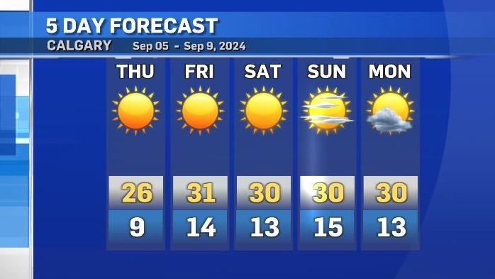
Daytime highs will be at least 11 degrees above average this weekend
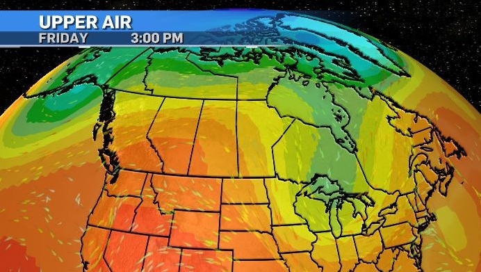
A building ridge of high pressure situated over southern Alberta and B.C. is providing an infusion of warm air and creating stable weather conditions.
Thursday’s daytime high in Calgary will be 26 C, which is seven degrees above average and that maximum temperature will be the coldest of the next five days.
Low pressure systems to the east and west of this ridge will anchor the high in place until at least Monday, elevating both ends of the diurnal temperature cycle and diverting active weather outside of the region.
It is likely heat warnings will be issued for portions of southern Alberta – including in Calgary, as the threshold criteria for a heat warning should be met.
Heat warnings are issued for most of Alberta when daily highs reach at least 29 C with lows of at least 14 C for at least two consecutive days.
Areas outside of major centres might not be placed under the warning if the daily minimum temperature is not achieved – as they lack the boost from the urban heat island effect that occurs in cities like Calgary.
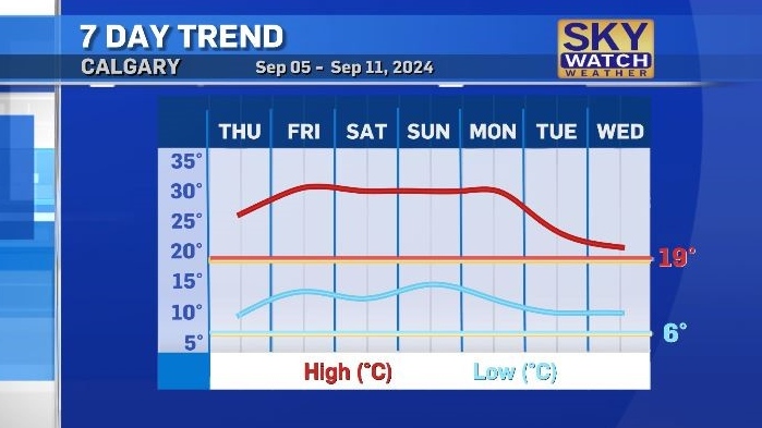
Regardless of whether warnings are issued, these temperatures are unusual.
Evaluating the most recent "normals" climate data from Environment and Climate Change Canada, Calgary typically sees less that one day in September with a daytime high of at least 30 C, and this week will include four. Adding a sobering perspective - will also likely be the warmest weekend until next summer.
Calgary Top Stories
-
-
 DEVELOPING
DEVELOPING Donald Trump was the subject of 'an assassination attempt,' FBI reports
-
-
-
-
-
-


CTVNews.ca Top Stories
DEVELOPING
DEVELOPING Donald Trump was the subject of 'an assassination attempt,' FBI reports
The FBI said Donald Trump was the target of “what appears to be an attempted assassination” at his golf club in West Palm Beach, Fla., on Sunday.
LIVE UPDATES
LIVE UPDATES 2024 Emmy Awards: 'The Bear' starts night off strong with big wins
'Shogun,' 'The Bear' and 'Baby Reindeer' at the topo of the queue as the 76th Primetime Emmy Awards arrive on Sunday.
B.C. to open 'highly secure' involuntary care facilities
B.C. will be opening “highly secure facilities” for people with addiction and mental health issues in the province, officials said Sunday.
They came from Jamaica for work, now they're homeless and out thousands of dollars in lost wages
Abuse of Canada’s temporary foreign worker program has left a group of carpenters from Jamaica 'destitute' after an Ottawa company refused to pay them for nearly half a year of work.
Air Canada deal avoids shutdown, brings relief to passengers and business groups
Travellers, business groups and politicians expressed fervent relief on Sunday after Air Canada and the union representing thousands of its pilots negotiated a new labour deal and averted a disruptive, countrywide shutdown.
Montreal bars, restaurants react to Quebec bill to regulate merchant tipping requests
Quebec tabled a bill on Thursday that would regulate how merchants determine suggested tips, forcing businesses to calculate them based on the price before tax. Restaurant staff and management are divided on the policy.
Queen Victoria's favourite Tuscan villa for sale for more than US$55 million
Once a favoured holiday destination for Queen Victoria, and reputedly described in one of the greatest works of Italian literature, the Villa Palmieri is steeped in history and could now be yours – if you have more than €50 million (US$55 million) lying around.
Liberals will let Conservatives hold non-confidence vote 'fairly soon', no intention of proroguing Parliament
The Liberals have no intention of using procedural tactics to delay the Conservatives' promised non-confidence motion, and they have no plans to prorogue Parliament to hold onto power, according to Government House Leader Karina Gould.
Carbon pricing to cause economic 'nuclear winter,' Poilievre tells his MPs
Conservative Leader Pierre Poilievre signaled the Liberals' carbon price and the economy will remain his prime target when Parliament resumes this week.
Shopping Trends
The Shopping Trends team is independent of the journalists at CTV News. We may earn a commission when you use our links to shop. Read about us.


Edmonton
-

'Craziest thing I've ever seen': Elusive salamanders make surprising mass appearance in Edmonton area
Edmontonians can count themselves lucky to ever see one tiger salamander, let alone the thousands one local woman says recently descended on her childhood home.
-
Man's death in river valley suspicious: EPS
A man is dead after being found seriously injured in the river valley in south-central Edmonton on Saturday.
-
Hunter the Lynx ranked 4th worst Canadian NHL mascot: Survey
Hunter the Lynx, mascot for the Edmonton Oilers, was recently ranked as the fourth-worst Canadian NHL mascot – or fifth best, depending on how you look at it.
Lethbridge
-

Lethbridge police locate man wanted on outstanding warrants
Lethbridge police have located and arrested a man wanted on a number of outstanding warrants.
-
Coaldale man charged with attempted murder after Lethbridge break-and-enter
Lethbridge police say a 28-year-old man is facing charges of attempted murder following a frightening attack on a woman inside her home this week.
-
Police operation near Vauxhall, Alta., ends: RCMP
A police operation in near Vauxhall, Alta. has ended.
Vancouver
-

B.C. to open 'highly secure' involuntary care facilities
B.C. will be opening “highly secure facilities” for people with addiction and mental health issues in the province, officials said Sunday.
-
Person found dead after car fire in Coquitlam parking lot
One person is dead after a car was found on fire in the parking lot of a rec centre in Coquitlam, B.C., Sunday morning, local Mounties confirmed.
-
Earthquakes shake deep below northern British Columbia coast
The northern British Columbia coast was rattled by two earthquakes below the ocean floor on Sunday.
Vancouver Island
-
B.C. to open 'highly secure' involuntary care facilities
B.C. will be opening “highly secure facilities” for people with addiction and mental health issues in the province, officials said Sunday.
-
Air Canada deal avoids shutdown, brings relief to passengers and business groups
Travellers, business groups and politicians expressed fervent relief on Sunday after Air Canada and the union representing thousands of its pilots negotiated a new labour deal and averted a disruptive, countrywide shutdown.
-
DEVELOPING
DEVELOPING Donald Trump was the subject of 'an assassination attempt,' FBI reports
The FBI said Donald Trump was the target of “what appears to be an attempted assassination” at his golf club in West Palm Beach, Fla., on Sunday.
Saskatoon
-

'Human spirit does not stop': Saskatoon's Terry Fox run surpasses fundraising goal
Saskatoon’s 44th annual Terry Fox run took place on Sunday, uniting the community, and country in a shared goal of raising funds for cancer research.
-
Manslaughter charge laid after suspicious death on Sask. First Nation
Police have laid charges in relation to the suspicious death of a 28-year-old man on Beardy's and Okemasis' Cree Nation.
-
'We were scratching our heads': Saskatoon child clinic raises concerns over proposed shelter nearby
There’s more out-cry about a proposed temporary shelter in Saskatoon's downtown core. This time it's from professionals who run a children’s mental health clinic next door, servicing thousands of vulnerable kids each year.
Regina
-

City looking for artists to transform Regina's oldest tree into art
The City of Regina has big plans for one of its oldest trees that was cut down last year.
-
Porch fire in North Central contained quickly: Regina Fire
Regina fire crews were at the scene of a porch fire Saturday evening.
-
Outreach group hosts land-based education session focusing on the role of water
The shoreline of Echo Valley Beach hosted several people looking to learn more about the role water plays in the lives of everyone.
Toronto
-
DEVELOPING
DEVELOPING Donald Trump was the subject of 'an assassination attempt,' FBI reports
The FBI said Donald Trump was the target of “what appears to be an attempted assassination” at his golf club in West Palm Beach, Fla., on Sunday.
-
Air Canada deal avoids shutdown, brings relief to passengers and business groups
Travellers, business groups and politicians expressed fervent relief on Sunday after Air Canada and the union representing thousands of its pilots negotiated a new labour deal and averted a disruptive, countrywide shutdown.
-
'The Life of Chuck' wins the Toronto Film Festival's People's Choice Award
The Toronto International Film Festival's People's Choice Award went to 'The Life of Chuck,' handing Mike Flanagan's Stephen King adaptation one of the most-watched prizes of the fall film festival circuit.
Montreal
-

Montreal protesters decry French-language law impacts in hospitals
Around 50 protestors gathered outside of the Jewish General Hospital on Sunday, objecting to Quebec's French-language law's impact on the health care sector.
-
Montreal group raising awareness for those with borderline personality disorder
A fundraising walk in Montreal was held in support of those with emotional dysregulation such as borderline personality disorder.
-
CTV News Montreal at Six for Sunday, Sept. 14, 2024
CTV News Montreal at Six for Sunday, Sept. 14, 2024 with anchor Matt Gilmour.
Atlantic
-

N.S. wants Canada to bear the full costs for Chignecto Isthmus
After much back-and-forth between the provincial and federal governments, Nova Scotia has moved forward with mitigation work on the Chignecto Isthmus, but the province’s premier says the federal government will have to cover the bill.
-
Ceremony remembers Canada’s contribution to the Battle of Britain
Hundreds gathered on the apron at 12 Wing Shearwater Sunday morning in a ceremony to remember Canada’s contribution to the Battle of Britain.
-
Moncton joins cross-Canada demonstrations for migrant rights
Nine cities across Canada put on demonstrations over the weekend in support of migrant rights as they call for change to happen at a government level.
Winnipeg
-

Winnipeg police investigating fire as homicide after two people die in hospital
Two people are dead after being rescued from a burning Atlantic Ave. building early Saturday morning. Winnipeg police say the fire was suspicious and the homicide unit has taken over the investigation.
-
DEVELOPING
DEVELOPING Donald Trump was the subject of 'an assassination attempt,' FBI reports
The FBI said Donald Trump was the target of “what appears to be an attempted assassination” at his golf club in West Palm Beach, Fla., on Sunday.
-
Hundreds race in 44th annual Terry Fox Run
Hundreds of sneakers hit the pavement and grass in Assiniboine Park on Sunday morning. The annual event, inspired by Terry Fox’s Marathon of Hope more than four decades ago, raises money for cancer research in Canada.
Ottawa
-

Beechwood Cemetery ceremony remembers Canadian contributions to the Battle of Britain
The Royal Canadian Air Force (RCAF) marked 84 years since the Battle of Britain in a ceremony on Sunday at Beechwood National Military Cemetery.
-
Ottawa residents rally for Mahsa Amini, push for change in Iran
Hundreds of Ottawa residents gathered in front of Parliament Hill to mark the second anniversary of Mahsa Amini's death and to renew calls for change in Iran.
-
Ottawa OPP charge two impaired drivers in less than an hour Saturday night
Two drivers are facing impaired driving charges after being caught allegedly driving under the influence in two separate incidents Saturday night in Ottawa, according to the Ontario Provincial Police.
Northern Ontario
-

Greater Sudbury resident dies in 5-vehicle crash involving 3 motorcycles near Port Dover
A person from Greater Sudbury died and two other individuals were transported to hospital after a five-vehicle crash near Port Dover, Ont., late Saturday afternoon.
-
Carbon pricing to cause economic 'nuclear winter,' Poilievre tells his MPs
Conservative Leader Pierre Poilievre signaled the Liberals' carbon price and the economy will remain his prime target when Parliament resumes this week.
-
Liberals will let Conservatives hold non-confidence vote 'fairly soon', no intention of proroguing Parliament
The Liberals have no intention of using procedural tactics to delay the Conservatives' promised non-confidence motion, and they have no plans to prorogue Parliament to hold onto power, according to Government House Leader Karina Gould.
Barrie
-

OPP searching waters of Georgian Bay for missing youth
A search is underway in Penetanguishene for a youth who went missing while swimming at Huronia Park on Sunday.
-
Thousands take part in Terry Fox Run throughout Simcoe-Muskoka
The Simcoe-Muskoka region raised more than $100,000 in support of cancer research, as thousands took part in their nearest Terry Fox Run on Sunday.
-
One person dead in three-vehicle crash in Mulmur
One person is dead after a three-vehicle crash in Mulmur township Saturday afternoon.
Kitchener
-

Sisters finally see the Canadian 'aviation artifact' built by their father nearly 90 years ago
Two sisters have finally been reunited with a plane their father built 90 years ago, that is also considered an important part of Canadian aviation history.
-
Man injured in Cambridge shooting
A 19-year-old man has been taken to hospital after a shooting in Cambridge.
-
Most-read stories of the week: assault with a weapon charge over water gun, man-made island in the Grand River, and Friday the 13th roars into Port Dover
Charges laid after a neighbour was sprayed with a water gun, a man-made island appears in the Grand River, and bikers flock to Port Dover for Friday the 13th.
London
-

Hundreds turn out for London's 44th annual Terry Fox run
The spirit of Terry Fox took over Springbank Park in London Sunday, as hundreds laced up for the annual Terry Fox Run.
-
One person dead following five vehicle collision in Port Dover
Norfolk OPP say they were on the scene of a five vehicle collision on Blueline Road in Port Dover on Saturday evening at around 6:00 p.m.
-
Charity golf tournament raises $80k for Strathroy hospice
The eleventh annual ‘Power of Golf Fore Charity’ tournament at Caradoc Sands Golf Club on September 10 raised $80,000 to support a future hospice in Strathroy.
Windsor
-
DEVELOPING
DEVELOPING Donald Trump was the subject of 'an assassination attempt,' FBI reports
The FBI said Donald Trump was the target of “what appears to be an attempted assassination” at his golf club in West Palm Beach, Fla., on Sunday.
-
Windsor Residence for Young Men shows progress made through $152k grant
On Wednesday, the Windsor Residence for Young Men (WRYM) gave MPP’s Andrew Dowie and Lisa Gretzky a look into the effect of the $152,800 grant that they received.
-
Lauzon congestion prompts concerns from Windsor councillor
A Windsor councillor has raised concerns about traffic congestion on the east end of the city.


