Heat warnings will drop soon; storms possible this weekend in Calgary
AFTERNOON UPDATE: Tonight has a small chance to yield showers, still, to add to the haze and cloud we've been offered. Wind speeds are quite strong already this afternoon, with gusts steady around 40 km/h this week.
Moving into the weekend, storm risks remain, and with them, our chance for severe storms has fallen. It's not gone - but it's dropped substantially in the wake of our ongoing convective inhibition. Otherwise, the storm risk is starting to populate a bit higher Sunday.
MORNING EDITION: It took a few days to get there, but we're starting to see the visualized editions of the thunderstorm potential in our forecast for Saturday evening.
The chance is slimmer even now than it was yesterday; a crisper model image displays instead that activity could deviate wide around Calgary. The current renderings are all over the map; some models are calling for a 3 p.m. storm tomorrow, and others think it won’t roll by until 2 a.m. Sunday. I look at our best chance for storms as part of the daytime heating cycle; therefore, storm activity around the dinner hour becomes most likely.
I have been remiss to mention today's conditions – they simply don't amount to much in our case. Hot, dry conditions are the dominant feature of our forecast. The heat warning continues.
Skipping ahead to Sunday, another shot at showers or thundershowers will sit staunchly atop Saturday's motion; in fact, Sunday holds dependencies on what Saturday does. If we don't get much Saturday, we’re less likely to deal with it Sunday. Convective inhibition may play that role.
After a lengthy stay beneath the ridge, we're on our way out thereafter. It’ll still take until the midweek, but seasonally-normal conditions are coming, and they're bringing showers along for the ride.
YOUR FIVE-DAY CALGARY FORECAST
Friday
- Evening: risk of showers early, low 17 C
Saturday
- Partly cloudy, risk of p.m. thundershowers
- Daytime high: 30 C
- Evening: showers, risk of thundershowers, low 16 C
Sunday
- Partly cloudy, risk of p.m. thundershowers
- Daytime high: 27 C
- Evening: clear, low 16 C
Monday
- Partly cloudy, p.m. showers
- Daytime high: 28 C
- Evening: clear, low 15 C
Tuesday
- Scattered showers
- Daytime high: 22 C
- Evening: clear, low 13 C
Wednesday
- Mainly cloudy, scattered showers
- Daytime high: 23 C
- Evening: clear, low 14 C
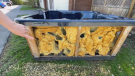
Helen near Milk River caught a nice sunset pic for the photo of the day.
 Viewer Helen's photo of a sunset near Milk River, Alta.
Submit your weather photos here to see them featured in our article, and perhaps even as the pic of the day during our News at Six! You can also share on Twitter, or to our Instagram at @CTVCalgaryWeather.


CTVNews.ca Top Stories

Canadian gov't proposes new foreign influence registry as part of wide-spanning new bill
Prime Minister Justin Trudeau's government is proposing a suite of new measures and law changes aimed at countering foreign interference in Canada, amid extensive scrutiny over past meddling attempts and an ever-evolving threat landscape.
Boeing Starliner capsule's first crewed test flight postponed
The long-awaited first crewed test flight of Boeing's new Starliner space capsule was called off for at least 24 hours over a technical issue that launch teams were unable to resolve in time for the planned Monday night lift-off.
Teacher charged in historical sexual assault of Calgary teenage girl
Calgary police have charged a teacher with the alleged sexual assault of a teenage girl more than 20 years ago.
Winnipeg man admits to killing four women, argues he's not criminally responsible
Defence lawyers of Jeremy Skibicki have admitted in court the accused killed four Indigenous women, but argues he is not criminally responsible for the deaths by way of mental disorder – this latest development has triggered a judge-alone trial rather than a jury trial.
Man banned from owning animals after fatal Calgary dog attack
The owner of three Calgary dogs that got loose and mauled a woman to death in 2022 has been ordered to pay a $15,000 fine within one year and banned from owning any animal for 15 years.
East-end Ottawa family dealing with massive rat infestation
Residents in Ottawa’s Elmridge Gardens complex are dealing with a rat infestation that just won’t go away. Now, after doing everything they can to try to fix the issue, they are pleading with the city to step in and help.
Mediterranean staple may lower your risk of death from dementia, study finds
A daily spoonful of olive oil could lower your risk of dying from dementia, according to a new study by Harvard scientists.
An El Nino-less summer is coming. Here's what that could mean for Canada
As Canadians brace themselves for summer temperatures, forecasters say a weakening El Nino cycle doesn’t mean relief from the heat.
Newfoundland and Labrador latest province to tighten rules on Airbnbs
Newfoundland and Labrador is the latest jurisdiction to bring in stricter rules for short-term rentals, with a coming set of regulations that will force operators to register with the provincial government.
Shopping Trends
The Shopping Trends team is independent of the journalists at CTV News. We may earn a commission when you use our links to shop. Read about us.


Edmonton
-

Edmonton businesswoman fined, put on house arrest for scamming newcomers
An Ontario woman working in Edmonton has been convicted of defrauding newcomers of tens of thousands of dollars.
-
Alberta Municipalities said it hasn't been given chance to consult on changes to bill
Alberta's municipal affairs minister declined Monday to clarify whether towns and cities would still get their say before changes are made to a contentious bill that gives the province broad authority to fire local councillors.
-
Second-degree murder charge laid in Alberta Avenue death
A 24-year-old man has been charged in the death of a 44-year-old man in the Alberta Avenue area last Friday.
Lethbridge
-

Lethbridge police seek suspects in 'street robbery'
Lethbridge police are looking for two people they believe were involved in the 'street robbery' of a senior last week.
-
Southern Alberta animal shelters overrun with abandoned pets
Animal shelters across the province are finding themselves frequently at capacity -- or more.
-
Woman charged in connection with fatal crash
Lethbridge police say impaired driving is to blame in a fatal crash that killed a 25-year-old man on Thursday.
Vancouver
-

Closing arguments underway for accused in Richmond restaurant murder
Closing arguments are underway in the trial of a man accused of killing an alleged money launderer and wounding his associate at a Richmond, B.C., restaurant in September 2020.
-
Canucks enter second round as underdogs against Edmonton Oilers
Despite a better regular season record, including a clean sweep of the Edmonton Oilers, the Vancouver Canucks are entering the second round series between the two teams as underdogs.
-
Vancouver high school teacher pleads guilty to sexual assault
A former band teacher at a Vancouver high school has pleaded guilty to sexually assaulting one of his former students, CTV News has learned.
Vancouver Island
-

Victoria the only city to pass B.C. home-building target so far
Under the province’s new housing targets, Victoria was tasked with creating 659 new units within the first year. It has hit 753 in six months.
-
B.C. court date set for 3 accused of murdering Sikh activist Hardeep Singh Nijjar
Three suspects accused of murdering British Columbia Sikh activist Hardeep Singh Nijjar last year are scheduled to appear in court in Surrey on Tuesday.
-
B.C.'s human rights commissioner calls on universities to protect student protesters
Amid ongoing protest encampments on university campuses in B.C., the province’s human rights commissioner is calling on institutions to protect free speech.
Saskatoon
-

Police say Sask. man assaulted hospital staff the night before killing his mother
Prince Albert police say a 29-year-old man charged in the murder of his mother had assaulted a staff member at Victoria Hospital the night before the killing.
-
The lone road into this Sask. village is so bad some locals drive through the ditch
Aaron Fosseneuve says the official name of the road into his home community of Cumberland House is Highway 123, but locals joke it’s not as easy as 1-2-3 — “it’s more like a 4-5-6.”
-
Saskatoon Blades superfans excited for game 7 against Moose Jaw Warriors
The Saskatoon Blades and Moose Jaw Warriors are getting ready for what’s sure to be an epic game seven at Sasktel Centre, capping off one of the tightest series in recent history.
Regina
-

Sask. NDP criticizes nearly $1 million spent on former Prime Minister's consulting firm
The Government of Saskatchewan has paid former Prime Minister Stephen Harper's consulting firm nearly $1 million over the past four years for trade advice. The opposition says it has been blocked while trying to gather more details on the contract.
-
'Absolutely critical': Looming rail worker strike causing concern for Sask.'s biggest industries
The possibility of a strike by both Canadian National (CN) and Canadian Pacific Kansas City (CPKC) rail workers has Saskatchewan's major economic drivers sounding alarms.
-
Hudson's Bay in Regina to close in 2025
The Hudson's Bay department store location at Regina's Cornwall Centre will close its doors in 2025.
Toronto
-

Kendrick Lamar and Drake gave us an epic hip-hop beef weekend. Here’s what to know
Two of hip-hop’s biggest stars have beef and people are taking sides.
-
'Real despair': High-ranking Toronto police officer felt isolation, mistreatment at TPS pushed her to help officers cheat on exam, lawyer says
The first female Black superintendent in Toronto Police Service history was attempting to diversify the ranks on her own when she helped six constables cheat in a promotions exam, her lawyer told a police tribunal.
-
Ontario MPP asked again to leave Ontario legislature over keffiyeh, Speaker loosens ban
An Ontario MPP was asked again to leave the Ontario legislature on Monday for wearing a keffiyeh, a garment that was banned by the Speaker last month due to its political symbolism.
Montreal
-

Pro-Palestinian encampment members say little progress made in meeting with McGill
Pro-Palestinian protesters who have set up an encampment at Montreal's McGill University say they're no closer to taking down their tents after meeting with members of the school administration.
-
'Incendiary objects' found under machinery at future Northvolt site in Quebec, company says
'Incendiary objects' have allegedly been placed under machinery on the site of Northvolt's future battery plant in Monteregie, seriously endangering employees, according to the company.
-
Nearly 5,000 Quebec teachers have quit in the last five years: report
According to a report by French-language media outlet the Journal de Montreal, from 2018 to 2023, the number of teachers quitting increased by 76 per cent, for a total of 4,880.
Atlantic
-

N.S. crews searching for missing man in capsized boat
The Joint Rescue Coordination Centre (JRCC) is searching for a man missing from a capsized recreational boat in Annapolis County, N.S., Monday night.
-
Concern over speeding in Fredericton neighbourhood grows after 2 teens, young adult killed in crash
Three people – including two teens – are dead, and two others are injured after a crash that has left a greater Fredericton community shaken.
-
IWK looking for missing 17-year-old patient
The IWK Health Centre in Halifax is looking for a 17-year-old patient who has gone missing.
Winnipeg
-
Winnipeg man admits to killing four women, argues he's not criminally responsible
Defence lawyers of Jeremy Skibicki have admitted in court the accused killed four Indigenous women, but argues he is not criminally responsible for the deaths by way of mental disorder – this latest development has triggered a judge-alone trial rather than a jury trial.
-
Butterfly Garden at the Leaf takes flight again after closure
Springtime is here and a popular attraction at The Leaf is undergoing a metamorphosis.
-
Manitoba to use tobacco suit windfall to fight cancer: Premier
A windfall from a lawsuit against big tobacco could see a major expansion to help cancer patients.
Ottawa
-
East-end Ottawa family dealing with massive rat infestation
Residents in Ottawa’s Elmridge Gardens complex are dealing with a rat infestation that just won’t go away. Now, after doing everything they can to try to fix the issue, they are pleading with the city to step in and help.
-
'He was a nice kid': Sir Guy Carleton students remember teen stabbed to death
Students from Sir Guy Carleton Secondary School have placed roses outside the city building in Nepean where one of their classmates was stabbed on Thursday and later died of his injuries.
-
Ottawa photo radar camera on road connecting Ontario-Quebec issues 7,500 speeding tickets in one month
Newly released statistics show the photo radar camera on King Edward Avenue, between Cathcart Street and St. Patrick Street, issued 7,569 tickets during its first month of operation in March.
Northern Ontario
-

Northern Ont. woman charged in fatal head-on Highway 17 crash
A 32-year-old northern Ontario woman has been charged in a head-on collision on Highway 17 near Espanola that killed one and seriously injured two others Sunday.
-
City of Timmins launches pilot sharp collection program
When people find drug litter on public property in Timmins, the city wants them to contact Service Timmins.
-
Man charged with child abduction in northern Ont. elects for trial by judge
A Brampton man in his 30s charged with abducting a northern Ontario boy last summer has elected to be tried by a judge without a jury.
Barrie
-

YMCA celebrates successes with major changes on the horizon
Friends and passionate supporters of the YMCA gathered tonight to celebrate some major accomplishments of the last year as the organization looks toward a busy timeline in the coming years.
-
Sentences handed down in Barrie catwalk shooting
Sentencing has been handed down to two men who pleaded guilty for their roles in a Barrie catwalk shooting last spring that left the victim fighting for his life.
-
Motorcyclist airlifted with serious injuries after Owen Sound collision
A motorcyclist was airlifted via air ambulance after a collision in an Owen Sound intersection.
Kitchener
-

OPP urge safety as another wrong-way driver spotted on Highway 401
There have been two fatal wrong-way collisions on Highway 401 in the last week, and on Sunday, another driver was seen travelling in the opposite direction near Cambridge, Ont.
-
Stratford resident banned from city property and contacting staff
A couple of Stratford residents claim they have been banned from attending any city owned properties or from speaking with any city staff for three months.
-
Man accused of stealing more than $300K in products from LCBO stores
A Guelph, Ont. man is believed to be responsible for stealing more than $300,000 worth of product from LCBO stores across the province.
London
-

'So scared there's going to be a tragedy': Vacant building in OEV raises concern among residents
Homeowners living near the former McCormick/Beta Brands building are again raising the alarm over a structure that has been vacant for nearly two decades.
-
Morgan, Lewis pitch extending winter shelter spaces through July so city can consider year-round proposal
A last ditch effort at city hall might see the doors to Ark Aid Street Mission’s winter homeless shelter remain open past the end of this month.
-
Jury at abuse case hears children sought refuge at friend's home
A London, Ont. jury heard evidence on Monday that the children at the centre of a sexual abuse case sought refuge at the home of family friends just before they went to police.
Windsor
-

Family of nurse, 22, who died after surgery complications establish scholarship in her honour
With an infectious giggle and a strong desire to help others, Hannah Pare had all the tools to be a spectacular nurse. But that thrill has quickly turned into heartbreaking agony for Hannah's family after complications from a routine surgery cut her life short.
-
Tecumseh considers removing crossing guards, parents concerned
The Town of Tecumseh could soon be without crossing guards altogether, as council considers a plan to phase them out.
-
Windsor city councillor calls for school board, police collaboration to tackle youth crime
Ward 4 Coun. Mark McKenzie is calling for greater collaboration between the Greater Essex County District School Board (GECDSC) and the Windsor Police Service in response to a recent rise in youth crime across the city.


