Gradual warmup continues, return to seasonal temperatures next week
On paper, Thursday might look similar to Wednesday, but the day will feel quite different.
The low-pressure system that brought snow to southern Alberta early in the week is continuing to track east along the southern portions of Saskatchewan and Manitoba.
Because the gradient around the low is strong and the system is quite large, the counter-clockwise circulation remains a driver for the conditions in Alberta which sits on the western edge.
Colder air will continue to be pulled in from the north on Thursday and Friday before a pattern change over the weekend. North winds of 20 km/h are likely in Calgary for most of Thursday.
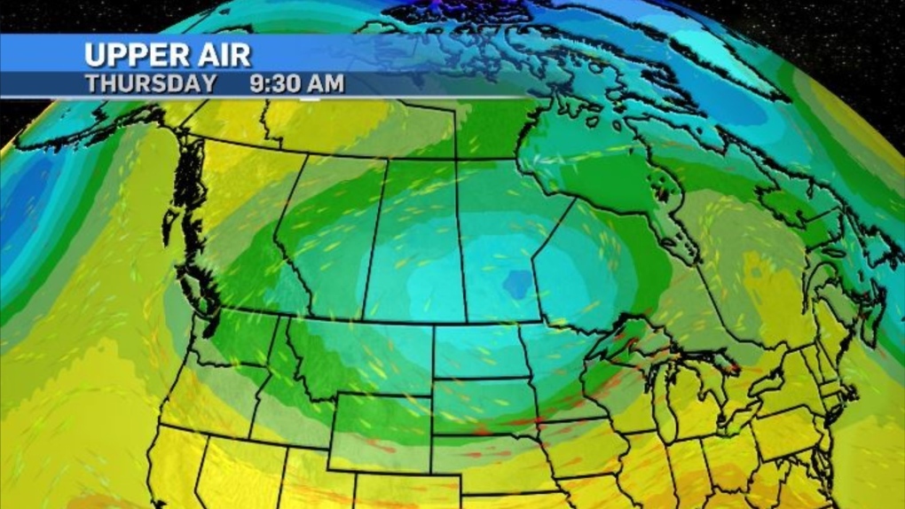 An upper air map of Canada on April 18, 2024, as of 9:30 a.m. (CTV News)
The winds will ease off on Friday, however, daytime highs are expected to sit around 10 degrees below seasonal until Saturday.
A ridge of high pressure will start to move west-to-east through B.C. Saturday, and by Sunday Calgary could experience some brief instability with mixed precipitation possible.
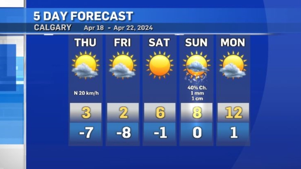 Calgary five-day forecast for April 18-22, 2024. (CTV News)
Daytime highs for much of southern Alberta will return to seasonal starting Monday and settle a few degrees above seasonal by early next week.


CTVNews.ca Top Stories

Trump returns to his campaign facing a warning of jail time if he violates a trial gag order
Donald Trump on Wednesday will use a one-day break from his hush money trial to rally voters in the battleground states of Wisconsin and Michigan, a day after he was held in contempt of court and threatened with jail time for violating a gag order.
Ontario woman surprised after 20-year-old fines suddenly tank credit score
An Ontario woman says that she was shocked when provincial fines from 20 years ago suddenly tanked her credit score last week, but the situation may not be as unusual as it seems, according to at least one debt expert.
Anger can harm your blood vessel function, study shows
Stress and anger can have a negative impact on cardiovascular health, studies have shown. New research points to just how the mechanism may work.
Freeland leaves capital gains tax change out of coming budget implementation bill, here's why
Deputy Prime Minister and Finance Minister Chrystia Freeland will be tabling yet another omnibus bill to pass a sweeping range of measures promised in her April 16 federal budget, though left out of the legislation will be the government's proposed capital gains tax change.
Newfoundland fisherman says police broke his leg during protest that delayed budget
Richard Martin is spending this year's fishing season on land after he says a Royal Newfoundland Constabulary officer broke his left leg in three places during a protest last month that shut down the provincial legislature.
A 98-year-old in Ukraine walked miles to safety from Russians, with slippers and a cane
A 98-year-old woman in Ukraine who escaped Russian-occupied territory by walking almost 10 kilometres (six miles) alone, wearing a pair of slippers and supported by a cane has been reunited with her family days after they were separated while fleeing to safety.
Will an 'out of sight, out of mind' cellphone policy make a difference in Ontario schools?
Ontario’s cellphone ban in schools has been met with mixed reaction, with some teachers concerned about constant policing of kids and experts applauding the change as necessary for student learning.
A Utah couple accidentally shipped their cat with an Amazon return. A week -- and 3 'miracles' -- later, they were on a plane to meet a stranger
The Amazon returns employee wasn't at work the day one of her colleagues at a California warehouse found a small, furry stowaway in a box mailed six days earlier from Utah. But Brandy Hunter got the call anyway.
Duelling protesters clash at UCLA hours after police clear pro-Palestinian demonstration at Columbia
Dueling groups of protesters clashed Wednesday at the University of California, Los Angeles, grappling in fistfights and shoving, kicking and using sticks to beat one another. Hours earlier, police burst into a building at Columbia University that pro-Palestinian protesters took over and broke up a demonstration that had paralyzed the school while inspiring others.
Shopping Trends
The Shopping Trends team is independent of the journalists at CTV News. We may earn a commission when you use our links to shop. Read about us.


Edmonton
-

Cenovus teams with First Nations to build northern Alberta homes amid housing crisis
Raoul Montgrand, president of the Chard Métis Nation in northern Alberta, called a 200-square-foot camper trailer home for close to two years.
-
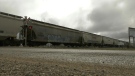
It's opening day for the $34B Trans Mountain oil pipeline expansion
Wednesday marks the official start date of the long-awaited $34-billion Trans Mountain oil pipeline expansion project.
-
'Person of interest' sought in Hangar 11 fire
Edmonton police are looking for a man they say is a person of interest in the Hangar 11 suspicious fire.
Lethbridge
-
Alberta-to-Montana passenger train would benefit economy, tourism: report
The rail line from Lethbridge to Coutts is used solely for freight trains, but a new feasibility study done by Integrated Travel Research and Development looks at the potential of adding a passenger train.
-
'Odd request': Suspect asked woman for chili powder after Lethbridge kidnapping, robbery
Police are releasing more details about the kidnapping and robbery of a senior in Lethbridge, which included a strange request for spices, in hopes of identifying a suspect.
-
Guinness World Record attempt made in Drumheller, Alta.
Thousands of people dressed as dinosaurs descended on Drumheller, Alta., on Saturday.
Vancouver
-

'Under siege' Deep Cove reducing visitor parking for the summer
If your summer plans include hiking Quarry Rock or eating a famous doughnut, you may want to leave your car behind.
-
Predators claw out 2-1 win over Canucks in Game 5, keep season alive
The Nashville Predators kept their season alive with a 2-1 victory over the Vancouver Canucks in Game 5 of their first-round playoff series Tuesday.
-
Shrewd investment or frivolous spending? Economic benefits of Vancouver World Cup games in question
When all three levels of government defended the ballooning price tag to host several 2026 FIFA World Cup games in Vancouver, they repeated a claim of significant economic benefits that experts and critics are questioning.
Vancouver Island
-

Harbour Air launches direct flights from Vancouver to Butchart Gardens
Floatplane operator Harbour Air will offer direct flights this summer from downtown Vancouver to Butchart Gardens on Vancouver Island, landing its seaplanes in a remote cove behind the historic horticultural attraction.
-
B.C. police are rarely charged for killing or harming civilians. A watchdog wants prosecutors' choices reviewed.
B.C.'s police watchdog wants a review of how prosecutors handle cases where officers kill or seriously harm members of the public, saying low rates of charges and convictions are casting doubt on the province's system of accountability.
-
Hosting Vancouver's FIFA World Cup games could cost half a billion dollars
Hosting seven games in Vancouver during the 2026 FIFA World Cup could cost more than half a billion dollars, according to an updated estimate provided Tuesday.
Saskatoon
-

'Brutal, cruel, and frankly inhumane': Sask. RCMP describe the sprawling investigation of Tiki Laverdiere's murder
The last of 10 people convicted in the brutal killing of a 25-year-old Edmonton woman was sentenced on Friday, closing a chapter on one of the largest homicide investigations for the Saskatchewan RCMP Major Crimes Investigations unit.
-
'That fire was jumping roads': Sask. First Nation councillor pleads for caution in wake of runaway grass fire
A band councillor at Red Pheasant Cree Nation says he’s considering putting up surveillance cameras around the community in the wake of a runaway grass fire that nearly destroyed several homes on Monday.
-
Saskatoon police set to begin search of landfill for remains of missing woman
On Wednesday, Saskatoon police begin a search for the remains of Mackenzie Lee Trottier in the city's landfill. CTV News will be on site at 42 Valley Road Wednesday morning as Staff Sgt. Corey Lenius from the major crimes section provides more details.
Regina
-

Sask. sees decrease in local businesses over past year: Statistics Canada
According to new numbers released from Statistics Canada, there was a decrease in local businesses in Saskatchewan over the past year.
-
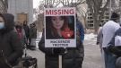
'More than just statistics': Government of Saskatchewan proclaims Missing Persons Week
A ceremony and walk around Wascana Park was held in Regina on Tuesday to honour the more than 140 long-term missing persons in Saskatchewan.
-
Regina police say 8 people arrested during incident where officer was accidently shot
Regina police say eight people were arrested in an incident that involved an officer being inadvertently shot by another officer’s gun last week.
Toronto
-

Ontario woman surprised after 20-year-old fines suddenly tank credit score
An Ontario woman says that she was shocked when provincial fines from 20 years ago suddenly tanked her credit score last week, but the situation may not be as unusual as it seems, according to at least one debt expert.
-
Motorcyclist rushed to hospital without vital signs after crash on Hwy. 401 in Scarborough
A motorcyclist has been rushed to hospital without vital signs following a crash on Highway 401 in Scarborough, Ontario Provincial Police say.
-
Loblaw reports Q1 profit and revenue up from year ago, raises quarterly dividend 15%
Grocery and drugstore retailer Loblaw Cos. Ltd. raised its quarterly dividend by 15 per cent as it reported its first-quarter profit and revenue rose compared with a year ago.
Montreal
-
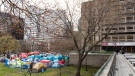
McGill students demand injunction to limit where protesters can go
A judge is expected to render a decision Wednesday morning on whether the pro-Palestinian encampment at McGill University can stay or not.
-
Transit fares are going up in the Montreal area. Here's the new price structure
Transit riders, take note: the Montreal-area regional transit authority, the ARTM, is changing its fare structure on July 1. Prices are going up by an average of 3 per cent.
-
Woman killed before fire in Montreal home: police
A 42-year-old woman was killed before her body was found in a fire in Montreal's Pointe-aux-Trembles district, according to Montreal police.
Atlantic
-

Name of 'armed man' who prompted emergency alert in Dartmouth, N.S., released by police
Residents in the area of Gaston Road in Dartmouth, N.S., were asked to shelter in place Tuesday morning as police searched for an armed suspect.
-
N.S. medical examiner finds 2 Bass River deaths not suspicious
The deaths of two people in Bass River, N.S., are not believed to be suspicious, according to a medical examiner.
-
WATCH
WATCH Moose strolls through Fredericton
A Fredericton woman is awe-struck after seeing a moose stroll down a city street on Tuesday.
Winnipeg
-

Avalanche eliminate Winnipeg Jets from playoffs with 6-3 road win
Mikko Rantanen's first two goals of the playoffs propelled the Colorado Avalanche to a 6-3 victory over the Winnipeg Jets on Tuesday that clinched their opening-round playoff series in five games.
-
Peguis First Nation declares state of emergency over chronic flooding, deplorable housing conditions
Cheryl-Lee Spence and her children have been displaced by flooding on Peguis First Nation multiple times.
-
Winnipeg police respond to five incidents involving knives, hatchet in 24 hours
Winnipeg police were kept busy this week responding to a string of incidents involving knives and a hatchet.
Ottawa
-

Students launch pro-Palestinian encampment at uOttawa
A group of students have launched an encampment at the University of Ottawa (uOttawa) calling on the institution to cut financial ties with Israel.
-
Ottawa shoppers plan to boycott Loblaw-owned stores starting Wednesday
A boycott targeting Loblaw-owned stores is gaining momentum online, with thousands of shoppers taking their money elsewhere for the month of May.
-
NEW THIS MORNING
NEW THIS MORNING Could be 'couple of years' to build up parliamentary policing, Ottawa police chief says
Ottawa Police Chief Eric Stubbs says it could take 'a couple of years' to build up a team of officers specifically dedicated to local policing duties in the Parliamentary Precinct in downtown Ottawa.
Northern Ontario
-

After car chase, young driver in Sudbury tries to run away from police
A 20-year-old suspect in Sudbury was arrested last week after trying to escape from police responding to reports of erratic driving.
-
Poilievre kicked out of Commons after calling Prime Minister Justin Trudeau 'wacko'
Testy exchanges between the prime minister and his chief opponent ended with the Opposition leader and one of his MPs being ejected from the House of Commons on Tuesday -- and the rest of Conservative caucus walking out of the chamber in protest.
-
Baby, grandparents among 4 people killed in wrong-way police chase on Ontario's Hwy. 401
A police chase which started with a liquor store robbery in Bowmanville Monday night ended in tragedy some 20 minutes later when a suspect fleeing police entered Highway 401 in the wrong direction and caused a pileup which killed an infant and the child's grandparents, as well as the suspect, investigators say.
Barrie
-
Fatal bicycle collision in Caledon
A cyclist was killed in a crash in Caledon Township.
-
OPP locate knife-wielding man in Alliston
OPP in Alliston have located an armed man after a search on Tuesday.
-
Road rage driver handed conditional sentence
Nearly a year to the day Joshua Wheatley was caught on camera running a man over in an apparent road rage incident, the 22-year-old has been given a conditional sentence for six months, including partial house arrest with a curfew.
Kitchener
-

Kitchener shooting victim found in wooded area
A man was airlifted to a trauma centre Tuesday after a shooting in Kitchener.
-
WATCH
WATCH Arnold Schwarzenegger spotted filming in Elora, Ont.
The name of the project has not been officially released although it’s widely believed to be the Netflix series FUBAR.
-
Residential fire in Cambridge leaves seven people displaced
Seven people have been displaced following a late night fire in Cambridge.
London
-

Investigation underway after 25 year old suffers life-threatening injuries in construction accident
OPP and the Ministry of Labour are investigating after a 25-year-old individual sustained life-threatening injuries during a construction accident in Lucan Biddulph.
-
Development delays blamed on update to UTRCA floodplain maps that’s years behind schedule
Simmering tensions between the Upper Thames River Conservation Authority (UTRCA) and planning officials at city hall are now out in the open.
-
Lawyers for world junior hockey players back in court
The sexual assault case against five former Canadian world junior hockey players was back in London court on Tuesday. Lawyers representing the players dealt with the matter briefly via Zoom.
Windsor
-
Ontario premier in Wallaceburg on Wednesday
Ford along with the Presient and CEO of the Chatham-Kent Health Alliance, Lori Marshall, will be making a special announcement regarding the 'Our Hospital Our Future: Wallaceburg Site Redevelopment Project.'
-
Friends, co-workers remember 'lovely soul' killed in fatal weekend motorcycle crash
A 19-year-old University of Windsor student is being remembered as an energetic and charismatic soul following a fatal two-vehicle collision over the weekend.
-
Sexual assault of a minor investigation leads to arrest
Windsor police are investigating the sexual assault of a minor. A 27-year-old man has been arrested after police got a complaint that a girl under the age of 16 was sexually assaulted by a man.


