Mid-week cooldown with overnight temperatures around freezing
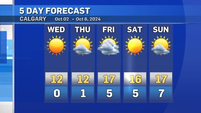
The next two days will be cooler for much of the Prairies, including Alberta.
Both daytime highs and overnight lows will be slightly below seasonal for most of southern Alberta, with early morning temperatures at or below freezing in many communities.
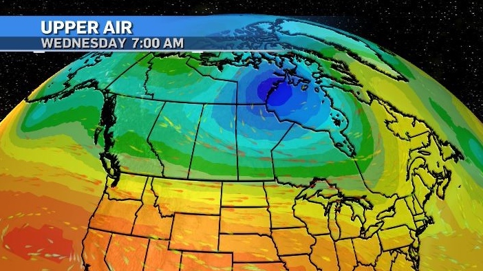
The main weather-maker for most of the country is a potent low pressure system parked over Hudson Bay.
That low is drawing cooling air from the north and filtering it back toward the west coast. In the southeastern Pacific a high pressure system is reinforcing a zonal pattern (creating a west to east flow along the southern borders of B.C., Alberta, Saskatchewan, Manitoba and Ontario).

Later Thursday, that ridge will start to track northeast and should disrupt that pattern while introducing warmer temperatures by the weekend.
With less than 12 hours between sunrise and sunset right now any amplified temperatures during the day will be reset overnight due to that shorter period of incoming solar radiation.

CTVNews.ca Top Stories

W5 Investigates 'I never took part in beheadings': Canadian ISIS sniper has warning about future of terror group
An admitted Canadian ISIS sniper held in one of northeast Syria’s highest-security prisons has issued a stark warning about the potential resurgence of the terror group.
'Absolutely been a success': Responders looks back at 988, Canada's Suicide Crisis Helpline, one year later
In its first year, responders for Canada's Suicide Crisis Helpline, known as 988, have answered more than 300,000 calls and texts in communities nationwide.
Prime Minister Trudeau meets Donald Trump at Mar-a-Lago
Prime Minister Justin Trudeau landed in West Palm Beach, Fla., on Friday evening to meet with U.S.-president elect Donald Trump at Mar-a-Lago, sources confirm to CTV News.
Nova Scotia PC win linked to overall Liberal unpopularity: political scientist
Nova Scotia Premier Tim Houston is celebrating his second consecutive majority mandate after winning the 2024 provincial election with 43 seats, up from 34. According to political science professor Jeff MacLeod, it's not difficult to figure out what has happened to Liberals, not just in Nova Scotia but in other parts of Canada.
'Mayday! Mayday! Mayday!': Details emerge in Boeing 737 incident at Montreal airport
New details suggest that there were communication issues between the pilots of a charter flight and the control tower at Montreal's Mirabel airport when a Boeing 737 made an emergency landing on Wednesday.
Hit man offered $100,000 to kill Montreal crime reporter covering his trial
Political leaders and press freedom groups on Friday were left shell-shocked after Montreal news outlet La Presse revealed that a hit man had offered $100,000 to have one of its crime reporters assassinated.
Questrade lays off undisclosed number of employees
Questrade Financial Group Inc. says it has laid off an undisclosed number of employees to better fit its business strategy.
Cucumbers sold in Ontario, other provinces recalled over possible salmonella contamination
A U.S. company is recalling cucumbers sold in Ontario and other Canadian provinces due to possible salmonella contamination.
Billboard apologizes to Taylor Swift for video snafu
Billboard put together a video of some of Swift's achievements and used a clip from Kanye West's music video for the song 'Famous.'


