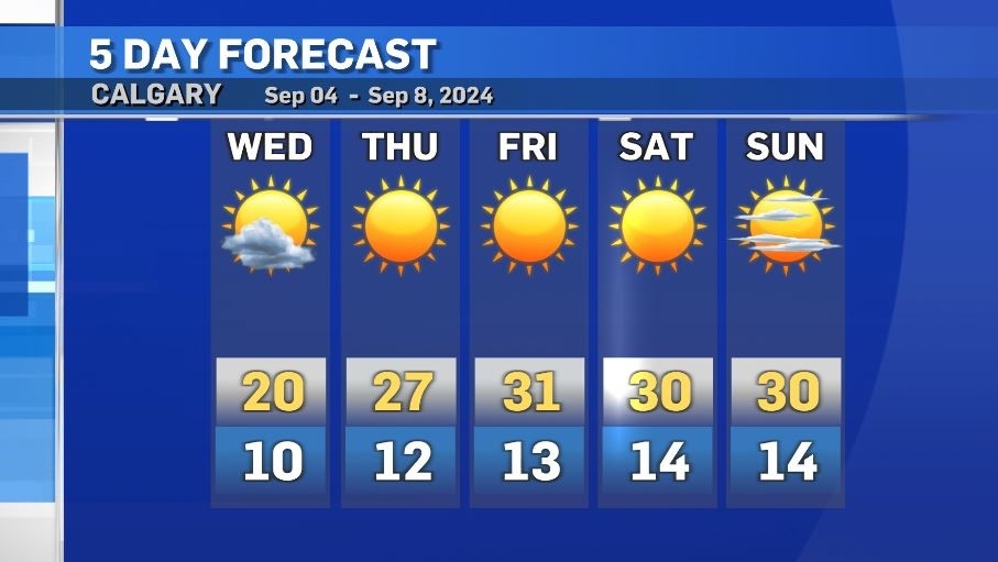
Mild mid-week conditions with heat warnings likely by the weekend
Wednesday’s daytime high of 20 C looks like an outlier compared to the rest of the week but, actually the other days are the exceptional portion of the forecast.
Despite a more northerly influence on Wednesday, it is unlikely active weather will develop, however a wind of 15 to 20 km/h will have a slight impact on how the afternoon will feel.
A strong ridge of high pressure is expected to move in to the southern Prairies on Thursday before it is anchored by lows to the southeast and southwest.
This ridge will become the main weather-maker into early next week, driving daytime highs between 10 C to 13 C above seasonal with daily lows between 4 C to 8 C above average.
During this run of 30 C temperatures conditions will be stable with minimal wind and consistently clear skies.
It is likely portions of southern Alberta, including Calgary, will be placed under heat warnings by Environment and Climate Change Canada (ECCC) as threshold criteria should be met.
Heat warnings are issued by ECCC for most of Alberta when daily highs reach at least 29 C along with lows of at least 14 C for at least two consecutive days.


CTVNews.ca Top Stories

B.C. to open 'highly secure' involuntary care facilities
B.C. will be opening “highly secure facilities” for people with addiction and mental health issues in the province, officials said Sunday.
Trump's campaign says candidate is safe after gunshots were reported in his vicinity in Florida
Donald Trump's campaign says he is safe after gunshots were reported in his vicinity Sunday afternoon in Florida.
They came from Jamaica for work, now they're homeless and out thousands of dollars in lost wages
Abuse of Canada’s temporary foreign worker program has left a group of carpenters from Jamaica 'destitute' after an Ottawa company refused to pay them for nearly half a year of work.
Montreal bars, restaurants react to Quebec bill to regulate merchant tipping requests
Quebec tabled a bill on Thursday that would regulate how merchants determine suggested tips, forcing businesses to calculate them based on the price before tax. Restaurant staff and management are divided on the policy.
TIFF audience prizes for 'Life of Chuck,' Hip doc; Rankin among Canadian winners
'The Life of Chuck,' an offbeat film by writer-director Mike Flanagan, wins the People's Choice Award at the Toronto International Film Festival.
Queen Victoria's favourite Tuscan villa for sale for more than US$55 million
Once a favoured holiday destination for Queen Victoria, and reputedly described in one of the greatest works of Italian literature, the Villa Palmieri is steeped in history and could now be yours – if you have more than €50 million (US$55 million) lying around.
Air Canada deal avoids shutdown, brings relief to passengers and business groups
Travellers, business groups and politicians expressed fervent relief on Sunday after Air Canada and the union representing thousands of its pilots negotiated a new labour deal and averted a disruptive, countrywide shutdown.
U.S. says claims of CIA plot to kill Maduro are 'categorically false' after Venezuela arrests six foreigners
The U.S. State Department has rejected claims of CIA involvement in an alleged plot to kill Venezuela's leader Nicolas Maduro, after Venezuelan authorities said they had arrested six foreigners, including a U.S. Navy SEAL.
What are your rights as a neighbour in Canada?
If you have beef with your neighbour and you feel it's gone too far, what should you do? A personal injury lawyer has some advice.
Shopping Trends
The Shopping Trends team is independent of the journalists at CTV News. We may earn a commission when you use our links to shop. Read about us.


Edmonton
-

2 teens killed, 5 injured in suspected drunk driving crash near Consort
Two teenagers are dead and five are injured after a crash near Consort early Sunday morning.
-
'Armed and dangerous' Edmonton man wanted in killing at Sunchild gas station: RCMP
A man has been arrested and another is wanted in connection with the killing of man after a fight at the Sunchild First Nation gas station in 2023.
-
Health minister walks back claim about abortion access in hospitals
Health Minister Adriana LaGrange played down concerns that transferring some hospitals to Covenant Health would negatively impact reproductive health care, but the minister’s claim about abortion access is contradicted by provincial policy and data.
Lethbridge
-

Lethbridge police locate man wanted on outstanding warrants
Lethbridge police have located and arrested a man wanted on a number of outstanding warrants.
-
Coaldale man charged with attempted murder after Lethbridge break-and-enter
Lethbridge police say a 28-year-old man is facing charges of attempted murder following a frightening attack on a woman inside her home this week.
-
Police operation near Vauxhall, Alta., ends: RCMP
A police operation in near Vauxhall, Alta. has ended.
Vancouver
-
B.C. to open 'highly secure' involuntary care facilities
B.C. will be opening “highly secure facilities” for people with addiction and mental health issues in the province, officials said Sunday.
-
Highway 5 north of Kamloops closed due to crash, fuel spill
Highway 5 north of Kamloops is closed Sunday while crews continue to clean up a fuel spill that happened after a tanker truck crash.
-
Air Canada deal avoids shutdown, brings relief to passengers and business groups
Travellers, business groups and politicians expressed fervent relief on Sunday after Air Canada and the union representing thousands of its pilots negotiated a new labour deal and averted a disruptive, countrywide shutdown.
Vancouver Island
-
B.C. to open 'highly secure' involuntary care facilities
B.C. will be opening “highly secure facilities” for people with addiction and mental health issues in the province, officials said Sunday.
-
Air Canada deal avoids shutdown, brings relief to passengers and business groups
Travellers, business groups and politicians expressed fervent relief on Sunday after Air Canada and the union representing thousands of its pilots negotiated a new labour deal and averted a disruptive, countrywide shutdown.
-
Victoria man who stole from investors banned from market, BCSC says
A Victoria man who pleaded guilty to theft following an investigation by B.C.'s securities regulator has now been banned from the investment market.
Saskatoon
-

'We were scratching our heads': Saskatoon child clinic raises concerns over proposed shelter nearby
There’s more out-cry about a proposed temporary shelter in Saskatoon's downtown core. This time it's from professionals who run a children’s mental health clinic next door, servicing thousands of vulnerable kids each year.
-
RCMP investigating suspicious death after body found in Sask. home
Saskatchewan RCMP major crimes unit is investigating a suspicious death after the body of a 28-year-old man was discovered in a home on Beardy's and Okemasis' Cree Nation.
-
Air Canada deal avoids shutdown, brings relief to passengers and business groups
Travellers, business groups and politicians expressed fervent relief on Sunday after Air Canada and the union representing thousands of its pilots negotiated a new labour deal and averted a disruptive, countrywide shutdown.
Regina
-

City looking for artists to transform Regina's oldest tree into art
The City of Regina has big plans for one of the oldest trees in the city that was cut down last year.
-
Porch fire in North Central contained quickly: Regina Fire
Regina fire crews were at the scene of a porch fire Saturday evening.
-
Outreach group hosts land-based education session focusing on the role of water
The shoreline of Echo Valley Beach hosted several people looking to learn more about the role water plays in the lives of everyone.
Toronto
-

'The Life of Chuck' wins the Toronto Film Festival's People's Choice Award
The Toronto International Film Festival's People's Choice Award went to 'The Life of Chuck,' handing Mike Flanagan's Stephen King adaptation one of the most-watched prizes of the fall film festival circuit.
-
Motorcyclist critically injured after colliding with cargo van in Toronto's west end: police
A 21-year-old motorcyclist suffered life-threatening injuries after a collision with a cargo van in Toronto’s west end on Saturday night, Toronto police say.
-
Air Canada deal avoids shutdown, brings relief to passengers and business groups
Travellers, business groups and politicians expressed fervent relief on Sunday after Air Canada and the union representing thousands of its pilots negotiated a new labour deal and averted a disruptive, countrywide shutdown.
Montreal
-

Montreal protesters decry French-language law impacts in hospitals
Around 50 protestors gathered outside of the Jewish General Hospital on Sunday, objecting to Quebec's French-language law's impact on the health care sector.
-
Montreal group raising awareness for those with borderline personality disorder
A fundraising walk in Montreal was held in support of those with emotional dysregulation such as borderline personality disorder.
-
75-year-old Quebec water-skier, a world champion
Mont-Tremblant water-skier Pierre Plouffe, 75, is back from the world championships with a shiny first-place trophy in his age category.
Atlantic
-

N.S. wants Canada to shell out $4.6 billion for Chignecto Isthmus
After much back-and-forth between the provincial and federal governments, Nova Scotia has moved forward with mitigation work on the Chignecto Isthmus, but the province’s premier says the federal government will have to cover the bill.
-
Ceremony remembers Canada’s contribution to the Battle of Britain
Hundreds gathered on the apron at 12 Wing Shearwater Sunday morning in a ceremony to remember Canada’s contribution to the Battle of Britain.
-
Moncton joins cross-Canada demonstrations for migrant rights
Nine cities across Canada put on demonstrations over the weekend in support of migrant rights as they call for change to happen at a government level.
Winnipeg
-

Homicide unit investigating after fire victims die in hospital
Two people are dead after being rescued from a burning Atlantic Ave. building early Saturday morning. Winnipeg police say the fire was suspicious and the homicide unit has taken over the investigation.
-
Air Canada deal avoids shutdown, brings relief to passengers and business groups
Travellers, business groups and politicians expressed fervent relief on Sunday after Air Canada and the union representing thousands of its pilots negotiated a new labour deal and averted a disruptive, countrywide shutdown.
-
'We're serving Manitoba's greatest needs': Kinsmen Club of Winnipeg marking 100th anniversary
The Kinsmen Club of Winnipeg held its first meeting on Feb. 20, 1924. The club is marking its 100th anniversary this month.
Ottawa
-

Here's how you can watch CTV News at Six on Sundays during the NFL season
With CTV broadcasting NFL football games on Sundays this season, CTV News at Six with Austin Lee will be broadcasting live on our website and the CTV News App.
-
Ottawa woman dies after battle with pancreatic cancer
An Ottawa woman who raised more than $500,000 for cancer research at the Ottawa Hospital has died after a lengthy battle with pancreatic cancer.
-
Pedestrian fatally struck by vehicle in Gatineau, Que.
A pedestrian has died after being struck by a vehicle Saturday night in Gatineau, Que., police say.
Northern Ontario
-

Liberals will let Conservatives hold non-confidence vote 'fairly soon', no intention of proroguing Parliament
The Liberals have no intention of using procedural tactics to delay the Conservatives' promised non-confidence motion, and they have no plans to prorogue Parliament to hold onto power, according to Government House Leader Karina Gould.
-
Northern Ontario beekeeper says she lost nearly 2 million bees this season
CTV News Northern Ontario provides and update on the story of more than 1.5 million bees be lost earlier this summer.
-
Carbon pricing to cause economic 'nuclear winter,' Poilievre tells his MPs
Conservative Leader Pierre Poilievre signaled the Liberals' carbon price and the economy will remain his prime target when Parliament resumes this week.
Barrie
-

One person dead in three-vehicle crash in Mulmur
One person is dead after a three-vehicle crash in Mulmur township Saturday afternoon.
-
Barrie park renamed in honour of Grzegorz 'Greg' Pierzchala
Dozens of community members came together in Barrie on Saturday to remember the life of Provincial Constable Grzegorz "Greg" Pierzchala by renaming a city park in his honour.
-
Baycats win Dominico Cup
The Barrie Baycats defeated the Guelph Royals 6-2 in Game 4 of the IBL Finals in Guelph Saturday night to win the Jack and Lynne Dominico Cup.
Kitchener
-

Sisters finally see the Canadian 'aviation artifact' built by their father nearly 90 years ago
Two sisters have finally been reunited with a plane their father built 90 years ago, that is also considered an important part of Canadian aviation history.
-
Man injured in Cambridge shooting
A 19-year-old man has been taken to hospital after a shooting in Cambridge.
-
Most-read stories of the week: assault with a weapon charge over water gun, man-made island in the Grand River, and Friday the 13th roars into Port Dover
Charges laid after a neighbour was sprayed with a water gun, a man-made island appears in the Grand River, and bikers flock to Port Dover for Friday the 13th.
London
-

Hundreds turn out for London's 44th annual Terry Fox run
The spirit of Terry Fox took over Springbank Park in London Sunday, as hundreds laced up for the annual Terry Fox Run.
-
One person dead following five vehicle collision in Port Dover
Norfolk OPP say they were on the scene of a five vehicle collision on Blueline Road in Port Dover on Saturday evening at around 6:00 p.m.
-
Charity golf tournament raises $80k for Strathroy hospice
The eleventh annual ‘Power of Golf Fore Charity’ tournament at Caradoc Sands Golf Club on September 10 raised $80,000 to support a future hospice in Strathroy.
Windsor
-

Trump's campaign says candidate is safe after gunshots were reported in his vicinity in Florida
Donald Trump's campaign says he is safe after gunshots were reported in his vicinity Sunday afternoon in Florida.
-
Windsor Residence for Young Men shows progress made through $152k grant
On Wednesday, the Windsor Residence for Young Men (WRYM) gave MPP’s Andrew Dowie and Lisa Gretzky a look into the effect of the $152,800 grant that they received.
-
Lauzon congestion prompts concerns from Windsor councillor
A Windsor councillor has raised concerns about traffic congestion on the east end of the city.


